![]()
Prev Page--Minerals || Next Page--References
Sedimentary structures
In addition to rocks and minerals, Kansas has a number of other formations that are best labeled "sedimentary structures." These formations, although composed of Kansas rocks and minerals, require additional explanation. Some, such as concretions or cone-in-cone, may be mistaken for fossils. Others, such as geodes, can be spectacularly beautiful. Some structures, such as ripple marks, give clues about the climate and geology during geologic history.
Concretions
Concretions are masses of inorganic sedimentary materials in other sediments. They are generally harder than the rocks surrounding them, and therefore many of them are weathered out of the rocks. Concretions may be formed from any of a number of minerals. In Kansas they consist of calcite, limonite, barite, pyrite, or silica, the last in the form of opal, chert, chalcedony, or quartz. The shapes vary from round to oval or long and narrow. Many of them have irregular shapes that can be described as lumpy or globular. The smallest concretions are oolites, which measure less than two millimeters in diameter (or smaller than the head of a pin); the largest are many feet across.
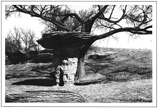
Concretions are formed at the time the sediment is deposited, shortly after deposition, or after the sediment has hardened. Water, containing chemical elements, deposits the material either in cavities in the rock or around the rock particles, cementing them together to form a hardened mass. Kansas has many interesting concretions. In the volcanic-ash deposits, such as those near Calvert in Norton County and south of Quinter in Gove County, are concretions of ash cemented with calcite. Loess deposits also have small areas of calcite forming irregularly shaped nodules. Sandstones in the Dakota and Kiowa formations of the central part of the state have many large concretions, also the result of calcite cement. The largest of these (at Rock City in Ottawa County) have diameters of up to 27 feet.
Mushroom Rocks State Park in Ellsworth County.
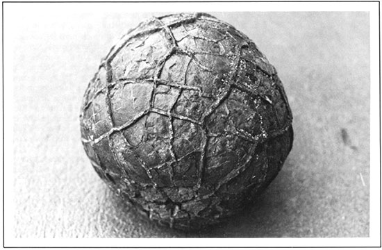
The dark shales of the Cretaceous have a special type called septaria or septarian concretions. These are large concretions cut by many veins filled with yellow to brown calcite and occasionally other minerals, such as barite, gypsum, sphalerite, or quartz. They are thought to have been formed by shrinkage of concretions, causing cracks in the outer layers and thus opening spaces in which minerals were deposited. Small septarian concretions are sometimes called "thunder-eggs." They can be found in many places; one of the best localities is one-half mile south of Hobbie Lake in Osborne County.
Septarian Concretion, About the Size of a Volleyball, from North-Central Kansas.
Geodes
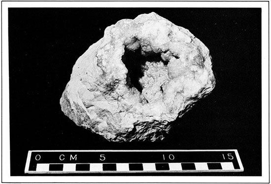
Geodes, a type of concretion, are crystal-lined cavities in rocks. Geodes are formed by ground water that deposits minerals in solution on the walls of rock cavities. This type of deposition usually forms good crystals, most of which point toward the center of the cavity. Geodelike forms occur in fossil shells, and the entire shell may become lined with crystals. The minerals deposited may be quartz, calcite, barite, pyrite, galena, sphalerite, celestite, or dolomite.
Kansas geodes consist mostly of quartz, chalcedony, and calcite. Geodes are quite common and can be found in many localities. They have been reported near the town of Rock along the Walnut River in Cowley County; from the rocks on the hill just north of the Walnut River north of the town of Douglass in Butler County; near Chapman in Dickinson County; and from Riley, Cherokee, Marshall, Logan, Trego, Brown, and Wallace counties. Many good quartz geodes have been reported from Chase County.
Geode from Creswell Formation in Dickinson County.
Cone-in-cone
Cone-in-cone is a peculiar structure consisting of nests of cones, one inside another, standing vertically and arranged either in thin beds or at the edges of large concretions. Some cones are less than an inch in height, and others are as much as 10 inches high. They have a ribbed or scaly appearance. Most cone-in-cone is composed of impure calcium carbonate, but occasionally the structure has been found in gypsum, siderite, and hard coal.
In Kansas cone-in-cone is abundant in the Kiowa Shale of Cretaceous age, where it occurs as beds extending laterally for many feet. When eroded or weathered out, it breaks into small pieces that may easily be mistaken for "chopwood" or petrified wood. Although cone-in-cone may look like fossilized wood, it is an inorganic structure, not the result of any fossil. Good specimens may be found in the banks of the Smoky Hill River and along the edge of Kanopolis Lake in Ellsworth County. Cone-in-cone also has been reported from the limestones in Montgomery, Lyon, McPherson, Washington, and other counties.
Mud cracks and rain prints
When muddy sediments are formed in shallow water, they are often exposed long enough at low tides or in dry seasons to permit drying and cracking. Fossil mud cracks are very similar to present-day mud cracks, except that further deposition has filled in the cracks and preserved them. Fossil mud cracks, when uncovered by erosion, may look like a honeycomb of ridges on a bedding plane.
Raindrop impressions may be preserved under the same conditions. Raindrops may make pits in soft sediments; the shape of the minute rim around the pit may indicate the direction from which the rain came.
Casts of salt crystals
When salty mud dries, its surface becomes more or less covered with crystals of halite. Many of these crystals are cubes, but some have hollow faces and are known as "hopper" crystals. As they are covered up by more sediments, the salt itself may be dissolved, but the crystal outlines are commonly preserved (filled with mud or silt) and are known as salt casts. These features are found in many shales and siltstones, and they are particularly common in some of the Permian red beds of south-central Kansas.
Ripple marks
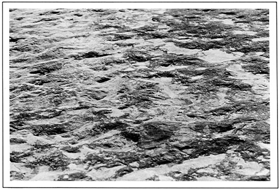
Ripple marks in many sandstones and siltstones are troughs and ridges that look like the ripples in loose sand in a stream, shallow lake, sea, or sand dune. Because of this similarity, observers can make shrewd guesses about the rock's origin and direction of prevailing winds. Other fossil ripple marks may be similar to the ripples in dune sand, indicating that the sandstone in which they are found was deposited by the wind.
Some of the water-type ripple marks are symmetrical from crest to crest, and some are not. The symmetrical ripple marks have been formed by waves in standing water, whereas the asymmetrical ripples were formed by water currents. Water-current ripple marks will tell observers what direction the water came from because the gentle slope faces the current and the steep slope is away from it, or downstream.
Ripple marks are common in Kansas sandstones, but some of the best can be found in a sandstone in the Bandera Shale in Bourbon County.
Ripple Marks in Chautauqua County Sandstone.
Prev Page--Minerals || Next Page--References
Kansas Geological Survey
Placed on web Feb. 28, 2017; originally revised and reprinted 1998.
Comments to webadmin@kgs.ku.edu
The URL for this page is http://www.kgs.ku.edu/Publications/Bulletins/ED2/05_struc.html