![]()
Prev Page--Contents || Next Page--Kansas Rocks
Geologic history of Kansas
Geologists estimate the age of the earth to be at least 4.5 billion years, and in those years many things have happened. Mountains have been raised and eroded down, then raised again. Seas have advanced over the land; layers of sand, mud, and lime carbonate have been deposited on the sea floors, and the waters have retreated, leaving strata of rock thousands of feet thick. Volcanoes have erupted, just as they are doing in many places today, and lava fields have formed. Volcanic dust or "ash" has settled on the earth, sometimes in lakes or ponds, burying whatever lay beneath. Great glaciers, formed during long cold periods, have at times covered a large part of North America, but then melted back with the coming of warmer climates.
All these events have taken place during the geologic history of the earth. Just as human history is divided into major segments, like the Stone Age and the Bronze Age, the four billion years of earth history have been divided into large units of time called eras, and these in turn have been divided into smaller units called periods. The rocks that were formed in anyone period are named after that time and are subdivided into smaller units called formations.
Dividing and subdividing are not enough. Each of the eras and periods--and the rock formations deposited during these parts of geologic time--must be given a name so that one person can recognize any unit referred to by another person. The names of the eras seem long and complicated, but several of them describe the life that existed during the era's timespan. The oldest or first era is the Precambrian, which includes the time from the formation of the earth up to about 600 million years ago. After the Precambrian was the Paleozoic Era (paleozoic means "early life"), and it lasted from 600 million to about 240 million years ago. The succeeding eras are the Mesozoic (middle life) and Cenozoic (recent life).
Eras have been divided into smaller units of time called periods, which have been named in a different way. Some were named from large geographic features. For example, the name Pennsylvanian was chosen for one period because many rocks of that age are found in Pennsylvania. The word Cretaceous, on the other hand, means chalk-bearing, and rocks of Cretaceous age in many places are made of chalk.
Geologic timetable and Kansas rock chart.
Rock formations are named from some geographical feature--such as a town, a river, a mountain--at or near where the particular rock units are well exposed. Thus, the Wellington Formation, deposited during the Permian Period of the Paleozoic Era, was so named because it is well exposed in the region around Wellington, Kansas.
Some of the eras were much longer than others and, likewise, the periods were not of equal length. The shortest period, the Quaternary, began one to two million years ago, and the two longest lasted about 80 million years each. The geologic timetable lists the eras, periods, and typical rocks of each as found in Kansas and includes the estimated length of each period.
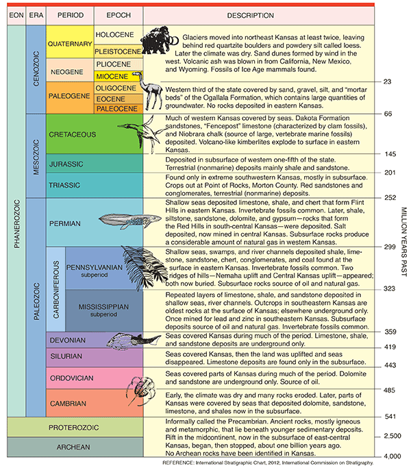
Outcrop of Mississippian Limestone in Cherokee County.
In general, the oldest rocks were deposited first and lie below the younger rocks that were laid down later. Consequently, in geologic timetables it is customary to put the oldest rocks at the bottom and the youngest rocks at the top.
As is evident from this timetable, Kansas has had a long and varied history. Most of the early history is known only from subsurface data gathered by studying samples collected during well drilling and by the indirect methods of geophysics. For example, Precambrian rocks underlie the entire state but do not appear at the surface. Most Precambrian rocks are igneous (such as granite) and metamorphic in nature and have been covered by younger sedimentary rocks. Geologists often refer to the Precambrian as "basement rock" because it underlies the sedimentary rock of Kansas the way a basement lies beneath a house.
Beginning with rocks from the Mississippian Period of geologic history, however, geologists can study formations that crop out at the surface in the southeastern-most corner of Kansas. Those rocks show that during the early Paleozoic, Kansas was undergoing alternate lowering and raising of the land. When the land was lowered, the sea advanced, but when the land was raised, the sea retreated and erosion set in. These conditions lasted through the Mississippian Period, during which time limestone and occasionally shales were deposited.
During the Pennsylvanian Period, the land was flat and near sea level. Deposits of this period are unusual in that they show a regular alternation of sandstone, shale, limestone, shale, and sandstone. Geologists call this regular sequence of rocks" cyclic sedimentation," and it is evidence that the sea level was slowly fluctuating. Generally, where the water was deepest, limestone was deposited. But as the seas became shallower, shale and then sandstone were laid down, with the sequence beginning again when the oceans deepened.
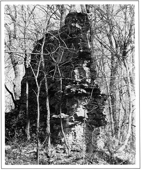
A Coal Mine in Crawford County.
Fossils are common in these Pennsylvanian deposits and some of the limestones consist almost entirely of the shells of sea animals. Pennsylvanian coal deposits are common. The coal was formed from the remains of plants that lived in brackish swamps. These plant remains were buried by later deposits as the sea came over the region and were converted into coal during compaction. Good exposures of Pennsylvanian rocks showing alternations of shale and limestone exist in many places in eastern Kansas.
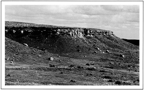
The early part of the next period, the Permian, was much like the Pennsylvanian, although during most of the time the sea covered the region and little coal was formed. During the early Permian, limestone and shale were deposited, including many of the rocks that form the Flint Hills. Sometime during the Permian, however, the seawater began to change in composition. Because seawater contains large quantities of dissolved salts such as calcium carbonate, calcium sulfate, and sodium chloride, a salt residue is left behind when seawater evaporates. Seemingly, the Permian sea in Kansas became partly separated from the main body of the ocean, and the water in this sea left layers of sodium chloride (which we call simply salt) and calcium sulfate (gypsum and anhydrite) many feet thick. A supply of water must have been coming into this inland sea from the ocean in order to provide enough salt to form deposits so thick. At times the sea was drained and sand and silt were deposited over the salt, gypsum, and shale. These Permian deposits include the red beds of south-central Kansas. The sand and silt were washed down from the distant mountains and deposited along the shores of the retreating Permian sea. The red beds have gypsum, salt, and dolomite interbedded with them.
Permian Shale and Gypsum in Barber County.
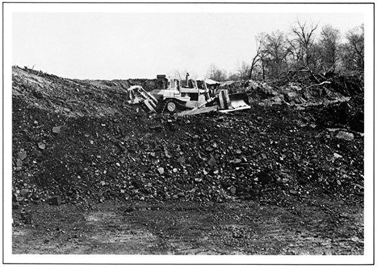
The Permian Period ended about 240 million years ago and was followed by a long interval of non-deposition and erosion in Kansas. Rocks of Jurassic age, about 175 million years old, underlie much of western Kansas and crop out in two locations in Morton County in southwestern Kansas. Rocks of Jurassic age crop out at Point of Rocks in Morton County, a landmark along the Santa Fe Trail.
Ogallala Formation and Underlying Jurassic Rock at Point of Rocks in Morton County.
The next rocks laid down in Kansas were those of Cretaceous age. The sea again came over the region, this time leaving a succession of sands, muds, and chalks, alternating with near-marine stream, swamp, and beach deposits. The well-known chalk of Kansas was deposited late in the Cretaceous, about 60 million years ago. Another famous Cretaceous deposit of Kansas and adjoining states is the Dakota Formation, frequently called a sandstone because the most prominent beds-those that cap the hills and stand out as cliff formers-are sandstones. These sandstone layers are the source of water in many wells in the central and western parts of the state. Approximately 80% of the Dakota Formation, however, consists of clays of many colors. The formation also contains beds of lignite, used by the early pioneers for heating their homes.
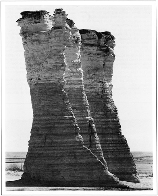
Cretaceous Chalk Formation at Monument Rocks in Gove County.
Exceptionally good fossil specimens found in the Upper Cretaceous beds have made Kansas rocks world-famous among fossil experts. These fossils include fishes, batlike flying reptiles, swimming lizardlike animals called mosasaurs, and toothed swimming birds. Giant clams and sharks' teeth also are common fossils.
After the close of the Cretaceous, the surface of Kansas was subjected to prolonged erosion. The Rocky Mountains were created by deformation of the earth's crust that occurred at intervals from late in the Cretaceous until well into Tertiary time. After the Cretaceous the next deposits found in Kansas are the late Tertiary sands and gravels of the Ogallala Formation, deposited less than 60 million years ago. The Rocky Mountains then were being worn down by the action of rivers and wind, and the sands and gravels were carried eastward by rivers that were overloaded with sediment and that dropped excess sand and gravel along the river valleys. Gradually the valleys were filled with these sediments and finally the hills themselves were covered, creating a huge, gently sloping flood plain. The remnants of that plain extend from Colorado east through the western one-third of Kansas, and from South Dakota southward into Texas. Today this entire area is known as the High Plains, and the Ogallala Formation is one of the chief sources of ground water in western Kansas. In fact, it has been so heavily used for irrigation that the formation is showing dramatic water-level declines in some areas.
When deposition of sand and gravel in the High Plains stopped, a long period of stability followed. Another interval of erosion followed before the glaciers of the Ice Age or Pleistocene Epoch invaded Kansas in Quaternary time, all within the past two million years. Only the northeastern part of the state was covered by glaciers. Consequently the rocks carried by the glaciers and dropped as the ice melted are found only in that part of the state. On the outskirts of this glaciated area are many river gravels containing pebbles and boulders washed out of the glacier by streams of water from the melting ice. A wind-blown dust called loess was deposited around the edges of the glacial area, on the High Plains surface, and in the valleys of western Kansas far from the ice sheet. River gravels and dust deposits from later ice advances that did not extend south into Kansas were deposited on top of the glacial till and earlier loess in parts of the state.
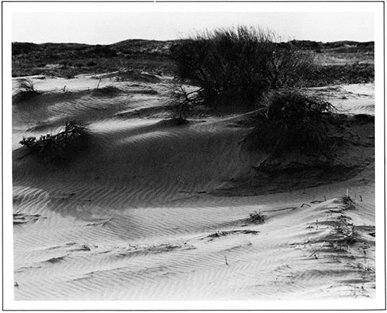
Dune Sand near the Arkansas River in Hamilton County.
Many geologists class the time in which we are now living as part of the Pleistocene Epoch because the climate is still relatively cold. The time to the present since the last ice sheet melted from the northern part of the United States is probably less than 25,000 years. This period is marked by conditions as we know them today, including the erosion or deposition of sands and gravels along river valleys, the formation of sand dunes, and the deposition of dust or loess by the wind. During this time, more erosion of the land surface has taken place than deposition because the main geologic forces that are active today in Kansas are those that are wearing away the older rocks.
The geologic history of Kansas, then, is largely an alternation of more or less prolonged times of sedimentary deposition and times of erosion, during which varying volumes of previously formed rocks were destroyed. What effect did this succession of geologic events have on the surface of Kansas as we know it today?
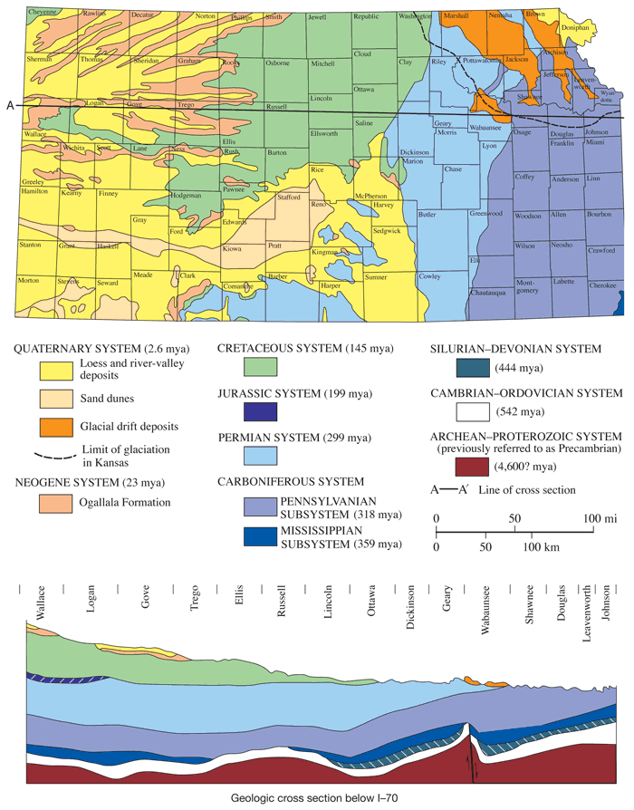
First, nearly all the rocks at the surface of Kansas are sedimentary in origin. Except for a couple of small localities in Riley and Woodson counties, the only igneous and metamorphic rocks at the surface of Kansas have been brought in from outside the state. Glaciers, for example, hauled in the metamorphic rocks found in northeastern Kansas. Second, the rocks at the surface of Kansas are progressively younger as you move from east to west across the state. Younger sediments have deeply buried the older rocks in western Kansas, but those same sediments were either eroded away or were never deposited in eastern Kansas.
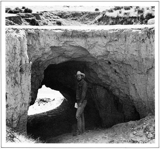
Loess Forms a Natural Bridge in Cheyenne County.
Also, the rock layers are not perfectly flat-lying, but have been tilted slightly and eroded, so that some of the older rocks can be seen at the surface. Gentle deformation has caused rocks of different ages to crop out in the various parts of the state. The older rocks, those of Cretaceous age and earlier, have been tilted and the younger rocks have been eroded or worn from above them. Thus the Mississippian and Pennsylvanian rocks occupy the eastern quarter of Kansas. The rocks of Permian age (next younger than Pennsylvanian) crop out in a north-south belt across central Kansas, and the Cretaceous and Tertiary rocks are found farther west. The indentations made by valleys that have been cut into the rocks make the pattern of the outcrops irregular. In the northeastern corner of the state, evidence of the southern border of the glaciers may be seen, although most Pleistocene deposits are not shown on the map because they are so thin and widespread.
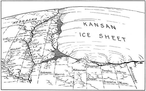
The Kansan ice sheet was a glacier that extended into Kansas approximately a million years ago. This map, by former Survey director R. C. Moore, shows the approximate southern limit of the glacier, which carried quartzite boulders and glacial till into northeastern Kansas.
The map indicates the age of the rocks at the surface of each county. If you live in the western part of the state, you will be most interested in rocks and minerals described as occurring in the Tertiary and Upper Cretaceous deposits. If you live in eastern Kansas, the rocks of Pennsylvanian age will interest you. If the central part of the state is your home, you can expect to find rocks and minerals of Permian and Cretaceous age.
Generalized Geologic Map and Cross Section of Kansas.
The earth is 4.5 billion years old, but people have lived in Kansas only a few thousand years and have studied its geology for less than 150 years. Much is still to be learned. Geologists are only now beginning to sort out the early geologic history of the state, a time more than a billion years ago when the state was being pulled apart by continental plates and molten rock flowed onto the earth's surface. Geologists are still learning the extent of economic minerals such as oil and gas. They are only now making detailed studies of Kansas earthquakes, and they are occasionally surprised by the discovery of previously unexpected minerals. Yet in spite of the limits of knowledge, geologists know much about the origin of rocks in the state and their economic potential. The following sections provide an introduction to that knowledge of the state's rocks and minerals.
Prev Page--Contents || Next Page--Kansas Rocks
Kansas Geological Survey
Placed on web Feb. 28, 2017; originally revised and reprinted 1998.
Comments to webadmin@kgs.ku.edu
The URL for this page is http://www.kgs.ku.edu/Publications/Bulletins/ED2/02_hist.html