![]()
Prev Page--Geography || Next Page--Ground water
Geology
Summary of Stratigraphy*
* The stratigraphic classification used in this report is that of the State Geological Survey of Kansas and dillers somewhat from that of the United States Geological Survey.
The rocks that crop out in the area discussed in this report are sedimentary and range in age from Cretaceous (Gulfian) to Recent. A generalized section of the geologic formations is given in Table 3, their areal distribution is shown on Plate 1, and their stratigraphic relationship is shown on Plate 3.
Table 3--Generalized section of geologic formations and their water-bearing properties.
| System | Series | Formation | Thickness, feet |
Character | Water supply |
|---|---|---|---|---|---|
| Quaternary | Pleistocene* | Recent alluvium | 0-40 | Sand, gravel, silt, and clay; stratified or cross-bedded, and unconsolidated; well-sorted only in major valleys. | Yields abundant supplies of water to wells along North Solomon River, smaller supplies along tributaries. |
| Terrace deposits | 0-90 | Silt and clay. stratified; contains soil zones in upper part. Lower part consists of sand and gravel containing silt lenses. | Yields moderate supplies of water to wells except where lower sand and gravel is absent. | ||
| Sanborn formation* | 0-70 | Silt, massive, well-sorted, light-gray, tan, and reddish-tan; contains one widespread and one local buried soil zone. Locally, lower part consists of well-sorted sand grading into sand and gravel (Crete member). | Basal sand and gravel yields moderate supplies of water to wells where it occurs below the water table. | ||
| Meade formation* | 0-40 | Sand, gravel, and silt; cross-bedded and stratified. | Yields moderate supplies of water locally where below water table. | ||
| Tertiary | Pliocene | Ogallala formation | 0-30± | Sand, gravel, and silt; gray and greenish-gray; locally, cemented with opal or calcium carbonate. | Occurs above the water table; yields no water to wells in this area. |
| Cretaceous | Gulfian* | Niobrara formation | 600± | Chalk and chalky shale: contains 50 feet of chalky limestone at base (Fort Hays limestone member). | May yield small quantities of water occasionaly from fractures or joints. |
| Carlile shale | 300 | Shale, fissile, noncalcareous, lead-gray, and chalky gray shale; contains thin lenses of fine-grained sandstone (Codell) at top, calcareous concretions in upper part, and thin limestone and bentonite beds in base. | Yields little or no water to wells in this area. | ||
| Greenhorn limestone | 85 | Shale, chalky, gray, alternating with thin chalky limestones In upper part and thin petroliferous limestones in base. Only upper 20 feet exposed in area. | Yields little or no water to wells in this area. | ||
| Graneros shale | 30± | Shale. fissile, noncalcareous, gray to black; contains selenite crystals, lenticular sandstones, and "Ironstones." Not exposed in this area. | Yields little or no water to wells in this area. | ||
| Dakota formation | 200± | Clay, gray, white, and buff shale, lenticular sandstone. and bed. of lime-cemented sand: contains Iignite and siderite pellets. Not exposed in this area. | Yields moderate quantities of highly mineralized water under artesian pressure to deep wells. | ||
| * Classification of the State Geological Survey of Kansas. | |||||
The oldest rocks exposed in this area are marine Cretaceous rocks and are represented by the Greenhorn limestone, the Carlile shale, and the Niobrara formation. Underlying these rocks and cropping out a few miles to the east are the Graneros shale and the Dakota formation (Moore and Landes, 1937). At the extreme western end of this area, the divides north and south of Solomon River are capped by remnants of the Ogallala formation of Pliocene age. The eolian silts that make up the Sanborn formation are widely distributed over the uplands and valley walls of north-central Kansas. Along the major streams, these silts may be underlain by stream-deposited sands which are in a high-terrace position with respect to the valleys and which locally are important sources of ground water. Along North Solomon River and many of its tributaries are terrace deposits laid down by these streams in an earlier aggradational cycle. Narrow belts of alluvium are adjacent to the river channel and its tributaries. Most of the alluvium is of Recent age, and deposition of this material by the streams is still in progress. In local areas on the Hood plain of North Solomon River, modern winds have formed dunes from the alluvial sand (Pl. 4D). In other places, sand has drifted and modified the terrace surface (A-A', Pl. 3).
Geology in Relation to Ground Water
Cretaceous System (Gulfian Series)
Dakota Formation
The Dakota formation does not crop out in this area and no wells in the North Solomon Valley are known to obtain water from it. This formation, however, contains lenticular sand bodies, which are sources of potable water in parts of central Kansas (Frye and Brazil, 1943; Moore and others, 1951). Several attempts to obtain water from the Dakota formation have been made in this area, but only salt water has been found.
Character--The Dakota formation was named by Meek and Hayden (1862) from an exposure near Dakota City in northeastern Nebraska. In that area, as along the outcrop in central Kansas, the Dakota consists of clay, sandstone, and lignite. In 1930 Landes (pp. 30, 49-50) described the upper part of the Dakota along the Solomon Valley in eastern Mitchell County and discussed the occurrence of ground water in this formation. A detailed study of the stratigraphy and lithology of the Dakota in its outcrop area was made by Plummer and Romary (1942), and Landes and Keroher (1942, p. 299) discussed the character of the formation in the subsurface of Phillips County.
Plummer and Romary have shown that in Kansas the Dakota consists predominantly of shale, clay, and siltstone 100 to 275 feet in thickness. Lentils of fine-grained sandstone may occur at any horizon in the formation, and lignite, hematite, and siderite are present locally. Many of the sandstone lentils probably are interconnected and some water-bearing sandstone is present at most locations. Along the outcrop in northern Kansas, the Dakota is the basal unit of the Cretaceous System, lying nonconformably on Permian redbeds, but toward the west, lower Cretaceous (Comanchean) rocks underlie this formation (Landes and Keroher, 1942). It is overlain conformably by the Graneros shale and other upper Cretaceous marine rocks. The top of the Dakota lies at a depth of about 100 feet near Downs, at about 450 feet at Kirwin, and at more than 800 feet near Logan.
Water supply--Oil and gas test holes that have penetrated the Dakota formation in Phillips County and the few water wells that have been drilled in this area indicate that the sandstones in the Dakota formation contain moderate supplies of water under artesian pressure. The water is so highly mineralized, however, that it is unfit for domestic, stock, or irrigation use. Logan (1897, p. 209) referred to a zone of saliferous shales in the upper part of the Dakota formation, and Darton (1905, pp. 307-311) attributed the salt water in the sandstone lentils to this material. In Ellis and Russell Counties Frye and Brazil (1943) found evidence that water in the Dakota was more mineralized where the rocks were more deeply buried. Landes (1930) stated that water in the Dakota formation in northern Mitchell County and in Osborne County was too highly mineralized for domestic use; this statement seems to be true also for the parts of the North Solomon Valley in Phillips and Smith Counties.
Graneros Shale
Character--Gilbert (1896) named the Graneros shale from exposures of noncalcareous marine shale along Graneros Creek about 20 miles south of Pueblo, Colorado. In central Kansas, the name Graneros is applied to the non calcareous shale at the base of the group of beds formerly referred to as "Benton" (Logan, 1897). It consists of about 30 feet of gray to black fissile shale (Landes, 1930, p. 30; Plummer and Romary, 1942, pp. 328-331) and contains selenite crystals, thin bentonite partings, and sandstone lentils. The Graneros shale lies conformably on the Dakota formation and is overlain conformably by the Greenhorn limestone. The shale does not crop out in the area studied.
Water supply--The Graneros shale is not known to furnish water to any wells in this part of Kansas. In surface exposures near the area the sandstones are similar in character to those in the Dakota and they probably have similar water-bearing properties.
Greenhorn Limestone
Character--The Greenhorn limestone was named by Gilbert ( 1896) from exposures of interbedded limestone and calcareous shale near Greenhorn Station, about 15 miles south of Pueblo, Colorado. In Kansas the Greenhorn limestone consists of the series of chalky limestones, calcareous shales, and bentonite between the Carlile shale and the noncalcareous shale of the Graneros. Landes (1930, p. 23) gives the total thickness of the Greenhorn in Mitchell County as 82 feet. Only the upper 20 feet is exposed in the area studied, but the entire section is exposed farther east along Solomon River. In Mitchell County (Landes, 1930, pp. 13, 23-30) the formation has been divided into four members, including the Pfeifer shale at the top, the Jetmore chalk, the Hartland shale, and the Lincoln limestone. The upper layer is the Fencepost limestone bed, which is about 0.8 foot thick and which has been quarried extensively for fence posts and for building stone in north-central Kansas. In Mitchell County the Fencepost bed is massive, contains Inoceramus shells, and has an iron-stained band in its center. The remainder of the Pfeifer member consists of calcareous shales separated by thin concretionary limestones.
| Section of the Greenhorn limestone and overlying Carlile shale measured along small creek in the SW sec. 32, T. 6 S., R. 10 W., Mitchell County (Measured by A. R. Leonard and J. B. Cooper, 1946) | Thickness, feet |
||||
|---|---|---|---|---|---|
| Cretaceous--Gulfian | |||||
| Carlile shale--Fairport chalky shale member | |||||
| 13. | Limestone, crystalline, composed of flat discoidal concretions | 0.4 | |||
| 12. | Shale, calcareous, light gray-buff | 1.4 | |||
| 11. | Limestone, thin persistent, crystalline; has limonite stains | 0.2 | |||
| 10. | Shale, calcareous, tan-buff | 1.35 | |||
| 9. | Limestone, crystalline, persistent; has limonite stains | 0.15 | |||
| 8. | Shale, calcareous, buff | 0.85 | |||
| Total Carlile shale exposed | 4.35 | ||||
| Greenhorn limestone | |||||
| Pfeifer shale member | |||||
| 7. | Limestone (Fencepost), dense; contains shells, iron-stained band in center | 0.5-0.65 | |||
| 6. | Shale, fossiliferous, light gray-black; weathers whitish; contains calcite crystals. Shale has a 0.3-foot concretionary limestone bed 2 feet above base and a 0.15-foot concretionary bed 1 foot from top | 5.0 | |||
| 5. | Limestone, crystalline, light gray-pink; weathers yellowish | 0.4 | |||
| 4. | Shale, fossiliferous, calcareous, dark-gray; weathers bluegray; contains several discoidal limestone concretionary beds up to 0.4 foot in thickness | 6.0 | |||
| 3. | Limestone, dense, hard, persistent; abundantly fossiliferous | 0.2 | |||
| 2. | Shale, fissile, calcareous, dark tan-buff to dark-gray; contains several zones of discoidal concretionary limestones with abundant fossils | 5.7 | |||
| Total thickness, Pfeifer member | 17.9 | ||||
| Jetmore chalk member | |||||
| 1. | Limestone ("shell bed"), dense, resistant, very fossiliferous; has irregular shale parting in center | 1.0 | |||
| Total section measured | 23.3 | ||||
Water supply--The shales and chalky limestones that make up the Greenhorn are impervious and do not yield water to wells in this area. Under favorable conditions, the upper chalky part of the formation might weather deeply and store meager quantities of water. In all localities along Solomon Valley where deep weathering might have occurred, the Greenhorn lies above the water table.
Carlile Shale
Character--The Carlile shale was named by Gilbert (1896) from exposures along Arkansas River near Carlile Station, 21 miles west of Pueblo, Colorado. He described it as a gray argillaceous shale, 175 to 200 feet thick, containing sand and calcareous concretions. Logan (1897, pp. 232-234) compared the upper part of the "Benton" with Gilbert's section and later (1899) made the correlation more definite. Rubey and Bass (1925, pp. 32-45) formally divided the Carlile shale into members, applying Logan's term "Blue Hill" to the upper argillaceous member and naming the lower zone of calcareous shales and thin chalky limestones the Fairport shale member. Bass (1926, p. 28) named and described the Codell sandstone zone, in the upper part of the Blue Hill shale member, from exposures along Saline River in northern Ellis County. Landes (1930, pp. 19-23) recognized the Fairport, Blue Hill, and Codell in Mitchell and Osborne Counties, and Landes and Keroher (1942) noted the upper part of the Carlile shale in the Solomon Valley near Glade, where it arches across the top of the Stockton anticline.
The Carlile shale consists of about 300 feet of argillaceous and chalky shale between the top of the Fencepost bed of the Greenhorn limestone, and the base of the Niobrara formation. The Fairport chalky shale member, at the base of the Carlile shale, consists of alternating light-gray to buff carcareous shale and thin chalky limestones, and contains thin persistent bentonite seams. The limestones are generally white or pink and those in the lower part of the member are concretionary, like those in the upper part of the Greenhorn limestone. In fresh exposures the shale of the Fairport member is fissile and light gray, flecked with minute particles of white calcite. The shale weathers to form a bright-yellow clay soil. Ostrea shells are common in the Fairport member and early geologists referred to these beds as the "Ostrea shales" (Logan, 1897, pp.217-218). In Osborne County the total thickness of the Fairport shale member is about 100 feet (Landes, 1930, p. 21).
Plate 6--A, Fort Hays limestone member, Codell sandstone zone, and Blue Hill shale member in road cut, NE sec. 17, T. 6 S., R. 13 W., Osborne County. Hammer head marks contact of Codell and Fort Hays. B, Crete sand and gravel member overlying thin-bedded Blue Hill shale member in bank of North Solomon River, SW NW sec. 26, T. 5 S., R. 13 W., Smith County. C, Close-up of Blue Hill shale member (above) showing flat discoidal concretions.
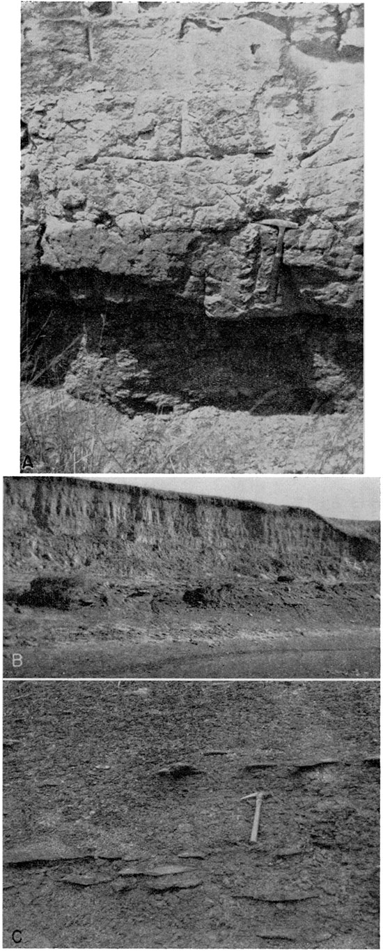
The 200 feet of fissile noncalcareous black to blue-gray shale conformably overlying the Fairport member constitutes the Blue Hill shale member. Sandstone and sandy shale occurring in the upper 30 feet make up the Codell sandstone zone. In southwestern Osborne County (Landes, 1930, p. 30) and southern Rooks County (Bass, 1926, pp. 27-28), the Codell is about 30 feet thick. Northwest of Osborne and along the North Solomon Valley in southwestern Smith County, the Codell is only 1 to 2 feet thick and consists of fine-grained sand loosely cemented with limonite (Pl. 6A). Locally, fossil shark teeth or vertebrae are present in the Codell sandstone zone. Numerous zones of calcareous septarian and ordinary concretions are found in the Blue Hill member (Pl. 7B ). The septaria are roughly spherical, discoidal, or lemonshaped, and contain cross-cutting veins of dark-brown calcite which weather in relief. They range from a few inches to 8 feet in diameter and are found in layers that form slight benches on the steep slopes below the Fort Hays escarpment. Several zones of brown Hat discoidal concretions in the lower part of the Blue Hill shale member are exposed in the bank of North Solomon River in the NE sec. 27, T. 5 S., R. 13 W. (Pl. 6B, 6C). Many of these are weathered and reveal the nacreous shells of mollusks. Thin layers of ocher and layers of diamond-shaped selenite crystals also are found in the Blue Hill shale member. The shale erodes easily and is not well exposed except on steep slopes below the Fort Hays escarpment, where it forms small badlands. A typical section of the upper part of the Blue Hill shale member is given below.
| Measured section of upper Carlile shale in SE sec. 3, T. 7 S., R. 13 W., Osborne County, Kansas | Thickness, feet |
|||
|---|---|---|---|---|
| Cretaceous--Gulfian | ||||
| Niobrara formation--Fort Hays limestone member | ||||
| Massive chalky limestone | ||||
| Carlile shale--Blue Hill shale member | ||||
| 14. | Sandstone (Codell), fine- to very fine-grained, contains limonite | 1.0 | ||
| 13. | Shale, massive, silty, noncalcareous, light-gray | 3.0 | ||
| 12. | Shale, fissile, dark gray-black; contains layers of selenite crystals and limonite bands | 11.0 | ||
| 11. | Shale, light-gray to rusty-buff; less fissile than shale above; contains rusty and sulfur-yellow streaks | 15.0 | ||
| 10. | Sandstone, very fine-grained, argillaceous, rusty | 0.05 | ||
| 9. | Shale, fissile, dark-gray to black; contains streaks of limonite and ocher | 1.0 | ||
| 8. | Sand, very fine-grained, rusty | 0.1 | ||
| 7. | Shale, fissile, black | 1.5 | ||
| 6. | Sandstone, very fine-grained, hard, dense, calcareous; lenses out in short distance | 1.5 | ||
| 5. | Shale, fissile, noncalcareous, black | 1.0 | ||
| 4. | Concretionary zone, giant brown sugar-textured calcareous concretions | 3.0 | ||
| 3. | Shale, fissile, black; has rusty limonitic streaks | 6.0 | ||
| 2. | Concretionary zone, giant brown calcareous concretions | 3.0 | ||
| 1. | Shale, fissile, noncalcareous, black; has limonitic streaks | 7.0 | ||
| Total exposed Carlile shale | 54.15+ | |||
Water supply--The shales of the Carlile are impervious and do not yield water to wells in this area. Adjacent to the North Solomon Valley the Codell sandstone is thin and is not a source of water, but in southeastern Norton County (Frye and Leonard, 1949, p. 27) and in southwestern Osborne County (Landes, 1930, p. 49) it yields water to wells.
Niobrara Formation
Character--In 1862 Meek and Hayden named the Niobrara formation from exposures of calcareous marl and chalky limestone near the mouth of Niobrara River in northeastern Nebraska. In 1897 Logan (pp. 219-221, 228, 234) described the Niobrara of north-central Kansas and subdivided it into the Fort Hays limestone and Smoky Hill chalk or Pteranodon beds. He described a section of the Cretaceous beds along Solomon River from Beloit into Norton County, which shows the interrelation of the Cretaceous units (Logan, 1897, pl. 30, fig. 2). Williston (1897, pp. 235-246) discussed the paleontology and stratigraphy of the Niobrara in western Kansas. Landes (1930, pp. 16-18) described the occurrence and appearance of the lower part of the formation in Osborne County.
Although the Niobrara probably is 650 feet thick in Phillips County (Landes and Keroher, 1942, p. 286), only the lower 300 or 400 feet is exposed in this area. The lower 45 to 50 feet, the Fort Hays limestone member, consists of massive white chalk beds 3 to 5 feet thick separated by thin partings of gray chalky shale. The Fort Hays limestone member is more resistant to erosion than the overlying Smoky Hill chalk member or the underlying Carlile shale, and it commonly forms a prominent escarpment where the beds are well exposed in quarries and road cuts. The following section in a road cut and quarry along Kansas Highway 9 illustrates the character of the member.
| Measured section of the Fort Hays limestone member of the Niobrara formation at SW cor. SW NW sec. 36, T. 4 S., R. 15 W., Smith County, Kansas (Measured by A. R. Leonard and Ira Dubins, April 1947) | Thickness, feet |
||||
|---|---|---|---|---|---|
| Cretaceous--Gulfian | |||||
| Niobrara formation | |||||
| Smoky Hill chalk member | |||||
| 35. | Limestone, soft, chalky, buff to white | 0.5 | |||
| 34. | Shale, chalky, yellow | 0.25 | |||
| 33. | Limestone, soft, chalky, white | 0.5 | |||
| Fort Hays limestone member | |||||
| 32. | Shale, fissile, calcareous, gray with orange streaks | 0.3 | |||
| 31. | Limestone, massive, chalky; has parting plane 0.8 foot base; increases in thickness to the east | 3.4 | |||
| 30. | Shale gray | 0.05 | |||
| 29. | Limestone, chalky; thickness varies; averages | 0.8 | |||
| 28. | Shale, fissile, calcareous, gray and orange | 0.6 | |||
| 27. | Limestone, chalky, massive; irregular parting 2.2 feet above base | 3.4 | |||
| 26. | Shale parting, chalky, gray | 0.08 | |||
| 25. | Limestone, chalky, massive, white; contains indistinct parting 1.2 feet below top, and pyrite concretions and manganese dioxide stains. Thickens toward east | 4.1 | |||
| 24. | Shale, chalky, yellow-banded | 0.3 | |||
| 23. | Limestone, massive, chalky; contains pyrite concretions and a black-stained band 1.3 feet above base | 2.1 | |||
| 22. | Shale, calcareous, yellowish | 0.08 | |||
| 21. | Limestone, chalky | 1.1 | |||
| 20. | Shale, chalky, fissile, yellow | 0.12 | |||
| 19. | Limestone, chalky, white | 0.75 | |||
| 18. | Shale, chalky, fissile, yellow | 0.04 | |||
| 17. | Limestone, chalky, massive, yellow. Lower 0.4 foot more resistant to weathering than upper part | 2.4 | |||
| 16. | Shale, calcareous | 0.1 | |||
| 15. | Limestone, chalky | 2.3 | |||
| 14. | Shale, calcareous | 0.06 | |||
| 13. | Limestone, chalky | 2.2 | |||
| 12. | Shale, calcareous, fissile, gray-buff | 0.08 | |||
| 11. | Limestone, chalky | 1.5 | |||
| 10. | Shale, calcareous, buff; upper part fissile, lower part chalky | 0.5 | |||
| 9. | Limestone, chalky | 3.0 | |||
| 8. | Shale, chalky | 0.4 | |||
| 7. | Limestone, chalky, massive, light-colored | 1.6 | |||
| 6. | Shale, calcareous, buff | 0.25 | |||
| 5. | Limestone, chalky; indistinct shale parting at base | 0.8 | |||
| 4. | Limestone, chalky; whiter than bed no. 2 | 2.0 | |||
| 3. | Shale parting | 0.15 | |||
| 2. | Limestone, massive, chalky, yellowish; surface stained with limonite; contains pyrite concretions | 3.6 | |||
| 1. | Limestone, massive, chalky, yellowish; contains a little sand in lower part and indistinct shale parting at top | 5.4 | |||
| Carlile shale--Blue Hill shale member | |||||
| Total measured section | 44.81 | ||||
The upper part of the Niobrara formation, the Smoky Hill chalk member, consists of chalky shale beds which are blue-gray when fresh and yellowish buff, bright yellow, or orange when weathered. Locally, the member contains massive beds of chalk that resemble the underlying Fort Hays limestone member, and thin bentonite beds occur in many stratigraphic positions. Large fossil shells of Inoceramus grandis and small Ostrea congesta shells are abundant in the chalk beds, and concretions of pyrite and limonite are present. The Smoky Hill chalk member has eroded into the rounded promontories along North Solomon River in Phillips County and in western Smith County (Pl. 4B) and elsewhere has eroded into badlands or weird erosional features. Many exposures of the member contain nearly vertical fractures that are filled with pure white crystalline calcite. Along some of these fractures, slippage caused by surficial slumping has displaced the chalk beds slightly and has slickensided the calcite fillings.
Water supply--In general, the chalk and chalky limestone beds of the Niobrara formation are impervious and do not yield water to wells. The Fort Hays limestone member breaks into platy fragments and becomes jointed and fractured upon weathering (Pl. 7A). These joints and fractures and the fractures in the Smoky Hill chalk member may permit the infiltration and movement of small quantities of water into the formation. In most places, weathering does not extend below the water table, and only small zones of perched water are found in the Niobrara. Well 5-16-3bc is the only well in this area known to obtain water from the Niobrara formation.
Plate 7--A, Fort Hays limestone member of the Niobrara formation showing jointing and typical weathering near surface; NE sec. 3, T. 5 S., R. 13 W., Smith County. B, Large septarian concretion weathered from Blue Hill shale; NE sec. 25, T. 5 S., R. 13 W., Smith County.
Tertiary System (Pliocene Series)
Ogallala Formation
Darton named the Ogallala formation in 1899 (pp. 734-742) from a locality in southwestern Nebraska that he later referred to as near Ogallala Station. Elias (1931) made a detailed study of the Ogallala in the western part of Kansas and later (1942) described fossil seeds from the formation. The present usage of the State Geological Survey of Kansas is to classify the Ogallala as a formation composed of the Valentine, Ash Hollow, and Kimball members (Frye and Leonard, 1949, p. 38).
Only the lower 30 feet of the Ogallala formation is present along the sides of the North Solomon Valley in western Phillips County, where it lies above the water table. In this area, the Ogallala formation consists largely of sand, silt, gravel, and clay and is locally cemented with silica or calcium carbonate. The silica-cemented lentils of sand and gravel form resistant ledges of dense green "quartzite," which make prominent benches along the sides of the valley near Logan and cap the hills along the North Solomon-Bow Creek divide as far east as Glade. The following measured section illustrates the formation in this area.
| Measured section of Ogallala formation in the SW sec. 13, T. 5 S., R. 19 W., Phillips County (Measured by John C. Frye, Ada Swineford, and Alvin R. Leonard) | Thickness, feet |
|||
|---|---|---|---|---|
| Quaternary--Pleistocene | ||||
| 12. | Silt and sand, tan | 8.0 | ||
| Tertiary-Pliocene | ||||
| Ogallala formation | ||||
| 11. | Quartzite, fine-grained, dense, green | 1.5 | ||
| 10. | Sand, massive, green and red; contains fragmentary Mastodon tooth | 5.0 | ||
| 9. | Quartzite, fine-grained, fairly well cemented, green | 1.0 | ||
| 8. | Sand and silt, massive, green, spotted and streaked with calcium carbonate | 3.0 | ||
| 7. | Silt and sand, massive, partly silicified, hard, light-gray | 1.5 | ||
| 6. | Sand, silty, massive, tightly cemented with calcium carbonate; weathers to a deeply etched surface of vertical columns and horizontal sheets | 1.0 | ||
| 5. | Sand, fine, and silt, green; speckled with calcium carbonate | 2.5 | ||
| 4. | Quartzite, fine-grained, lenticular, light-green | 1.5 | ||
| 3. | Silt and fine sand, partly covered, light greenish-gray, weathers to ash-gray; contains few nodules of calcium carbonate | 2.5 | ||
| 2. | Sand, fine and silt, indistinct bedding, very light greenish-gray, weathers to platy and nodular surface; loosely cemented throughout with calcium carbonate; forms indistinct bench along near-by canyon side | 4.5 | ||
| 1. | Silt, sandy, calcareous; contains calcium carbonate in irregular nodules and stringers; upper part more clayey, darker gray, contains less carbonate | 6.0 | ||
| Total section measured | 38.0 | |||
Quaternary System (Pleistocene Series)
The unconsolidated deposits of Quaternary age are the most important water-bearing rocks in this area. They are the surficial rocks over the greater part of the mapped area (Pl. 1) and are the source of virtually all water supplies of the valley area. Under the classification system used in this report (that of the State Geological Survey of Kansas), the Pleistocene Series includes the entire Quaternary System. The Pleistocene deposits in the area covered by this report are the Meade formation, Sanborn formation, terrace deposits, and alluvium. The Meade does not crop out in this area; the areal distribution of the other formations is shown on Plate 1. The relation of these rocks to each other and to the Cretaceous bedrock formations is shown on Plate 3.
Meade Formation
Character--Deposits classed as Meade formation are found south of North Solomon River southwest of Portis, north of the river east of Harlan, and north of Cedar Creek in western Smith County. These beds are remnants of stream deposits of an ancestral phase of North Solomon River and have a high terrace relation to the modern valley. Other remnants of stream deposits which cap the hills north and south of Downs have a similar topographic position and relation to younger beds and may also be Meade formation. Some of the high terrace sand and gravel underlying the silts of the Sanborn formation in western Phillips County may belong to the Meade formation instead of to the Crete sand and gravel member of the Sanborn as indicated on Plate 3. The Meade has not been recognized in that area, but it is known to be present along the North Solomon Valley in southern Norton County. In northern Osborne County (Pl. 8) the Meade consists of coarse crossbedded gravel that grades upward into sand overlain by silt and sandy silt containing fossil snails, which were identified by A. B. Leonard (personal communication) as diagnostic of the Sappa member of the Meade formation.
| Measured section of Pleistocene deposits in a gravel pit in the NW sec. 11, T. 6 S., R. 13 W., Osborne County | Thickness, feet |
|||
|---|---|---|---|---|
| Quaternary--Pleistocene | ||||
| 5. | Colluvium; gravel, clay, and silt, intermixed and overlain by red-brown silt to top of vertical cut | 6.0 | ||
| Meade formation | ||||
| 4. | Silt and clay, massive, calcareous, gray; contains snails; upper part leached, blocky clay resembling the lower part of a soil profile. Beveled to the north and overlain uncomfortably to the south by colluvium | 1.5 | ||
| 3. | Clay, silty, jointed, hard, gray-green; contains abundant snails of Yarmouthian age | 3.5 | ||
| 2. | Sand, silty, poorly stratified, hard, gray; contains snail and clam shells | 1.8 | ||
| 1. | Gravel, cross-bedded, coarse at base, grading upward into sand and gravel; contains much local material. To base of gravel pit | 16.0 | ||
| Total section measured | 28.8 | |||
Frye, Swineford, and Leonard (1948) correlated the Meade formation from the type locality over a wide area in Kansas and the Great Plains and showed the formation to be of Kansan age. Deposits of Pearlette volcanic ash are exposed near Kensington in Smith County and along Bow Creek in southwestern Phillips County. These deposits may be continuous with the Meade deposits along North Solomon River and form an integrated drainage pattern of Kansan age.
Except in artificial cuts for highways and gravel pits, the Meade formation does not crop out in this area, but its character and relation to younger deposits have been determined from several test holes. The Meade has been mapped (Pl. 1) with the overlying Sanborn formation.
Water supply--Most of the Meade deposits in this area are of small extent and lie above the water table. North of Cedar Creek in Smith County and southwest of Portis in Osborne County, these deposits are of sufficient lateral extent to serve as local acquifers; however, only one well (4-14-28cb) obtaining water from these deposits was inventoried during this investigation. The relation of the Meade formation to the adjacent Crete deposits suggests that water moves from the higher Meade into the Crete, then into and through the terrace deposits, and into the channel of North Solomon River (Pl. 3).
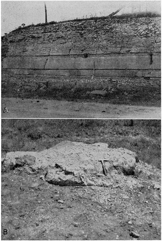
Plate 8--Meade formation in gravel pit in the NW sec. 11, T. 6 S., R. 13 W. A, Close-up of silt in the upper part of the Meade formation overlain by colluvium. Crumby-textured deposit below hammer is pond silt containing snails. B, Silt of the Meade formation overlying cross-bedded gravel. Man's hand indicates top of silt beneath colluvium. C, Close-up view of cross-bedded gravel in lower part of the Meade formation.
Sanborn Formation
Character--Elias (1931, pp. 163-180) noted thick deposits of silt and other unconsolidated Pleistocene material in northwestern Kansas and named these deposits the Sanborn formation from a locality in northwestern Cheyenne County, Kansas, south of the town of Sanborn, Nebraska. Later studies by Frye and others have shown that the Sanborn in most of north-central Kansas consists of winddeposited silt or loess. In 1947, Frye and Fent divided the formation into several members, in ascending order: Loveland silt, Peoria silt, and Bignell silt. This classification was modified in Norton County by Frye and Leonard (1949) who applied the name Crete to the sand and gravel member which underlies the Loveland silt, forms a high terrace in this area, and is overlain by the younger silts. All four subdivisions have been recognized in this area and the fourfold classification will be used in this report.
The oldest deposit of the Sanborn formation in this area is the Crete sand and gravel member, which represents channel fills of Illinoian age (Pl. 9C). During the time when these beds were being formed, the ancestral North Solomon River followed a course parallel to the present valley. Crete deposits consist of stream-deposited coarse sand and fine gravel from 30 to 50 feet thick, which form a high terrace above the present stream. These deposits grade upward into sandy and poorly stratified silt, classed as Loveland silt member, which grades laterally into eolian silt mantling the upland surface.
| Measured section of the Crete and Loveland members of the Sanbom formation in the SE sec. 26, T. 4 S., R. 14 W., Smith County | Thickness, feet |
||||
|---|---|---|---|---|---|
| Quaternary--Pleistocene | |||||
| Sanborn formation | |||||
| Loveland silt member | |||||
| 6. | Silt, sandy, light-gray, weathers whitish gray; contains more sand near base; upper 2 feet is darker "soil zone" which forms "high terrace" surface | 15.0 | |||
| 5. | Silt and fine sand, reddish-buff | 6.0 | |||
| 4. | Sand, silty, very fine, light-buff; contains thin lenses of silty clay | 7.5 | |||
| Crete sand and gravel member (?) | |||||
| 3. | Sand, fine, silty, with stringers of clay and fine gravel; contains small snail shells | 7.0 | |||
| 2. | Clay, silty, buff, lenticular; average thickness | 0.7 | |||
| 1. | Sand, fine; contains stringers of fine chalk pebbles and silt; base at level of Beaver Creek Hood plain | 3.5 | |||
| Total section measured | 39.7 | ||||
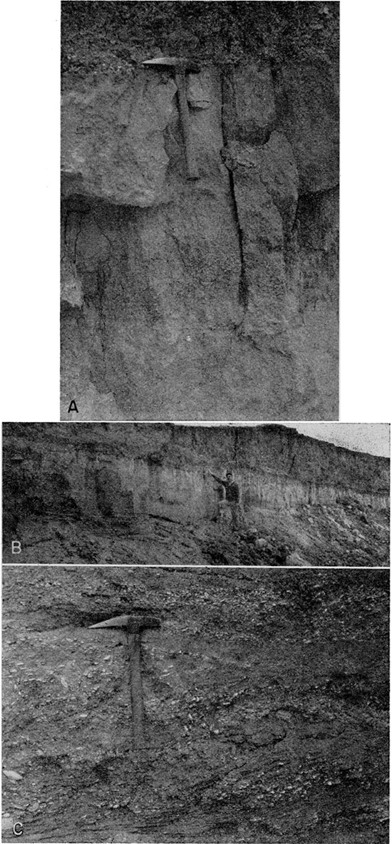
Plate 9--Deposits of the Sanborn formation. A, Soil zone of the Loveland silt member of the Sanborn formation in plowed field in the SM sec. 20, T. 4 S .. R. 16 W., Phillips County. B, Bignell silt, Brady soil, and Peoria silt in road cut in the SW sec. 24, T. 4 S., R. 19 W., Phillips County. C, Crossbedded sand and gravel of the Crete member in river bank in the SW NM sec. 26, T. 5 S., R. 13 W., Smith County.
The Loveland silt member may be from 10 to 20 feet thick along the valley margins where it overlies the Crete member, but it is generally less than 10 feet thick where it overlies Cretaceous rocks in the upland areas. The Loveland is composed of fine-grained slightly calcareous well-sorted silt, and contains a well-developed fossil soil profile at the top. This soil is well exposed in road cuts and in freshly plowed fields adjacent to the valley (Pl. 9A). It may be as much as 3 feet thick; the upper part contains organic material and is dark brown. The lower part of the soil profile contains an accumulation of clay and has a prominent red color, which may extend all the way through the member. In many places caliche nodules are concentrated below the base of the soil zone.
The upper part of the soil zone grades into the overlying Peoria silt member. This member has been widely correlated in Kansas, Nebraska, and Iowa with deposits of early Wisconsinan (Iowan) age in the glaciated area. Swineford and Frye (1951) have shown that the Hood plains of Platte and Republican Rivers are the source areas for the Peoria loess. Large quantities of fine material accumulated on the Hood plains of these glacier-fed streams and were carried over a large area of the High Plains by strong northwesterly winds. In the North Solomon Valley area, the Peoria member is represented by about 15 feet of yellowish-gray well-sorted calcareous silt which extends in an almost unbroken blanket over the upland and overlaps the lower-lying terraces developed on Meade and Crete deposits. In many localities along the larger tributary streams, erosion has removed the entire thickness of Peoria silt, has cut through the Loveland soil, and has exposed the underlying Loveland silt member.
In general, the Peoria silt member is the youngest deposit on the upland bordering the North Solomon Valley. At a few localities, the top of the Peoria member is marked by a moderately developed fossil soil (Brady soil) and is overlain by as much as 5 feet of gray silt, the Bignell silt member. The only locality where the Bignell was observed in the mapped area (Pl. 1) is just north of Speed, in Phillips County. At this locality, about 5 feet of light-gray silt overlies a well-developed soil zone at the top of the Peoria silt. The upper part of the following section of Pleistocene deposits is shown in Plate 9B.
| Measured section of Pleistocene deposits in the SW SW sec. 24, T. 4 S., R. 19 W., Phillips County | Thickness, feet |
||||
|---|---|---|---|---|---|
| Quaternary--Pleistocene | |||||
| Sanborn formation | |||||
| Bignell silt member | |||||
| 4. | Silt, light-gray. Fills a shallow depression and thins to north and south; maximum | 5.0 | |||
| Peoria silt member | |||||
| 3. | Silt, fossiliferous, light yellow-buff; contains black clayey, sandy soil zone (Brady fossil soil) at top and slight caliche accumulation 2 feet below top; average | 11.0 | |||
| Loveland silt member | |||||
| 2. | Silt, calcareous, reddish-buff; contains much chalk material in lower part. Upper 4 feet is fossil soil zone, clayey, dark chocolate-buff | 8.0 | |||
| Cretaceous--Gulfian | |||||
| Niobrara formation | |||||
| Smoky Hill chalk member | |||||
| 1. | Shale, chalky, soft, yellow-buff, deeply weathered | ||||
| Total Pleistocene section | 24.0 | ||||
The topographic position and fine-grained character of these deposits indicate that the Bignell is an eolian silt. The Nebraska Geological Survey (Condra, Reed, and Gordon, 1947) classifies the Bignell loess as of latest Wisconsinan age. In this area it represents the youngest upland eolian deposit and may be in part of Recent age.
Water supply--Throughout much of this area the Sanborn formation consists of a thin layer of wind-deposited silt, which overlies Cretaceous rocks. The Sanborn is an important source of ground water only where the basal Crete sand and gravel member is present along major valleys. In the upland areas of northeastern Osborne County, east of Harlan and north of Cedar Creek in Smith County, and adjacent to the valley in western Phillips County, many good farm wells derive their water from this formation. At these localities the Crete member forms a high terrace above the present valley and water moves from these deposits into the lower-lying terrace deposits in the main part of the valley. Analyses of water samples from the Crete member are given in Tables 8 and 12, and are shown graphically in Figure 16. Although water in these rocks contains appreciable amounts of most minerals, it is satisfactory for all domestic uses.
Terrace Deposits
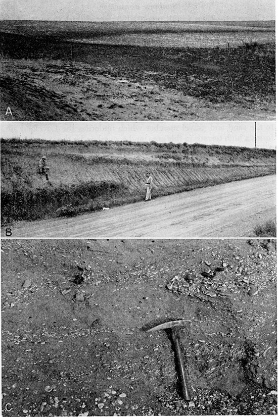
Character--Not only is the broad, low terrace along North Solomon Valley the most prominent physiographic feature in the mapped area (Pl. 4), but the deposits underlying this terrace surface constitute the most important aquifer in the area. The deposits underlying the Kirwin terrace surface represent essentially a single cycle of valley cutting and filling, although minor irregularities in the terrace surface suggest a complex of several partly developed alluvial cycles.
In general, the terrace surface throughout this area is underlain by 30 to 90 feet of unconsolidated deposits, which probably represent a single cycle of stream deposition. Test-hole data show that the Cretaceous bedrock beneath the terrace fill is immediately overlain by moderately sorted gravel, which grades upward into sand and gravel. This material is composed of Rocky Mountain type sand and gravel derived from the Ogallala formation in the headwaters of North Solomon River and intermixed with a small amount of material derived from local rocks of Cretaceous age. The coarser deposits grade upward into sandy silt and stratified silt in the upper part of the terrace fill. Good exposures of the upper 30 feet of the terrace deposits in cut banks along North Solomon River indicate that the silt beds are interstratified with thin lenticular beds of silty clay. The thickness of the finer-grained deposits is from 30 to 40 feet. One or more dark humic bands in the upper 6 feet of the terrace fill probably represent poorly developed soil zones that were buried by younger Hood-plain deposits in the closing stages of the terrace cycle.
The terrace deposits are probably of late Wisconsinan age, because they fill a well-developed valley that is incised considerably below the older Crete and Loveland stream deposits along the valley margins. The Peoria silt member of the Sanborn formation is apparently truncated along the valley walls, but its relation to the terrace deposits is not clear. No Peoria silt has been found overlying the terrace, but the upper silts in the terrace fill may correspond to the Bignell silt member of the uplands. The relation of the terrace to the channel of North Solomon River and its principal tributaries indicates the extreme youth of the terrace. The streams do not have fully developed meander belts but have meanders that are incised into the terrace surface. At many places along these streams, narrow peninsulas and islands of terrace deposits project into the meander loops (Pl. 1). These meanders, moving downstream, will eradicate the projections of terrace material and, in a short span of geologic time, will establish a meander belt of uniform width without the present incised character. Probably the present cycle of downcutting represents only a part of Recent time, and the terrace deposits are, in part, of Recent age.
Water supply--The terrace deposits are the most important water-bearing material in this area. The coarse-textured sand and gravel in the base of the terrace fill is quite permeable and lies below the water table. The broad, nearly Hat terrace surface constitutes a large recharge area and additional recharge is furnished by streams that head in the near-by hills of Cretaceous rocks and cross the terrace surface in shallow poorly developed channels. Where saturated deposits of the Crete sand and gravel member are found adjacent to the valley, they form a continuous hydrologic system with the lower-lying terrace deposits and water thus moves from the upland into the valley. Ground water moves laterally through the terrace deposits and into the alluvium or into the channel of North Solomon River. More than half the wells for which records are given in Table 15, including those supplying the cities of Logan, Speed, Kirwin, Smith Center, Gaylord, Portis, and Downs, obtain water from the terrace deposits. Well 5-14-1ca2 had the largest reported yield, 323 gallons per minute when test-pumped for 4 hours in 1940. Hydrologic data for the wells tested are given in Table 4. The chemical character of water from the terrace deposits is given in Tables 7, 8, and 11 and shown graphically in Figure 16.
Recent Alluvium
Character--The area mapped as alluvium (Pl. 1) consists of the Hood plain of North Solomon River and its principal tributaries. It is not possible, with the mapping scale used, to show the alluvium along the smallest streams. Along the North Solomon Valley the Hood plain is from one-tenth to one-half a mile wide and lies at an altitude of 15 to 25 feet below the level of the Kirwin terrace and 12 to 16 feet above the water level of the river. Segments of one or two poorly developed terrace levels in the Hood plain area suggest partly developed alluvial cycles, although the Recent alluvium probably represents only a single major cycle of cutting and filling. At many places in the North Solomon Valley the alluvium lies in a narrow valley that is cut through the terrace deposits into Cretaceous rocks. In other places the alluvium fills a channel that is cut into these deposits (Pl. 3).
Table 4--Hydrologic data for wells that have been test-pumped
| Well No. | Well owner | Date of pump test |
Depth to water, feet |
Discharge, gallons a minute |
Length of pump test, hours |
Drawdown, feet |
Specific capacity, gals. per min. per foot drawdown |
|---|---|---|---|---|---|---|---|
| 4-18-26da4 | R. I. R. R. no. 4 | 1943 | 21 | 275 | 24 | 23 | 11.96 |
| 4-18-26cc1 | Phillipsburg no. 1 | 1944 | 17 | 175 | 8 | 35 | 5.00 |
| 4-18-26cc2 | Phillipsburg no. 2 | 1944 | 17 | 200 | 8 | 38 | 7.90 |
| 4-18-26cc3 | Phillipsburg no. 3 | 1944 | 15 | 200 | 8 | 36 | 8.33 |
| 5-14-1ca1 | Gaylord (new well) | 1946 | 25 | 150 | 9 | 16.67 | |
| 5-14-1ca2 | Smith Center no. 3 | 1940 | 43 | 323 | 4 | 21 | 15.38 |
| 6-11-28a2 | Mo. Pac. R. R. | 1937 | 35 | 70 | 3 | 5 | 14.00 |
At several places in the Hood plain in Phillips County, the wind has piled up sand from the alluvium into dunes (Pls. 1, 4D). South of the river near Logan, on both sides of the river 3 miles east of Logan, and north of the river 6 miles west of Kirwin, thin layers of wind-drifted sand cover the terrace surface.
Only the upper part of the alluvium is exposed along the river channel, but its thickness and character are known from several test holes that penetrated these deposits. The alluvium consists largely of coarse sand and gravel intermixed with a small amount of silt and in places contains thin layers of clay. The coarse materials at the base of the alluvium grade upward into finer sands and silt near the Hood-plain surface. Along the river the alluvium ranges in thickness from 25 to 50 feet, but it may be considerably thinner in the small tributary streams a short distance from the river. The alluvium of these minor streams contains a large percentage of material derived from the Cretaceous rocks into which they are incised; it is generally poorly sorted, and may have a low permeability. Although they are poor aquifers, these deposits are the only waterbearing beds present in local areas.
The North Solomon Valley alluvium is the stream-deposited material that has accumulated since the close of the alluvial cycle during which the broad Kirwin terrace was formed. The alluvium is entirely of Recent age, and represents only a slight reworking of older material. More alluvium is added when Hoods rework alluvial material and deposit new material on the Hood plains.
Water supply--The water table in the Recent alluvium is continuous with the water table in the terrace deposits and with the water level in the Howing streams in the area. The alluvium lies largely below the water table;. and the coarse nature of the alluvial deposits makes them an important potential source of ground water. Along the North Solomon Valley, only a few wells tap these deposits, because the area where the alluvium is at the surface is subject to Hoods. A few stock wells and, near Glade, the Phillipsburg municipal wells and the Rock Island Railroad wells obtain water from these beds. In the upland adjoining the valley, where the Cretaceous rocks lie near the surface, the only available water supplies are in the alluvium of minor tributary valleys. In these areas even the alluvial wells frequently go dry during prolonged periods of drought. Chemical analyses of water from wells in the Recent alluvium are given in Tables 8 and 10, and are shown graphically in Figure 16.
Geologic History and Geomorphology
Pre-Pleistocene Geologic History
The oldest rocks exposed at the surface in the area covered by this report are shales of late Cretaceous age. The history of geologic events that preceded the deposition of these rocks is known partly from the records of deep tests for oil and partly from surface exposures of the deeply buried rocks east of this area. The oldest known rocks beneath this area are the Pre-Cambrian crystalline rocks that have been penetrated at depths of 3,800 to 4,000 feet in western Phillips County. A long period of erosion followed the formation of these rocks. The first rocks deposited after this erosion interval were marine sandstones, then a thick series of other marine rocks. At intervals the area was warped, raised above sea level, subjected to erosion, and later covered again by the sea. The youngest Paleozoic marine sediments beneath this area are the series of alternating shale and limestone of Permian age that is overlain by "redbeds." The redbeds record a late Permian interval of deposition in a great inland sea in which shale, siltstone, and evaporites accumulated.
After the formation of the redbeds, the area was again raised above sea level and subjected to a long period of subaerial erosion, which lasted throughout Triassic, Jurassic, and early Cretaceous time. Near the close of early Cretaceous time, the sea again covered the area, and marine sandstone and shale were deposited on the eroded surface of Permian rocks. At the beginning of late Cretaceous time, the sea withdrew somewhat and the sandstone and clay of the Dakota formation accumulated under near-shore conditions. The sea again covered the land, and the thick section of upper Cretaceous shale, chalk, and limestone that forms the bedrock in this area was deposited. At the close of Cretaceous time the sea withdrew from the plains region, and a continental environment has existed since that time.
During most of Tertiary time, western and central Kansas were subjected to subaerial erosion and great quantities of Cretaceous rocks were stripped off. The effect of this erosion was to bevel the Cretaceous rocks so that their upper surface slopes eastward. More than 1,000 feet of Cretaceous rocks still remain beneath western Phillips County, but only about 400 feet remain in western Mitchell County. By late Tertiary time, north-central Kansas was an area of low relief characterized by smooth gentle divides and broad valleys. During Pliocene time, the streams from the Rocky Mountains that crossed this area spread an apron of alluvial debris on the eroded surface of Cretaceous rocks. The irregularities of the bedrock surface were leveled, and as the streams shifted back and forth across the area, they built up an eastward-sloping alluvial plain, which may have extended from the Rocky Mountains nearly to the Flint Hills. As much as 300 feet of material (the Ogallala formation) was deposited in Norton County and westward, but these deposits thin rapidly eastward and only a few inches of Tertiary sediments cap the upland in Mitchell County. At the close of Tertiary time these sediments formed a nearly featureless eastward-sloping plain that was marked with small water-table lakes in which the fresh-water "Algal limestone" of the Ogallala formation was forming.
Pleistocene Geologic History and Geomorphology
The events that formed the present topographic features began with the close of "Algal limestone" deposition and the beginning of Pleistocene erosion. During early Pleistocene time, streams formed on the plain of the Ogallala formation and began to cut their way into and through this unconsolidated material. No deposits of Nebraskan age have been identified in this area, and the exact events that took place during that interval are unknown. The history of erosion during that time is inferred from the known record of the same interval elsewhere in Kansas. By Kansan time, major streams had been formed and the approximate pattern of modern drainage was established. These streams had intrenched their valleys to a level less than 100 feet above the greatest bedrock incision beneath the present valley. The deposits left by the Kansan streams are remnants of coarse channel deposits (Meade formation) that are found at several localities in this area. Figure 3, which shows generalized profiles of the Pleistocene deposits from localities in southern Norton County to Osborne County, suggests that the stream that deposited the Meade had a gradient across Phillips County equal to the gradient of the younger terrace deposits but that the gradient flattened somewhat in Osborne County. The relation of these beds to younger stream deposits is shown in Plate 3.
A period of pronounced erosion and downcutting followed the deposition of the stream deposits of the Meade formation. During this interval, the ancestral Solomon River intrenched its valley about 50 feet below the base of the Meade deposits. The stream deposits of late Illinoian (Crete) age fill a bedrock channel that has a gradient equal to that of the Meade across Smith County, but which is somewhat steeper upstream and somewhat reduced downstream. Deposits of the Crete sand and gravel member of the Sanborn formation overlie the gravel of the Meade in Norton County and may be channeled into the Meade in western Phillips County, although the older beds have not been identified there. Valley floors that were being aggraded during this interval probably were the source of the loess of the Loveland silt member of the Sanborn which was spread over a wide upland area by the wind. Late Sangamonian time was apparently a period of essential equilibrium when very little erosion took place and which was ideal for the formation of the well-developed soil of the Loveland.
During earliest Wisconsinan time, the older deposits were dissected by erosion and the main valley was lowered. Channel deposits overlying the bedrock have been penetrated by test drilling. In general, the terrace deposits seem to represent a single period of cut and fill, but test holes through these deposits near Clade and west of Downs have penetrated gravel immediately above the bedrock that seems to differ from the overlying gravel deposits. This gravel may represent deposits of early Wisconsinan age that are not present throughout the entire area. The only positively identified deposit of this age is the Peoria loess, which blankets the upland. This silt was picked up by the wind from the flood plains of the Platte and Republican Rivers and spread in a broad sheet across northwestern and north-central Kansas.
The interval following the deposition of the Peoria silt was marked by erosion of the uplands and by cutting of the principal bedrock valley, in which the younger terrace deposits accumulated. The bedrock surface was cut 30 to 60 feet below the deepest part of the Crete channel. Accumulation of the terrace fill beneath the Kirwin terrace surface was either contemporaneous with the cutting of the bedrock channel or soon after this period of erosion. The top of these deposits is a smooth, relatively undissected surface, which has a gradient across Phillips and western Smith Counties similar to the gradient on the Meade deposits (Fig. 3). The gradient is decreased somewhat near Cedar as if the resistant Fort Hays limestone member had lessened downcutting at that point, but downstream from Cedar the terrace has a steeper gradient than either the Meade or the Crete deposits.
The deposition of the terrace fill sediments beneath the Kirwin terrace surface probably took place in the last part of Wisconsinan time and in part of early Recent time. Evidence for the extreme youth of this terrace is presented in the stratigraphic discussion of the deposits. After this period of deposition, North Solomon River was again rejuvenated and incised its channel 30 feet or more into the terrace deposits. At some places (Pl. 3) the stream overlies a narrow channel cut into bedrock and filled with alluvial material, which is probably of Recent age. In other places the modern channel and flood plain overlie relatively high bedrock ridges which indicates that the stream has cut a channel into the terrace fill only during the latest cycle of downcutting. This cycle is clearly in an early stage of development, and the stream can be expected to broaden its flood plain, establish a meander belt, and probably cut a deeper bedrock channel before the cycle is completed.
Prev Page--Geography || Next Page--Ground water
Kansas Geological Survey, Geology
Placed on web May 24, 2014; originally published November 1952.
Comments to webadmin@kgs.ku.edu
The URL for this page is http://www.kgs.ku.edu/Publications/Bulletins/98/04_geol.html