![]()
Prev Page--Contents || Next Page--Geography
Introduction
Purpose and Scope of Investigation
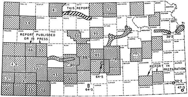
During the fall of 1945, the United States Geological Survey started a series of ground-water investigations as a part of the program of the Department of the Interior for development of the Missouri River basin. The investigations of ground-water resources in the Kansas part of the basin have been co-ordinated with the co-operative ground-water studies that were begun in 1937 by the U. S. Geological Survey, the State Geological Survey of Kansas, the Division of Sanitation of the Kansas State Board of Health, and the Division of Water Resources of the Kansas State Board of Agriculture. The present status of investigations resulting from these programs is shown in Figure 1.
Figure 1--Areas in Kansas where ground-water data are being collected and where co-operative ground-water studies have been or are being made.
As a part of the Missouri Basin program, a study of the geology and ground-water resources in the lower part of the valley of North Fork Solomon River was begun in the fall of 1945. During the first half of 1946, measurements of the water level in many wells in the area were made, test holes were drilled to determine the character and thickness of the water-bearing formations, a program of periodic observations of water-level fluctuations was started, and a geologic map of the area was prepared.
Construction of the proposed Kirwin Reservoir on North Fork Solomon River will provide storage capacity for 200,000 acre-feet of surface water, of which 80,000 acre-feet will be used for irrigation. The purposes of this investigation were: to study the natural ground-water conditions in the area before they were disturbed by the construction of the reservoir or by irrigation developments; to determine the availability and quality of ground water for domestic, stock, municipal, industrial, and irrigation supplies; to learn the geologic factors that are related to and that control the occurrence of ground water; to determine the chemical character of the water and its relation to geologic factors; and to study the relation of surface water in North Fork Solomon River to the ground water in the valley.
Present information on the mineralization of ground water in the North Solomon Valley will be used as reference data for future studies. Such studies should be made to determine the effect of irrigation on the mineralization of the ground water.
This investigation was made under the general supervision of A. N. Sayre, chief of the Ground Water Branch of the U. S. Geological Survey, and C. H. Taylor, regional engineer in charge of ground-water investigations in the Missouri River Basin.
The study of quality of water was under the general direction of S. K. Love, chief of the Quality of Water Branch, and under the supervision of P. C. Benedict, regional engineer in charge of quality-of-water investigations in the Missouri River Basin.
Location and Extent of the Area
The area described by this report is a narrow strip along the valley of North Fork Solomon River (referred to in this report as the North Solomon River); it extends from the western boundary of Phillips County, through southwestern Smith and northeastern Osborne Counties, to the confluence of North and South Forks of Solomon River near Cawker City in northwestern Mitchell County. Throughout this area the rocks bordering the valley consist of Cretaceous shales and chalks, which are relatively impervious and which differ in ground-water characteristics from the alluvial deposits of the valley. For this reason the valley is a distinct groundwater area. North and South Forks of Solomon River are part of the Kansas River system. They join in northwestern Mitchell County to form Solomon River, which flows east and southeast and which joins Smoky Hill River in northeastern Saline County.
The western half of this area, west of the Niobrara and Carlile contact near Cedar (Pl. 1), is in the area described by Adams (1903, p. 113) as the High Plains. The eastern part lies in the Smoky Hills Upland division (Adams, 1903) or in the Blue Hills Upland (Schoewe, 1949, fig. 22). Fenneman (1931, p. 25; Frye, 1946, p. 76) has suggested that alluviated and terraced valleys are not typical of the High Plains, and therefore, the references to physiographic districts serve only to place this area in its proper regional setting.
Previous Investigations
A recently published report on Norton and part of Phillips Counties (Frye and Leonard, 1949) describes the geology and ground water along the North Solomon River in Norton County. Field work has been completed and a report is being prepared on the geology and ground-water resources of Jewell County, which lies north of the eastern part of this area. Well inventories and observation-well programs have been started in the Glen Elder and Webster units of the Missouri Basin, which are adjacent to this area (Fig. 1).
Several early reports of the University Geological Survey of Kansas (Haworth, 1897; Logan, 1897; Williston, 1897) discussed the geology of this area. In 1913, Haworth briefly discussed the availability of ground water along the Solomon Valley. Landes (1930) described the geology of Mitchell and Osborne Counties and his report includes a brief discussion of the ground-water resources of the eastern part of this area. The general occurrence of ground water in Kansas and the significance of the Cretaceous rocks as aquifers were discussed by Moore and others (1940). Landes and Keroher (1942) described the mineral resources, including ground water, of Phillips County, and Lohman and others (1942) mentioned the general availability of ground water along the Solomon Valley. Reports on construction materials in Phillips County (Byrne, Beck, and Houston, 1948), in Smith County (Byrne, Houston, and Mudge, 1948) and in Mitchell County (Byrne, Johnson, and Bergman, 1951) have been prepared; a report for Osborne County is in preparation.
Methods of Investigation
During the winter and spring of 1946 I spent 4 1/2 months in the field completing the well inventory and mapping the geology. Many of the water-level measurements that were used in the preparation of the water-table contour map were made by John Sears and Milton Sears in the late fall of 1945. D. W. Berry made most of the water-level measurements since field work was completed. All measurements were made from a fixed measuring point at the top of each well with a steel tape graduated to hundredths of a foot. The altitude of the measuring point for each well was determined with an alidade and a plane table by C. K. Bayne assisted by Norbert Reibel. General information regarding the character and thickness of the water-bearing material, yields of wells, and use and quality of the water was obtained from many farmers in the area. Data on the municipal and industrial wells were obtained from the superintendents of municipal water plants and from the Layne-Western Co., Wilson & Co., the Chicago, Rock Island, & Pacific Railway Co., and the Missouri Pacific Railroad Co.
In April and May 1946, 57 test holes were drilled by J. B. Cooper and W. T. Connor, who used a portable hydraulic-rotary drilling rig owned and operated by the State Geological Survey. Samples of drill cuttings were collected and studied in the field by Cooper and were studied later in the office by me. Many test holes were drilled along the axis of the dam and in the vicinity of the dam site at Kirwin by the Bureau of Reclamation and Corps of Engineers. Cross section C-C' (Pl. 3) was based on logs of these test holes. Six other cross sections, which were prepared from test-hole data of the State Geological Survey, are also shown in Plate 3. These cross sections indicate the general character and thickness of the water-bearing materials in the valley and adjacent areas. Logs of all the test holes are included in this report.
Field mapping was done on county highway maps and was supplemented by use of aerial photographs of the U. S. Department of Agriculture. These photographs were used also to make highway corrections and to delineate the drainage shown on the geologic map (Pl. 1). Wells and test holes were located on the maps by measuring the distances from section corners and section lines with an odometer.
Samples of water from 18 stock and domestic wells in Mitchell, Osborne, Smith, and Phillips Counties were collected during March 1947 by D. W. Berry and samples from 4 stock and domestic wells in Smith County were collected in May 1950 by W. H. Durum and A. R. Leonard. Four samples of water for analysis were collected from North Solomon River at Kirwin to determine the relation of the mineral content of the ground water to that of the low-flow surface water. Samples of water were collected from each municipal supply by the Kansas State Board of Health and were analyzed by Howard Stoltenberg in the laboratory of the Board of Health in Lawrence, Kansas. The samples of water collected from the stock and domestic wells and from the river were analyzed by W. M. Barr and J. Bonebright in the laboratory of the Federal Geological Survey at Lincoln, Nebraska.
Well-Numbering System
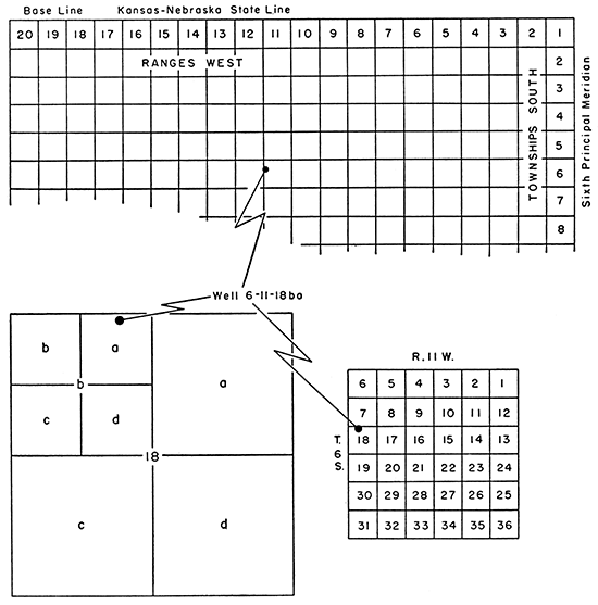
The Federal Geological Survey has adopted a system for numbering wells and test holes in the Missouri Basin which utilizes the General Land Office survey according to the following sequence: township, range, section, quarter section, and 40-acre tract within that quarter section. The numbers used to designate the township, range, and section are those assigned in the General Land Office survey. The quarter-section and 40-acre tracts are lettered a, b, c, or d in a counter-clockwise direction beginning in the northeast quadrant. For example, well 6-11-18ba is located in the NE NW sec. 18, T. 6 S., R. 11 W. (Fig. 2). If two or more wells are located within a 40-acre tract, they are numbered serially according to the order in which they were inventoried.
Figure 2--Diagram illustrating the well-numbering system used in this report.
Acknowledgments
Appreciation is expressed to the many persons who co-operated and assisted in the collection of field data. Special thanks are extended to the water superintendents and other officials of the Cities of Logan, Speed, Phillipsburg, Kirwin, Gaylord, Smith Center, Portis, and Downs for information concerning their municipal wells, the use of water, and other pertinent data; to the officials of the Chicago, Rock Island, & Pacific Railway Co. for data on their wells near Glade; to D. R. Soder and the other officials of Layne-Western Co. for test-hole and well data on the Phillipsburg and Smith Center wells; and to C. F. Popejoy and other officials of the Missouri Pacific Railroad Co. for data on their wells in this area.
J. C. Frye spent several days in the field with me and gave valuable assistance in interpreting the terrace and loess stratigraphy. Ada Swineford assisted in measuring and identifying outcrops of the Ogallala. W. W. Wilson drafted the maps and other illustrations.
The manuscript of this report has been reviewed critically by several members of the Federal and State Geological Surveys; by Robert Smrha, chief engineer, and George S. Knapp, engineer, Division of Water Resources of the Kansas State Board of Agriculture; and by Dwight Metzler, chief engineer, and Willard Hilton, geologist, Division of Sanitation of the Kansas State Board of Health.
Prev Page--Contents || Next Page--Geography
Kansas Geological Survey, Geology
Placed on web May 24, 2014; originally published November 1952.
Comments to webadmin@kgs.ku.edu
The URL for this page is http://www.kgs.ku.edu/Publications/Bulletins/98/02_intro.html