Kansas Geological Survey, Bulletin 90, part 2, originally published in 1951
Originally published in 1951 as Kansas Geological Survey Bulletin 90, part 2. This is, in general, the original text as published. The information has not been updated.
The discovery of the Davis Ranch oil pool in Wabaunsee County, Kansas, in April 1949 started one of the most important leasing and wildcat drilling programs in Kansas in recent years. In the 21 months since the completion of the discovery well, 65 holes have been drilled in Wabaunsee County alone. Of this total 38 may be classed as wildcat or semiwildcat wells, three of which have opened additional new pools.
In view of the increased activity in Wabaunsee County and the Kansas part of the Forest City basin, a report showing our interpretations of the stratigraphy and structural relations of the Davis Ranch pool has been considered appropriate. All interpretations must be considered tentative until further information is received by the Survey.
On February 1, 1951, the Davis Ranch pool had 18 producing oil wells. Six dry holes have been drilled and one oil well, the Aladdin and Bakke No. 1 Schutter in the SW SW SW sec. 34, T. 13 S., R. 10 E. was abandoned in December 1950. This well was the only producing well in the Davis Ranch East pool.
The structure shown by the surface rocks is a north-northeast trending anticline with a closure of more than 20 feet. The Davis Ranch anticline is located on the northeast-trending subsurface Alma anticline which extends northward into Pottawatomie County and southward into Lyon County. The pre-Pennsylvanian structure is marked by a reverse fault which is not noticeable in the surface structure.
Seventeen wells produce from the Viola dolomite and one well from the "Hunton" dolomite in the Davis Ranch pool. The thickness of the oil-saturated porous zone in the Viola ranges from a featheredge to 20 feet. Initial productivity tests indicated little or no water present in the producing zone.
Plate 1--Stratigraphic sequence in Davis Ranch pool, Wabaunsee Co. (PDF file, 2.1 MB)
Plate 2--Diagrammatic cross section, Davis Ranch and Davis Ranch East pools (PDF file, 1.9 MB)
The investigation that yielded this report was inaugurated by the important discovery of oil in the Davis Ranch pool and was undertaken as a result of an increased demand for information concerning structural and stratigraphic aspects of the southwestern part of the Forest City basin, especially in Wabaunsee County, Kansas.
Before the discovery of the Davis Ranch pool the importance of the Forest City basin as a potential producer of oil had been overlooked by petroleum geologists. Oil had been found in the "Hunton" dolomite in Nemaha and Brown Counties, Kansas, and in southeastern Nebraska. Also Pennsylvanian sands and upper Mississippian rocks have produced oil in the southwestern part of the basin, but the production of all these pools has been small.
The Davis Ranch pool was discovered in April 1949 by the Carter Oil Company when the No. 1 G. H. Davis "A" well was drilled in the SW SE SW sec. 33, T. 13 S., R. 10 E. As this report is prepared the pool has been extended to include 680 productive acres in parts of secs. 28 and 33, T. 13 S., R. 10 E., and sec. 4, T. 14 S., R. 10 E. The pool was named for the ranch on which the discovery well was drilled.
The pool is 10 miles south of Alma, Kansas, the county seat of Wabaunsee County, and approximately 35 miles west-southwest of Topeka. It is situated in the Flint Hills Upland which is characterized topographically by a series of east-facing limestone escarpments considerably dissected by streams which have deep precipitous channels lined with rock ledges. The vegetation is dominantly "blue stem" grass which affords the excellent grazing facilities for which the region is so well known.
The pool lies 9 miles east of the Nemaha anticline and in the southwestern part of the Forest City basin which, because of its synclinal nature, had been shunned by oil geologists. With the completion of the discovery well extensive exploration and drilling programs were started by several oil companies with efforts being concentrated largely in Wabaunsee County. Prior to the discovery of the pool only 31 wells had been drilled in the county in search for oil and gas and only 18 of these extended to depths below Pennsylvanian strata. Since the discovery, 65 wells have been drilled or are being drilled to February 1, 1951. Data on these wells are given in Table 1. The locations of wells listed in Table 1 are shown on Figure 1.
Figure 1--Map of Wabaunsee County showing locations of wells drilled or drilling February 1, 1951. Numbers correspond to numbers in Table 1.
Table 1--Data on wells drilled in Wabaunsee County.
| No. on map |
Company and farm |
Location | Date completed |
Total depth, feet |
Initial production |
Depth below sea level to top of lowest formation penetrated, feet |
|---|---|---|---|---|---|---|
| 1 | Parker Oil Co. No. 2 Bardwell |
NW cor. 26-10-9E |
1915? | 1,093 | D&A | Pre-Cambrian +56 |
| 2 | Jennings Oil Co. No. 1 Miller |
NW SE NE 12-10-10E |
7-1-18 | 2,215 | D&A | Lower Pennsylvanian ? |
| 3 | Ben F. Brack No. 1 Uhlrig |
NE NE NE 13-10-10E |
12-31-50 | 3,206 | D&A | Arbuckle -2,122 |
| 4 | Amerada Petro. Corp. No. 1 L. E. Morton |
SW SW NW 28-10-10E |
11-22-48 | 1,918 | D&A | Maquoketa -863 |
| 5 | Amerada Petro. Corp. No. 1 W. W. Bolton |
SW SW SE 32-10-10E |
8-24-48 | 1,720 | D&A | Pre-Cambrian -642 |
| 6 | Amerada Petro. Corp. No. 1 Adelaide Enlow |
SW SW SE 33-10-10E |
10-8-48 | 2,705 | D&A | Pre-Cambrian -1,623 |
| 7 | Amerada Petro. Corp. No. 1 Marie Stewart |
SE SW NW 34-10-10E |
12-12-48 | 2,371 | D&A | Mississippian -1,111 |
| 8 | Adkins & Appelman No. 1 McLaughlin |
SE SE SE 26-10-11E |
4-14-50 | 3,243 | D&A | Arbuckle -2,080 |
| 9 | B & R Drilling, Inc. No. 1 McKema |
SW SW NE 30-10-12E |
10-21-49 | 3,200 | D&A | Arbuckle -2,161 |
| 10 | Empire Oil & Gas Co. No. 1 Root Cen. |
SW NE 1-11-9E |
? | 1,895 | D&A | Pre-Cambrian -28 |
| 11 | S. W. Forrester et al. No. 1 Frank Jones |
NE cor. SW 24-11-9E |
10-16-28 | 1,597 | D&A | Pre-Cambrian -213 |
| 12 | Amerada Petro. Corp. No. 1 Elizabeth Enlow |
SE SE SE 4-11-10E |
11-6-48 | 2,575 | D&A | Kinderhookian -1,275 |
| 13 | Amerada Petro. Corp. No. 1 Allie Willig |
SE SE SE 5-11-10E |
9-17-48 | 2.,489 | D&A | Pre-Cambrian -1,396 |
| 14 | Amerada Petro. Corp. No. 2 Allie Willig |
NW NW SW 5-11-10E |
10-21-48 | 1,523 | D&A | Pre-Cambrian -389 |
| 15 | Amerada Petro. Corp. No. 1 Sherman Mertz |
SW SW NE 6-11-10E |
8-10-48 | 1,234 | D&A | Pre-Cambrian -144 |
| 16 | Carter Oil Co. No. 1 Hankammer |
SW SW SE 27-11-10E |
10-7-49 | 3,365 | D&A | Arbuckle -2,137 |
| 17 | Ramsey Petro. Co. No. 1 Kaul |
SE NE NE 2-11-11E |
3-2-26 | 2,830 | D&A | "Hunton" -1,475 |
| 18 | Kansas Oil Assoc. No. 1 Louis Willie |
SW NW NW 5-11-11E |
8-5-18 | 2,700 | D&A | Chattanooga -1,266 |
| 19 | Skelly Oil Co. No. 1 Fearon |
NW SW NE 11-11-11E |
10-6-50 | 2,904 | 254 BOPD | Viola -1,773 |
| 20 | Skelly Oil Co. No. 1 Reiners |
NE SE NW 11-11-11E |
12-29-50 | 3,130 | SWDW | Arbuckle -1,993 |
| 21 | Skelly Oil Co. No. 2 Fearon |
SE NW NE 11-11-11E |
Drlg. | |||
| 22 | ? No. 1 Newbury |
Cen. NW NE 22-11-11E |
? | 500 | D&A | Douglas ? |
| 23 | M. C. Bullock No. 1 McFarland |
SW cor. 31-11-11E |
10-?-1892 | 2,006 | D&A | Cherokee ? |
| 24 | Helmerich & Payne No. 1 Uhlig |
SE SE SW 8-11-12E |
10-7-49 | 3,227 | D&A | Arbuckle -2,104 |
| 25 | R. E. Adams & Murfin No. 1 Adams |
N2 SW NE 14-11-12E |
6-23-50 | 3,094 | D&A | Simpson -1,959 |
| 26 | Sunflower Drilling Co. No. 1 Reichman |
SW SW NE 26-12-9E |
3-3-50 | 3,135 | D&A | Viola -1,927 |
| 27 | Carter Oil Co. No. 1 Meseke |
SE SE NE 29-12-9E |
12-2-49 | 2,421 | D&A | Arbuckle -1,028 |
| 28 | Coleman-Edgerton No. 1-B Smith |
NW SE SE 9-12-10E |
3-22-29 | 276 | 44,000 cu.ft. gas |
? ? |
| 29 | American Petro. Co. No. 1 Schmidt |
Cen,. SE SE 9-12-10E |
11-2-27 | 2,339 | D&A | Mississippian -1,141 |
| 30 | Ray Anderson No. 1 Morris |
NE SW SW 36-12-10E |
11-3-50 | 3,063 | D&A | Viola -1,952 |
| 31 | Thrifty Drilling Co. No. 1 Strowig |
SE SW SW 3-12-11E |
9-30-49 | 3,383 | D&A | Arbuckle -2,106 |
| 32 | E. F. Wakefield No. 1 Schwalm |
NW NW NE 5-12-11E |
5-26-50 | 3,184 | D&A | Arbuckle -2,111 |
| 33 | Cosden Oil & Gas Co. No. 1 Renker |
SW SE 17-12-11E |
11-21-16 | 1,880 | D&A | Cherokee ? |
| 34 | Skelly Oil Co. No. 1 Wolgast |
SE NE SW 18-12-11E |
Drlg. | |||
| 35 | Empire Oil & Gas Co. No. 1 Schwalm |
SE cor. 19-12-11E |
1-25-28 | 3,431 | D&A | Simpson -2,037 |
| 36 | Forrester-Cook No. 1 Schultz |
NW SE SE 2-13-8E |
? | 2,385 | D&A | ? ? |
| 37 | Skelly Oil Co. No. 1 Thowe |
SE NW SE 2-13-10E |
8-25-50 | 3,162 | D&A | Arbuckle -2,040 |
| 38 | Skelly Oil Co. No. 2 Thowe |
SW SE NE 2-13-10E |
9-29-50 | 2,932 | 3,000 BOPD | Viola -1,818 |
| 39 | Skelly Oil Co. No. 3 Thowe |
NW NE SE 2-13-10E |
1-26-51 | 2,921 | 121 BOPD | Viola -1,818 |
| 40 | Skelly Oil Co. No. 4 Thowe |
SW NE SE 2-13-10E |
Drlg. | |||
| 41 | Skelly Oil Co. No. 1 Powell |
SW NE NE 2-13-10E |
12-8-50 | 2,941 | 33 BOPD | Viola -1,834 |
| 42 | Jones, Shelburne & Farmer, No. 1 Joss |
SE SW SW 4-13-10E |
6-23-50 | 3,430 | D&A | Viola -1,952 |
| 43 | Sunflower Oil Co. No. 1 McComb |
SE SW NW 6-13-10E |
5-26-50 | 3,307 | D&A | Arbuckle -2,093 |
| 44 | Manhattan Oil Co. No. 1 Steinmeyer |
NE cor. W2 SW 11-13-10E |
5-28-27 | 2,405 | D&A | Mississippian -1,106 |
| 45 | Skelly Oil Co. No. 1 Stuewe |
NW NW SW 11-13-10E |
10-28-49 | 3,320 | D&A | Arbuckle -2,069 |
| 46 | C. L. Carlock No. 1 Waugh |
SE SE SW 13-13-10E |
1-4-50 | 3,405 | D&A | Viola -1,937 |
| 47 | W. E. Bakke & Aladdin No. 1 Schutter |
NE NW NE 22-13-10E |
10-7-49 | 3,360 | D&A | Arbuckle -2,038 |
| 48 | El Capitan No. 1 Buckli |
SE SE NW 25-13-10E |
2-17-50 | 3,518 | D&A | Arbuckle -2,060 |
| 49 | Plains Exploration & Sterling No. 1 Schwanke |
SW SW SE 27-13-10E |
9-23-49 | 3,290 | D&A | Viola -1,926 |
| 50 | Carter Oil Co. No. 1 Davis "C" |
SW SE SW 28-13-10E |
2-22-50 | 3,192 | 2,970 BOPD | Viola -1,782 |
| 51 | Carter Oil Co. No. 2 Davis "C" |
SW SW SE 28-13-10E |
6-9-50 | 3,181 | 2,735 BOPD | Viola -1,749 |
| 52 | Carter Oil Co. No. 3 Davis "C" |
SW NW SE 28-13-10E |
7-28-50 | 3,139 | 83 BOPD | Viola -1,789 |
| 53 | Carter Oil Co. No. 4 Davis "C" |
SW SE SE 28-13-10E |
9-29-50 | 3,308 | D&A | Viola -1,944 |
| 54 | Westgate-Greenland No. 1 Kirkham |
NE NE SW 32-13-10E |
10-10-49 | 3,382 | D&A | Simpson -1,940 |
| 55 | Carter Oil Co. No. 1 Davis "A" |
SW SE SW 33-13-10E |
6-1-49 | 3,206 | 2,580 BOPD | Viola -1,789 |
| 56 | Carter Oil Co. No. 2 Davis "A" |
SW NE SW 33-13-10E |
7-28-49 | 3,425 | 2,936 BOPD | Arbuckle -1,962 |
| 57 | Carter Oil Co. No. 3 Davis "A" |
SW SW SE 33-13-10E |
9-21-49 | 3,190 | 3,000 BOPD | Viola -1,759 |
| 58 | Carter Oil Co. No. 4 Davis "A" |
SW SE NW 33-13-10E |
9-28-49 | 3,208 | 3,000 BOPD | Viola -1,764 |
| 59 | Carter Oil Co. No. 5 Davis "A" |
SW NE NW 33-13-10E |
1-13-50 | 3,20,3 | 3,000 BOPD | Viola -1,752 |
| 60 | Carter Oil Co. No. 6 Davis "A" |
SW NW SE 33-13-10E |
4-14-50 | 3,192 | 2,990 BOPD | Viola -1,753 |
| 61 | Carter Oil Co. No. 7 Davis "A" |
SW SE SE 33-13-10E |
12-19-49 | 3,341 | D&A | Viola -1,929 |
| 62 | Carter Oil Co. No. 8 Davis "A" |
SW NW NW 33-13-10E |
1-6-50 | 3,221 | 3,000 BOPD | Viola -1,784 |
| 63 | Carter Oil Co. No. 9 Davis "A" |
SW SW NW 33-13-10E |
2-1-50 | 3,255 | 1,574 BOPD | Viola -1,797 |
| 64 | Carter Oil Co. No. 10 Davis "A" |
SW SW NE 33-13-10E |
5-5-50 | 3,162 | 3,000 BOPD | Viola -1,750 |
| 65 | Carter Oil Co. No. 11 Davis "A" |
SW NW NE 33-13-10E |
5-26-50 | 3,182 | 3,000 BOPD | Viola -1,737 |
| 63 | Carter Oil Co. No. 12 Davis "A" |
SW NW NE 33-13-10E |
1-19-51 | 2,938 | 44 EOPD | "Hunton" -1,505 |
| 67 | Aladdin & Bakke No. 1 Schutter |
SW SW SW 34-13-10E |
12-10-49 | 3,314 | 25 BOPD | Viola -1,907 |
| 68 | Alf M. Landon et. al. No. 1 Waugh |
SW SW NW 11-13-12E |
9-16-49 | 3,142 | D&A | Arbuckle -1,904 |
| 69 | Williams et al. No. 1 Henderson |
SW NE 15-13-12E |
? | 3,652 | D&A | Pre-Cambrian ? |
| 70 | C. W. Chapman No. 1 Schwarting |
SW SW NW 19-13-12E |
12-9-49 | 3,410 | D&A | Arbuckle -1,998 |
| 71 | Waugh Brothers No. 1 Martin |
SE SE NE 34-13-12E |
12-2-49 | 3,270 | D&A | Arbuckle -1,901 |
| 72 | Pinnacle Oil & Gas Co. No. 1 E. Martin |
NE 35-13-12E |
7-11-19 | 3,640? | D&A | ? ? |
| 73 | John Zinn No. 1 Langvardt |
NE SW SE 1-14-8E |
6-2-37 | 625 | D&A | Lower Permian ? |
| 74 | C. B. Rose No. 1 Harteraft |
Cen. NE 2-14-8E |
10-10-34 | 618 | D&A | Lower Permian ? |
| 75 | C. B. Rose No. 2 W. W. Stice |
SW cor. 2-14-8E |
11-10-33 | 700 | D&A | Lower Permian ? |
| 76 | C. B. Rose No. 1 W. W. Stice |
Cen. SW NW 11-14-8E |
4-14-32 | 604 | D&A | Lower Permian ? |
| 77 | Carter Oil Co. No. 1 Davis "B" |
SW NE NW 4-14-10E |
8-16-49 | 3,221 | 3,000 BOPD | Viola -1,782 |
| 78 | Carter Oil Co. No. 2 Davis "B" |
SW SE NW 4-14-10E |
11-9-49 | 3,205 | 3,000 BOPD | Viola -1,790 |
| 79 | Carter Oil Co. No. 3 Davis "B" |
SW NW NE 4-14-10E |
11-25-49 | 3,183 | 3,000 BOPD | Viola -1,767 |
| 80 | Carter Oil Co. No. 4 Davis "B" |
SW SW NE 4-14-10E |
12-23-49 | 3,191 | 3,000 BOPD | Viola -1,777 |
| 81 | Carter Oil Co. No. 5 Davis "B" |
SW NE NE 4-14-10E |
1-4-50 | 3,306 | SWDW | Viola -1,928 |
| 82 | E. F. Wakefield et al. No. 1 Miller |
SE SW NW 3-14-10E |
10-13-50 | 3,250 | D&A | Viola -1,921 |
| 83 | L. S. Abercrombie No. 1 Lockhart |
NW SW NW 12-14-10E |
6-2-50 | 3,515 | D&A | Arbuckle -2,059 |
| 84 | Carter Oil Co. No. 1 Wingate "A" |
SE SE SE 17-14-10E |
11-3-50 | 3,398 | D&A | Viola -1,867 |
| 85 | Sterling Drilling Co. No. 1 Hoch |
NW NW SE 19-14-10E |
6-24-49 | 3,522 | D&A | Arbuckle -2,020 |
| 86 | Carter Oil Co. No. 1 Olsen |
SW NW SE 20-14-10E |
1-20-50 | 3,490 | D&A | Arbuckle -1,963 |
| 87 | Davis & Childs et al. No. 1 Hock |
SW SW SW 21-14-10E |
4-24-50 | 3,472 | D&A | Arbuckle -1,956 |
| 88 | B & R Drilling, Inc. No. 1 Schultz |
SE SE NW 22-14-10E |
9-23-49 | 3,614 | D&A | Arbuckle -2,078 |
| 89 | FA Capitan No. 1 Converse |
SW SW NE 23-14-10E |
12-23-49 | 3,409 | D&A | Viola -1,866 |
| 90 | El Capitan No. 1 Converse |
NW NW NW 35-14-10E |
5-12-50 | 3,401 | D&A | Simpson -1,961 |
| 91 | Benedum & Trees No. 1 Lockhart |
SW cor. 17-14-11E |
? | 2,665 | D&A | Cherokee -669 |
| 92 | Phillips & Ajax No. 1 Glick |
NE NE SW 16-14-12E |
3-3-50 | 3,223 | D&A | Arbuckle -1,847 |
| 93 | Holborne Oil Co. No. 1 Stevenson |
SW cor. NE 29-14-12E |
5-15-26 | 2,510 | D&A | Mississippian -1,031 |
| 94 | Carter Oil Co. No. 1 Mary Dorgan |
SW SW NE 6-15-10E |
10-27-49 | 3,446 | D&A | Arbuckle -1,980 |
| 95 | Carter Oil Co. No. 1 Woodbury |
SE SW NE 11-15-10E |
11-20-50 | 3,293 | D&A | Simpson -1,872 |
| 96 | Carter Oil Co. No. 2 Woodbury |
SE NW NE 11-15-10E |
1-26-51 | 3,335 | 108 BOPD | St. Peter -1,873 |
| 97 | ? No. 1 Wilson |
NE SW NE 5-15-11E ? |
1,052 | D&A | Upper Pennsylvanian ? |
It is not the purpose of this report to forecast future possibilities for oil in the region or to recommend possible new locations for wells. We will review the drilling activity to date and present our interpretations of the subsurface relationships and the engineering aspects of the pool. It must be understood that the maps and sections for this report were drawn and interpreted using the data available in the files of the State Geological Survey of Kansas and geologic engineering information which the Carter Oil Company has generously released for use in this report. All interpretations must be considered tentative until further information is received by the Survey.
Acknowledgments--Special thanks are extended to the numerous staff members of the Carter Oil Company who have released engineering data on individual wells in the Davis Ranch pool. C. W. Couser, geologist, W. C. Schuldt, district geologist in Kansas, and Lee C. Lamar, geologist, all employed by the Carter Oil Company, have reviewed this report. However, the geologic interpretations are our own, and do not necessarily agree with those of the Carter Oil Company.
The geological surface mapping which led to the development of the Davis Ranch pool was done by a Carter Oil Company field party supervised by C. W. Couser. Oil was discovered in the Viola formation at a depth of 3,199 feet in the No. 1 Davis "A" well in the SW SE SW sec. 33, T. 13 S., R. 10 E. which was completed in May 1949. The well was assigned an initial daily production of 2,580 barrels of oil in a drawdown potential test. A show of oil was evident from 1,846 to 1,856 feet in the Swope limestone near the base of the Kansas City group of Pennsylvanian age. A drill-stem test taken from 1,843 to 1,859 feet, with the tool open for 1 1/2 hours, recovered 20 feet of oil and 70 feet of oil-cut mud.
Drilling operations on the No. 1 Davis "A" well proceeded to the top of the Viola, where a show of oil was apparent from 3,199 to 3,201 feet. A core taken from 3,202 to 3,206 feet recovered 2 feet and 3 inches of saturated dolomite with good porosity. A drill-stem test from 3,201 to 3,206 feet, with tool open for 1 1/2 hours, recovered 1,900 feet of clean 29° gravity oil. Seven-inch casing was set to 3,201 feet and a swabbing test produced 52 1/2 barrels of oil in 6 hours. Pumping tests produced 500 barrels of oil in 50 hours, 129 barrels of oil in 12 hours, and 145 barrels of oil in 8 hours.
The second well drilled, the No. 2 Davis "A" well in the SW NE SW sec. 33, T. 13 S., R. 10 E., penetrated the Arbuckle dolomite for 35 feet in search of a second producing zone. Eight drill-stem tests, taken at various horizons between the base of the producing zone in the Viola and the bottom of the hole, were unsatisfactory, however, and the hole was plugged back to 3,252 feet; the well was given an initial production of 2,936 barrels of oil per day with no water in a drawdown test.
The fourth well drilled, the No. 3 Davis "A" well in the SW SW SE sec. 33, T. 13 S., R. 10 E., had a slight show of oil in the "Hunton" dolomite from 2,944 to 2,948 feet. A drill-stem test taken from 2,947 to 2,950 feet recovered only 1,185 feet of salt water, however. A drawdown test revealed an initial production for this well of 3,000 barrels of oil per day from the Viola.
The next five wells, all drilled by the Carter Oil Company in extending the pool, had maximum initial daily productions of 3,000 barrels of oil per day. The average absolute completion potential for the first seven wells (Nos. 1-4 Davis "A" and Nos. 1-3 Davis "B") was 6,810 barrels of oil per day.
On December 10, 1949, the Aladdin and Bakke No. 1 Schutter well in the SW SW SW sec. 34, T. 13 S., R. 13 E. was completed with a physical potential of only 25 barrels of oil per day from the Viola, the fluid being 91 percent water. The gravity of the oil is 21° as compared to an average of 29° gravity oil in the Davis Ranch wells. Because of two dry holes completed later between the Schutter well and the producing Davis Ranch wells this well opened the Davis Ranch East pool. The Schutter well was abandoned in December 1950 and no further drilling has been done in the pool to date.
The two dry holes between the Davis Ranch and Davis Ranch East pools were drilled by the Carter Oil Company. They are the No. 7 Davis "A" well in the SW SE SE sec. 33, T. 13 S., R. 10 E., and the No. 5 Davis "B" well in the SW NE NE sec. 4, T. 14 S., R. 10 E. The No. 5 Davis "B" well had a slight show of oil in the Viola.
At the time this report was prepared 21 holes, 18 of them producers, had been completed in the Davis Ranch pool. All production is from the Viola dolomite with the exception of the No. 12 Davis "A" well in the SW NW NE sec. 33, T. 13 S., R. 10 E. which produces from the "Hunton" dolomite.
The sequence of rocks in the immediate area of the Davis Ranch pool is shown in detail in the columnar section on Plate 1. A detailed description of rocks encountered in the subsurface of northeastern Kansas has been presented in Lee's (1943) report on the Forest City basin of Kansas. A description of outcropping rocks and further information on subsurface rocks of northeastern Kansas may be found in a more recent report by Moore and others (1950) entitled "The Kansas Rock Column." Much detailed work done on the Pennsylvanian rocks of northeastern Kansas by Moore, Jewett, and others is reported in numerous publications by the Kansas Geological Survey. A detailed description of the regional stratigraphy will not be included in this paper. Only those characteristics deviating from the general rule will be discussed.
The rocks of Ordovician age encountered in the Davis Ranch pool are the middle part of the Arbuckle dolomite; the St. Peter sandstone of Simpson age; the Platteville formation; the Kimmswick dolomite of Viola age; and the Maquoketa shale. An average thickness for the entire sequence, excluding the Arbuckle dolomite, is approximately 265 feet.
Arbuckle dolomite is the common designation by petroleum geologists for Lower Ordovician and Upper Cambrian rocks in eastern Kansas. The term applies to the sequence between the St. Peter sandstone and the Bonneterre dolomite. The Carter Oil Company No. 2 Davis "A" well in the SW NE SW sec. 33, T. 13 S., R. 10 E. penetrated 35 feet of middle Arbuckle dolomite. At this location the middle part of the Arbuckle consists of dark-blue to brown crystalline dolomite, with a slight amount of opaque chert in the upper 15 feet.
The Simpson group has a thickness of 65 feet in this area. The lower 25 feet, representing the St. Peter, consists of characteristic unusually pure white well-rounded and frosted sand. The upper 40 feet is predominantly sandy shale.
The Platteville formation attains a thickness of 32 feet in the Carter Oil Company No. 2 Davis "A" well. The lower 28 feet consists of dark-brown crystalline dolomite with thin layers of limestone in the lower 15 feet. Rounded and frosted sand grains are disseminated throughout the dolomite but were not apparent except in the insoluble residues. The lower 10 feet has less than 5 percent gray opaque chert. The upper 4 feet of the Platteville is a dark and gray-green dolomitic shale.
The Kimmswick dolomite, commonly called the Viola dolomite in eastern Kansas, is 85 feet thick in the No. 2 Davis "A" well and may be divided into three zones in this area. The lower 25 feet is dark-brown to dark-blue sucrosic to crystalline dolomite with only a trace of opaque chert. The middle zone consists of 35 feet of brown sucrosic dolomite with 5 percent dark-gray opaque chert. There are a few thin layers of buff lithographic limestone in the lower 15 feet of this zone. The upper 25 feet is buff crystalline very porous dolomite which is free of chert. Well-formed dolomite rhombohedrons occur on the walls of the numerous cavities. The upper zone is the producing zone of the Davis Ranch pool.
The Maquoketa shale maintains a remarkably constant thickness of 80 feet in this area except in the Carter Oil Company No. 4 Davis "C" well where an abnormal thickness of 146 feet is present (Pl. 2). This abnormal thickness for the Maquoketa is probably due to repetition as a result of reverse faulting. The Maquoketa is roughly separated into an upper and lower part. The lower part is quite argillaceous and consists of slightly silty dark shale. The upper zone is an impure silty dolomite with traces of semiopaque gray chert and varying amounts of glauconite. In some of the samples, red shale was observed in the upper part of this zone.
Many unconformities occur in the Ordovician throughout this area, the most important of which occurs at the base of the St. Peter sandstone where the Arbuckle was eroded before the deposition of the St. Peter. The Simpson group is overlain unconformably by the Platteville formation. The Maquoketa shale lies unconformably on the Kimmswick dolomite and the Maquoketa is obscurely unconformable below Silurian rocks (Lee, 1943, pp. 25-42).
The term "Hunton" is used by petroleum geologists to designate undifferentiated limestones and dolomites of Silurian and Devonian age in northeastern Kansas. It includes the sequence of rocks between the Maquoketa and Chattanooga shales. The thickness of Silurian rocks in the area of the Davis Ranch pool averages 100 feet, but it increases rapidly to the north and decreases rapidly to the south.
The basal part of the Silurian consists of buff-colored sucrosic dolomite characterized by the presence of dolomitized oölites. This zone is approximately 30 feet thick. The upper 70 feet of Silurian rocks consists of light-gray sucrosic porous dolomite. The many voids are lined with small dolomite rhombohedrons. The upper 10 feet of this zone contains a very slight amount of light-gray opaque chert in some of the wells. The chert may, however, be from cavings of the Devonian dolomite above. This porous zone is remarkably persistent throughout the area.
The Silurian is overlain unconformably by the undifferentiated dolomites of the Devonian. The unconformity at the top of the Silurian is the cause of the great variation in thicknesses of the "Hunton" from north to south where pre-Devonian erosion has beveled the Silurian in decreasing thicknesses to the south (Lee, 1943, p. 45).
No attempt has been made to subdivide the Devonian rocks in this area. Their thickness ranges from 25 to 30 feet in the immediate area of the pool. As in the case of the Silurian the thickness increases northward and decreases southward. In the Aladdin and Bakke No. 1 Schutter well in sec. 22, T. 13 S., R. 10 E., which is 2 miles north of the pool, the thickness has increased to 40 feet.
The lower 10 to 15 feet of the Devonian consists of sucrosic arenaceous dolomite with rounded and frosted grains of sand disseminated throughout. In many wells the sand grains are not apparent except in the insoluble residues while in others the grains can be seen imbedded on the fractured faces of the dolomite. The amount of sand ranges from a trace to about 20 percent of the sample. The base of the sandy zone is the base of the, Devonian dolomite. In some of the wells of the pool the samples consist of 30 to 40 percent light-gray to white opaque chert. In other wells the amount of chert is less than 5 percent.
The upper 15 to 20 feet of Devonian rocks is composed of buff to brown sucrosic fine-grained dolomite with only a slight trace of light-gray chert. In a few of the wells, where the upper 5 to 10 feet is slightly more porous than in other wells, there is an indication of oil staining.
The Devonian rocks are underlain unconformably by the Silurian dolomite and are overlain unconformably by the Chattanooga shale. The unconformities represented here are two of the most important in northeastern Kansas from a structural viewpoint. Almost complete base leveling is believed to have taken place during each erosion cycle (Lee, 1943, p. 9).
The Chattanooga shale, commonly called "the Kinderhook," is a gray, black, and green fissile slightly silty finely micaceous shale in the area of the Davis Ranch pool. Two thin persistent silty dolomite beds are present in the upper part, the first occurring only about 15 feet below the Compton limestone. A thin bed of red shale, which may be the equivalent of the Boice shale of the Salina basin, is present above the uppermost dolomite bed. Plant spores, characteristic of the lower part of the Chattanooga in northeastern Kansas, are abundant.
The average thickness of the Chattanooga in the immediate area of the pool is between 180 and 185 feet. An abnormal thickness, 260 feet, occurs in the Carter Oil Company No. 5 Davis "B" well in the SW NE NE sec. 4, T. 14 S., R. 10 E., where part of the Chattanooga probably has been repeated as a result of reverse faulting (Pl. 2).
The Chattanooga shale is overlain unconformably by the Compton limestone, of Kinderhookian age. There has been considerable controversy concerning the age of the Chattanooga shale. There is evidence, to indicate that it is Devonian in age in some areas and Mississippian in age in other areas. Some geologists have concluded that it is in part Devonian and in part Mississippian (Lee, 1943, p. 59).
Kinderhookian Series--The Compton limestone, in the immediate area of the Davis Ranch pool, ranges from 25 to 30 feet in thickness. It consists of relatively pure dark-blue crystalline limestone with a trace of chert. A persistent thin bed of brown sucrosic dolomite occurs at the base of the Compton in this area. The Compton is overlain conformably by the Sedalia dolomite in northeastern Kansas.
The Sedalia dolomite may be divided into two members in the area of the pool. The lower member is composed of 15 to 20 feet of brown to dark-blue dense earthy dolomitic limestone containing less than 5 percent gray stippled chert. The upper member consists of buff to brown sucrosic dolomite with only a minor amount of chert. The average thickness of the upper member is between 25 and 30 feet. There seems to be no indication of an unconformity between the Sedalia and the Gilmore City in the area of the pool.
The Gilmore City is light-gray to buff semigranular oölitic limestone. Traces of gray opaque chert occur in some wells. The thickness of the Gilmore City in the area of the pool is fairly constant at 30 feet. The Gilmore City is overlain unconformably by the undifferentiated Burlington and Keokuk dolomites as is indicated by the absence of the St. Joe and Reeds Spring limestones of lower Osagian age.
Osagian Series--The Burlington-Keokuk sequence in the area of the Davis Ranch pool consists mainly of buff to brown sucrosic fine-grained dolomite with varying amounts of chert. The characteristic feature of the Burlington-Keokuk sequence in the area of the pool, as well as in other localities, is the large amount of light-gray to gray opaque to semiopaque chert. Some of the samples contain as much as 80 percent chert. The top 15 to 20 feet contains the most chert, the amount decreasing irregularly downward. Chert lenses were encountered in lower beds in some of the wells.
A zone of light-gray medium-grained dense earthy limestone is present at the base of the sequence. Its thickness is normally from 10 to 15 feet; it contains about 20 percent gray opaque chert.
The total thickness of the Burlington-Keokuk sequence in the immediate area of the pool ranges from 70 to 85 feet. The Warsaw limestone overlies the sequence disconformably in this area.
Meramecian Series--The Warsaw may be divided into two zones in the immediate area of the Davis Ranch pool. The lower zone consists of 35 to 45 feet of light-gray dense earthy limestone with less than 5 percent chert which contains the remains of many microfossils and spicules. The upper division of the Warsaw is composed of 30 to 40 feet of alternating beds of dolomite and limestone, dolomite predominating. The same type of chert is present in both zones, the amount in the upper zone increasing to as much as 30 percent of the sample in a few of the wells.
An abnormal thickness of 130 feet of Warsaw was encountered in the Carter Oil Company No. 7 Davis "A" well in the SW SE SE sec. 33, T. 13 S., R. 10 E., where the, reverse fault on the east flank of the Davis Ranch anticline has repeated the Warsaw sequence. A displacement of 60 feet occurs in this well (Pl. 2).
The normal thickness of 70 feet of Warsaw was encountered in the remaining wells except in the Carter Oil Company No. 1 Davis "C" well in the SW SE SW sec. 28, T. 13 S., R. 10 E., where only 30 feet of Warsaw is present. Inasmuch as the thinning of the Warsaw is accompanied by a corresponding thickening of the lower Pennsylvanian beds in this well, the variation is due to erosion rather than structure. A pre-Pennsylvanian sink hole seems to be the most favorable explanation for the abnormal thickness when taking into consideration the amount of relief and the presence in other areas of northeastern Kansas of mud-filled caverns (Lee and Payne, 1944, p. 42). Also the neighboring wells to the south, southeast, and east all have a normal sequence of Mississippian rocks with only a slight indication of erosional relief (Fig. 5).
The Warsaw is overlain in seemingly conformable relationships by the Spergen dolomite (Lee, 1943, p. 74).
The Spergen dolomite in the area of the Davis Ranch pool ranges in thickness from a featheredge where it is overlain by Pennsylvanian sediments to about 45 feet where it is overlain by the St. Louis limestone. Its normal thickness is 35 feet. The lithology of the Spergen in this area seems to be transitional from dolomitic limestone to limy dolomite with only a trace of chert. In some of the wells the Spergen is a light-gray crystalline impure limestone while in the majority of the wells it consists of buff sucrosic silty limy dolomite. The transition seems to be from limestone in the eastern part of the pool to dolomite in the western part.
The St. Louis limestone overlies the Spergen with conformable relationships (Lee, 1943, p. 77).
The St. Louis limestone, in the immediate area of the pool, consists of blue dense lithographic limestone containing from 10 to less than 5 percent gray opaque chert. A normal thickness of St. Louis is not present in this area, the top having been removed by pre-Pennsylvanian erosion. The Ste. Genevieve limestone of Meramecian age and the Chesteran Series of the Mississippian System are missing in this locality. The thickness of the St. Louis ranges from a featheredge to more than 15 feet. It seems to be missing from wells on the crest of the Davis Ranch anticline but present in varying thicknesses on the flanks of the anticline and in the basin to the east.
The most important unconformity in the subsurface of northeastern Kansas occurs at the top of the Mississippian. Pronounced regional deformation, accompanied by erosion, has removed Mississippian and older rocks on the crest of the Nemaha anticline to the west of the pool. On the flanks Mississippian and older rocks have been beveled and are overlapped by Pennsylvanian sediments.
The thickness of the Pennsylvanian basal conglomerate, sometimes called "Mississippian chert," is as much as 10 feet, averaging 7 feet in the area of the pool. It consists predominantly of dark-gray shale with varying amounts of residual weathered chert fragments disseminated throughout. It is a common practice to associate the "Mississippian chert" with the underlying limestones and dolomites of Mississippian age. The greater part of the deposit is probably only slightly older than the overlying Pennsylvanian sediments, but a part of the chert is probably residual.
The total thickness of the sequence of Mississippian rocks ranges from 214 feet in the Carter Oil Company No. 1 Davis "C" well in the SW SE SW sec. 28, T. 13 S., R. 10 E., in which the sink occurs, to 365 feet in the Carter Oil Company No. 7 Davis "A" well in the SW SE SE sec. 33, T. 13 S., R. 10 E., in which the Warsaw has been repeated by reverse faulting. The average thickness is about 305 feet. Pre-Pennsylvanian erosional beveling has removed the upper Mississippian rocks from the crest of the Davis Ranch anticline leaving a greater thickness on the flanks of the structure.
Relative thicknesses of the sequence of rocks between the top of the Mississippian and the top of the Viola are shown in Plate 2.
The average total thickness of the Pennsylvanian sediments in the area of the Davis Ranch pool is 2,020 feet. The thickness seems to be quite constant, with only a slight variation between the crest and the flanks of the Davis Ranch anticline. The rocks of the Morrowan and Atokan Series are missing in northeastern Kansas. Only the Desmoinesian, Missourian, and Virgilian Series are present in the area of the Davis Ranch pool.
The Cherokee group, the oldest rocks of Pennsylvanian age to occur in northeastern Kansas, consists predominantly of gray to black silty micaceous shale with a few thin beds of limestone and sandstone in the upper part. The Ardmore limestone, sandstones at the approximate horizons of the "Bartlesville" and "Squirrel" sands, and most of the coal beds recognized at the outcrop localities are present in the subsurface in the area of the pool. The average thickness of the Cherokee in the area of the pool is 375 feet. An abnormal thickness of 420 feet occurs in the Carter Oil Company No. 1 Davis "C" well in the SW SE SW sec. 28, T. 13 S., R. 10 E., in which the Cherokee has filled a sink in the top of Mississippian beds. The Cherokee is underlain unconformably by Mississippian limestones.
The Marmaton group consists of alternating beds of limestone and sandy shale with the Summit coal near the base and the Mulberry coal near the middle. The limestone beds of the Marmaton are all considerably thinner in northeastern Kansas than in the subsurface and outcrop localities of southeastern Kansas. The average thickness of the Marmaton in the Davis Ranch pool area is 120 feet, while in the area of outcrop the Marmaton averages 250 feet in thickness (Jewett, 1945, p. 11). The Pleasanton group overlies the Marmaton unconformably. The Memorial shale, the uppermost formation of the Marmaton group, probably is missing in the area of the pool.
The Pleasanton group consists of dark-gray sandy fissile shale with two fairly prominent sandstone layers, the Hepler near the base and the Knobtown just below the top. The Checkerboard limestone of southeastern Kansas is missing in this area. The average total thickness for the Pleasanton group in the immediate area of the Davis Ranch pool is 90 feet.
The Kansas City group is divided into three subgroups, Bronson, Linn, and Zarah (Moore, 1949, p. 82). The total thickness of the Kansas City group in the area of the pool is approximately 270 feet. The Bronson subgroup consists of alternating limestone and shale beds with limestone predominating. The Winterset limestone, Hushpuckney shale, and base of the Hertha formation are well-defined horizon markers in the samples. The average thickness of the Bronson subgroup in the area, of the pool is 75 feet. The Linn subgroup is composed of alternating limestones and shales in about equal proportion. The cherty Westerville limestone and the oölitic Drum limestone are good subsurface datum beds. The average thickness of the Linn subgroup in the area of the pool is 90 feet. The Zarah subgroup consists of the Lane, shale at the base, the alternating thick limestone and thin shale beds of the Wyandotte, and the thick sandy Bonner Springs shale at the top. T%e average thickness of the Zarah subgroup is 105 feet.
The Lansing group is composed of two limestone formations with thin shale beds and an intervening shale formation. The sequence is predominantly limestone, however. The top of the Lansing is an excellent horizon marker in the subsurface. The thickness of the Lansing group in the area of the pool is 85 feet.
The Pedee group consists almost entirely of blue to gray fissile shale, the upper part being slightly sandy. This entire sequence is termed the Weston shale. The Iatan limestone, normally overlying the Weston shale, is absent in the area of the pool. The Pedee rocks are about 60 feet thick.
The Douglas group is composed of the Stranger formation below and the Lawrence shale above. The Tonganoxie sandstone, about 40 feet thick, occurs at the base of the Stranger formation. The Haskell limestone, only 3 feet thick in the area of the pool, is present about 10 feet above the top of the Tonganoxie. The remainder of the formation is composed of the gray sandy Robbins shale. The Lawrence shale consists of the discontinuous Ireland sandstone at the base and gray sandy shale at the top. Both the Ireland and Tonganoxie sandstones are very irregular in the area of the pool. In the southern part of the area they are well defined with definite contact above and below but to the north they occur as very argillaceous sandy beds with no well-established contacts. The Westphalia limestone, usually found a few feet below the Haskell limestone, has not been identified in the area of the pool. However, due to the irregular intervals between the various units, the bed named the Haskell in this report may, in reality, be the Westphalia limestone, or both may be present with only a very small interval between the two. An average thickness for the rocks of the Douglas group is 180 feet.
Four limestone formations with interbedded shale members and three intervening shale formations comprise the rocks of the Shawnee group. The Topeka limestone, the Heebner shale, and the base of the Oread formation make good datum beds in the subsurface. The average thickness for the Shawnee group in the Davis Ranch area is 340 feet.
The Wabaunsee group is divided into three subgroups in northeastern Kansas--the Sacfox, Nemaha, and Richardson (Moore, 1949, p. 164). The group consists mainly of clayey and sandy shale, thin limestone, and a minor amount of sandstone. The oldest outcropping rock in Wabaunsee County is the Willard shale which occurs just above the middle of the Wabaunsee group. It crops out in the northwestern corner of the county in the Kansas River Valley. Average thicknesses of 190 feet for the Sacfox subgroup, 130 feet for the Nemaha, and 170 feet for the Richardson give a total of about 490 feet for the rocks of the Wabaunsee group in the area of the pool.
The top of the Pennsylvanian rocks is marked by the unconformity at the top of the Brownville and older rocks in localities in northeastern Kansas where erosion channels have been filled with the Indian Cave sandstone of basal. Permian age. The Brownville seems to be present in the area of the pool, however, where it is overlain in apparently conformable relationships by the Towle shale of early Permian age.
Rocks of early Permian age underlie most of Wabaunsee County except for a narrow belt of late Pennsylvanian outcrops along the eastern border of the county and in the north along Kansas River Valley. The Permian rocks consist of the Admire, Council Grove, and Chase groups in the area of the pool where their combined thickness is about 450 feet.
The Admire group is composed of four thick shale formations and three thin intervening limestone formations. The Oaks shale member of the Hamlin formation consists predominantly of gypsum in the area of the pool, with scattered crystals of pink celestite. The average thickness of the Admire group is 140 feet in the Davis Ranch area.
Seven limestone formations with interbedded shale members and seven relatively thick shale formations comprise the rocks of the Council Grove group. The fusulinid-bearing Hughes Creek shale, the red Eskridge shale, and the Cottonwood limestone are good datum beds in the subsurface. The average thickness for the rocks of the Council Grove group is 270 feet in the Davis Ranch area.
Of the seven formations of the Chase group, only the Wreford limestone, Matfield shale, and Florence limestone member of the Barneston formation are present in the immediate area of the Davis Ranch pool. These rocks form the outcropping sequence in this area. The top of the Threemile limestone, the basal member of the Wreford, has been used as a datum plane in surface mapping of the area.
Several hundred feet of younger Permian rocks and possibly Cretaceous rocks at one time covered the area, but they have since been removed by post-Cretaceous erosion. The Kansan ice sheet of the Pleistocene glacial epoch at one time extended a short distance south of the present Kansas River Valley and to within a few miles of the area of the pool. Glacial outwash and possibly loess once covered the area, but have been removed by post-glacial erosion.
The Forest City basin of northeastern Kansas extends northward into northwestern Missouri and southwestern Iowa. In Kansas the basin is bordered on the west by the Nemaha anticline which trends south-southwest from Nemaha County to Sumner County, traversing the western part of Wabaunsee County. The crest of the anticline is 9 miles west of the Davis Ranch pool. On the flank of this uplift, Mississippian and older rocks have been tilted and eroded so that Pennsylvanian sediments overstep and overlap rocks that range in age from Pre-Cambrian to Mississippian (Fig. 2). On the crest of the anticline in extreme northwestern Wabaunsee County, as well as in other localities farther north, Pennsylvanian sediments directly overlie Pre-Cambrian granite.
Figure 2--Cross section X-X' showing present attitude and relations of beds in a line from west to east across the Nemaha anticline in northern Wabaunsee County. A larger version of this figure is available.
The Forest City basin is separated from the Cherokee basin to the south by the broad low structural divide, termed the Bourbon arch, which had little or no expression after Cherokee time. It trends essentially northwest across Bourbon, Allen, Coffey, and southern Lyon Counties.
On the east flank of the Nemaha anticline the rocks dip sharply to the southeast in a thin belt of steep dips and possible faulting into the deepest part of the Forest City basin (Fig. 3). In the Parker Oil Company No. 2 Bardwell well in sec. 26, T. 10 S., R. 9 E., Pre-Cambrian granite was encountered at a depth of 958 feet (56 feet above sea level). This well is assumed to be on or very near the crest of the Nemaha anticline in northwestern Wabaunsee County. In the Amerada Petroleum Corporation No. 1 Allie Willig well in the SE SE SE sec. 5, T. 11 S., R. 10 E., the Pre-Cambrian granite was encountered at 1,396 feet below sea level while in the Amerada Petroleum Corporation No. 2 Allie Willig well in the NW NW SW sec. 5, T. 11 S., R. 10 E., less than 1 mile west of the first well, the Pre-Cambrian granite was found at only 389 feet below sea level. This makes the relief on the Pre-Cambrian surface more than 1,000 feet in less than 1 mile. Wells drilled to the granite farther to the east would probably reveal a relief in the neighborhood of 2,000 feet between the Pre-Cambrian surface on the crest of the Nemaha anticline and the Pre-Cambrian surface in the deepest part of the Forest City basin.
Figure 3--Map showing the structure of the area surrounding the Davis Ranch pool contoured on top of the Viola dolomite. The structure near the left margin is the Nemaha anticline.
The deepest well, structurally speaking, thus far drilled in Wabaunsee County is the Jones, Shelburne, and Farmer No. 1 Joss well drilled in sec. 4, T. 13 S., R. 10 E. in which the Viola was encountered at a depth of 1,952 feet below sea level. This well lies in the deep structural trough, the axis of which is parallel to and east of the crest of the Nemaha anticline.
Approximately 9 miles east of the crest of the Nemaha anticline, and parallel to it, lies the axis of a similar structure very much smaller in detail which in this report will be called the Alma anticline, from the town of Alma which is west of the axis of the anticline. The presence of the Nemaha anticline is indicated at the surface by structural relief along most of its length while the position of the Alma anticline at the surface is revealed only by a few small anticlines. While the amount of structural relief of the Pre-Cambrian surface on the Nemaha anticline is in the neighborhood of 2,000 feet, the amount of closure on the Alma anticline is only about 100 feet on the top of the Viola (Fig. 4). The Alma anticline trends north-northeast essentially parallel to the axis of the Nemaha anticline, extending the entire length of Wabaunsee County and at least into the northern part of Lyon County to the south and into the southern part of Pottawatomie County to the north. Its exact northern and southern limits are as yet poorly defined.
Figure 4--Map showing the structure of the Davis Ranch and Davis Ranch East pools contoured on top of the productive Viola dolomite.
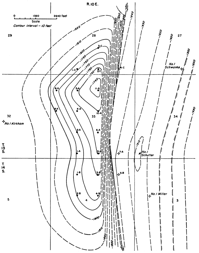
Several local elongated structural highs with their intervening saddles are located along the crest of the Alma anticline on the Viola. It is on one of these highs that the Davis Ranch pool is located. The highs vary considerably in the amount of closure as well as in areal extent.
Two more oil pools discovered since the Davis Ranch pool were found to be located on local structural highs on the Alma anticline. They are the Mill Creek pool opened by the discovery of oil in the Viola in the Skelly Oil Company No. 2 Thowe well in the SW SE NE sec. 2, T. 13 S., R. 10 E., completed September 29, 1950, and the Newbury pool in which oil was discovered in the Viola in the Skelly Oil Company No. 1 Fearon well located in the NW SW NE sec. 11, T. 11 S., R. 11 E., completed October 6, 1950. The wells were given an initial production of 3,000 and 254 barrels of oil per day, respectively.
To the west of the trend, the strata dip gently to the west into the deep syncline that lies between the Nemaha anticline on the west and the Alma anticline on the east. The average amount of dip is 120 feet per mile on the top of the Viola.
East of the Alma anticline the rocks dip sharply eastward with an average dip of about 350 feet per mile into another similar syncline. The deepest well, structurally speaking, thus far drilled in this syncline is the Ray Anderson No. 1 Morris well in sec. 36, T. 12 S., R. 10 E. where the top of the Viola was encountered at 1,952 feet below sea level. The axis of the syncline is essentially parallel to that of the Alma anticline and their relations, although on a smaller scale, are similar to the Nemaha anticline and its adjacent syncline to the east.
In eastern Wabaunsee County, the Viola has an average regional dip of 20 feet per mile to the northwest as is shown in Figure 3. In the Phillips and Ajax No. 1 McKnight well in sec. 16, T. 14 S., R. 12 E. the Viola was encountered at only 1,664 feet below sea level. This is the nearest to the surface that the Viola has been found in Wabaunsee County except in those wells which encountered the formation at higher levels along the Nemaha anticline.
Reverse faulting has taken place on the east flank of the local Davis Ranch structure. Possibly other faults of a similar nature occur on the flanks of the other local highs on the same trend, although they cannot be mapped from available subsurface data. Faulting may have occurred also along the east flank of the Nemaha anticline but here again sufficient data to establish faulting of any nature are lacking. The dip of the Pre-Cambrian surface on the eastern flank of the Nemaha anticline at present is locally about 1,000 feet per mile, or 11 degrees. There is no evidence that faulting has occurred but the deformation may have been accompanied by local faulting.
The discovery well for the Davis Ranch pool, the Carter Oil Company No. 1 Davis "A" well in the SW SE SW sec. 33, T. 13 S., R. 10 E., was drilled on an anticline mapped on surface rocks using the top of the Threemile limestone member of the Wreford formation as a datum plane. On the surface the anticline has a closure of more than 20 feet and is about 1 1/2 miles long and half a mile wide. The axis strikes almost due north and south with a slight inclination to the east. Subsurface data, assembled from later wells, reveal that the structure is a local high on the north-northeast trending Alma anticline which parallels the Nemaha anticline to the west.
At the top of the Viola the Davis Ranch anticline is at least 2 miles long and three-fourths mile wide, having a closure of approximately 80 feet (Fig. 4). The anticline is asymmetrical with an easterly dip of 350 feet per mile and a westerly dip of only 120 feet per mile on top of the Viola. The northern end of the structure seems to be more blunt with a plunge of 120 feet per mile on top of the Viola while on the southern end the plunge is only about 40 feet per mile.
On the east flank of the Davis Ranch anticline, the beds dip sharply into the adjacent parallel syncline where the top of the Viola is more than 1,950 feet below sea level (Fig. 4). East of the syncline the beds rise rapidly until they merge into the regional dip of 20 feet per mile.
The highest point at which the Viola has thus far been encountered on the Davis Ranch anticline is in the Carter Oil Company No. 11 Davis "A" well in the SW NW NE sec. 33, T. 13 S., R. 10 E. in which the formation was topped at 1,737 feet below sea level. The high point on the Mississippian is a quarter of a mile south in the Carter Oil Company No. 10 Davis "A" well in the SW SW NE sec. 33, T. 13 S., R. 10 E. where it was encountered at 1,049 feet below sea level. Apparently the highest point at the top of the Wreford at the surface is about half a mile farther south at the location where the discovery well was drilled. This indicates an apparent shift in the crest of the anticline from south to north with increasing depth from the surface to the top of the Viola. These relationships may be seen in Figures 4 and 5.
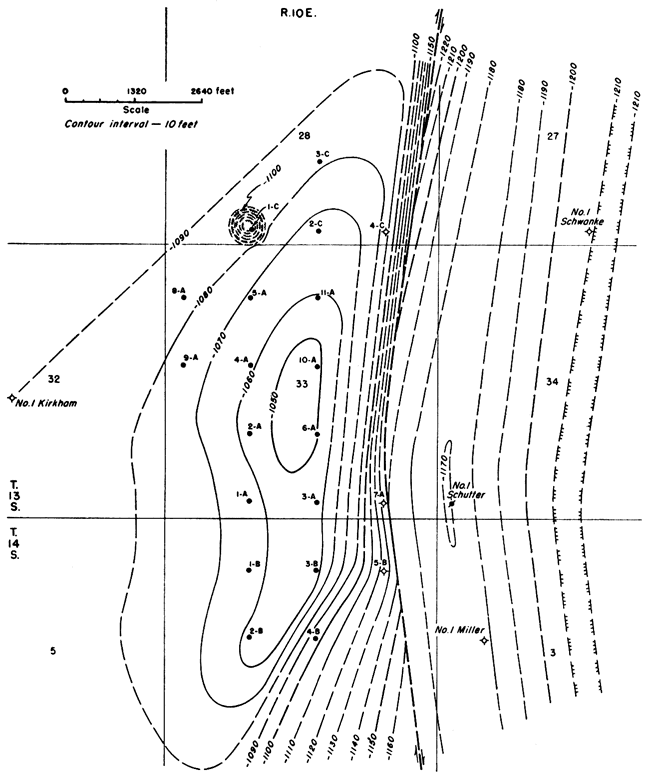
Figure 5--Map showing the structure of the Davis Ranch and Davis Ranch East pools contoured on top of the Mississippian beds.
Considerable controversy has arisen over the question of faulting on the east flank of the fold. Conclusive proof of the occurrence of a reverse fault is furnished by the samples and electric logs. In the Carter Oil Company No. 7 Davis "A" well, in the SW SE SE sec. 33, T. 13 S., R. 10 E., a dry hole, the fault plane has been penetrated in a position that gives a repetition of the Warsaw beds of Mississippian age (Pl. 2). In this well an abnormal thickness of 130 feet of Warsaw is present, compared to a thickness of 70 feet in the surrounding wells. A slight suggestion of slickensiding is indicated at 2,615 feet in the samples where the fault plane was encountered. A thickness of nearly 70 feet of Warsaw is present below the position of the fault plane which would indicate that the fault cuts the Warsaw in this well very close to the top of the formation. Almost the entire thickness of the Warsaw is present above the fault plane where the 60 feet of Warsaw has been repeated.
In the No. 5 Davis "B" well, also a dry hole, in the SW NE NE sec. 4, T. 14 S., R. 10 E., a quarter of a mile to the south of the No. 7 Davis "A" well, the fault plane was encountered in the Chattanooga shale where an abnormal thickness of 260 feet for this formation is present as compared to a normal thickness of about 185 feet (Pl. 2). The position of the fault plane in this well is not as apparent as it is in the well to the north. Due to the uniformity of the lithology of the Chattanooga in this area, irregularities in the samples or the electric log of this well are difficult to recognize. A very slight indication of slickensiding was seen at 2,905 feet in the samples. Evidences of slickensided fragments occur in the samples below this level but they are probably due to recirculation and caving and are not in place. A thickness of 140 feet of Chattanooga is present below the questionable position of the fault plane in this well. This indicates that the fault has cut the Chattanooga beds at a position just below the lowermost dolomite bed which occurs about 45 feet below the top of the formation and that 75 feet of Chattanooga immediately below the dolomite bed has been repeated.
In the Carter Oil Company No. 4 Davis "C" well located in the SW SE SE sec. 28, T. 13 S., R. 10 E., the fault plane was probably encountered in the Maquoketa shale (Pl. 2). This well penetrated 146 feet of Maquoketa, as compared to an average thickness of 80 feet in the neighboring wells. This indicates a repetition of nearly 70 feet of Maquoketa, almost complete repetition.
Because abnormal thickening occurs in three different formations within 1 1/4 miles, the possibility of thickening due to, deposition in a syncline must be discarded. It is not logical to expect increases in thickness of 60 feet or more in three different formations which elsewhere within the immediate area vary only slightly from their average thickness (Pl. 2). Inasmuch as these wells are the only ones which have penetrated the fault plane in the area of the pool, the exact position of the fault trace on top of the Viola, or on top of younger formations, cannot be located precisely. The same is true of the dip of the fault plane. The facts that the fault is a curving reverse fault and that the fault plane encounters the Maquoketa in the No. 4 Davis "C" well, the Warsaw in the No. 7 Davis "A" well, and the Chattanooga in the No. 5 Davis "B" well will, of necessity, place the fault trace on top of the Viola at a position somewhere between the three dry holes on the east and the neighboring producing wells on the west. The trace of the fault will be closer to the No. 4 Davis "C" well, where the Maquoketa is repeated, than it will to the two wells in which the Warsaw and Chattanooga have been repeated (Fig. 4).
The fault trace on the top of the Mississippian beds will fall at a position just east of the three dry holes with the trace being nearer to, the No. 7 Davis "A" well than to the wells to the north and south (Fig. 5).
The exact position of the fault trace on any bed cannot be indicated, however, due to the lack of knowledge concerning the dip of the fault plane. If the fault plane has a high angle of dip, the fault trace on the top of the Viola will lie very close to and just west of the dry holes while the trace on the top of the Mississippian beds will be very close to and just east of the dry holes. On the other hand, if the fault plane has a lower angle of dip, the trace of the fault on the top of the Viola will lie at a greater distance from the dry holes on the west and the trace on the top of the Mississippian will lie at a greater distance to the east of the dry holes. In any case the angle of dip of the fault plane must be greater than 25 degrees. An angle dip of any degree less than this amount would have caused the fault plane to cut the Viola, or higher beds, in the wells which lie 1,320 feet west of the dry holes where the fault plane was encountered.
As has been mentioned previously, the closure of the Davis Ranch anticline at the surface is approximately 20 feet while the closure on the top of the Viola is in the neighborhood of 100 feet. The amount of closure on formations between the Viola and the top of the Mississippian remains fairly constant, comparing closely with that on the top of the Viola. This is consistent with the concept that movement did not begin until just before the close of Mississippian time and before the start of the Pennsylvanian deposition. The interval of closure between these two horizons should remain the same under these conditions, except possibly for slight variations due to the incompetency of beds involved.
On the top of the Mississippian, however, the closure is only 70 feet. The amount of closure here at one time may have approached closely or may even have been as great as in the underlying beds. Pre-Pennsylvanian erosion, however, removed practically all indications of surface relief of the structure so that a nearly perfect plane existed just before Pennsylvanian deposition. The amount of erosion at that time exceeded the amount of folding so that an essentially level surface existed.
With the beginning of Pennsylvanian deposition and continued deformation the structural relief on top of the Mississippian beds was then preserved, indicating that at least 70 feet of vertical movement took place after the beginning of Pennsylvanian deposition.
From the top of the Mississippian beds to the base of the Wreford the amount of closure decreases in much the same manner as it has on top of the Mississippian. Disconformities at various horizons have reduced the amount of structural relief so that with additional deposition and further movement the amount of relief above the disconformity is not as great as that below the disconformity.
The depth of faulting is quite problematical. No subsurface criteria have as yet been encountered which would place the fault below the top of the Viola. The amount of throw involved increases with depth as is shown by the relationships in the three dry holes which cut the fault plane. In the No. 7 Davis "A" well a throw of 60 feet is indicated in the Warsaw while in the No. 5 Davis "B" well a throw of 75 feet is revealed in the Chattanooga. This gives an increase of 15 feet of throw in about 370 feet of depth. In the No. 4 Davis "C" well, 1 mile north of the No. 7 Davis "A" well, a throw of only 66 feet is indicated in the Maquoketa shale. Inasmuch as the Maquoketa is lower stratigraphically than the two horizons which are faulted in the No. 7 Davis "A" and the No. 5 Davis "B" wells, it would seem that the throw of the fault is decreasing to the north.
The age of the youngest beds which have been affected by the fault is again problematical. No indication of faulting can be seen at the surface. In all probability beds above the base of the Permian have not been displaced. Assuming that the amount of throw decreases upward in the same proportion that it increases downward, a simple proportion shows that displacement of beds has taken place approximately 1,500 feet above the position at which the fault plane has cut the Warsaw. This would place the upper limit of the fault somewhere in the Shawnee group of Upper Pennsylvanian age. Realizing that this is purely a theoretical manner of determining the limits of the fault, and that probably no fault existing today could have a proportion of this sort applied accurately, an error of hundreds of feet must be recognized as possible.
The major period of deformation for the Davis Ranch anticline occurred during the long erosional interval between the end of Mississippian deposition and the beginning of Pennsylvanian deposition. This is revealed by the closure on the anticline, which remains essentially the same at various intervals below the top of the Mississippian. Also the thicknesses of the units below the Mississippian, which remain approximately equal, indicate that little if any movement occurred before the end of Mississippian time.
Deformation elevated the Davis Ranch anticline about 40 feet after the close of Mississippian deposition. At the same time, the amount of erosion which occurred before Pennsylvanian deposition exceeded that of uplift so that before the Cherokee sea covered the area conditions closely approached base level, for Mississippian beds younger than the Spergen have been eroded from the crest of the anticline but are present in the synclines to the east and west of the structure. The St. Louis and Spergen have been beveled and are overlapped on the flanks of the anticline by the Cherokee shale.
Movement of the fold continued through Pennsylvanian time and into the Permian at least until after the time of Wreford deposition. The interpretation of movements that occurred during these periods of time are based upon the relative thicknesses of three sequences of rocks. The thickness of these intervals ranges from about 600 to 950 feet. The four datum planes used are (1) the top of the Mississippian limestones, (2) the base of the Hertha limestone at the base of the Kansas City group, (3) the top of the Topeka limestone at the top of the Shawnee group, and (4) the base of the Grenola limestone of the Council Grove group of the Permian System.
A difference of 30 feet in the thickness of the sequence between the top of the Mississippian limestones and the base of the Hertha limestone has been measured from the crest of the Davis Ranch anticline to a point in the syncline to the east. The difference in the thickness of the sequence between the base of the Hertha and the top of the Topeka is only 25 feet, while the difference in the thickness of the interval from the top of the Topeka to the base of the Grenola is 10 feet.
Inasmuch as the average thickness of these intervals ranges from only about 600 feet to approximately 950 feet, a fairly accurate indication of the magnitude of deformation that took place during each interval can be assumed. Deformation was quite active during the first period but in the second period, from the beginning of Hertha time to the end of Topeka time, the magnitude of deformation decreased slightly until the third period when deformation was considerably decreased.
No accurate information concerning deformation during late Permian time can be obtained, because no rocks of that age are present in the area of the pool. However, movements certainly continued past Wreford time and probably into late Permian time. Possibly there was a slight amount of movement even as late as early Cretaceous time.
The age of faulting is more difficult to determine. A fault is usually considered to be younger than the youngest rocks which it intersects. If this statement is accepted, the time of faulting must be later than middle Shawnee (Late Pennsylvanian) time because theoretically the uppermost beds which have been affected by the fault are those of the Shawnee. On the other hand, if the faulting occurred simultaneously with the folding of the beds, the age of the fault would be in the interval from the end of Mississippian time to about the middle of Shawnee time, the increment of displacement decreasing upward in proportion to the magnitude of folding. If this theory is accepted, certainly no displacement took place after Shawnee time.
Information of the type presented in this section is generally not included in a geological report. However, because of the importance of the Davis Ranch pool and the possibility of such information being an aid to future exploration in the Forest City basin, it is believed that many persons will be interested in some of the engineering aspects of the pool.
The discussion on oil analyses should be of particular interest to many because one of the most important factors determining the price of a barrel of crude oil is its physical characteristics. In general, the price of a barrel of crude oil is determined by the amount of gasoline that can be extracted from it. The discussion of reservoir pressures will be of particular interest to those who will plan production facilities for possible future fields in this area.
The Kansas Geological Survey keeps no record of information concerning producing zone and crude oil characteristics for the State of Kansas. For this information on the Davis Ranch pool we are indebted to W. F. Eiting, Jr., Chief Petroleum Engineer of the Carter Oil Company.
Most of the production from the Davis Ranch pool has come from the Viola dolomite. Its porosity is of the intercrystalline type, perfectly formed dolomite rhombohedrons being cemented together without definite arrangement. As a result, the voids are quite heterogeneous in both size and shape. In most cases the crystal edges are in contact with one another so that the crystal faces are separated. This arrangement gives adequate pore space to form continuous communicating channels which the fluid can penetrate and which can act as a storage reservoir. Figure 6 shows the thickness of the porous zone at the top of the Viola dolomite above the water-oil contact at 1,800 feet below sea level.
Figure 6--Map showing the thickness of the oil-saturated porous zone at the top of the productive Viola dolomite.
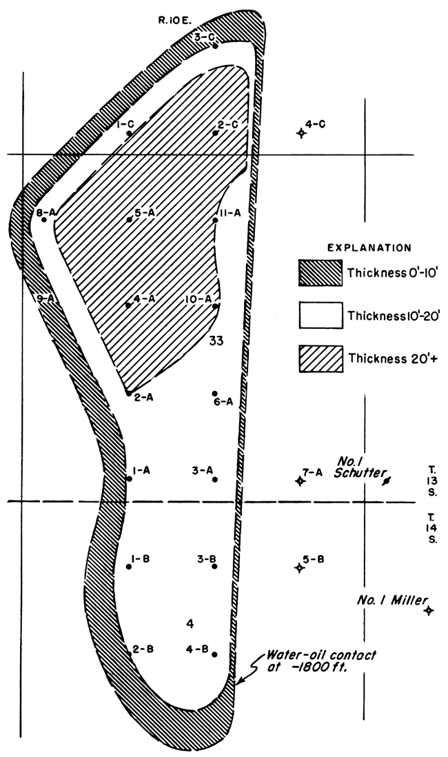
Available core analysis data indicate an average porosity of 14.7 percent. Measured permeabilities to dry air are as much as 7,640 millidarcys; the weighted average permeability per net pay above 10 millidarcys is 1,192 millidarcys.
Drawdown tests on the first five wells gave an average productivity index of 5.82 barrels of oil per day for each pound per square inch drop in bottom-hole pressure. The initial static bottom-hole pressure in the Viola was 1,138 psia. at 1,784 feet below sea level. Pumping tests on 16 of the wells gave information concerning fluid levels (Table 2). The rates indicated are not necessarily capacity rates. Production statistics for the Davis Ranch pool are given in Table 3.
Table 2--Fluid levels and pumping rates for 16 wells in the Davis Ranch pool.
| Well | Pumping rate, bbls. per 24 hours |
Fluid level, in feet above top of Viola, by echometer |
|---|---|---|
| No. 1 G. H. Davis "A" | 497 | 2,381 |
| No. 2 G. H. Davis "A" | 484 | 2,461 |
| No. 3 G. H. Davis "A" | 510 | 2,636 |
| No. 4 G. H. Davis "A" | 508 | 2,852 |
| No. 5 G. H. Davis "A" | 474 | 2,718 |
| No. 6 G. H. Davis "A" | 511 | 2,387 |
| No. 8 G. H. Davis "A" | 465 | 2,778 |
| No. 9 G. H. Davis "A" | 483 | 2,432 |
| No. 10 G. H. Davis "A" | 534 | 2,770 |
| No. 11 G. H. Davis "A" | 469 | 2,792 |
| No. 1 G. H. Davis "B" | 503 | 2,675 |
| No. 2 G. H. Davis "B" | 490 | 2,792 |
| No. 3 G. H. Davis "B" | 494 | 2,762 |
| No. 4 G. H. Davis "B" | 473 | 2,666 |
| No. 1 G. H. Davis "C" | 497 | 2,596 |
| No. 2 G. H. Davis "C" | 599 | 2,816 |
Table 3--Production statistics for the Davis Ranch pool through December 1950.
| Month | Production, bbls. oil |
Cumulative production, bbls. oil |
|---|---|---|
| 1949 | ||
| May | 1,853 | 1,853 |
| June | 1,158 | 3,011 |
| July | 865 | 3,876 |
| August | 1,444 | 5,320 |
| September | 4,700 | 10,020 |
| October | 10,727 | 20,747 |
| November | 15,308 | 36,055 |
| December | 13,491 | 49,546 |
| 1950 | ||
| January | 21,739 | 71,285 |
| February | 27,014 | 98,299 |
| March | 26,940 | 125,239 |
| April | 29,566 | 154,805 |
| May | 30,300 | 185,105 |
| June | 30,422 | 215,527 |
| July | 32,224 | 247,751 |
| August | 32,239 | 279,990 |
| September | 28,516 | 308,506 |
| October | 32,451 | 340,957 |
| November | 25,321 | 366,278 |
| December | 23,916 | 390,194 |
One subsurface oil sample obtained from the Davis Ranch pool has been analyzed by the Carter Oil Company. This sample was obtained under reservoir conditions of pressure and temperature from the No. 1 G. H. Davis "A" well on May 27, 1949. The results of the analysis are given in Table 4.
Table 4--Analysis of oil from the Carter Oil Company No. 1 G. H. Davis "A" well (Sample taken May 27, 1949, from a depth of 3,197 feet, 1,762 feet below sea level. Analysis by Carter Oil Company)
| General Characteristics | |
|---|---|
| Saturation pressure | 194 psia. at 125°F. |
| Compressibility | 0.64 percent per 1,000 psi. at 125°F. |
| Thermal expansion | 0.044 percent per degree F. at 125°F. |
| Absolute viscosity | 16.327 centipoises at 0 psi. and 125°F. |
| Gas-oil ratio | 0.5 cu. ft. per bbl. of surface oil |
| Shrinkage | Not measurable |
| Gravity of stock tank oil | 27.7° A.P.I. |
| Hydrocarbon analysis | ||
|---|---|---|
| Component | Liquid volume, percent |
Mole, percent |
| Iso pentane | 0.15 | 0.45 |
| N pentane | 0.36 | 1.16 |
| N hexane | 2.24 | 6.16 |
| Heptanes plus | 97.25 | 92.23 |
| 100.00 | 100.00 | |
The reservoir oil found in the Davis Ranch pool is quite different in nature from the oils found in most places in the world, but is similar to some others found in Kansas. The extraordinary characteristic of the oil is the almost complete absence of hydrocarbons which are gaseous at atmospheric conditions. The hydrocarbon analysis (Table 4) shows that no hydrocarbons lighter than the pentanes are present. The gas-oil ratio reported is only half a cubic foot of gas per barrel of stock tank oil. In spite of the absence of the lighter hydrocarbons the density of the stock-tank oil is fairly low, and it sells at a good price on the market.
Analyses made by the Carter Oil Company of two samples of stock-tank oil are given in Table 5. The U.S. Bureau of Mines Hempel distillation indicates that approximately 13.9 percent of the crude oil can be made into gasoline. The crude should also yield another 12.7 percent as kerosene. The average gravity of the two samples is 27° A.P.I. at 60°F.
Table 5--Analyses of two samples of stock-tank oil from the Davis Ranch pool (Analyses by the Carter Oil Company).
| General characteristics | No. 2 G. H. Davis "A" |
No. 1 G. H. Davis "A" |
|
|---|---|---|---|
| Specific gravity | 0.8933 | 0.8916 | |
| Sayboldt Universal viscosity at 100°F. | 145.1 sec. | 168.2 sec. | |
| Pour point | Below -20°F. | Below -20°F. | |
| A.P.I. gravity | 26.9° | 27.2° | |
| Percent sulfur | 0.47 | 0.62 | |
| Distillation, U.S. Bureau of Mines, Hempel Method. | |||
| Temperature | |||
| Degrees C | Degrees F. | ||
| Atmospheric distillation | |||
| 50-75 | 122-167 | 1.4* | 0.7* |
| 75-100 | 167-212 | 1.0 | 1.2 |
| 100-125 | 212-257 | 2.6 | 2.8 |
| 125-150 | 257-302 | 2.7 | 2.9 |
| 150-175 | 302-347 | 2.8 | 3.2 |
| 175-200 | 347-392 | 3.2 | 3.3 |
| 200-225 | 392-437 | 3.4 | 3.4 |
| 225-250 | 437-482 | 4.7 | 3.7 |
| 250-275 | 482-527 | 5.3 | 4.9 |
| Vacuum distillation at 40 mm | |||
| Up to 200 | Up to 392 | 7.9 | 4.7 |
| 200-225 | 392-437 | 5.2 | 6.2 |
| 225-250 | 437-482 | 4.9 | 4.9 |
| 250-275 | 482-527 | 4.5 | 4.9 |
| 275-300 | 527-572 | 5.8 | 5.9 |
| *Volume, percent of cut. | |||
Jewett, J. M. (1945) Stratigraphy of the Marmaton group, Pennsylvanian, in Kansas: Kansas Geol. Survey, Bull. 58, pp. 1-148, pls. 1-4. [available online]
Lee, Wallace (1943) The stratigraphy and structural development of the Forest City basin in Kansas: Kansas Geol. Survey, Bull. 51, pp. 1-142, figs. 1-22. [available online]
Lee, Wallace, and Payne, T. G. (1944) McLouth gas and oil field, Jefferson and Leavenworth Counties, Kansas: Kansas Geol. Survey, Bull. 53, pp. 1-193, figs. 1-20, pls. 1-10. [available online]
Moore, R. C. (1949) Divisions of the Pennsylvanian System in Kansas: Kansas Geol. Survey, Bull. 83, pp. 1-203, figs. 1-37. [available online]
Moore, R. C., and others (1950) The Kansas rock column: Kansas Geol. Survey, Bull. 89, pp. 1-132, figs. 1-52. [available online]
Kansas Geological Survey, Geology
Placed on web Jan. 14, 2009; originally published in April 1951.
Comments to webadmin@kgs.ku.edu
The URL for this page is http://www.kgs.ku.edu/Publications/Bulletins/90_2/index.html