Kansas Geological Survey, Bulletin 64, part 3, originally published in 1946
Prepared by the State Geological Survey of Kansas, the United States Geological Survey, the Division of Sanitation of the Kansas State Board of Health and the Division of Water Resources of the Kansas State Board of Agriculture. Publication costs were paid by the Kansas State Board of Health.
Originally published in 1946 as Kansas Geological Survey Bulletin 64, part 3. This is, in general, the original text as published. The information has not been updated. An Acrobat PDF version (8 MB) is also available; plate available separately.
This report describes the geology and ground-water conditions in a part of Elm Creek Valley, Barber County, Kansas. Elm Creek is a small intermittent stream tributary to Medicine Lodge River. The area described includes about 23 square miles bordering the creek in the vicinity of Medicine Lodge. A small oil field is located along the east side of the valley about three miles northeast of Medicine Lodge. This report is concerned with the groundwater conditions in the lower part of the valley and the extent to which oilfield brine affects the quality of the ground water.
The Cedar Hills sandstone of Permian age comprises the bedrock beneath the alluvium in this area, and is composed of about 180 feet of red, silty, fine-grained sandstone interbedded with softer red shale and siltstone. The terrace deposits are of alluvial origin and probably are equivalent to the Gerlane formation. The alluvium consists of unconsolidated stream-deposited materials ranging in thickness from a featheredge along the valley sides to 68 feet at the deepest test hole,
The analyses of 51 samples of water collected from test holes and wells show that the quality of the water in the alluvium varies according to location in the valley. In general the water is of better quality near the creek and more highly mineralized near the edges of the valley where water from the Cedar Hills sandstone enters the alluvium. The ground water is more highly mineralized near the base of the alluvium than near the surface. Along parts of the east side of the valley the ground water is affected by intrusion of oil field brine. The possibility of further salt-water encroachment under pumping conditions is noted. It is suggested that pumping tests be conducted prior to the development of ground-water supplies In Elm Creek Valley. The chemical character of the ground water is discussed in detail.
Logs of 36 test holes in the area are given, including 25 test holes drilled by the State Geological Survey. Chemical analyses of water samples collected are included in the report.
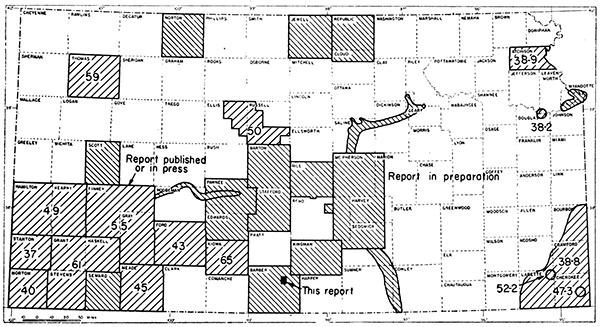
The area described in this report includes about 23 square miles bordering Elm Creek in northeastern Barber County, Kansas, in the vicinity of Medicine Lodge (Fig. 1). Elm Creek is a small intermittent stream tributary to Medicine Lodge River which it joins just south of the City of Medicine Lodge. A small oil field, known as the Whelan pool, is located along the east side of Elm Creek Valley about 3 miles northeast of Medicine Lodge. This report is concerned with the ground-water conditions in the lower part of Elm Creek Valley and the extent to which oil-field brine from the. Whelan pool affects the quality of the ground water.
Figure 1--Index map of Kansas showing area covered by this report and areas for which cooperative ground-water reports have been published or are in preparation.
A cooperative investigation of the general geology and hydrology of Barber County was started by Frank Byrne of the Geological Survey in 1941, but was suspended when Mr. Byrne entered the armed forces. It is planned that this general study will be completed as soon as practicable.
Study of Elm Creek Valley was begun in August, 1945, by the United States Geological Survey and the State Geological Survey of Kansas at the suggestion of and in direct cooperation with Paul D. Haney, director, and Ogden S. Jones, geologist, of the division of Sanitation of the Kansas State Board of Health and with the cooperation of the Division of Water Resources of the Kansas State Board of Agriculture.
The field work in this area was done mainly during the period from August 1 to September 12, 1945. Using the portable hydraulic-rotary drilling machine owned by the State Geological Survey, C. K. Bayne and O. S. Fent, geologists, and George Yeckel, helper, drilled 25 test holes in the alluvium of Elm Creek Valley and in the Cedar Hills sandstone bordering the alluvium, The locations of the test holes are shown on Plate 1. Samples of the material penetrated by the drill were collected and are described in the logs at the end of this report.
Residents of this area were very cooperative in permitting test drilling on their land. D. C. Chads, Mayor of the City of Medicine Lodge, was very helpful to the investigation in many ways and made available many data concerning the present city water-supply system. Logs of several test holes drilled for the City of Medicine Lodge are included in this report through the courtesy of the city and the Layne-Western Company.
The manuscript for this report has been reviewed critically by several members of the Federal Geological Survey; R. C. Moore, state geologist and director of research, and J. C. Frye, executive director of the State Geological Survey of Kansas; Paul D. Haney, director, and Ogden S. Jones, geologist, of the Division of Sanitation, Kansas State Board of Health; and George S. Knapp, chief engineer of the Division of Water Resources, Kansas State Board of Agriculture.
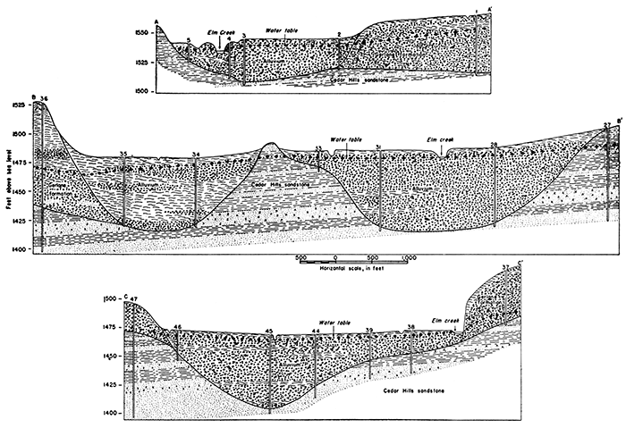
This area is under lain in part by Permian red sandstone and shale and in part by unconsolidated deposits of sand, silt, and gravel of Pleistocene and Recent age. Elm Creek has eroded and removed from its valley most of the unconsolidated material comprising the Gerlane formation and has carved, at some earlier time, a deeper valley in the Permian bedrock than it now occupies. This deeper valley subsequently has been filled with sand, gravel, and silt derived from the lithologically similar Pleistocene deposits which are extensive north of this area. The relationship of the present stream to its older valley and to the Gerlane formation and Cedar Hills sandstone as revealed by test drilling is shown in the geologic sections across Elm Creek Valley (Fig. 2).
Figure 2--Geologic profiles across Elm Creek Valley along lines A-A', B-B', C-C' on Plate 1.
The Cedar Hills sandstone comprises the bedrock beneath the alluvium in this area, and is composed of about 180 feet of red, silty, fine-grained sandstone interbedded with softer red shale and siltstone. These beds are eroded easily and the topography of the country bordering Elm Creek is characterized by canyons cut between rounded hills and ridges. As described by Norton (1939, p. 1789):
The Cedar Hills sandstone includes a prominent white sandstone at the base and top, the latter containing "snow balls" of concretionary white gypsum. Softer, more shaly, red siltstones separate the more massive sandy beds and serve to break the formation into recognizable layers.
Two beds (of sandstone) in particular are more readily identified than others, save the top and basal beds: the first 127 feet below the top weathers into forms compared to haystacks, and the second, 100 feet below the top, weathers to more smoothly rounded outcrops and benches of lighter colored appearance which makes possible its correlation over considerable distances.
The beds comprising the Cedar Hills sandstone contain gypsum. and other salts in some amount, generally as disseminated fine particles or as small crystalline aggregates. The sandstone beds contain 1 to 8 percent ferric oxide (Fe2O3) (Clarke and Washington, 1924, p. 29) and the shale and siltstone contains considerably more. The iron oxide in these beds imparts the characteristic red color to the formation.
Present classification of the State Geological Survey of Kansas places the Permian Cedar Hills sandstone near the middle of the Nippewalla group, Leonardian series.
The fine-grained sandstone beds in the Cedar Hills supply water to farm wells in quantities sufficient for domestic and stock use. In this area no wells yield large quantities of ground water from the Cedar Hills sandstone, and the physical character of the material comprising this formation is such that large yields from wells could not be expected. Analyses (Table 3). show that the water contained in the sandstone is highly mineralized and very hard.
The terrace deposits which occur sporadically along the edge of Elm Creek Valley probably are equivalent to the Gerlane formation which Knight (1934, p. 91) named and described from exposures southeast of this area near the town of Gerlane in Barber County. The deposit, according, to Knight:
. . . is of alluvial origin, the material having been derived from the Permian and Tertiary formations in the area. The Gerlane occurs both as a valley filling and as surface wash. The former type is best developed in the larger valleys; giving them smooth broad floors. Where partly removed by erosion, the Gerlane forms terraces along the sides of the valleys. The surface-wash phase of the formation covers much of the inter-valley areas of the lower slopes.
In northern Barber County deposits of sand, silt, and gravel of Pleistocene age occur extensively and probably are continuous with similar deposits in Kiowa County which have been correlated with the Meade formation by Latta (1946). These deposits are older and occur at a higher altitude than the Gerlane formation. Streams flowing through this area in late Pleistocene time eroded and removed the older Pleistocene deposits and in turn deposited material reworked from these beds and from the Permian rocks to form the Gerlane formation.
From the geologic profiles shown on Figure 2 it may be inferred that the Gerlane formation occurs extensively in this area. However, in many places along the border of Elm Creek Valley these deposits are absent or are very thin, and where present, as along the lines of the profiles, the Gerlane formation becomes thinner rapidly in each direction from Elm Creek. Because of its sporadic occurrence and small hydrologic importance, the areal extent of the Gerlane formation was not mapped in this area.
In places where sufficient material remains, the Gerlane formation supplies water to farm and stock wells. A few small springs issue from this formation in the northeastern part of the area and supply water to small stock ponds. Only small quantities of water are available locally from the Gerlane formation. The quality of water contained in the Gerlane is better than the water in other formations in this area.
The alluvium in the valley of Elm Creek is of Recent age and consists of unconsolidated stream-deposited materials ranging in thickness from a featheredge along the valley sides to 68 feet at test hole 31. Samples collected from the test holes show that the alluvium consists of clay, silt, sand, and gravel and contains some large pebbles and cobbles. In general, the alluvium contains coarser material near the center of the valley and finer particles near the edge. Fine grains and particles of gypsum derived from the Cedar Hills sandstone and other Permian rocks occur in beds of silt in the alluvium. Sand dunes cover the surface in small areas along the east side of Elm Creek between test holes 14 and 28 (Pl. 1). The character of the material comprising the alluvium is shown graphically in Figure 2 and is described in the logs of test holes at the end of this report.
The gradient of that part of Elm Creek shown on Plate 1 is about 15 feet per mile. Test drilling indicated that the gradient of the bedrock floor of the valley is about 25 feet per mile. This decrease in gradient during the development of Elm Creek probably has been progressive and has been a factor contributing to the deposition of alluvium in the valley. A few miles north of this area no alluvium has been deposited in the valley of Elm Creek and the creek is still cutting downward.
The alluvium is the source of water for domestic and stock wells in this area and also for the City of Medicine Lodge. The city supply is derived from an infiltration gallery and from 3 shallow wells (numbers 9, 10, and 11, Pl. 1). The average daily water consumption by the city is about 500,000 gallons a day and peak consumption is probably about 1,000,000 gallons a day. The quantity of water that the alluvium will yield to wells in this area is not known, but it is believed that 1,000,000 gallons a day may be withdrawn safely from properly constructed wells penetrating the thickest sections (as near test hole 31).
The analyses of water samples collected from test holes and wells show that the chemical quality of the ground water contained in the alluvium in the valley varies from place to place. In general, the quality is better near Elm Creek and more highly mineralized near the edges of the valley where water from the Cedar Hills sandstone enters the alluvium. Along the east side of Elm Creek between test holes 14 and 20 ground water in the alluvium is brackish owing to the intrusion of oil-field brine. The chemical quality of the ground water is discussed in detail below.
The following discussion of the Whelan oil pool has been adapted, in part, from bulletins of the State Geological Survey of Kansas relating to exploration for oil and gas in western Kansas (Ver Wiebe, 1938, 1939, 1940, 1941, 1942, 1943, 1944, 1945, and 1946).
The Whelan oil pool was discovered in August, 1934, by the Lario Oil and Gas Company well on the Whelan Ranch in sec. 32, T. 31 S., R. 11 W., along the east side of Elm Creek Valley near the City of Medicine Lodge. Oil was found from 4,355 to 4,384 feet in the residual rocks at the top of the Mississippian limestone in the zone known as the "Chat". A considerable quantity of water was encountered with the oil, but the discovery well was plugged back and made into a producer. By the end of 1945, 20 wells located in an irregular area of about 700 acres in sees, 29, 30, 31, and 32, T. 31 S., R. 11 W. were producing.
The production of oil in the Whelan pool has increased generally since discovery. The number of wells, annual production, and cumulative production through 1945 are given in Table 1.
Table 1--Data pertaining to production of oil from the Whelan pool
| Year | Number of Wells | Annual production (barrels) |
Cumulative production (barrels) |
|---|---|---|---|
| 1934-1937 incl. | 5 | -- | 102,812 |
| 1938 | 8 | 74,310 | 177,122 |
| 1939 | 9 | 66,503 | 243,625 |
| 1940 | 15 | 97,175 | 340,880 |
| 1941 | 18 | 161,657 | 502,457 |
| 1942 | 18 | 198,231 | 700,688 |
| 1943 | 19 | 190,662 | 891,350 |
| 1944 | 19 | 239,110 | 1,130,460 |
| 1945 | 20 | 207,455 | 1,337,915 |
In most oil fields in Kansas oil and brine occur together or in proximity in the reservoir rocks and are pumped to the surface as a mixture. The oil and water usually are separated at the field in batteries of tanks known as "separators" before the oil is shipped to refineries. Disposal of the brine after separation is effected in several different ways.
The oil-brine production ratio at this field is not known to the writers, but an estimate of the quantity of brine produced daily at the time of this investigation was made by Hal C. Smith, field assistant, Oil Field Section, Kansas State Board of Health. Mr. Smith, who is experienced in brine-disposal problems, estimated that in August, 1945, the quantity of brine produced from wells in the Whelan pool was about 500 barrels (21,000 gallons) a day (Personal communication). If this figure may be taken as a fair average, the total annual production of brine from this pool was about 7.5 million gallons in 1945.
The Oil-Field Section, Division of Sanitation, Kansas State Board of Health, is charged with the responsibility of safeguarding the fresh underground and surface water supplies of Kansas from contamination by oil-field brines, and it is the policy of that agency to encourage the use of deep disposal wells to return the brines of the state to suitable subsurface formations (Jones, 1945).
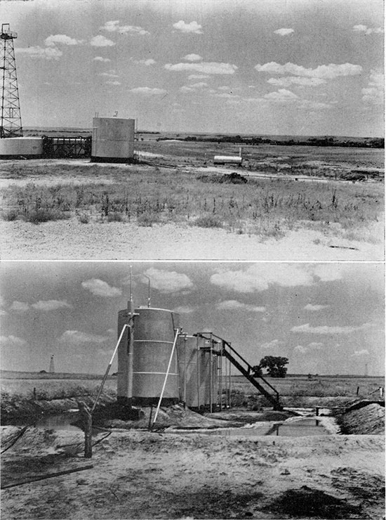
Brine produced with the oil from the Whelan pool flows from separator tanks directly to disposal ponds (Pl. 2) where it remains until carried away by heavy rainfall from the ponds constructed along ravines in the shale, or until it seeps downward into the more pervious alluvium. In either case the brine moves in the direction of the slope of the water table toward Elm Creek.
Plate 2--A, Drainageway (right) from brine-disposal pond toward Elm Creek (background), B, Separator tanks and brine-disposal pond in the alluvium of Elm Creek Valley.
Data concerning ground-water conditions in this area were obtained from 48 test holes and wells, and information pertaining to them is given in table 2.
Table 2--Locations, altitudes, and water levels in test holes and wells
| No. on Plate 1 |
Location | Source of dataa |
Surface altitude (feet) |
Depth to water level (feet) |
|---|---|---|---|---|
| 1 | T. 31 S., R. 11 W. SE NW sec. 19 |
T | 1,566.9 | 12.1 |
| 2 | T. 31 S., R. 11 W. NE cor. sec. 24 |
T | 1,546.6 | 6.2 |
| 3 | T. 31 S., R. 12 W. SW NE sec. 24 |
T | 1,545.6 | 6.3 |
| 4 | T. 31 S., R. 12 W. SW NE sec. 24 |
T | 1,542.4 | 5.4 |
| 5 | T. 31 S., R. 12 W. SE NW sec. 24 |
T | 1,540.9 | 5.5 |
| 6 | T. 31 S., R. 11 W. NW SW sec. 20 |
S | ||
| 7 | T. 31 S., R. 12 W. NE SW NE sec. 24 |
S | 1,530.0 | |
| 8 | T. 31 S., R. 12 W. SW SW SE sec. 24 |
W | ||
| 9 | T. 31 S., R. 12 W. NW NE sec. 25 |
W | ||
| 10 | T. 31 S., R. 12 W. NW NE sec. 25 |
W | 1,525 | 3 |
| 11 | T. 31 S., R. 12 W. NW NE sec. 25 |
W | ||
| 12 | T. 31 S., R. 11 W. SW cor. NW sec. 30 |
W | ||
| 13 | T. 31 S., R. 12 W. SW NE sec. 25 |
W | ||
| 14 | T. 31 S., R. 11 W. SW SW sec. 30 |
T | 1,515,4 | 4.9 |
| 15 | T. 31 S., R. 11 W. SE SE sec. 30 |
W | ||
| 16 | T. 31 S., R. 11 W. NE NW sec. 31 |
T | 1,511.3 | 6.0 |
| 17 | T. 31 S., R. 11 W. NE NW sec. 31 |
T | 1.509.4 | 8.2 |
| 18 | T. 31 S., R. 11 W. SW NE sec. 31 |
T | 1,505.4 | 8.2 |
| 19 | T. 31 S., R. 11 W. SE NE sec. 31 |
T | 1,503.3 | 7.2 |
| 20 | T. 31 S., R. 11 W. NW SE sec. 31 |
T | 1,500,4 | 5,8 |
| 21 | T. 31 S., R. 12 W. NE SE sec. 35 |
W | 1,568.7 | 51.2 |
| 22 | T. 31 S., R. 11 W. NW SW SW sec. 32 |
W | 1,508.5 | 9.2 |
| 23 | T. 32 S., R. 11 W. NE cor. NW NW sec. 6 |
TL | ||
| 24 | T. 32 S., R. 11 W. SE NW NW sec. 6 |
TL | 1 | |
| 25 | T. 32 S., R. 11 W. Cen. SE NW sec. 6 |
TL | 4 | |
| 26 | T. 32 S., R. 11 W. SE SW NW sec. 6 |
TL | 1 | |
| 27 | T. 32 S., R. 11 W. SE NE sec. 6 |
T | 1,505.5 | 14.7 |
| 28 | T. 32 S., R. 11 W. NE NW SE sec. 6 |
T | 1,487.9 | 6.0 |
| 29 | T. 32 S., R. 11 W. SW NE sec. 6 |
S | 1,479 | |
| 30 | T. 32 S., R. 11 W. SE cor. NW sec. 6 |
TL | 5 | |
| 31 | T. 32 S., R. 11 W. NE SW sec. 6 |
T | 1,484.5 | 4.9 |
| 32 | T. 32 S., R. 11 W. SW SE NW sec. 6 |
TL | 4 | |
| 33 | T. 32 S., R. 11 W. NW NE SW sec. 6 |
T | 1,483.4 | 5.2 |
| 34 | T. 32 S., R. 12 W. SE NE sec. 1 |
T | 1,479.7 | 7.7 |
| 35 | T. 32 S., R. 12 W. SW NE sec. 1 |
T | 1,480,5 | 12,0 |
| 36 | T. 32 S., R. 12 W. NW SE sec. 1 |
T | 1,527.1 | 58.5 |
| 37 | T. 32 S., R. 11 W. NE NW sec. 7 |
T | 1,525.8 | 38.4 |
| 38 | T. 32 S., R. 11 W. NE NW NW sec. 7 |
T | 1,473.0 | 4.3 |
| 39 | T. 32 S., R. 11 W. NW NW sec. 7 |
T | 1,470.4 | 3.4 |
| 40 | T. 31 S., R. 12 W. SE cor. sec. 1 |
TL | 2 | |
| 41 | T. 31 S., R. 12 W. SE SE SE sec. 1 |
TL | 5 | |
| 42 | T. 31 S., R. 12 W. SW SE SE sec. 1 |
TL | 5 | |
| 43 | T. 31 S., R. 12 W. SW SE SE sec. 1 |
TL | 5 | |
| 44 | T. 32 S., R. 12 W. NE NE sec. 12 |
T | 1,469.5 | 3.8 |
| 45 | T. 32 S., R. 12 W. NW NE NE sec. 12 |
T | 1,468.9 | 4.7 |
| 46 | T. 32 S., R. 12 W. Cen. NW NE sec. 12 |
T | 1,472.8 | 4.7 |
| 47 | T. 32 S., R. 12 W. NW cor. NE sec. 12 |
T | 1,496.5 | |
| 48 | T. 32 S., R. 12 W. SW NW NW sec. 12 |
TL | 3 | |
| aT, test hole drilled by State Geological Survey; TL, test hole drilled by Layne-Western Company; W, water well; S, surface-water sampling station. |
||||
The depth to water in the alluvium of Elm Creek Valley is less than 10 feet in most places. The depth to water is greater in parts of the area underlain by the Gerlane formation and Cedar Hills sandstone, being as much as 58 feet below land surface. In general, the slope of the water table is toward Elm Creek, and the water-table contours shown on Plate 1 indicate that Elm Creek is a gaining stream throughout its course in this area. The slope of the water table is variable, but is about 20 feet per mile. The fact that the movement of water from the Whelan oil pool is southwestward toward Elm Creek is noteworthy. Ground water contained in the Cedar Hills sandstone and the Gerlane formation moves down gradient toward Elm Creek.
Recharge is the term used to denote the addition of water to the ground-water reservoir and may be accomplished in several ways. The ultimate source of ground water in the alluvium, Gerlane formation, and Cedar Hills sandstone is rainfall on this and near-by areas. Once the water becomes a part of the ground-water body it moves in the direction of the slope of the water table, later to be discharged at some point down gradient.
Ground water in the alluvium is derived from precipitation on the area underlain by alluvium, from the flood water of Elm Creek, from surface-water runoff from the valley sides which flows down _ the small creeks and ravines and deploys on the surface of the valley before reaching Elm Creek, from percolation of ground water from the Cedar Hills sandstone and Gerlane formation toward Elm Creek, and to a minor extent from oil-field brine.
The sandy soil in Elm Creek Valley and the proximity of the water table to the surface are factors conducive to recharge, but the quantity of recharge to the ground-water reservoir in this area is not known. Study of records of the fluctuation of the water table as observed in wells over a period of several years would be necessary before a reasonable estimate of this quantity could be made.
When water derived from precipitation or other sources reaches the zone of saturation it moves in the direction of the slope of the water table, and remains a part of the ground-water body until removed or discharged by some natural or artificial means. Discharge of ground water may be accomplished in several ways. Water may be removed from the aquifer by evaporation, by transpiration, by seepage into streams, by discharge from springs, wells, or infiltration galleries. All of these methods of discharge are operative singly or in combination in this area. Over a period of years the quantity of ground-water discharge is approximately equal to the quantity of recharge.
As is noted above, the depth to water is small in most parts of the valley, and much of the ground water is discharged through transpiration and evaporation, especially during summer months. Much of the water flowing in Elm Creek is derived from seeps and small springs along the banks and represents ground-water discharge. During periods of drought the ground-water level is lowered and the flow in Elm Creek ceases.
Water pumped from wells in the alluvium and water derived from the infiltration gallery beneath Elm Creek to supply the City of Medicine Lodge comprise the largest withdrawal o{ groundwater. The infiltration gallery consists of porous tile laid beneath the bed of Elm Creek, and water which enters the tile flows by gravity through a pipe line to the city. The location of the pipe line is shown on Plate 1. Three shallow gravel-packed wells (numbers 9, 10, and 11) in the alluvium are used to supplement the supply from the infiltration gallery during periods of drought or whenever the gallery is in need of repair. The average withdrawal of water by the city is about 500,000 gallons a day. The maximum quantity of water used by the city on anyone day is not known, but is probably about 1,000,000 gallons.
The chemical character of the ground waters in this area is shown by analyses of 51 samples of water from test holes, wells, oil wells, and from Elm Creek given in Table 3. Samples of water were taken from more than one depth at several of the test holes. The analyses, which were made by Howard A. Stoltenberg in the Water and Sewage Laboratory of the Kansas State Board of Health, show only the dissolved mineral content of the waters and do not in general indicate the sanitary condition of the waters. The constituents given were determined by the methods used by the United States Geological Survey.
Table 3--Analyses of water from test holes and wells in Elm Creek Valley. Analyzed by Howard A. Stoltenberg. Dissolved constituents given in parts per milliona, and in equivalents per millionb (in italics).
| Number on plate 1 |
Location | Depth (feet) |
Geologic sourcec |
Date of collection, 1945 |
Temp. (° F) |
Dissolved solids |
Silica (SiO2) |
Calcium (Ca) |
Magnesium (Mg) |
Sodium and potassium (Na + k) |
Bicarbonate (HCO3) |
Sulfate (SO4) |
Chloride (Cl) |
Nitrate (NO3) |
Fluoride (F) |
Total alkalinity as CaCO3 |
Hardness as CaCO3 | ||
|---|---|---|---|---|---|---|---|---|---|---|---|---|---|---|---|---|---|---|---|
| Total | Carbonate | Non- carbonate |
|||||||||||||||||
| T. 31 S., R. 12 W. | |||||||||||||||||||
| 2 | NE cor. sec. 24 | 16-20 | A | 9-7 | 61 | 28 | 16 | 186 | |||||||||||
| 2 | NE cor. sec. 24 | 22-25 | A-G | 9-7 | 61 | 286 | 18 | 65 3.24 |
10 .82 |
23 .99 |
229 3.76 |
35 .73 |
15 .42 |
6.6 .11 |
0.5 .03 |
188 | 203 | 188 | 15 |
| 3 | SW NE sec. 24 | 17-21 | A | 9-7 | 63 | 46 | 45 | 254 | |||||||||||
| 3 | SW NE sec. 24 | 34-37 | A | 9-7 | 59 | 429 | 14 | 74 3.69 |
15 1.23 |
62 2.71 |
254 4.16 |
58 1.21 |
78 2.20 |
2.6 .04 |
.4 .02 |
208 | 246 | 208 | 38 |
| 4 | SW NE sec. 24 | 16-20 | A | 9-8 | 61 | 52 | 41 | 239 | |||||||||||
| 4 | SW NE sec. 24 | 26-30 | A | 9-8 | 59 | 472 | 14 | 86 4.29 |
14 1.15 |
66 2.86 |
261 4.28 |
77 1.60 |
84 2.37 |
1.8 .03 |
.4 .02 |
214 | 272. | 214 | 58 |
| 5 | SE NW sec. 24 | 12-14 | A | 9-10 | 62 | 322 | 15 | 64 3.19 |
11 .90 |
36 1.57 |
227 3.72 |
56 1.16 |
26 .73 |
2 .03 |
.4 .02 |
186 | 204 | 186 | 18 |
| T. 31 S., R. 11 W. | |||||||||||||||||||
| 6 | NW SW sec. 20 | Surface | G | 8-31 | 28 | 23 | 232 | ||||||||||||
| T. 31 S., R. 12 W. | |||||||||||||||||||
| 7 | NE SW NE sec. 24 | Surface | A | 8-31 | 80 | 269 | 17 | 61 3.04 |
9 .74 |
23 .99 |
215 3.53 |
30 .62 |
19 .54 |
3.7 .06 |
.4 .02 |
176 | 189 | 176 | 13 |
| 9 | NW NE sec. 25 | 20 | A | 6-30 | 25 | .3 | 218 | 186d | |||||||||||
| 10 | NW NE sec. 25 | 20 | A | 6-30 | 18 | .3 | 172 | 181d | |||||||||||
| 11 | NW NE sec. 25 | 20 | A | 6-30 | 19 | .3 | 200 | 196d | |||||||||||
| T. 31 S., R. 11 W. | |||||||||||||||||||
| 12 | SW cor. NW sec. 30 | C | 8-31 | 60 | 390 | 92 | 222 | ||||||||||||
| T. 31 5., R. 12 W. | |||||||||||||||||||
| 13 | SW NE sec. 25 | C | 9-10 | 60 | 1,151 | 17 | 241 12.03 |
55 4.52 |
54 2.36 |
378 6.20 |
432 8.98 |
86 2.42 |
80 1.29 |
.4 .02 |
310 | 828 | 310 | 518 | |
| T. 31 5., R. 11 W. | |||||||||||||||||||
| (C) | SW SW sec. 30 | 4,350± | M | 10-12 | 213,500 | 14,900 743.51 |
1,923 158.07 |
64,790 2,816.98 |
45.3e 1.38 |
88 1.83 |
131.750 3,715.35 |
70 | 45,079 | 70 | 45,009 | ||||
| 14 | SW SW sec. 30 | 17-21 | A | 9-6 | 60 | 627 | 16 | 56 2.79 |
13 1.07 |
155 6.73 |
229 3.76 |
119 2.48 |
151 4.26 |
3.5 .06 |
.6 .03 |
188 | 193 | 188 | 5 |
| 14 | SW SW sec. 30 | 32-35 | A | 9-6 | 60 | 600 | 15 | 89 4.44 |
23 1.89 |
96 4.19 |
294 4.82 |
110 2.29 |
118 3.33 |
3 .05 |
.5 .03 |
241 | 316 | 241 | 75 |
| T. 31 S., R. 11 W. | |||||||||||||||||||
| 15 | SE SE sec. 30 | G | 9-10 | 61 | 382 | 10 | 46 2.30 |
41 3.37 |
32 1.38 |
324 5.31 |
15 .31 |
11 .31 |
66 1.06 |
1.1 .06 |
266 | 284 | 266 | 18 | |
| (B) | NW NW sec. 31 | 4,350± | M | 10-12 | 212,400 | 14,200 708.58 |
2,648 217.66 |
63,990 2,782.18 |
7.3 .12 |
0f | 131,500 3,708.30 |
6 | 46,312 | 6 | 46,306 | ||||
| 16 | NE NW sec. 31 | 17-21 | A | 9-6 | 61 | 1,653 | 23 | 117 5.84 |
34 2.79 |
440 19.11 |
250 4.10 |
292 6.07 |
620 17.48 |
3.6 .06 |
.5 .03 |
205 | 432 | 205 | 227 |
| 16 | NE NW sec. 31 | 33-35 | A | 9-6 | 61 | 3,465 | 21 | 204 10.18 |
49 4.03 |
1,005 43.70 |
324 5.31 |
606 12.60 |
1,415 39.90 |
4.9 .08 |
.4 .02 |
266 | 710 | 266 | 444 |
| 17 | NE NW sec. 31 | 18-22 | A | 9-5 | 61 | 148 | 320 | 213 | |||||||||||
| 17 | NE NW sec. 31 | 38-42 | A | 9-5 | 59 | 1,034 | 19 | 87 4.34 |
23 1.89 |
263 11.44 |
329 5.40 |
169 3.52 |
308 8.68 |
2.2 .04 |
.5 .03 |
270 | 312 | 270 | 42 |
| 18 | SW NE sec. 31 | 19-22 | A | 9-4 | 62 | 120 | 300 | 213 | |||||||||||
| 18 | SW NE sec. 31 | 66-68 | A | 9-4 | 62 | 966 | 17 | 120 5.99 |
34 2.79 |
182 7.92 |
211 3.46 |
147 3.06 |
359 10.12 |
2.4 .04 |
.4 .02 |
173 | 439 | 173 | 266 |
| 19 | SE NE sec. 31 | 16-21 | A | 9-1 | 61 | 250 | 245 | 172 | |||||||||||
| 19 | SE NE sec. 31 | 30-33 | A | 9-1 | 61 | 892 | 17 | 118 5.89 |
40 3.29 |
138 6.01 |
332 5.44 |
262 5.45 |
150 4.23 |
2.2 .04 |
.5 .03 |
272 | 459 | 272 | 187 |
| 20 | NW SE sec. 31 | 16-21 | A | 9-1 | 65 | 158 | 82 | 343 | |||||||||||
| 20 | NW SE sec. 31 | 39-43 | A | 9-1 | 63 | 11,683 | 18 | 974 48.60 |
229 18.82 |
3,159 137.33 |
144 2.36 |
201 4.18 |
7,025 198.10 |
6.2 .10 |
.2 .01 |
118 | 3,371 | 118 | 3,253 |
| T. 31 5., R. 12 W. | |||||||||||||||||||
| 21 | NE SE sec. 35 | 107 | C | 9-10 | 60 | 2,691 | 13 | 548 27.34 |
116 9.54 |
96 4.16 |
129 2.12 |
1,801 37.46 |
48 1.35 |
4.2 .07 |
.8 .04 |
106 | 1,844 | 106 | 1,738 |
| T. 31 5., R. 11 W. | |||||||||||||||||||
| (A) | Cen. NW sec. 32 | 4,350± | M | 10-12 | 214,900 | 14,200 708.58 |
2,610 214.54 |
65,035 2,827.6 |
7.3 .12 |
0g | 133,000 3,750.60 |
6 | 46,156 | 6 | 46,150 | ||||
| 22 | NW SW SW sec. 32 | 14 | C | 8-31 | 60 | 470 | 247 | 318 | |||||||||||
| T. 32 S., R. 11 W. | |||||||||||||||||||
| 27 | SE NE sec. 6 | 75-80 | C | 8-31 | 8,239 | 14 | 612 30.54 |
138 11.34 |
2,054 89.31 |
83 1.36 |
2,954 61.44 |
2,420 68.24 |
4.2 .07 |
1.6 .08 |
68 | 2,094 | 68 | 2,026 | |
| 28 | NE NW NE sec. 6 | 9-14 | A | 8-30 | 62 | 458 | 273 | 233 | |||||||||||
| 28 | NE NW NE sec. 6 | 39-44 | A | 8-30 | 60 | 1,956 | 17 | 178 8.88 |
84 6.90 |
386 16.80 |
350 5.74 |
634 13.19 |
480 13.54 |
4.4 .07 |
.7 .04 |
287 | 789 | 287 | 502 |
| 28 | NE NW NE sec. 6 | 59-64 | C | 8-30 | 65 | 1,339 | 17 | 126 6.29 |
45 3.70 |
284 12.37 |
292 4.79 |
358 7.45 |
350 9.87 |
14 .22 |
.6 .03 |
240 | 500 | 240 | 260 |
| 29 | SW NE sec. 6 | Surface | A | 8-31 | 83 | 292 | 16 | 54 2.69 |
11 .90 |
35 1.52 |
193 3.16 |
41 .85 |
37 1.04 |
2.3 .04 |
.4 .02 |
158 | 180 | 158 | 22 |
| 31 | NE SW sec. 6, | 17-22 | A | 8-27 | 62 | 58 | 27 | 334 | |||||||||||
| T. 32 S., R. 11 W. | |||||||||||||||||||
| 31 | NE SW sec. 6, | 60-65 | A | 8-27 | 60 | 273 | 14 | 58 2.89 |
9.4 .77 |
27 1.17 |
200 3.28 |
39 .81 |
25 .70 |
1.3 .02 |
.4 .02 |
164 | 183 | 164 | 19 |
| 33 | NW NE SW sec. 6 | 10-16 | A-C | 8-28 | 65 | 558 | 18 | 100 4.99 |
31 2.55 |
51 2.23 |
329 5.40 |
155 3.22 |
39 1.10 |
1.5 .02 |
.5 .03 |
270 | 377 | 270 | 107 |
| T. 32 S., R. 12 W. | |||||||||||||||||||
| 34 | SE NE sec. 1 | 55-58 | A | 8-27 | 61 | 1,760 | 21 | 102 5.09 |
50 4.11 |
475 20.65 |
409 6.71 |
333 6.93 |
570 16.07 |
7.1 .11 |
.5 .03 |
336 | 460 | 336 | 124 |
| 35 | SW NE sec. 1 | 55-59 | A | 8-29 | 62 | 2,277 | 16 | 92 4.59 |
44 3.62 |
689 29.94 |
396 6.49 |
446 9.28 |
790 22.28 |
4.0 .06 |
.7 .04 |
324 | 410 | 324 | 86 |
| T. 32 S., R. 11 W. | |||||||||||||||||||
| 38 | NE NW NW sec. 7 | 6 | A | 8-18 | 62 | 722 | 345 | ||||||||||||
| 39 | NW NW sec. 7 | 9-14 | A | 8-18 | 68 | 274 | 19 | 25 1.25 |
5.8 .48 |
56 2.44 |
20.5h .54 |
88 1.83 |
62 1.75 |
1.8 .03 |
.4 .02 |
27 | 86 | 27 | 59 |
| T. 32 S., R. 12 W. | |||||||||||||||||||
| 44 | NE NE sec. 12 | 9-14 | A | 8-20 | 65 | 340 | 12 | 68 3.39 |
12 .99 |
37 1.60 |
195 3.20 |
60 1.25 |
53 1.49 |
1.3 .02 |
.3 .02 |
160 | 219 | 160 | 59 |
| 44 | NE NE sec. 12 | 47-52 | C | 8-20 | 64 | 1.110 | 15 | 100 4.99 |
23 1.89 |
275 11.97 |
228 3.74 |
180 3.74 |
400 11.28 |
4.2 .07 |
.4 .02 |
187 | 344 | 187 | 157 |
| 45 | 14-19 | A | 8-21 | 66 | 72 | 34 | 313 | ||||||||||||
| 45 | NW NE sec. 12 | 59-64 | A | 8-21 | 66 | 2,030 | 17 | 62 3.09 |
29 2.38 |
641 27.87 |
84 1.38 |
398 8.28 |
835 23.55 |
6.2 .10 |
.6 .03 |
69 | 274 | 69 | 205 |
| 46 | Cen. NW NE sec. 12 | 10-15 | A | 8-23 | 66 | 2,577 | 13 | 232 11.58 |
113 9.29 |
520 22.61 |
361 5.92 |
708 14.73 |
805 22.70 |
7.1 .11 |
.4 .02 |
296 | 1,044 | 296 | 748 |
| 47 | NW cor. NE sec. 12 | 47-52 | C | 8-25 | 67 | 2,202 | 2,715 | 151 | |||||||||||
| 47 | NW cor. NE sec. 12 | 89-94 | C | 8-25 | 67 | 8.438 | 15 | 613 30.59 |
138 11.34 |
2.199 95.62 |
145 2.38 |
2,318 48.21 |
3.080 86.86 |
3.3 .05 |
.9 .05 |
119 | 2,096 | 119 | 1,977 |
| a One part per million is equivalent to one pound of substance per million pounds of water or 8.33 pounds per million gallons of water. b An equivalent per million is a unit chemical equivalent weight of solute per million unit weights of solution. Concentration in equivalents per million is calculated by dividing the concentration in parts per million by the chemical combining weight of the substance or ion. c A. Alluvium; C. Cedar Hills sandstone; G. Gerlane formation; M. Mississippian "Chat". d Soap hardness. e Includes 38 parts per million carbonate (CO3). f No evidence of the presence of barium. g Evidence of the presence of a very small amount of barium. h Includes 12 parts per million carbonate (CO3). |
|||||||||||||||||||
The following discussion of the chemical constituents of ground water has been adapted, in part, from publications of the United States Geological Survey.
The residue left after a natural water has evaporated consists of rock materials, with which may be included some organic material and some water of crystallization. Waters containing less than 500 parts per million of dissolved solids are generally entirely satisfactory for domestic use, except for the difficulties resulting from their hardness and, in some areas, excessive iron or corrosiveness. Waters having more than 1,000 parts per million are generally not satisfactory, for they are likely to contain enough of certain constituents to produce a noticeable taste or to make the water unsuitable in some other respects.
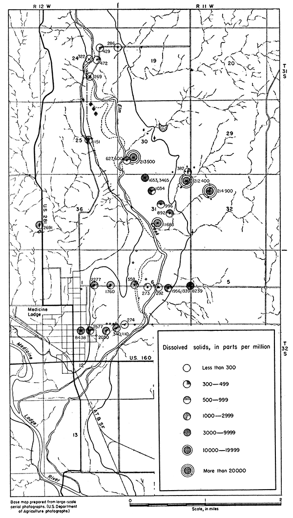
The analyses given in Table 3 indicate that the dissolved solids in water from wells and test holes ranged from 273 parts per million at test hole 31 to 11,683 parts per million at test hole 20. Dissolved solids in the oil-field brine ranged from 212,400 to 214,900 parts per million. The variation and range in dissolved solids contained in ground waters in this area is shown on Figure 3.
Figure 3--Map showing dissolved solids contained in ground water in Elm Creek Valley.
The hardness of water, which is the property that generally receives the most attention, is most commonly recognized by its effects when soap is used with the water in washing. Calcium and magnesium cause virtually all the hardness of ordinary waters. These constituents together with the carbonate and sulfate radicals form the greater part of the scale in steam boilers and in other vessels in which water is heated or evaporated.
In addition to the total hardness, the table of analyses shows the carbonate hardness and the noncarbonate hardness. The carbonate hardness is that due to the presence of calcium and magnesium bicarbonates. It is almost completely removed by boiling. In some reports this type of hardness is called temporary hardness. The noncarbonate hardness is generally due to the presence of sulfates or chlorides of calcium and magnesium; it cannot be removed by boiling and has sometimes been called permanent hardness. With reference to use with soaps, there is no difference between the carbonate and noncarbonate hardness. In general, the noncarbonate hardness forms harder scale in steam boilers.
Water having a hardness of less than 50 parts per million is generally rated as soft, and its treatment for the removal of hardness under ordinary circumstances is not necessary. Hardness between 50 and 150 parts per million does not seriously interfere with the use of water for most purposes, but it does slightly increase the consumption of soap, and its removal by a softening process is profitable for laundries or other industries using large quantities of soap. Waters in the upper part of this range of hardness will cause considerable scale on steam boilers. Hardness above 150 parts per million can be noticed by anyone and if the hardness is 200 or 300 parts per million, it is common practice to provide a municipal water softening plant. Where municipal water supplies are softened, an attempt is generally made to reduce the hardness to about 80 parts per million. The additional improvement from further softening of a whole public supply is not deemed worth the increase in cost.
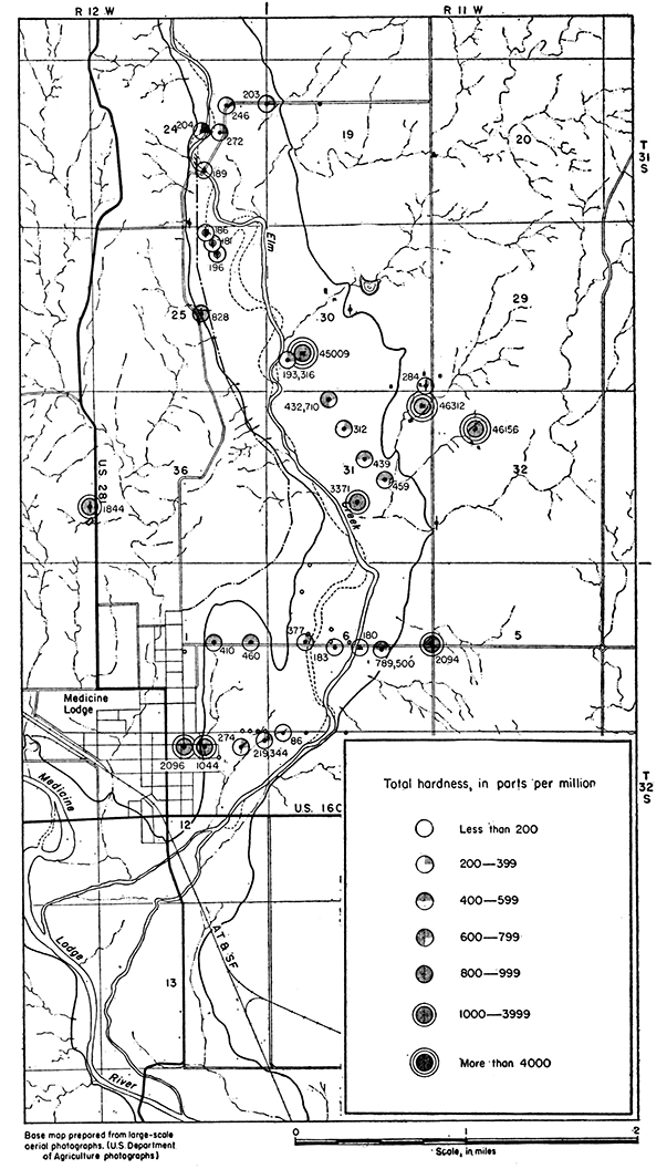
As shown by the analyses given in Table 3 and on Figure 4 water from wells near Elm Creek is not as hard as water in the alluvium near the valley edge or in the Cedar Hills sandstone.
Figure 4--Map showing total hardness of water in Elm Creek Valley.
Next to hardness, iron is the constituent of natural waters that in general receives the most attention. The quantity of iron in ground waters may differ greatly from place to place, even though the waters are derived from the same formation. If a water contains much more than 0.1 part per million of iron, the excess may be precipitated as a reddish sediment. Iron, which may be present in sufficient quantity to give a disagreeable taste and to stain cooking utensils, may be removed from most waters by simple aeration and filtration, but a few waters require the addition of lime or some other substance.
The content of iron was not determined for many of the samples of water collected because the samples contained particles of red, iron-bearing silt and shale. Samples from test holes were pumped by air lift, and were collected after the water had become reasonably clear. However, a pumping period of several days would have been required to obtain a completely clear sample. Furthermore, it was concluded that the air-lift method of pumping might have caused the precipitation of iron before the samples were collected. The iron content of water samples not collected by air-lift pumping is given in Table 4.
Table 4--Iron contained in water from Elm Creek Valley (Analyses by H, A. Stoltenberg)
| No. on plate 1 |
Iron (Fe) (parts per million) |
No. on plate 1 |
Iron (Fe) (parts per million) |
|---|---|---|---|
| 7 | 0.84 | A | 46. |
| 13 | 1.6 | B | 43. |
| 21 | 8.4 | C | 1.6 |
| 29 | .42 |
Although determinable quantities of fluoride are not so common as fairly large quantities of the other constituents of natural water, it is desirable to know the amount of fluoride present in water that is likely to be used by children. Fluoride in waters has been shown to be associated with the dental defect known as mottled enamel, which may appear on the teeth of children who, during the period of formation of the permanent teeth, drink water containing fluoride. It has been stated that waters containing one part per million or more of fluoride are likely to produce mottled enamel, although the effect of one part per million is not usually very serious. If water contains as much as four parts per million of fluoride, 90 percent of the children drinking the water are likely to have mottled enamel, and 35 percent or more of the cases will be classified as moderate or worse.
The analyses given in Table 3 indicate that ground water in this section of Elm Creek Valley is low in fluoride content. Two of the waters analyzed contained slightly more than 1 part per million of fluoride.
Sulfate in ground water is derived in large quantities from gypsum and from deposits of sodium sulfate. It is also formed by the oxidation of sulfides of iron and is therefore present in considerable quantities in waters from mines and from many beds of shale. Sulfate in waters that contain much calcium and magnesium causes the formation of hard scale in steam boilers and may increase the cost of softening the water.
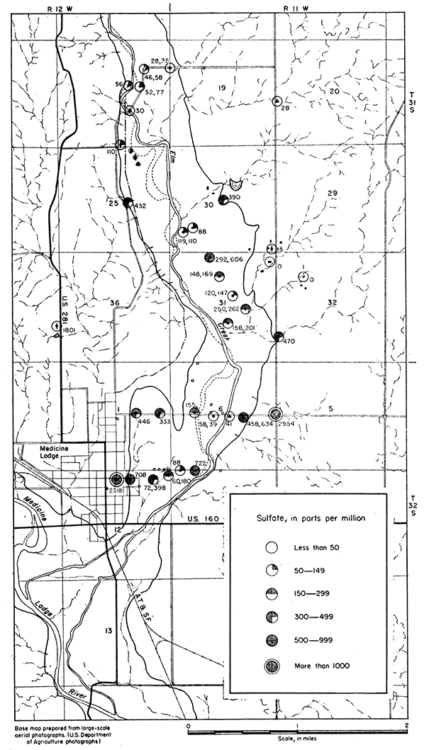
The sulfate content of the alkali water of the Cedar Hills sandstone is as high as 2,954 parts per million at test hole 27. The quantity of sulfate contained in water samples collected from wells and test holes in this area is shown on Figure 5. It is noteworthy that the samples of oil-field brine contained little or no sulfate.
Figure 5--Map showing sulfate contained in ground water in Elm Creek Valley.
Chlorine combined as chlorides is widely distributed in nature; it is an abundant constituent of sea water and oilfield brines and is dissolved in small quantities from many rock materials. Chloride has little effect on the suitability of water for ordinary use, unless there is enough present to impart a salty taste and render the water unpalatable. Waters high in chloride may be corrosive if used in steam boilers. Chlorides of calcium and magnesium contribute to the hardness of a water in a manner similar to the sulfates and carbonates of these elements. The removal of chloride from water supplies is difficult and expensive.
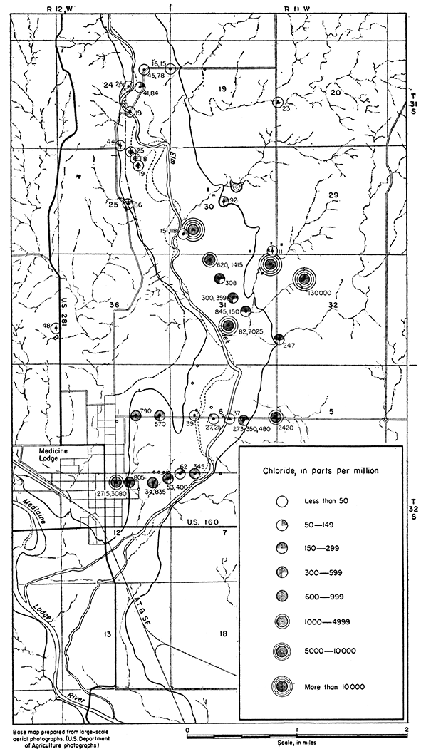
The range in chloride content of ground water in this area is shown on Figure 6. Attention is called to the extremely high chloride content of the oil-field brines.
Figure 6--Map showing chloride contained in ground water in Elm Creek Valley.
Variation in the chemical character of ground water in this area is closely related to stratigraphy, and the several geologic units discussed above contain waters widely different chemically.
The Cedar Hills sandstone contains much gypsum, iron, and other soluble minerals which are dissolved by water percolating through the formation. In general, water contained in the Cedar Hills is very hard and most of the hardness is noncarbonate or "permanent." The hardness of samples of water collected from this formation ranged from 344 parts per million at test hole 44 to 2,096 parts per million at test hole 47. The noncarbonate hardness ranged from 157 to 1,977 parts per million in these samples. Locally, as at test hole 27, water in the Cedar Hills contains chloride in sufficient quantity to impart a very salty taste.
The chemical character of ground water in the Cedar Hills sandstone is shown by analyses given in Table 3, and is shown graphically in Figures 3, 4, 5, 6, and 7.
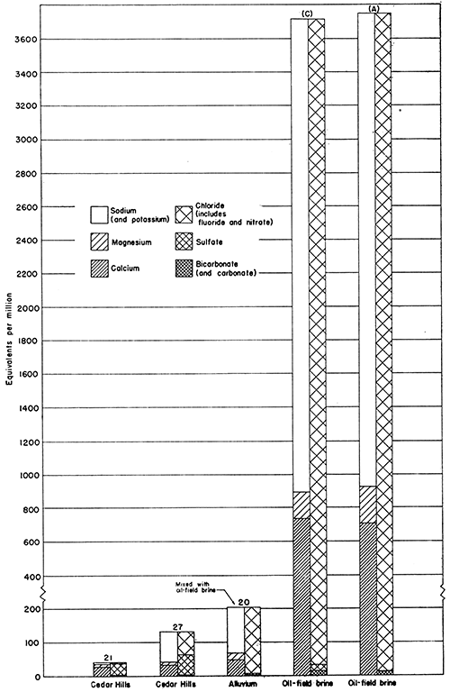
Figure 7--Graphs of analyses of oil-field brine and water from Cedar Hills sandstone. Note difference in scales used in Figures 7 and 8.
The Gerlane formation is neither extensive nor water bearing throughout its limited extent in this area. However, samples collected from the Gerlane indicate that in small areas it yields small quantities of water of better quality than is obtainable from the other formations. Analyses show that the total hardness of the water in the Gerlane ranges from 200 to 300 parts per million, and that most of the hardness is carbonate hardness. Minor quantities of chloride and other mineral constituents are contained in the water from the Gerlane formation. The chemical character of water from the Gerlane is shown by analyses in Table 3 and graphically in Figure 8.
Figure 8--Graphs of analyses of waters from Elm Creek, alluvium, and Gerlane formation.
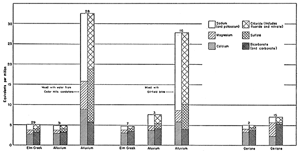
The chemical character of ground water in the alluvium of Elm Creek Valley varies greatly and is affected by water from the Cedar Hills sandstone and contamination by oil-field brine. Dissolved solids in water samples collected from the alluvium ranged from 273 parts per million at test hole 31 to 11,680 parts per million at test hole 20. In general, water of better quality is obtainable from the alluvium near the channel of Elm Creek than from the alluvium near the valley edge. Much of the ground water east of Elm Creek in sec. 31, T. 31 S., R. 11 W. seems to be contaminated by oil-field brine. In this part of the area the chloride content is as high as 7,000 parts per million. The content of sulfate in ground water in the alluvium is greatest near the valley edges, being 708 parts per million at test hole 46. The water supply for the City of Medicine Lodge is derived from the alluvium beneath and near the channel of Elm Creek.
The chemical character of ground water contained in the alluvium in this area is shown by analyses given in Table 3, and graphically on Figure 8.
The brine associated with petroleum deposits commonly contains several times as much dissolved mineral matter as ordinary sea water. Dissolved solids in samples of oil-field water from the Whelan pool ranged from 212,400 to 214,900 parts per million (Table 3), quantities near the maximum reported from Kansas oil fields (Schoewe, 1943, pp. 52-59).
Samples of water were collected from three separator-tank batteries at locations shown on Plate 1. The three samples were similar chemically and probably are representative of all the brine produced in the Whelan pool, The dominant salts contained in the brine are sodium chloride and calcium chloride. The absence of sulfate and the very small carbonate and bicarbonate content are noteworthy. The chemical composition of the brine is shown graphically in Figure 7. Comparison of graphs in Figures 7 and 8, with recognition of differences in scales, serves to illustrate the highly mineralized character of the brine.
As noted above, ground water in the alluvium along Elm Creek is derived from rainfall on the alluvium and from percolation from rocks at the valley edge toward the creek (Pl. 1). In addition to these natural sources, water derived from the oil-field brine disposal system in the Whelan oil pool is added to the ground-water in the alluvium.
The quantity of water which percolates from the Cedar Hills sandstone into the alluvium probably is not as large as the quantity derived from precipitation on the area underlain by alluvium. However, analyses of water from test holes show that sufficient percolation occurs that the water in the alluvium near the valley sides is similar chemically to the water contained in the Cedar Hills sandstone. The intrusion of mineralized water as shown by the analyses is indicated on Figures 5 and 8. Comparison of analyses 27, 28, and 29 show the effect of progressive dilution of water from the Cedar Hills by the water in the alluvium.
In general, intrusion of water from the Cedar Hills sandstone is most apparent in the lower parts of the alluvium and the more dilute mixtures occur in the upper part. The water in the gypsiferous Cedar Hills may be characterized as a calcium sulfate water and the concentration of sulfate in water samples collected from the alluvium is indicative of the extent of intrusion (Fig. 5). Other salts in addition to gypsum occur in parts of the Cedar Hills section. This occurrence is shown by analyses of water collected from test hole 47, in which the content of chloride is high (3,080 parts per million), in addition to 2,318 parts per million of sulfate. Water in the alluvium at test hole 46 contained 805 parts per million of chloride and 708 parts per million of sulfate, indicating mixing of water from the Cedar Hills sandstone with less highly mineralized water in the alluvium.
In the discussion above it has been pointed out that ground water moves southwestward from the Whelan oil pool toward Elm Creek and that any water seeping downward from the brine-disposal ponds ultimately moves in the same direction. Precipitated salts which had the characteristic taste of sodium chloride were observed occurring as a thin crust on the surface of the alluvium near test hole 20. The small ravine which drains the area near disposal pond (A) deploys over the surface of the alluvium at this place, and salt carried in solution by flood waters from the hillside is precipitated on the flat valley floor. Subsequent rains dissolve the precipitated salt and the solution seeps downward to the water table, increasing the mineral content of the ground water.
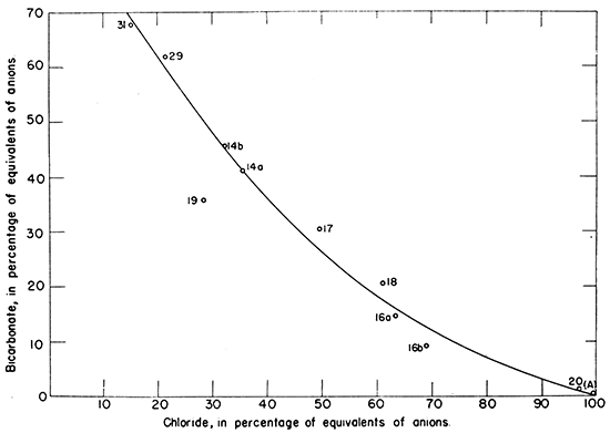
The graph in Figure 7 indicates that the principal mineral contained in the oil-field brine is sodium chloride and that the dominant anion is chloride. Indication of salt-water intrusion is shown on Figure 6. Comparison of analyses of water from test hole 4, near Elm Creek north of the oil field, and from the separator tanks shows the great chemical difference between the uncontaminated ground water and the brine. Comparison of analyses of water from test holes 31, 14, 16, 17, 18, 19, and 20 with the analysis of brine from pond (A) shows the extent of salt-water intrusion from the oil pool. The ratio of chloride to bicarbonate in these analyses is shown on Figure 9.
Figure 9--Graph showing the ratio of chloride to bicarbonate in ground-water samples from Elm Creek Valley.
The content of chloride was found to be larger in the lower part of the alluvium than in the upper part at most of the test holes where more than one sample was collected; exceptions were found at test holes 14 and 19, however. At test hole 20 the increase in chloride with depth is noteworthy. This stratification of waters of different quality also occurs at test holes 28 and 45 where highly mineralized water from the Cedar Hills sandstone has percolated into the alluvium.
The principal object of this investigation was to determine the quality of ground water in Elm Creek Valley and no special study was made of the quantity of water available for use. However, study of materials penetrated by the test drill together with records of the Medicine Lodge city water supply lead to the conclusion that a quantity of water of the order of 1,000,000 gallons a day may be available from wells properly constructed and located in those parts of the valley where the alluvium is thickest and most permeable, as near test hole 31. The Gerlane formation is thin and limited in extent, and would yield only small quantities of water in this area. The Cedar Hills sandstone is composed of fine-grained materials and is not sufficiently permeable to yield much water to wells.
The chemical quality of the ground water in Elm Creek Valley is variable and closely related to the stratigraphy, Analyses show that water from the Cedar Hills sandstone is very hard and in many places too highly mineralized for domestic use. Water from the Gerlane formation appears to be good in this area. In the alluvium ground water of best quality is available near the channel of Elm Creek, and water of poorest quality is found near the valley sides and down gradient from the Whelan oil pool. In most test holes in the alluvium water of best quality was found near the surface and water of poorer quality was found at greater depths.
Water high in mineral content enters the alluvium by percolation from the Cedar Hills sandstone and by seepage and surface flow from the oil-field brine disposal system in the Whelan pool. The quantity of ground water entering the alluvium from the Cedar Hills is sufficient to affect the quality of the water in the alluvium near the valley sides. It is estimated that about 21,000 gallons of brine is produced from the Whelan pool daily. Considering the slope of the water table, pattern of surface drainage, physical character of the alluvium, and analyses of water collected from the alluvium, it is believed that most of the oil-field brine enters the alluvium and contaminates the ground water. Salt-water intrusion is evident along the east side of Elm Creek southwest of the Whelan pool, especially in sec. 31, T. 31 S., R. 11 W. The quality of the water at creek station 29 and at test hole 31 indicates that either the contamination by the brine has not yet reached those places or that sufficient dilution has occurred so that contamination is not noticeable. If the development of a water supply from wells in the alluvium southwest of the oil field were planned, however, it would seem advisable that a well be constructed and pumped for a few months at a rate somewhat higher than that necessary to produce the quantity of water needed. A test of this kind would facilitate determination of the ultimate effect of the brine contamination of the ultimate effect of the brine contamination on the quality of the water at the place of development.
On the following pages are listed the logs of 25 test holes drilled by the State Geological Survey and 11 test holes drilled by the Layne-Western Company for the City of Medicine Lodge. Samples from test holes drilled by the Geological Survey were studied by C.K. Bayne.
| 1. Sample log of test hole in the SE NW sec. 19, T. 31 S., R. 11 W.; drilled by State Geological Survey, September, 1945. Surface altitude, 1,566,9 feet. | Thickness, feet |
Depth, feet |
||
|---|---|---|---|---|
| Road material and silt, tan | 3 | 3 | ||
| Quaternary | ||||
| Gerlane formation | ||||
| Gravel, coarse to fine, sand, coarse to fine, and silt, brown to tan | 5 | 8 | ||
| Silt, brown to tan | 6 | 14 | ||
| Gravel, coarse to fine, and sand, coarse to fine; contains silt, gray to tan | 6 | 20 | ||
| Gravel, medium to fine, and sand, coarse to fine; contains silt, gray and tan | 30 | 50 | ||
| Permian--Leonardian | ||||
| Cedar Hills sandstone | ||||
| Siltstone and shale, red | 2 | 52 | ||
| 2. Sample log of test hole at the NE cor. sec. 24, T. 31 S., R. 12 W., drilled by State Geological Survey, September, 1945. Surface altitude, 1,546.6 feet. | Thickness, feet |
Depth, feet |
||
|---|---|---|---|---|
| Quaternary--Recent | ||||
| Alluvium | ||||
| Sand, coarse to fine, and silt, gray | 2 | 2 | ||
| Silt, tan to gray | 5 | 7 | ||
| Gravel, coarse to fine, sand, coarse to fine, and silt, tan to gray | 13 | 20 | ||
| Gravel, coarse to fine, and sand, coarse to fine; contains some very coarse gravel | 5.5 | 25.5 | ||
| Permian--Leonardian | ||||
| Cedar Hills sandstone | ||||
| Siltstone and shale, red | 1.5 | 27 | ||
| 3. Sample log of test hole in the NE SW NE sec. 24, T. 31 S., R. 12 W.; drilled by State Geological. Survey, September, 1945. Surface altitude, 1,545,6 feet. | Thickness, feet |
Depth, feet |
||
|---|---|---|---|---|
| Road material | 4 | 4 | ||
| Quaternary--Recent | ||||
| Alluvium | ||||
| Gravel, medium to fine, and sand, coarse to fine; contains some silt, dark gray | 6 | 10 | ||
| Gravel, coarse to fine, and sand, coarse to fine | 10 | 20 | ||
| Sand, coarse to fine, and gravel, medium to fine | 17.5 | 37.5 | ||
| Permian--Leonardian | ||||
| Cedar Hills sandstone | ||||
| Siltstone and shale, red brown and mottled gray, and sandstone, very fine, red and white | 2.5 | 40 | ||
| 4. Sample log of test hole in the SW SW NE sec. 24, T. 31 S., R. 11 W., drilled by State Geological Survey, September, 1945, Surface altitude, 1,542.4 feet. | Thickness, feet |
Depth, feet |
||
|---|---|---|---|---|
| Quaternary--Recent | ||||
| Alluvium | ||||
| Sand, coarse to fine, silt, gray, and gravel, fine | 3 | 3 | ||
| Gravel, coarse to fine, and sand, coarse to fine | 7 | 10 | ||
| Gravel, medium to fine, sand, coarse to fine, and silt, tan | 10 | 20 | ||
| Gravel, fine, and sand, coarse to fine | 8 | 28 | ||
| Permian--Leonardian | ||||
| Cedar Hills sandstone | ||||
| Siltstone, red and mottled white | 2 | 30 | ||
| 5. Sample log of test hole in the SE NW sec. 24, T, 31 S., R. 12 W.; drilled by State Geological Survey, September, 1945. Surface altitude, 1,540.9 feet. | Thickness, feet |
Depth, feet |
||
|---|---|---|---|---|
| Quaternary--Recent | ||||
| Alluvium | ||||
| Sand, coarse to fine, gravel, medium to fine, and silt, gray | 2 | 2 | ||
| Sand, coarse to fine, and gravel, medium to fine | 8 | 10 | ||
| Sand, coarse to fine, and gravel, medium to fine | 4.5 | 14.5 | ||
| Permian--Leonardian | ||||
| Cedar Hills sandstone | ||||
| Siltstone and shale, red brown, mottled light blue gray | 1.5 | 16 | ||
| 14. Sample log of test hole in the SW SW sec. 30, T. 31 S., R. 11 W,; drilled by State Geological Survey, September, 1945. Surface altitude, 1,515.4 feet. | Thickness, feet |
Depth, feet |
||
|---|---|---|---|---|
| Quaternary--Recent | ||||
| Alluvium | ||||
| Silt, tan, and sand, coarse to fine | 5 | 5 | ||
| Gravel, coarse to fine, and sand, coarse to fine | 17 | 22 | ||
| Silt, gray; contains sand, coarse to fine | 7 | 29 | ||
| Gravel, medium to fine, and sand, coarse to fine; contains silt, gray | 6 | 35 | ||
| Permian--Leonardian | ||||
| Cedar Hills sandstone | ||||
| Siltstone, red, interbedded with sandstone, red | 2 | 37 | ||
| 16. Sample log of test hole in the NE NW sec. 31, T. 31 S., R. 11 W.; drilled by State Geological Survey, September, 1945. Surface altitude, 1,511,3 feet. | Thickness, feet |
Depth, feet |
||
|---|---|---|---|---|
| Soil, sandy, gray | 2 | 2 | ||
| Quaternary--Recent | ||||
| Alluvium | ||||
| Silt, light brown, and sand, coarse to fine | 3 | 5 | ||
| Silt, gray; contains gravel, medium to fine, and sand, coarse to fine | 2 | 7 | ||
| Gravel, medium to fine, and sand, coarse to fine | 14 | 21 | ||
| Silt and clay, gray; contains sand, coarse to fine | 13 | 34 | ||
| Gravel, coarse to fine, and sand, coarse to fine | 1 | 35 | ||
| Permian--Leonardian | ||||
| Cedar Hills sandstone | ||||
| Siltstone and shale, red, mottled light gray | 6 | 41 | ||
| Siltstone, red, sandy | 2 | 43 | ||
| 17. Sample log of test hole in the NE NW sec. 31, T. 31 S., R. 11 W.; drilled by State Geological Survey, September, 1945. Surface altitude, 1,509.4 feet. | Thickness, feet |
Depth, feet |
||
|---|---|---|---|---|
| Quaternary--Recent | ||||
| Alluvium | ||||
| Silt, tan, and sand, medium to fine | 6 | 6 | ||
| Gravel, coarse to fine, and sand, coarse to fine | 9 | 15 | ||
| Silt, gray; contains much sand, medium to fine | 15 | 30 | ||
| Silt, dark gray | 7 | 37 | ||
| Silt, dark gray; contains some gravel, fine, and sand, coarse to fine | 10 | 47 | ||
| Permian--Leonardian | ||||
| Cedar Hills sandstone | ||||
| Siltstone and shale, red brown, and sandstone, red | 3 | 50 | ||
| 18. Sample log of test hole in the SW NE sec. 31, T. 31 S., R. 11 W.; drilled by State Geological Survey, September, 1945, Surface altitude, 1,505.4 feet. | Thickness, feet |
Depth, feet |
||
|---|---|---|---|---|
| Quaternary--Recent | ||||
| Alluvium | ||||
| Sand, coarse to fine, and silt, brown | 5 | 5 | ||
| Gravel, medium to fine, and sand, coarse to fine | 5 | 10 | ||
| Gravel and sand, coarse.to fine; silty, brown | 43 | 53 | ||
| Silt, tan; contains sand, fine | 5 | 58 | ||
| Gravel and sand, coarse to fine | 10 | 68 | ||
| Permian--Leonardian | ||||
| Cedar Hills sandstone | ||||
| Siltstone and shale, red and brown | 2 | 70 | ||
| 19. Sample log of test hole in the SE NE sec. 31, T. 31 S., R. 11 W.; drilled by State Geological Survey, September, 1945, Surface altitude, 1,503,3 feet. | Thickness, feet |
Depth, feet |
||
|---|---|---|---|---|
| Quaternary--Recent | ||||
| Alluvium | ||||
| Silt, tan to brown; contains much sand, fine | 5 | 5 | ||
| Silt, gray; contains much gravel, fine, and sand, coarse to fine | 2 | 7 | ||
| Gravel and sand, coarse to fine; contains silt, gray. Partly cemented by calcium carbonate at base | 26 | 33 | ||
| Permian--Leonardian | ||||
| Cedar Hills sandstone | ||||
| Siltstone, red brown, and sandstone, very fine, red brown | 1 | 34 | ||
| 20. Sample log of test hole in the NW SE sec. 31, T. 31 S., R. 11 W., drilled by State Geological Survey, September, 1945. Surface altitude, 1,500.4 feet. | Thickness, feet |
Depth, feet |
||
|---|---|---|---|---|
| Quaternary--Recent | ||||
| Alluvium | ||||
| Sand, coarse to fine | 4 | 4 | ||
| Gravel and sand, coarse to fine; contains some silt, dark gray | 16 | 20 | ||
| Gravel, medium to fine, and sand, coarse to fine | 10 | 30 | ||
| Gravel and sand, coarse to fine | 13.5 | 43.5 | ||
| Permian--Leonardian | ||||
| Cedar Hills sandstone | ||||
| Siltstone and shale, red brown, and sandstone, very fine, red brown | 1.5 | 45 | ||
| 23. Driller's log of test hole in the NE cor, NW NW sec. 6, T. 32 S., R. 11 W.; drilled by the Layne-Western Company for the City of Medicine Lodge, April, 1944. | Thickness, feet |
Depth, feet |
||
|---|---|---|---|---|
| Soil | 1 | 1 | ||
| Quaternary--Recent | ||||
| Alluvium | ||||
| Sand, coarse to fine | 8 | 9 | ||
| Clay | 1 | 10 | ||
| Sand and gravel | 8 | 18 | ||
| Permian--Leonardian | ||||
| Cedar Hills sandstone | ||||
| Sandstone, red | 1 | 19 | ||
| 24. Driller's log of test hole in the SE NW NW sec. 6, T. 32 S., R. 11 W.; drilled by the Layne-Western Company for the City of Medicine Lodge, April, 1944. | Thickness, feet |
Depth, feet |
||
|---|---|---|---|---|
| Soil | 1 | 1 | ||
| Quaternary--Recent | ||||
| Alluvium | ||||
| Sand, fine | 2 | 3 | ||
| Sand and gravel | 14 | 17 | ||
| Permian--Leonardian | ||||
| Cedar Hills sandstone | ||||
| Sandstone, red | 1 | 18 | ||
| 25. Driller's log of test hole in the Cen. SE NW sec. 6, T. 32 S., R. 11 W.; drilled by the Layne-Western Company for the City of Medicine Lodge, April, 1944. | Thickness, feet |
Depth, feet |
||
|---|---|---|---|---|
| Soil | 1 | 1 | ||
| Quaternary--Recent | ||||
| Alluvium | ||||
| Sand, fine | 3 | 4 | ||
| Sand and gravel | 6 | 10 | ||
| Sand, clay streaks | 5 | 15 | ||
| Permian--Leonardian | ||||
| Cedar Hills sandstone | ||||
| Shale, red | 3 | 18 | ||
| 26. Driller's log of test hole in the SE SW NW sec. 6, T. 32 S., R. 11 W.; drilled by the Layne-Western Company for the City of Medicine Lodge, April, 1944. | Thickness, feet |
Depth, feet |
||
|---|---|---|---|---|
| Soil | 1 | 1 | ||
| Quaternary--Recent | ||||
| Alluvium | ||||
| Sand, coarse to fine | 8 | 9 | ||
| Clay | 1 | 10 | ||
| Sand and gravel; contains clay balls | 10 | 20 | ||
| Permian--Leonardian | ||||
| Cedar Hills sandstone | ||||
| Sandstone, red | 1 | 21 | ||
| 27. Sample log of test hole in the SE cor. NE sec. 6, T. 32 S., R. 11 W.; drilled by State Geological Survey, August, 1945, Surface altitude, 1,505,5 feet. | Thickness, feet |
Depth, feet |
||
|---|---|---|---|---|
| Road fill | 1 | 1 | ||
| Permian--Leonardian | ||||
| Cedar Hills sandstone | ||||
| Siltstone, red brown, and sandstone, fine, red brown | 17 | 18 | ||
| Sandstone, medium to very fine; contains much gypsum | 1.5 | 19.5 | ||
| Siltstone, red brown, mottled light gray; contains some gypsum and sandstone, very fine, red brown; sandstone increases downward | 60.5 | 80 | ||
| 28. Sample log of test hole in the NE NW SE sec. 6, T. 32 S., R. 11 W.; drilled by State Geological Survey, August, 1945, Surface altitude, 1,487.9 feet. | Thickness, feet |
Depth, feet |
||
|---|---|---|---|---|
| Quaternary--Recent | ||||
| Alluvium | ||||
| Silt, red, and sand, fine to medium | 2 | 2 | ||
| Sand, coarse to fine, and gravel, coarse to fine; contains clay balls and shells of mollusks | 44 | 46 | ||
| Silt, buff to dark gray | 10 | 56 | ||
| Silt, brown to buff; contains some carbonaceous material | 3 | 59 | ||
| Sand, coarse to fine, and gravel, very coarse to fine | 6 | 65 | ||
| Permian--Leonardian | ||||
| Cedar Hills sandstone | ||||
| Siltstone and shale, red, interbedded with sandstone, fine, red | 3 | 68 | ||
| 30. Driller's log of test hole in the SE cor. NW sec. 6, T. 32 S., R. 11 W.; drilled by the Layne-Western Company for the City of Medicine Lodge, April, 1944. | Thickness, feet |
Depth, feet |
||
|---|---|---|---|---|
| Quaternary--Recent | ||||
| Alluvium | ||||
| Sand, fine, silty | 5 | 5 | ||
| Sand, coarse to fine, and gravel; contains clay balls | 12 | 17 | ||
| Clay, blue, sandy | 2 | 19 | ||
| Sand and gravel | 4 | 23 | ||
| Sand, very fine, silty | 7 | 30 | ||
| Sand, coarse to medium, clay streaks | 12 | 42 | ||
| Clay, red | 3 | 45 | ||
| Clay, interbedded with sand, fine, silty | 10 | 55 | ||
| Sand, medium to fine, gray | 3 | 58 | ||
| Permian--Leonardian | ||||
| Cedar Hills sandstone | ||||
| Sandstone, red | 1 | 59 | ||
| 31. Sample log of test hole in the NE SW sec. 6, T. 32 S., R. 11 W,; drilled by State Geological Survey, August, 1945. Surface altitude, 1,484.5 feet. | Thickness, feet |
Depth, feet |
||
|---|---|---|---|---|
| Road material | 2 | 2 | ||
| Quaternary--Recent | ||||
| Alluvium | ||||
| Gravel and sand, coarse to fine | 18 | 20 | ||
| Gravel and sand, coarse to fine; contains some silt, tan | 16 | 36 | ||
| Silt, gray, and sand, coarse to fine | 4 | 40 | ||
| Gravel, medium to fine, and sand coarse to fine; contains some silt, gray to tan | 10 | 50 | ||
| Silt, gray, gravel, medium to fine, and sand, coarse to fine | 5 | 55 | ||
| Gravel and sand, coarse to fine | 11 | 66 | ||
| Permian--Leonardian | ||||
| Cedar Hills sandstone | ||||
| Siltstone and shale, red brown, and sandstone, fine, mottled red and white | 4 | 70 | ||
| 32. Driller's log of test hole in the SW SE NW sec. 6, T. 32 S., R. 11 W.; drilled by the Layne-Western Company for the City of Medicine Lodge, April, 1944. | Thickness, feet |
Depth, feet |
||
|---|---|---|---|---|
| Soil | 1 | 1 | ||
| Quaternary--Recent | ||||
| Alluvium | ||||
| Sand, fine | 3 | 4 | ||
| Sand, coarse, and gravel | 19 | 23 | ||
| Sand, coarse to medium | 5 | 28 | ||
| Sand, coarse | 2 | 30 | ||
| Sand, coarse to fine | 10 | 40 | ||
| Sand and gravel | 20 | 60 | ||
| Permian--Leonardian | ||||
| Cedar Hills sandstone | ||||
| Sandstone, red | 1 | 61 | ||
| 33. Sample log of test hole in the NW NE SW sec. 6, T. 32 S., R. 11 W.; drilled by State Geological Survey, August, 1945. Surface altitude, 1,483.4 feet. | Thickness, feet |
Depth, feet |
||
|---|---|---|---|---|
| Quaternary--Recent | ||||
| Alluvium | ||||
| Silt, red brown; contains sand, fine | 2 | 2 | ||
| Sand and gravel, coarse to fine; contains silt, red | 8 | 10 | ||
| Sand, coarse, and gravel, coarse to fine | 4 | 14 | ||
| Permian--Leonardian | ||||
| Cedar Hills sandstone | ||||
| Siltstone and shale, red, and sandstone, fine, red and white | 4 | 18 | ||
| 34. Sample log of test hole in the SE sec. 1, T. 32 S., R. 11 W.; drilled by State Geological Survey, August, 1945. Surface altitude, 1,479.7 feet. | Thickness, feet |
Depth, feet |
||
|---|---|---|---|---|
| Quaternary--Recent | ||||
| Alluvium | ||||
| Silt, red, contains some sand, fine | 5 | 5 | ||
| Silt, red brown; contains gravel and sand, coarse to fine | 15 | 20 | ||
| Gravel, medium to fine, sand, coarse to fine, and silt, red brown; silt increases downward | 10 | 30 | ||
| Silt and clay, gray | 8 | 38 | ||
| Silt and clay, tan to dark gray; contains sand, fine | 11 | 49 | ||
| Gravel and sand, coarse to fine; contains silt, tan to gray | 3 | 58 | ||
| Silt, blue gray | 6 | 55 | ||
| Permian--Leonardian | ||||
| Cedar Hills sandstone | ||||
| Siltstone and shale, red brown, and sandstone, fine, red | 2 | 60 | ||
| 35. Sample log of test hole in the SW NE sec. 1, T, 32 S., R. 12 W.; drilled by State Geological Survey, August, 1945, Surface altitude, 1,480.5 feet. | Thickness, feet |
Depth, feet |
||
|---|---|---|---|---|
| Quaternary--Recent | ||||
| Alluvium | ||||
| Silt, brown, and sand, coarse to fine | 2.5 | 2.5 | ||
| Silt, tan to red brown, gravel, medium to fine, and sand, coarse to fine | 4.5 | 7 | ||
| Gravel, fine to medium, and sand, coarse to fine; contains silt, red, brown | 2 | 9 | ||
| Silt, red brown; contains sand, coarse to fine | 11 | 20 | ||
| Silt, gray and tan; contains sand, medium to fine | 3 | 23 | ||
| Gravel, fine, and sand, coarse to fine; contains silt, gray and tan | 7 | 30 | ||
| Silt, gray and tan; contains sand, coarse to fine | 7 | 37 | ||
| Silt, gray and tan | 11 | 48 | ||
| Silt, dark gray to gray; contains sand, coarse to fine | 6 | 54 | ||
| Sand, coarse to fine, silt, gray, and gravel, fine to coarse | 5 | 59 | ||
| Permian--Leonardian | ||||
| Cedar Hills sandstone | ||||
| Sandstone, fine, red, and siltstone, red | 1 | 60 | ||
| 36. Sample log of test hole in the NW SE sec. 1, T. 32 S., R. 12 W.; drilled by State Geological Survey, August, 1945. Surface altitude, 1,527.1 feet. | Thickness, feet |
Depth, feet |
||
|---|---|---|---|---|
| Quaternary | ||||
| Gerlane formation | ||||
| Silt, tan, and sand, coarse; contains some gravel, medium to fine | 2 | 2 | ||
| Gravel, medium to fine, and silt, red brown; contains sand, fine | 6 | 8 | ||
| Silt, red brown; contains gravel and sand, coarse to fine | 10 | 18 | ||
| Silt, red brown; contains sand, fine | 11 | 29 | ||
| Sand, coarse to fine, and gravel, fine to medium | 11 | 40 | ||
| Gravel, coarse to fine, and sand, coarse; partly cemented by calcium sulfate | 17 | 57 | ||
| Silt, red brown; contains gravel, medium to fine, and sand, coarse to fine | 4 | 61 | ||
| Gravel and sand, coarse to fine; contains silt, tan | 19 | 80 | ||
| Gravel and sand, coarse to fine | 11 | 91 | ||
| Permian--Leonardian | ||||
| Cedar Hills sandstone | ||||
| Sandstone, very fine to fine, red brown, and siltstone red brown | 9 | 100 | ||
| Sandstone, very fine to fine, and siltstone, tan | 14 | 114 | ||
| Siltstone and shale, red brown; contains gypsum | 16 | 130 | ||
| 37. Sample log of test hole in the NE cor, NW sec. 7, T. 32 S., R. 11 W.; drilled by State Geological Survey, August, 1945, Surface altitude, 1,525.8 feet. | Thickness, feet |
Depth, feet |
||
|---|---|---|---|---|
| Quaternary | ||||
| Gerlane formation | ||||
| Gravel, very coarse to fine, and sand, coarse to fine; contains silt, tan | 2 | 2 | ||
| Gravel, medium to fine, and sand, coarse to fine | 8 | 10 | ||
| Gravel and sand, coarse to fine | 11 | 21 | ||
| Gravel, fine, and sand, coarse to fine; partly cemented by calcium carbonate | 19 | 40 | ||
| Gravel, medium to fine, and sand, coarse to fine | 5 | 45 | ||
| Permian--Leonardian | ||||
| Cedar Hills sandstone | ||||
| Siltstone and shale, red brown | 3 | 48 | ||
| 38. Sample log of test hole in the NE NW NW sec. 7, T. 32 S., R. 11 W.; drilled by State Geological Survey, August, 1945, Surface altitude, 1,473,0 feet. | Thickness, feet |
Depth, feet |
||
|---|---|---|---|---|
| Quaternary--Recent | ||||
| Alluvium | ||||
| Gravel, medium to fine, and sand, coarse; contains some silt, red brown | 1.5 | 1.5 | ||
| Sand and gravel, coarse to fine; contains clay balls and shells of mollusks at base | 13.5 | 15 | ||
| Silt and clay, red | 5 | 20 | ||
| Permian--Leonardian | ||||
| Cedar Hills sandstone | ||||
| Siltstone, red, and sandstone, fine-grained, mottled red and white; contains much gypsum | 18 | 38 | ||
| 39, Sample log of test hole in the NW NW sec. 7, T. 32 S., R. 11 W.; drilled by State Geological Survey, August, 1945. Surface altitude, 1,470.4 feet. | Thickness, feet |
Depth, feet |
||
|---|---|---|---|---|
| Quaternary--Recent | ||||
| Alluvium | ||||
| Sand, medium to coarse, and gravel, medium to fine; contains much silt, brown | 0.5 | 0.5 | ||
| Sand and gravel, coarse to fine; contains some silt, red | 0.5 | 1 | ||
| Sand, coarse to fine, and gravel, medium to fine; contains clay balls | 13 | 14 | ||
| Permian--Leonardian | ||||
| Cedar Hills sandstone | ||||
| Siltstone and shale, red, and sandstone, fine, mottled red and white | 10 | 24 | ||
| Siltstone, red, and sandstone, fine, mottled red and white; contains much granular gypsum and selenite | 16 | 40 | ||
| 40. Driller's log of test hole in the SE cor. sec. 1, T. 31 S., R. 12 W.; drilled by the Layne-Western Company for the City of Medicine Lodge, April, 1944. | Thickness, feet |
Depth, feet |
||
|---|---|---|---|---|
| Soil, sandy | 1 | 1 | ||
| Quaternary--Recent | ||||
| Alluvium | ||||
| Sand, fine, dirty | 4 | 5 | ||
| Sand, coarse, and gravel; contains some clay streaks | 13 | 18 | ||
| Sand, coarse | 3 | 21 | ||
| Sand, fine | 10 | 31 | ||
| Clay, soft, and sand, fine | 9 | 40 | ||
| Sand, fine | 3 | 43 | ||
| Sand, coarse to medium | 7 | 50 | ||
| Sand, coarse to fine, gravel; contains a few clay balls | 6 | 56 | ||
| Sand, coarse to medium | 4 | 60 | ||
| Sand and gravel; contains small boulders | 5 | 65 | ||
| Permian--Leonardian | ||||
| Cedar Hills sandstone | ||||
| Sandstone, red | 1 | 66 | ||
| 41. Driller's log of test hole in the SE SE SE sec. 1, T, 31 S., R. 12 W,; drilled by the Layne-Western Company for the City of Medicine Lodge, April, 1944. | Thickness, feet |
Depth, feet |
||
|---|---|---|---|---|
| Soil, sandy | 1 | 1 | ||
| Quaternary--Recent | ||||
| Alluvium | ||||
| Sand, dirty | 2 | 3 | ||
| Clay, blue | 3 | 6 | ||
| Sand, fine | 3 | 9 | ||
| Sand, coarse, and gravel | 6 | 15 | ||
| Sand; contains clay streaks | 3 | 18 | ||
| Sand, coarse; contains some gravel | 15 | 33 | ||
| Sand, fine; contains clay streaks | 3 | 36 | ||
| Clay | 1 | 37 | ||
| Sand, fine | 9 | 46 | ||
| Sand, coarse | 3 | 49 | ||
| Sand, fine | 10 | 59 | ||
| Sand and gravel; contains a few small boulders | 8 | 67 | ||
| Permian--Leonardian | ||||
| Cedar Hills sandstone | ||||
| Sandstone, red | 1 | 68 | ||
| 42. Driller's log of test hole in the SW SE SE sec. 1, T. 31 S., R. 12 W.; drilled by the Layne-Western Company for the City of Medicine Lodge, April, 1944. | Thickness, feet |
Depth, feet |
||
|---|---|---|---|---|
| Soil, sandy | 2 | 2 | ||
| Quaternary--Recent | ||||
| Alluvium | ||||
| Clay, blue | 4 | 6 | ||
| Sand, medium to fine | 7 | 13 | ||
| Sand, coarse, and gravel | 3 | 16 | ||
| Sand, fine | 5 | 21 | ||
| Sand, medium to coarse | 4 | 25 | ||
| Sand and gravel; contains clay streaks | 5 | 30 | ||
| Clay and sand, fine | 4 | 34 | ||
| Sand, medium to fine | 5 | 39 | ||
| Clay, red, soft; contains sand streaks | 14 | 53 | ||
| Sand, coarse to medium | 5 | 58 | ||
| Sand and gravel; contains some clay streaks | 7 | 65 | ||
| Sand and gravel; contains some boulders | 3 | 68 | ||
| Permian--Leonardian | ||||
| Cedar Hills sandstone | ||||
| Sandstone, red | 1 | 69 | ||
| 43. Driller's log of test hole in the SW SE SE sec. 1, T. 31 S., R. 12 W.; drilled by the Layne-Western Company for the City of Medicine Lodge, April, 1944. | Thickness, feet |
Depth, feet |
||
|---|---|---|---|---|
| Soil, sandy | 2 | 2 | ||
| Quaternary--Recent | ||||
| Alluvium | ||||
| Clay, blue | 4 | 6 | ||
| Sand, coarse to fine; contains some gravel and some clay balls | 12 | 18 | ||
| Sand, fine; contains some clay | 2 | 20 | ||
| Sand, coarse | 6 | 26 | ||
| Sand and gravel; contains a few clay streaks | 8 | 34 | ||
| Sand, medium to fine | 5 | 39 | ||
| Clay, soft streaks | 20 | 59 | ||
| Sand and gravel; contains a few boulders | 7 | 66 | ||
| 44. Sample log of test hole in NE NE sec. 12, T. 32 S., R. 12 W., drilled by State Geological Survey, August, 1945. Surface altitude, 1,469.5 feet. | Thickness, feet |
Depth, feet |
||
|---|---|---|---|---|
| Quaternary--Recent | ||||
| Alluvium | ||||
| Silt, dark brown, and sand, coarse to fine; contains some gravel, coarse to fine | 2.5 | 2.5 | ||
| Sand and gravel, coarse to fine | 6.5 | 9.0 | ||
| Sand, coarse to fine, and clay, gray to dark gray; contains sand, medium to fine | 11 | 20 | ||
| Clay, gray to red, and sand and gravel, coarse to fine | 10 | 30 | ||
| Silt, red; contains sand, fine | 16 | 46 | ||
| Sand, coarse to fine, and gravel, medium to fine; contains clay, red, and sand, fine | 6.5 | 52.5 | ||
| Permian--Leonardian | ||||
| Cedar Hills sandstone | ||||
| Sandstone, red, fine to medium | 3.5 | 56 | ||
| 45. Sample log of test hole in the NW NE NE sec. 12, T. 32 S., R. 11 W.; drilled by State Geological Survey, August, 1945, Surface altitude, 1,468.9 feet. | Thickness, feet |
Depth, feet |
||
|---|---|---|---|---|
| Quaternary--Recent | ||||
| Alluvium | ||||
| Silt, gray; contains sand, coarse to fine | 2.5 | 2.5 | ||
| Sand, coarse, and gravel, medium; partly cemented by calcium carbonate | 0.5 | 3.0 | ||
| Clay, black to red; contains sand, fine | 2.0 | 5.0 | ||
| Sand, coarse, and gravel, medium; contains clay, dark gray | 15 | 20 | ||
| Sand, coarse, and gravel, medium to fine; contains clay balls, red | 22 | 42 | ||
| Sand, coarse to fine, and gravel, medium to fine; contains some silt, red to gray | 22 | 64 | ||
| Permian--Leonardian | ||||
| Cedar Hills sandstone | ||||
| Sandstone, fine, mottled red and white | 6 | 70 | ||
| 46. Sample log of test hole in the Cen. NW NE sec. 12, T. 32 S., R. 12 W.; drilled by State Geological Survey, August, 1945. Surface altitude, 1,472.8 feet. | Thickness, feet |
Depth, feet |
||
|---|---|---|---|---|
| Quaternary--Recent | ||||
| Alluvium | ||||
| Sand, coarse to fine, and gravel, coarse to fine; contains silt, red | 2.0 | 2.0 | ||
| Sand, coarse to fine; contains some gravel, coarse to fine | 6.0 | 8.0 | ||
| Sand, coarse to fine, and gravel, medium to fine; contains clay, gray to black, and shells of mollusks | 12 | 20 | ||
| Gravel, coarse to fine, and sand, coarse to medium | 3 | 23 | ||
| Permian--Leonardian | ||||
| Cedar Hills sandstone | ||||
| Siltstone, red, and sandstone, fine, red | 4 | 27 | ||
| 47. Sample log of test hole in the NW NW sec. 12, T. 32 S., R. 12 W.; drilled by State Geological Survey, August, 1945. Surface altitude, 1,496.5 feet. | Thickness, feet |
Depth, feet |
||
|---|---|---|---|---|
| Quaternary | ||||
| Gerlane formation | ||||
| Gravel and sand, coarse to fine; contains silt, red | 4 | 4 | ||
| Sand, coarse to fine, and gravel, fine | 3 | 7 | ||
| Gravel, coarse to fine; contains some sand, coarse to medium | 8 | 15 | ||
| Gravel, coarse to fine, and sand, coarse to medium; contains clay balls, red | 10 | 25 | ||
| Permian--Leonardian | ||||
| Cedar Hills sandstone | ||||
| Siltstone and shale, red, interbedded with thin sandstone, fine, mottled red and white | 5 | 30 | ||
| Sandstone, fine, mottled red and white, and siltstone, red | 13 | 43 | ||
| Siltstone and shale, soft, red, and sandstone, fine, red; contains some gypsum | 9 | 52 | ||
| Sandstone, fine, mottled red and white, and shale, soft, red; contains much granular gypsum and selenite | 27.5 | 79.5 | ||
| Sandstone, fine, red, and siltstone, red; contains much gypsum | 20.5 | 100 | ||
| 48. Driller's log of test hole in the SW NW NW sec. 12, T. 32 S., R. 12 W.; drilled by the Layne-Western Company for the City of Medicine Lodge, April, 1944. | Thickness, feet |
Depth, feet |
||
|---|---|---|---|---|
| Soil, black | 1 | 1 | ||
| Quaternary--Recent | ||||
| Alluvium | ||||
| Sand, fine, dirty | 3 | 4 | ||
| Sand, gravel, and some clay | 9 | 13 | ||
| Sand, coarse to medium | 6 | 19 | ||
| Permian--Leonardian | ||||
| Cedar Hills sandstone | ||||
| Shale, red | 1 | 20 | ||
Clarke, F, W., and Washington, H. S., 1924, The composition of the earth's crust: U.S. Geol. Survey, Prof. Paper 127, pp. 1-117. [available online]
Jones, O, S., 1945, Disposition of oil field brines: Univ. of Kansas Press, pp. 1-192,
Knight, G. L., 1934, Gerlane formation (abstract): Geol. Soc. America, Proc 1933, p. 91.
Latta, B. F., 1946, Geology and ground-water resources of Kiowa County, Kansas: Kansas Geol. Survey, Bull. 65 (In press). [available online]
Norton, G. H., 1939, Permian redbeds of Kansas: Am. Assoc. Petroleum Geologists Bull., vol. 23, no, 12, pp. 1751-1815, figs, 1-24.
Schoewe, W. H., 1943, Kansas oil field brines and their magnesium content: Kansas Geol. Survey, Bull. 47, part 2, pp. 41-76. figs, 1-3. [available online]
Ver Wiebe, W. A., 1938, Oil and gas resources of western Kansas: Kansas Geol. Survey, Min. Resources Circ, 10, pp. 1-179.
Ver Wiebe, W. A., 1939, Exploration for oil and gas in western Kansas during 1938: Kansas Geol. Survey, Min. Resources Circ. 13, pp. 1-106.
Ver Wiebe, W. A., 1940, Exploration for oil and gas in western Kansas during 1939: Kansas Geol. Survey, Bull. 28, pp. 1-106, figs. 1-34.
Ver Wiebe, W. A., 1941, Exploration for oil and gas in western Kansas during 1940: Kansas Geol. Survey, Bull. 36, pp. 1-109, figs. 1-40, pl. 1.
Ver Wiebe, W. A., 1942, Exploration for oil and gas in western Kansas during 1941: Kansas Geol. Survey, Bull. 42, pp. 1-123, figs, 1-42.
Ver Wiebe, W. A., 1943, Exploration for oil and gas in western Kansas during 1942: Kansas Geol. Survey, Bull. 48, pp. 1-88, figs. 1-30.
Ver Wiebe, W. A., 1944, Exploration for oil and gas in western Kansas during 1943: Kansas Geol. Survey, Bull. 54, pp. 1-104, figs, 1-31.
Ver Wiebe, W. A., 1945, Exploration for oil and gas in western Kansas during 1944: Kansas Geol. Survey, Bull. 56, pp. 1-112, figs. 1-30.
Ver Wiebe, W. A., 1946, Exploration for oil and gas in western Kansas during 1945: Kansas Geol. Survey, Bull. 62, pp. 1-112, figs. 1-31.
Plate 1--Map of a portion of Elm Creek Valley showing geology and water table contours, 1945.
Kansas Geological Survey
Placed on web June 5, 2015; originally published Sept. 1946.
Comments to webadmin@kgs.ku.edu
The URL for this page is http://www.kgs.ku.edu/Publications/Bulletins/64_3/index.html