![]()
Prev Page—Geography || Next Page—Geophysical Survey
Geology
General Geologic Setting
The occurrence and genesis of the zinc-lead ores of the Mississippi Valley region (including the Tri-State district) have been discussed in detail in Special Paper 24 of the Geological Society of America (Bastin et al., 1939). This publication also gives a detailed bibliography of the previous literature relating to the geologic occurrence of lead-zinc ores in the Tri-State district. It will be necessary here, therefore, only to summarize such features of the geology as are of significance in making geophysical measurements and interpretations. The geology to be discussed will be essentially that of the northwestern portion of the district (northern Ottawa county, Oklahoma, and Cherokee county, Kansas) in which the geophysical work was done.
In the portion of the mining district studied, the thickness of Paleozoic rocks (Cambrian to Pennsylvanian) is stated to be about 1,700 to 1,800 feet (Weidman, 1932, p. 7). Below the Paleozoic is pre-Cambrian granite, stated to occur at a depth of 1,700-1,850 feet at Miami, Oklahoma; 1,772 feet at Carthage, Missouri; and 1,770 feet at Columbus, Kansas (Weidman, 1932, p. 6). Weidman (p. 6) reports that granite was found in a well at the Bird Dog mine at a depth of 1,245 feet. No other intrusive masses have been recorded in the Tri-State district, although many small intrusive bodies are found throughout the Mississippi Valley region (Tolman and Landes, Bastin et al., 1939, pp. 71-103).
Above the pre-Cambrian, but below the ore horizons, is 1,300 to 1,500 feet of pre-Mississippian sediments (Weidman, 1932, p. 6). This series of pre-Mississippian sediments is overlain unconformably by the thin Mississippian Chattanooga shale above which is an average of 300 to 400 feet of Mississippian chert and limestone belonging to the Meramec and Osage (Boone formation) series (Moore, Fowler, and Lyden, Bastin et al., 1939, pp. 2-4). Some ore is found in the Warsaw limestone (Meramec) , but the majority of the ore zones are confined to the Keokuk and Reed Springs limestones and cherts (Osage) averaging from 100 to 200 feet below the overlying Cherokee shale. The Warsaw and Keokuk in the Tri-State district have been carefully subdivided on the basis of minor lithologic variations (Moore, Fowler, and Lyden, Bastin et al., 1939, pp. 2-4). Most of the structural mapping is based on the structure as determined on one or more of the lithologic horizons within the Keokuk.
Unconformably overlying the Meramec series are as much as 80 feet of strata belonging to the Mayes, or Cartersville, formation of Chester age (Moore, Fowler, and Lyden, Bastin et al., 1939, p. 11). According to Weidman (1932, pp. 18-20), the Mayes is variable in thickness and lithology, but is everywhere present beneath the Cherokee in the Oklahoma-Kansas mining field. The thickness is said to vary from 10 to 60 feet. Although the lithology of the Mayes varies considerably, Weidman states (1932, p. 20) that the upper part of the formation is generally composed of sandstone or shale, whereas the lower 15 to 30 feet is limestone.
It has been customary in the Tri-State district to begin saving churn drill samples only after the first limestone is reached. The overlying shale is generally all listed as Cherokee. However, it must.be remembered that the lower portion of the shale section may be merely the upper shaly portion of the Mayes formation. Moreover, since the lithology of the Mayes varies considerably, structure contours drawn on top of the limestone represent neither the top of the Mississippian nor the top of any definite stratigraphic horizon within the Mississippian. Contours drawn on the limestone surface, therefore, do not necessarily represent either a structural or erosional surface, but merely a lithologic boundary. Fortunately, for geophysical interpretation, the position of this lithologic boundary is of greater importance than the position of stratigraphic boundaries.
The Pennsylvanian Cherokee shale (Des Moines) lies unconformably upon the Mississippian in the western part of the district. The Cherokee consists of dense clay and shale with several definite sandstone horizons. In common with the other sediments of the district, the Cherokee dips gently northwestward. The eastern boundary of the Cherokee overlap is, in the Tri-State district, somewhat west of the Missouri border (Weidman, 1932, pl. 1, and Pierce and Courtier, 1937, pl. 1). In the area studied, the Cherokee reaches a maximum thickness of about 200 feet.
Locally, deposits of "Tertiary" clay and coarse chert gravel overlie the Cherokee. Weidman states (1932, p. 27) that such deposits have a thickness of as much as 30 feet. This figure accords with field exposures and drill records examined by us. The driller's logs generally group these clays with the surficial soil mantle. It is therefore often impossible to determine from a driller's log whether the term "soil" or "clay" indicates "Tertiary" deposits or simply material derived from the weathering, in situ, of the underlying Paleozoic rocks. Where gravel is recorded, the material above and including the gravel is generally Tertiary. Often, however, the gravel and "clay" or "soil" are grouped together. Therefore, as a general rule, the actual thickness of the Tertiary cannot be ascertained nor can the presence of Tertiary sediments be established with certainty unless gravel is present.
The Mississippian and Pennsylvanian sediments in the Tri-State district have an average dip of 15 to 20 feet per mile to the northwest (Weidman, Bastin et al., 1939, p. 49). The most prominent structural feature, in the portion of the district geophysically studied, is the Miami trough—a series of disconnected structural lows, averaging about half a mile in width, trending northeastward from Commerce, Oklahoma to Lawton, Kansas, and having a maximum structural relief of something over 200 feet. It is believed that the trough has resulted from repeated shearing, solution, and slumping.
Ore bodies generally occur only in those parts of the district which have been subjected to pre-mineralization flexing, shearing, and brecciation (Fowler, Bastin, et al., 1939, pp. 53-60). Concerning structural control of ore deposition, Fowler says (Bastin et al., 1939, pp. 55-58):
All beds of the Boone formation are barren of mineralization except where deformation created structures favorable for ore reservoirs. … In the search for ore in the Tri-State district, the structural features of importance have been determined largely by contouring convenient strata and by mapping the shear zones in the underground workings. As minor flexing was of great importance in creating ore reservoirs, the contours were drawn at vertical intervals of five feet. They show that nearly all of the ore bodies in the district trend with the strike of the structure contours. … The main part of the Oklahoma-Kansas field is a roughly circular area in which the rocks were compressed and shortened in a general north-south direction and elongated in an east-west direction. This deformation relieved the stresses by flexing the strata and by forming northwesterly and northeasterly trending shear zones. Widespread shattering of marked intensity occurred contemporaneously. … Zones of intense deformation where the deformed and shattered strata moved from a few inches to several feet, instead of many feet, were particularly favorable ore reservoirs. Structural displacement of many feet generally lacked the intense shattering and opening of beds so essential in localizing these ore bodies. Fissures or shear zones are very numerous throughout the district and range from a few inches to several hundred feet in width and from a few feet to several miles in length. … The structural conditions most favorable for major ore reservoirs are wide, strong, and intensely shattered shear zones contiguous to deformed strata that have been opened along the bedding planes and stylolite partings.
Sink holes and caverns are found in the Mississippian limestone throughout the district, but there is believed to be no general correlation between the occurrence of caverns and of ore.
For the purposes of this paper, two types of ore bodies will be recognised—"runs" and "sheet ground." Sheet ground deposits are tabular deposits generally paralleling definite stratigraphic horizons and having horizontal dimensions large in comparison to the vertical dimensions. Run deposits are those having a large vertical and one large horizontal dimension and are generally believed to be related to shear zones. It is recognized that there may be all gradations between the two types of deposits. The ore bodies are, in general, highly irregular in outline and in sulphide content. Any ore horizon may, within a few feet horizontally or vertically, grade into barren ground.
The principal ore minerals are sphalerite (zinc sulphide, sp. grav., 3.9 to 4.1) and galena (lead sulphide, sp. grav., 7.4 to 7.6). Occasionally pyrite or marcasite (iron disulphide, sp. grav., 4.9 to 5.1) occurs in the ore. Iron disulphide is also commonly found in the, Cherokee shale—especially near its base. The occurrence of pyrite in the shale is generally not recorded in the driller's logs. The sulphide mineralization is generally accompanied by intense brecciation and chertification of the surrounding limestone and, occasionally, by dolomitization. The many other minerals reported from the district generally occur in only minor amounts in the northwestern portion of the mining field.
Concerning the relative occurrence of galena and sphalerite, Weidman (1932, pp. 76, 77) makes the following observations:
If the ratio of zinc to lead ore for the entire district be taken as 5.5: 1, the ratio for individual mines in the syncline (Miami Trough) is generally between 4.5: 1 and 1: 1 and that outside the syncline is generally between 4.5: 1 and 24:1. …
Two significant facts appear to be brought out by a study of the relative distribution of the zinc and lead ores:
1. There is a pronounced lack of uniformity in the composition of ore bodies as indicated by the marked variation in the ratio of zinc ore to lead ore in individual mines of the district.
2. In addition to the recognized tendency for the galena to form above sphalerite, as observed in cavities and in large mined-out ore bodies, indicating a vertical zonal distribution, there is also a distinct lateral zonal distribution of the galena and the sphalerite.
Method of Selecting Areas for Geophysical Investigations
Most of the geophysical work was done over areas in which data derived from drilling afforded considerable geologic information. In selecting the areas for geophysical investigations, the first prerequisite was that the area have a rather large zone of mineralization which had been thoroughly delineated by drilling, or that the area contain some important structural feature. Secondly, areas were selected to represent the various types of ore occurrence. The Walton and Karcher deposits are essentially deep run-type areas of mineralization. The Swalley area is one of deep sheet-ground mineralization. The Mullen area was selected because it represents a zone of large structural relief on the Miami trough. The Greenback and McBee-Martin areas are shallow run-type zones of mineralization. The. gravity work on the Jarrett. area was done for the purpose of determining the influence of shallow structures on gravity readings, and for comparison with torsion balance work run some fifteen years earlier over the same area. The Neutral area was selected as one in which it would be possible to determine the type of anomalies in an area distant from the mining field and apparently devoid of mineralization.
After an area had been considered on the basis of size, shape, grade, and form of the zone of mineralization, as well as on the extent of drilling, several other factors entered into the selection of suitable investigational areas. It was desirable that the area selected have a barren 'area immediately adjacent to the zone of mineralization so that the geophysical traverses would pass over well-defined mineralization boundaries. Although several of the areas have zones of mineralization with relatively marked boundaries, it was not possible in all cases to have boundaries as sharp as might be desired. Because variations in the flow and content of ground water markedly affect resistivity and. natural earth potential and, possibly, geothermal investigations, it was deemed desirable to work in portions of the district where ground water conditions had not been disturbed by mine pumping. All of the areas in which electrical measurements were made are believed to be sufficiently distant from active pumping operations so that the ground had not been appreciably de-watered.
For the geochemical investigations it was deemed desirable to select areas in which there is no cover of Tertiary clay and gravel. Since, from the drillers' logs, it generally is not possible to distinguish Tertiary clay from soil derived from weathering of Paleozoic sediments, there is considerable uncertainty in several areas as to the presence or absence of Tertiary overburden.
In geophysical work, it is desirable that there be a minimum of topographic relief. This factor constituted no problem under the conditions of gentle relief found in the Tri-State district. Because much heavy equipment is used in geophysical investigations, it is likewise highly desirable that the areas to be studied be readily accessible by automobile. The good network of roads throughout the district greatly facilitated the investigations.
Pipe lines, power lines, cased drill holes, "tramp" iron, etc., sometimes cause measurable resistivity, magnetic, and natural earth potential anomalies. Locations containing any of these objects were avoided, in so far as possible.
Geologic Description of the Areas Studied in Geophysical Investigations
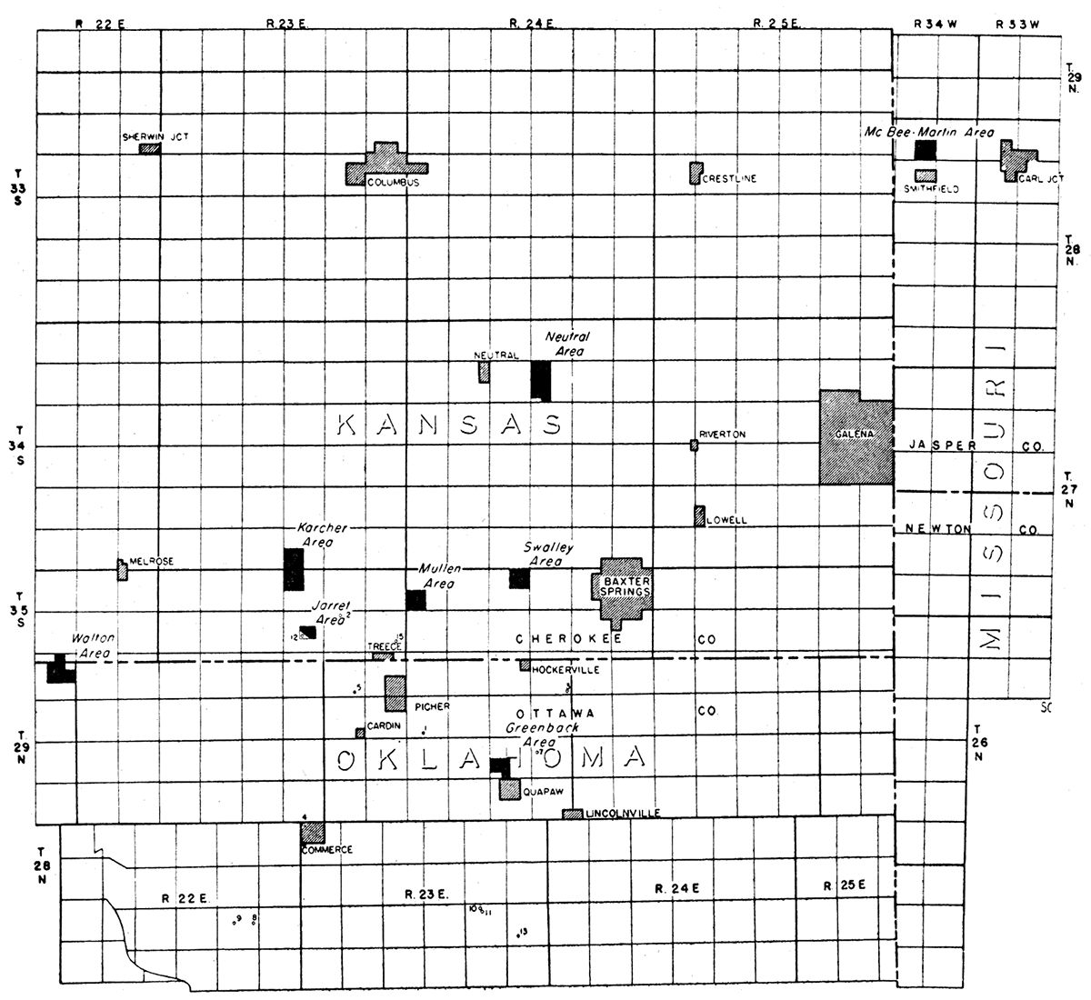
Figure 1 shows the general area covered by the geophysical investigations, and the location of the various areas studied in detail.
Figure 1—Regional map of northwestern part of Tri-State mining district showing location of areas geophysically studied and location of wells from which samples for geochemical analyses were taken.
On the profiles to be presented subsequently with the geophysical results in each area, topography and configuration of the limestone surface have been plotted on a natural scale. The profiles likewise show the position of the boundaries of the general zone of mineralization as projected downward from the surface map. On these profiles, drill hole assays have been projected a maximum of fifty feet to the line of traverse. Mineralization is indicated on the profiles as of "high-grade" or "low-grade." Arbitrary boundaries have been selected for the terms "high-grade" and "low-grade," and the same arbitrary boundaries have been used on all of the profiles. However, it is to be strongly emphasized that the terms "high-grade" and "low-grade" are arbitrary terms and carry no absolute evaluation concerning the' economic value of the ground included within the zone of mineralization.
A discussion of the geology of each area follows.
Neutral Area
The Neutral area (sec. 10, T. 34 S., R. 24 E.) is about a quarter of a mile west of a marked depression in the Miami trough. Geophysical measurements were made along a line trending north-northeastwardly near the western boundary of the section in a portion of the area in which the limestone surface has been mapped as nearly flat (cf. Pierce and Courtier, 1937, pl. 5). The topographic relief along this line is about 40 feet.
The thickness of the shale cover varies from about 100 to 150 feet (Pierce and Courtier, 1937, pl. 5). Drilling in and within a radius of two miles of the traverse area has revealed no mineralization. Geophysical work was done in the Neutral area to determine the type of anomalies to be obtained in an area apparently devoid of mineralization and distant from the mining field. The following geophysical methods were used in the Neutral area: magnetic, gravity, natural potential, resistivity, geothermal, and geochemical.
Mullen Area
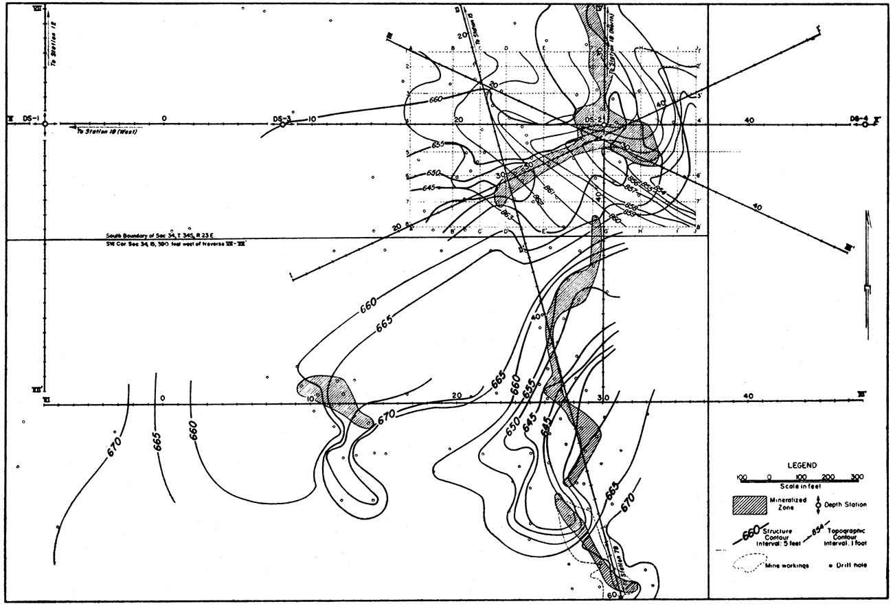
The Mullen area (fig. 2) contains the deepest portion of the Miami trough in Kansas. Geophysical work was done in the Mullen area to determine whether marked buried relief on the subsurface limestone surface can be determined geophysically.
Figure 2—Map showing contours on the top of the limestone, mineralized zones, and traverse lines in the Mullen area.
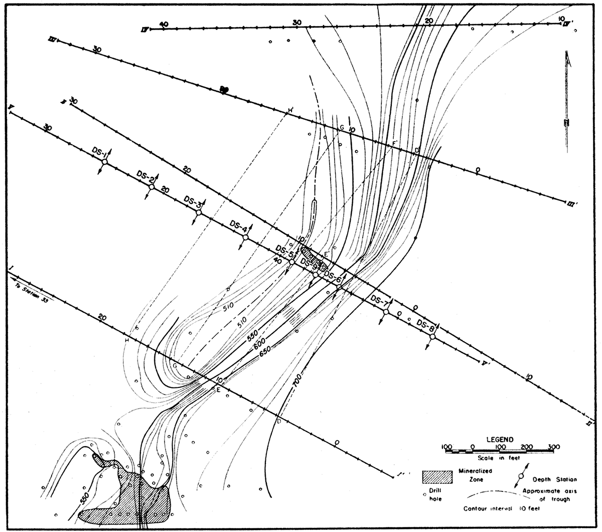
The topographic relief in the portion of the area studied is about 30 feet. The shale has an average thickness of about 175 feet outside of the trough and about 350 feet within the trough. The structural relief of this sharp, northeastwardly trending trough is about 200 feet within an average horizontal distance of about 400 feet in the portion of the area traversed. Data made available to us indicates It small zone of mineralization (largely mined) in the southwestern corner of the property. Because of the previous mining operations and the numerous habitations, no work was done on the southwestern corner of the property. Except for this zone of mineralization, the only other mineralization recorded by the rather extensive drilling is that shown by the four drill holes outlined between traverses I-II' and V-V'. In these holes, galena and sphalerite are found at a depth of about 400 feet or about 50 to 100 feet below the top of the limestone. There is no evidence of Tertiary overburden; in fact, sandstone crops out over a considerable portion of the area traversed.
Figure 2 shows contours on the limestone surface, zones of mineralization, and the various traverse lines used during the geophysical investigations by the following geophysical techniques: magnetic, gravity, natural potential, resistivity, geothermal, and geochemical.
Jarrett Area
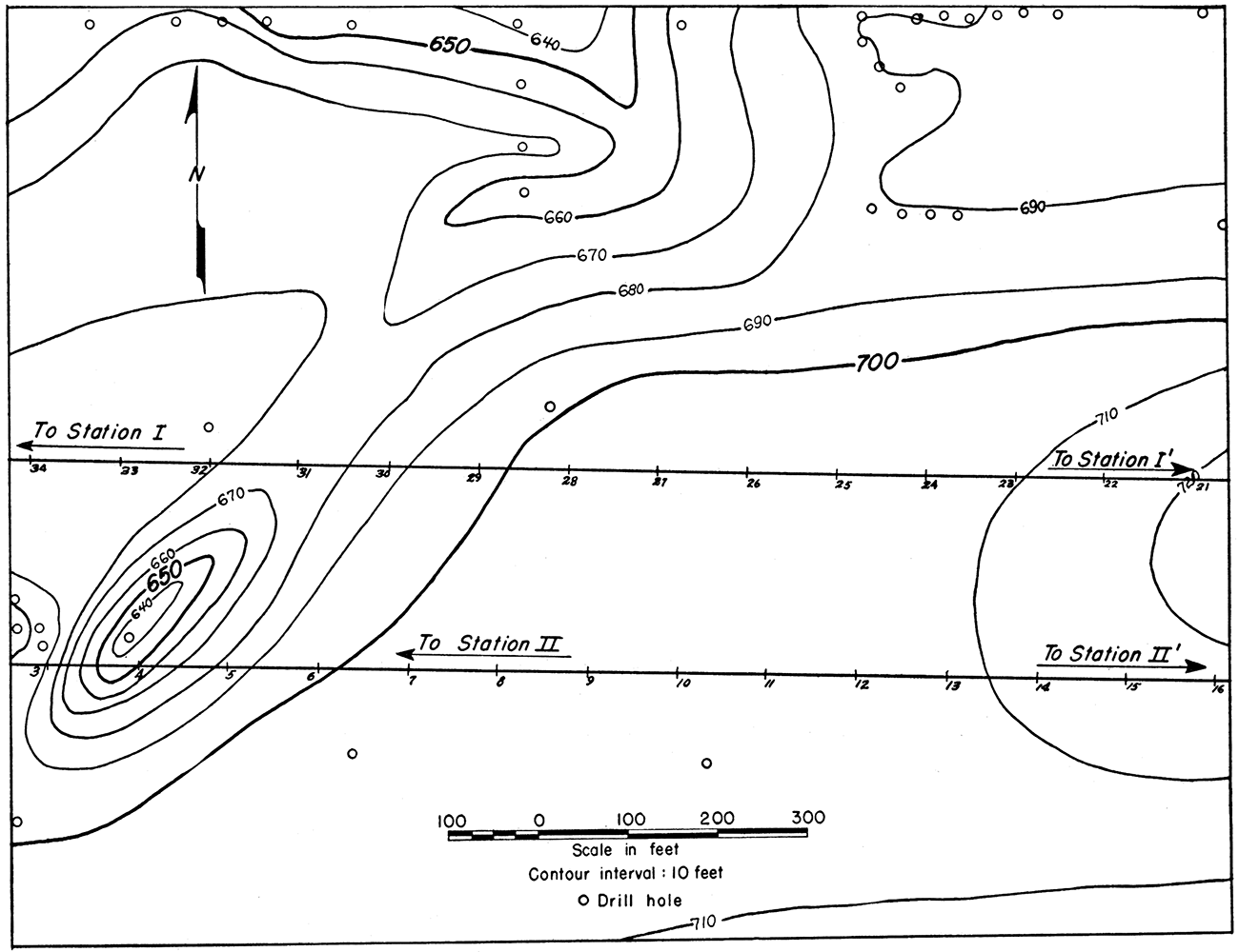
Two east-west gravity-meter traverses were run across the northwestern part of the Federal Jarrett property. These gravity meter results were compared with torsion balance investigations published in 1928 by P. W. George.
The shale cover in the part of the area studied averages about 150 feet in thickness. A northward trending trough cuts the western end of both traverse lines. The structural relief of the trough increases northward.
Figure 3 gives contours showing the elevation of the top of the limestone and shows, also, the two gravity-meter traverse lines.
Figure 3—Map showing contours on the top of the limestone and traverse lines in the Jarrett area.
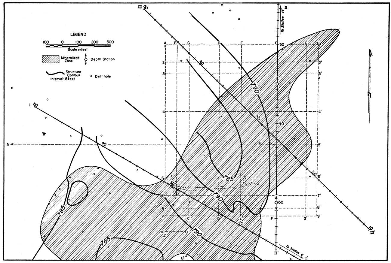
Walton Area
Figure 4 shows topographic contours, contours on the limestone surface, zones of mineralization, and traverse lines on the Walton area. The Walton area has a maximum topographic relief of about 10 feet. There is a pond adjacent to the southern part of the zone of mineralization at the southern end of the area studied. The pond was somewhat of an impediment to the field conduct of the electrical investigations.
Figure 4—Map showing contours on the top of the limestone, topography, mineralized zone, and traverse lines in the Walton area.
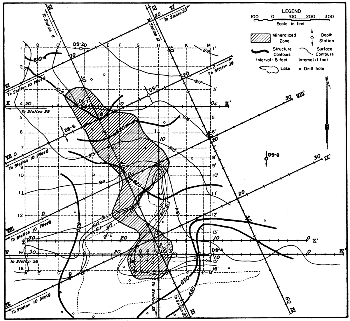
Over the portion of the area studied, the shale-limestone contact has a maximum relief of about 25 feet. The shale has an average thickness of from 175 to 200 feet. Drilling done during the period of this investigation revealed "Tertiary" clays and grave's to a depth of about 30 feet.
The zone of mineralization is of the run type with the mineralization at an average depth of 300 to 350 feet. Many of the drill holes in the zone of mineralization show a relatively high lead: zinc ratio. The boundary between the zone of mineralization and barren ground appears to be somewhat more abrupt than is usual for this district.
The Walton area was studied as an example of a deep, run-type zone of mineralization by the following methods: magnetic, gravity, natural potential, resistivity, geothermal, and geochemical.
Karcher Area
Figure 5 shows topographic contours, contours on the limestone surface, zones of mineralization, and traverse lines on the Karcher area. The Karcher area has a maximum topographic relief of about 10 feet.
Figure 5—Map showing contours on the top of the limestone, topography, mineralized zone, and traverse lines in the Karcher area.
Over the portion of the area studied, the limestone surface has a maximum relief of about 35 feet. The shale has an average thickness of about 200 to 220 feet. It is impossible to ascertain from the available drill logs whether there is any "Tertiary" overburden.
The zone of mineralization is of the run-type with the mineralized zones at an average depth of 350 to 400 feet. Galena occurs in this area in only very minor amounts,
The Karcher area was studied as an example of a deep, run-type zone of mineralization with little lead. The area was studied by the following geophysical methods: magnetic, gravity, natural potential, resistivity, geothermal, and geochemical.
Swalley Area
Figure 6 shows contours on the limestone surface, zones of mineralization, and traverse lines on the Swalley area. The portion of the Swalley area traversed has a maximum topographic relief of about 10 feet.
Figure 6—Map showing contours on the top of the limestone, mineralized zone, and traverse lines in the Swalley area.
The limestone surface has a relief of about 30 feet. The shale has an average thickness of 40 to 80 feet. It is impossible to ascertain from the available drill logs whether there is any "Tertiary" overburden.
The zone of mineralization is of the sheet-ground type with the mineralized zones at an average depth of 300 to 350 feet. Very little galena occurs in this area.
The Swalley area was studied as an example of a deep, sheet-ground type of mineralization with little lead. The area was studied by the following geophysical methods: gravity, resistivity, and geochemical.
Greenback Area
Figure 7 shows contours on the limestone surface, zones of mineralization, and traverse lines on the Greenback area. The portion of the Greenback area traversed has a maximum topographic relief of 10 feet.
Figure 7—Map showing contours on the top of the limestone, mineralized zone, and traverse lines in the Greenback area.
The limestone surface has a relief of about 50 feet. The shale has an average thickness of 15 to 70 feet. In the few cases in which shale is not recorded below the soil and clay at the surface, it is impossible to tell whether the surface soil and clay represent weathered shale or simply weathered limestone. It is likewise not possible to ascertain from the available drill logs whether there is any "Tertiary" overburden.
The zone of mineralization is of the run-type with the mineralized zones at an average depth of 150 to 200 feet. Very little galena occurs in this area.
The Greenback area was studied as an example of a shallow run type of mineralization with little lead. The area was studied by the following geophysical methods: gravity, resistivity, geothermal, and geochemical.
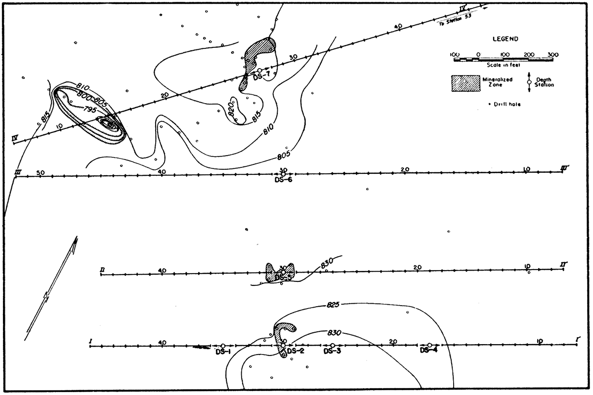
McBee-Martin Area
Figure 8 shows zones of mineralization and traverse lines on the McBee-Martin area. The portion of the McBee-Martin area traversed has a maximum topographic relief of 5 feet.
Figure 8—Map showing mineralized zone and traverse lines in the McBee-Martin area.

The limestone surface has a relief of about 20 feet. The overburden has an average thickness of 20 to 40 feet. It is impossible to tell from the data available whether the overburden is "Tertiary," weathered shale, or weathered limestone.
The mineralized zone is at an average depth of 100 to 160 feet. Very little galena occurs in this area.
The McBee-Martin area was studied as an example of a shallow run-type of mineralization with little lead. The area was studied by the following geophysical methods: gravity, resistivity, and geothermal.
Prev Page—Geography || Next Page—Geophysical Survey
Kansas Geological Survey, Geology
Placed on web Oct. 29, 2018; originally published December, 1942.
Comments to webadmin@kgs.ku.edu
The URL for this page is http://www.kgs.ku.edu/Publications/Bulletins/44/04_geol.html