![]()
Prev Page--Hugoton and Stevens Members || Next Page--Upper Devonian and Lower Mississippian
Revision of Mississippian Stratigraphic Nomenclature in Kansas
by Christopher G. Maples
Abstract
The following changes to the Mississippian stratigraphic nomenclature of Kansas are suggested: 1) the Chattanooga Shale is almost entirely Devonian in age with, perhaps, only the uppermost part early Mississippian; 2) the term Misener Sandstone should be used for a Devonian sandstone at the base of the Chattanooga, not for Mississippian sandstones at the base of the Mississippian carbonates; 3) Hannibal Shale should be used in Kansas instead of Boice Shale; 4) Compton Limestone should be used throughout Kansas instead of the somewhat poorly defined term "Chouteau Limestone," which should be abandoned; 5) Sedalia Formation should be used throughout the state (instead of Sedalia Dolomite); 6) Northview Shale should be used as a formation-rank unit in Kansas, occurring above the Sedalia Formation; 7) the term "Fern Glen Limestone" should be abandoned; 8) St. Joe Limestone Member should be replaced with Pierson Limestone at a formation rank; 9) Reeds Spring Limestone should be elevated from member rank to formation rank; 10) Elsey Formation is recognized only in the extreme southeastern part of Kansas (southeastern Cherokee County) where it is laterally continuous in adjacent parts of Missouri and Oklahoma; 11) Burlington-Keokuk Limestone should be used in those areas where lithostratigraphic separation is not possible; 12) the base of the Meramecian Stage probably occurs within the Warsaw Formation, not at its base as previously placed; 13) the Ste. Genevieve Limestone is Chesterian; 14) Cowley Formation is recognized as a formation-level stratigraphic unit (equivalent to all or part of the St. Louis-upper Chattanooga interval) in the subsurface of south-central Kansas; 15) the St. Louis Limestone in the subsurface of southwestern Kansas is composed of the Hugoton Member below and the Stevens Member above; and 16) the Shore Airport Formation is recognized as the post-Ste. Genevieve Chesterian unit in the subsurface of southwestern Kansas.
Introduction
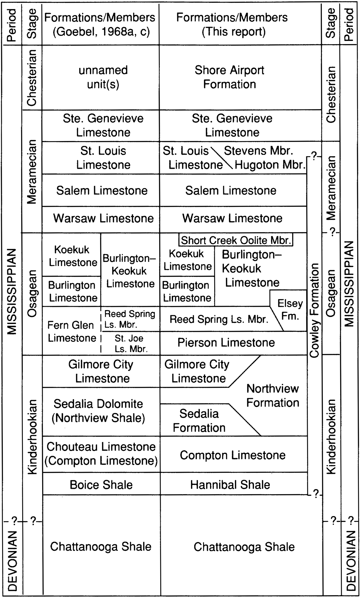
During work on a stratigraphic lexicon for the state of Kansas, it became apparent that Mississippian stratigraphic nomenclature needed to be updated to more closely parallel nomenclature in the type-Mississippian area and to reflect increased understanding of Mississippian surface-exposure stratigraphy in adjacent states. It is neither my intent to erect new names for Mississippian units in Kansas (even though some, such as the "unnamed unites) in the Chesterian," need them), nor to formalize loosely, and often indiscriminately, applied subsurface terms. Rather, I hope to bring Mississippian surface- and subsurface-stratigraphic nomenclature more closely into line with surface-stratigraphic nomenclature. Only those units affected by these changes and updates will be discussed briefly below, from oldest unit upward. A chart summarizing recommended nomenclatural changes is presented in fig. 1.
Because the majority of Mississippian units in Kansas are not exposed at the surface, most of the Mississippian stratigraphic names used in Kansas have been applied to subsurface units. Furthermore, almost all of these subsurface names have been extended from surface exposures in the type-Mississippian area. These subsurface Mississippian units have been important petroleum producers, therefore interest in them has been keen over the years and published works on their stratigraphy are numerous. Two works in particular (Lee, 1940; Goebel, 1968a) have been instrumental in shaping and defining the Mississippian nomenclature used in Kansas. Thompson (1986) updated, clearly defined, and gave nomenclatural histories for Mississippian stratigraphic units in Missouri, which includes a substantial amount of the type-Mississippian area.
Figure 1—Proposed changes in Mississippian stratigraphic nomenclature used in Kansas. North to south distributional changes are represented schematically.
Chattanooga Shale
The Chattanooga Shale is a laterally extensive, easily recognizable black to gray-black shale present in the subsurface throughout most of Kansas (see Goebel, 1968b; Lambert 1992, this volume, for summary of Chattanooga Shale distribution and internal stratigraphy in Kansas). The Chattanooga in Kansas long has been regarded as undifferentiated Devonian and lower Mississippian. However, most of the Chattanooga Shale and equivalents in other states is Devonian in age (Carlson, 1963; McKnight and Fischer, 1970; Over and Barrick, 1990; Over, 1992). Nonetheless, Over and Barrick (1990) and Over (1992) noted that the three lowermost Kinderhookian conodont zones occur within the uppermost meter of the black Woodford Shale (=Chattanooga Shale) in Oklahoma. The majority of the Chattanooga Shale in Kansas is Devonian, as was suggested by Moore et al. (1951), but the uppermost part may be early Mississippian in age (see Lambert, 1992, this volume). Detailed conodont biostratigraphic studies are necessary in order to accurately assess the presence and position of the Devonian-Mississippian boundary in the Chattanooga Shale in Kansas. The subtle change in Kansas of moving the Mississippian-Devonian boundary to near the top of the Chattanooga Shale (fig. 1) reflects increased realization that most of the Chattanooga Shale in adjacent states is Devonian (see Carlson, 1963; Thompson, 1986; Over and Barrick, 1990; Over, 1992).
Related to the age question for the Chattanooga Shale, but not reflected in fig. 1, is the nomenclatural problem of "Misener Sandstone." The Misener Sandstone (without quotation marks) currently is used for the coarse, Devonian siliciclastic unit at the base of the Chattanooga Shale (see Lambert, 1992, this volume). As such, it clearly cannot be younger than Devonian in age. However, "Misener Sandstone" (with quotation marks) has been used in the past for a coarse siliciclastic unit between Mississippian carbonates and either the Chattanooga Shale or older Paleozoic rocks where the Chattanooga Shale is absent (e.g., Goebel, 1968a; Moore, 1983). Whether in all cases this sandstone really is the Misener (Devonian) or some lower Mississippian sandstone (e.g., Bachelor or Bushberg) is equivocal. Clearly, where the Chattanooga Shale rests below this so-called "Misener Sandstone," the "Misener Sandstone" cannot be equivalent to the Misener Sandstone (restricted) that occurs below the Chattanooga Shale. Jewett (1954, p. 84) noted that the Misener Sandstone probably was the Sylamore Sandstone, a view currently shared by T. L. Thompson (written communication, 1990) of the Missouri Geological Survey. In contrast, the "Misener Sandstone" may be a Mississippian sandstone similar to the Bachelor or Bushberg sandstones. However, even if biostratigraphic equivalence with Bachelor or Bushberg sandstones could be demonstrated, I would be reticent to suggest use of either Bachelor or Bushberg in the absence of demonstrated lithostratigraphic continuity.
Hannibal Shale
When Reed (1946) erected the Boice Shale from the subsurface of Nebraska, he did so with the explicit understanding that the subsurface term "Boice" was preferable to the surface term "Hannibal" because no firm correlation from surface to subsurface could be made. Goebel (1968c) adopted Reed's terminology and applied it to the subsurface of Kansas. More recent information (Thompson, 1986, p. 20, 21, 64) has shown that the Hannibal Shale of Keyes (1892) does continue into the subsurface westward from its outcrop area in Missouri and is equivalent to the Boice Shale of Reed (1946). It is recommended that "Boice Shale" be abandoned in favor of the older, more established surface-stratigraphic term "Hannibal Shale" (fig. 1).
Compton Limestone
When Moore (1928, p. 120) erected the Compton Limestone, he noted that the upper beds of the Compton occur in facies relationship with the Northview formation. Goebel (1968c) noted that in southeastern Kansas the Chouteau is called the Compton Limestone. Nodine-Zeller (1987) depicted the Sedalia Dolomite overlying the Chouteau Limestone in Jackson County, Kansas. The term "Chouteau" has had so many different definitions over the years (see summary in Thompson, 1986, p. 34-64) that, as a lithostratigraphic unit, it probably has lost much of its meaning. It is suggested, therefore, that the term "Chouteau" be abandoned altogether (at least until a detailed stratigraphic study of what "Chouteau" really means) and replaced/constrained by "Compton Limestone," the term used in Missouri and southeastern Kansas.
Sedalia Formation
Sedalia Formation is recommended for use in Kansas rather than "Sedalia Dolomite." In addition, the Sedalia Formation occurs below (not above) or instead of (facies relationship with) the Northview Formation (see discussion below under "Northview Formation"). Otherwise, no changes in use of the term "Sedalia" are recommended.
Northview Formation
The Northview Formation was named by Weller (1901) for exposures near Northview, Webster County, Missouri. These exposures are near the northeastern limit of the Northview in Missouri, and occur near the axis of a depositional basin that extends toward the west-northwest into Kansas (see Beveridge and Clark, 1952, fig. 3). Wilson and Berendsen (1988) produced a net-shale map of the Northview Formation in Kansas and found that the shale was thickest (35 ft [10 m]) in the extreme southeastern coiner of Coffey County, in east-central Kansas.
Some discrepancy regarding the relative position of the Northview Formation exists. Moore et al. (1951) and Goebel (1968c, p. 18) noted that "the lower part of the Sedalia Dolomite [=Sedalia Formation] thins southward, and in southeastern Kansas it is equivalent to the Northview Shale." Goebel (1968c, p. 18) also noted that "the upper part of the Sedalia Dolomite consists of noncherty or sparsely cherty, buff to gray dolomite, which extends from outcrops in Missouri westward in the Kansas subsurface to the northeastern flank of the Central Kansas uplift." Conversely, Thompson (1986, p. 58) noted that north of the Northview depositional basin, the Northview Formation "thins rapidly and interfingers with the uppermost beds of the underlying Sedalia Formation" [italics mine]. Thompson (1986, p. 59) also noted that "south of the 'Northview basin' the Northview thins rapidly to 4 to 6 ft of bluish dolomitic siltstone and silty dolomite." When originally proposed, "Sedalia" was used for rocks that were both late Kinderhookian and early Osagean (upper Compton Limestone and Pierson Limestone, as used herein). Beveridge and Clark (1952) restricted "Sedalia" to pre-Osagean dolomitic limestone, beneath the Northview, and the Osagean part of the "Sedalia" was called Pierson. Therefore, as currently understood, all Sedalia is pre- Northview (T. L. Thompson, written communication, 1990). For the purposes of this review and reclassification, the Sedalia Formation is considered to be in facies relationship with the Northview Formation. Where both formations occur, the Sedalia underlies the Northview.
Gilmore City Limestone
The Gilmore City Limestone is recognized only in the subsurface of northern Kansas (e.g., Lee, 1956; Lambert, 1988). Throughout most of the state, the Gilmore City is absent and the Pierson Limestone rests directly on the Northview Shale. Pinch-out of the Gilmore City Limestone from north to south is reflected diagrammatically in fig. 1.
Pierson Limestone
Standard stratigraphic practice in Kansas has been to recognize the Fern Glen Limestone with two members, the Reeds Spring above and the St. Joe below. The Fern Glen Limestone has not been recognized with certainty west of east-central Missouri (see Thompson, 1986, p. 70-74). Therefore, use of the term "Fern Glen" should be abandoned in Kansas because continuity with the type area cannot be demonstrated. The Pierson Limestone of Weller (1901) should be used as a formation-level unit instead of the St. Joe Limestone. Goebel (1968a, p. 1,754) noted the overall similarity of the St. Joe Limestone Member (=Pierson Limestone) in the subsurface of Kansas with outcrops in southwestern Missouri. However, Thompson and Fellows (1970) determined that the basal St. Joe was Kinderhookian and equivalent to the Compton Limestone and Northview Formation of southwestern Missouri, meaning that only upper St. Joe strata in the type area are Osagean. This type of detailed conodont biostratigraphic study is lacking in Kansas, so it is unclear whether or not the Pierson is entirely Osagean or is in part latest Kinderhookian in age.
Reeds Spring Limestone
The Reeds Spring Limestone is raised from member status within the Fern Glen Limestone to formational rank, otherwise, it remains essentially the same as outlined by Goebel (1968a, c), except for recognition of the Elsey Formation in extreme southeastern Kansas (see discussion below) and abandonment of the term "Fern Glen Limestone" (see discussion above).
Elsey Formation
The Elsey Formation was erected by Robertson (1967, p. 46) for the cherty limestone unit that Beveridge and Clark (1952) had called "Grand Falls." Seevers (1975, p. 2-3) noted that the upper part (about 45 ft [13.5 m] thick) of the Reeds Spring Limestone in Cherokee County, Kansas, has been called the Grand Falls Chert, and that the deposits of lead and zinc that were mined throughout the Tri-state district (Missouri-Kansas-Oklahoma) occur primarily in the Grand Falls Chert and overlying rocks of Mississippian age. Thompson (1986, p. 87-89) discussed history of use of the term "Grand Falls" and reasons for use of the better defined term "Elsey." Grand Falls Chert of Winslow (1894) is restricted to the immediate area of the type locality near the center of sec. 28, T. 27 N., R. 34 W., Newton County, Missouri (see Thompson, 1986, p. 88-89). The Elsey Formation is present only in southwestern Missouri, northwestern Arkansas, northeastern Oklahoma, and southeastern Kansas. The Elsey Formation is approximately 30 ft (9 m) thick, overlies the Pierson Limestone or Reeds Spring Formation, and underlies the Burlington-Keokuk Limestone. The Reeds Spring and Elsey Formations and lowermost part of the BurlingtonKeokuk interval all occur in facies relationship with one another and are very difficult to distinguish west and north from the immediate area of southeastern Cherokee County, Kansas. Where Reeds Spring and Elsey cannot be separated, the term Reeds Spring should be used (instead of Reeds Spring-Elsey as used informally by Thompson, 1986, p. 5).
Burlington-Keokuk Limestone
Despite much work, recognition of a distinction between the Burlington and Keokuk limestones in Kansas is difficult in surface exposures and nearly impossible in the subsurface. In earlier works, the Burlington Limestone was assumed to be one of the most extensive Mississippian carbonate units in Kansas (Lee, 1940). More recent works (Goebel, 1968a, c) indicate that in western Kansas, much of what had been called Burlington is in fact Keokuk. Thus, the Keokuk is a much thicker and more widely extensive unit in both surface and subsurface areas than once thought, and certainly more so than the Burlington. The change in depiction of this Burlington-Keokuk relationship (fig. 1) reflects: 1) recognition that the Keokuk is thicker and more widely distributed than the Burlington; and 2) acknowledgment that this contact is not always discernible in the subsurface, thus necessitating a formal term "Burlington-Keokuk" (as opposed to Keokuk-Burlington) to be used in those cases. Where present, the top of the Short Creek Oolite Member marks the base of the Warsaw Limestone. Where absent, or where more than one oolite bed is present, the Warsaw and Burlington-Keokuk contact is difficult to distinguish, which may eventually result in reinstatement of a lithostratigraphic unit that encompasses this whole Warsaw and Burlington-Keokuk package (e.g., "Carthage Limestone" of Gallaher, 1898).
McKnight and Fischer (1970) used the terms "Boone Formation" and "Quapaw Limestone" for most of this sequence and the overlying Warsaw Limestone in the Wyandotte quadrangle, which includes an ~800-ft (240-m) strip of the southernmost part of Kansas. They subdivided the Boone into seven members: St. Joe Limestone Member, Reeds Spring Member, Grand Falls Chert Member, Short Creek Oolite Member, Baxter Springs Member, and Moccasin Bend Member, from bottom to top, respectively. Until detailed mapping in this part of Kansas is done, it probably is best to use the terms Keokuk and Warsaw for this sequence of members in the Boone Formation and overlying Quapaw Limestone.
Cowley Formation
When Lee (1940) erected the Cowley Formation, he did so based in large measure on the assumption that a major glauconitic zone represented a significant unconformity at the base of the Cowley Formation. Clair (1948, 1949) referred to this unit as "Cowley facies" instead because, using lithostratigraphic evidence, he judged Cowley to be a facies of other Mississippian units. Later, Thompson and Goebel (1968), using microfossil evidence, showed that the Cowley Formation of Lee (1940) was temporally equivalent with various Mississippian units from the lower part of the St. Louis Limestone to the Chattanooga Shale. However, none of the standard Mississippian units can be recognized within the "Cowley facies" of Goebel (1968a, c). Conformable relationship and biostratigraphic equivalence, if present, are not reasons to abandon a formation name. Lithologically, the Cowley is so distinctive relative to other Mississippian lithostratigraphic units in Kansas, that resurrection of Lee's (1940) name "Cowley Formation" is recommended (fig. 1). Clearly, additional work on lithostratigraphic definition and biostratigraphic interpretation of the Cowley Formation is warranted. Given the formation thickness (> 500 ft [150 m] in places) and number of Mississippian stages the Cowley represents (Kinderhook-Meramec), detailed investigation may result in subdivision (e.g., Lambert, 1988) and increased understanding of the Cowley Formation.
Hugoton and Stevens Members of the St. Louis Limestone
Abegg (this volume, p. 39-66) has established criteria for recognition of two members in the St. Louis Limestone in the Hugoton embayment of southwestern Kansas. The underlying Hugoton Member is predominantly an evaporitic/dolomitic unit, whereas the overlying Stevens Member is predominantly a muddy fossiliferous limestone. The contact between the underlying Salem Limestone and overlying Hugoton Member of the St. Louis Limestone is marked by the last skeletal and oolitic limestones in the top of the Salem Limestone. The contact between the upper part of the Stevens Member of the St. Louis Limestone and the overlying Ste. Genevieve Limestone is marked by the appearance of quartz-rich limestones in the Ste. Genevieve Limestone. Detailed discussion of these members can be found in Abegg (this volume, p. 39-66).
Shore Airport Formation
Abegg (this volume, p. 21-38) has defined the Shore Airport Formation from cores in southwestern Kansas as Chesterian strata underlain by the Ste. Genevieve Limestone and overlain by the Kearny Formation (Pennsylvanian). The Shore Airport Formation is composed predominantly of maroon and gray mudstones and muddy limestones with features indicative of paleosol development throughout. The Shore Airport Formation is recognized as the appropriate name for that part of the Kansas Chesterian section previously referred to as "unnamed Chester." Detailed discussion of the Shore Airport Formation can be found in Abegg (this volume, p. 21-38).
Meramecian Stage
The upper and lower boundaries of the Meramecian Stage have been the subjects of much debate over the years (see summaries in Horowitz, 1984; Thompson, 1986; Maples and Waters, 1987; Kammer et al., 1989; Kammer et al., 1990). Stage boundaries, unlike the formational boundaries discussed previously, are defined biostratigraphically. I have chosen to use the term "Stage" for both the Meramecian and Chesterian (instead of "Series") because of the general restriction to intracontinental correlation of units referable to "Meramecian" and "Chesterian" (North American Commission on Stratigraphic Nomenclature, 1983, p. 868). The upper boundary of the Meramecian Stage (the Meramecian-Chesterian boundary) most recently has been proposed to coincide with biostratigraphic boundaries between conodonts and foraminiferal zones at approximately the St. Louis-Ste. Genevieve boundary (see Maples and Waters, 1987, 1988; Brenckle et al., 1988). Given the overwhelmingly related faunal similarity between the Ste. Genevieve and younger Chesterian units, the Ste. Genevieve Limestone was removed from the Meramecian Stage and placed in the overlying Chesterian Stage.
The Meramecian-Osagean boundary (the lower Meramecian boundary) has been in an equivalent state of flux to that of the Meramecian-Chesterian boundary (see discussions in Thompson, 1986; Kammeretal., 1990). This has led some state surveys to abandon the terms "Meramecian" and "Osagean" altogether in favor of the collective term "Valmeyeran," which was erected by Moore (1933) and formerly used in Kansas (Moore, 1935). Even though the Osagean-Meramecian boundary does not involve changes in a large number of taxa, I would not favor reintroduction of the "Valmeyeran stage" in Kansas for two reasons. First, as a term, Valmeyer is used by only two state geological surveys (Illinois and Indiana), neither of which border Kansas. Currently, all border and near-border states with Kansas (Oklahoma, Missouri, Nebraska, Colorado, Arkansas, Iowa, New Mexico, Texas) use Osage and Meramec rather than Valmeyer (Sutherland, 1979; Thompson, 1986; Burchett, 1979; Chronic, 1979; Glick, 1979; Avcin and Koch, 1979; Armstrong et al., 1979; Kier et al., 1979). Second, the Osagean-Meramecian contact is the only Mississippian boundary exposed at the surface in Kansas (southeastern Cherokee County). The current Osagean-Meramecian boundary has been judged to be approximately at the Warsaw-Keokuk contact. However, Kammer et al. (1990) have proposed that the Osagean-Meramecian contact be raised stratigraphically to within the Warsaw Formation in the Mississippian stratotype area, which equates roughly to the boundary between the Baxter Springs Member and Moccasin Bend Member of the Boone Formation (as used by McKnight and Fischer, 1970) in northeastern Oklahoma. Because the upper Keokuk and lower Warsaw formations are exposed in Kansas, the revised Osagean-Meramecian boundary probably is present at the surface, although its exact position has not yet been documented. Thus, even though the Osagean-Meramecian boundary may be only fortuitously recognized in the subsurface, the potential for its recognition at the surface is much greater. Figure 1 reflects the occurrence of the Osagean-Meramecian contact at some unknown position within the Warsaw Formation in Kansas, as is the case in the Mississippian stratotype area.
Remaining Questions
As noted above, the purpose of this paper is to update the Kansas Mississippian stratigraphic nomenclature. Clearly additional questions and problems that are beyond the scope of this work remain to be addressed. The nature of the facies relationship between the Cowley Formation and all other pre-Chesterian Mississippian units, although documented, is poorly understood. Facies relationships in the Northview-Sedalia interval and Chouteau-Compton interval are equally poorly investigated. Better biostratigraphic and lithostratigraphic subdivisions of the Chattanooga Shale are critical to understanding this important petroleum source rock. In addition, understanding the age and facies relationships of the sandstone (referred to by some authors as "Misener Sandstone," which it is not) present at the top of the Chattanooga Shale or between older Paleozoic rocks and the base of the Mississippian carbonates is crucial to understanding early Mississippian deposition in Kansas. Detailed biostratigraphic studies (such as Thompson and Goebel, 1968) and subsurface stratigraphic studies of the Mississippian rocks in Kansas are urgently needed. The entire Osagean sequence, in particular, is a very complicated package of facies relationships among no less than five different units that will require careful lithostratigraphic and biostratigraphic study to unravel. Clearly, much remains to be accomplished in the Mississippian of Kansas.
Conclusions
The following changes to the Mississippian stratigraphic terminologies of Kansas are suggested:
- The Chattanooga Shale is almost entirely Devonian in age with, perhaps, only the uppermost part early Mississippian.
- Misener Sandstone should not be used for a sandstone that occurs directly beneath the Mississippian carbonates.
- Hannibal Shale should be used in Kansas instead of Boice Shale.
- Compton Limestone should be used throughout Kansas. The term "Chouteau Limestone" should be abandoned.
- Sedalia Formation should be used throughout the state (instead of Sedalia Dolomite).
- The Northview Shale (as a newly recognized formation-rank unit in Kansas) occurs above the Sedalia Formation in both Missouri and Kansas.
- Use of the term "Fern Glen Limestone" should be discontinued.
- St. Joe Limestone Member should be replaced with Pierson Limestone at a formation rank.
- The Reeds Spring Limestone should be elevated to formation rank from member rank.
- The Elsey Formation is recognized only in the extreme southeastern part of Kansas (southeastern Cherokee County) where it is laterally continuous with Elsey Formation in adjacent parts of Missouri and Oklahoma.
- Burlington-Keokuk Limestone should be used in those areas where lithostratigraphic separation is not possible. Where the two can be separated, usually most of the interval is Keokuk rather than Burlington.
- The base of the Meramecian Stage probably occurs within the Warsaw Formation, not at its base as previously placed.
- The Ste. Genevieve Limestone is Chesterian.
- The Cowley Formation is reinstated as a formation-level stratigraphic unit (equivalent to all or part of the lower St. Louis-upper Chattanooga interval) in the subsurface of south-central Kansas.
- Two Members of the St. Louis Limestone in the Hugoton embayment, southwestern Kansas, are recognized: the Hugoton Member in the lower part and the Stevens Member in the upper part.
- The Shore Airport Formation is recognized as the post-Ste. Genevieve part of the Chesterian strata in the subsurface of southwestern Kansas.
Acknowledgments
Many thanks are extended to F. E. Abegg, J. Doveton, H. R. Feldman, E. D. Goebel, M. L. Lambert, K. D. Newell, K. D. Parham, T. L. Thompson, and W. L. Watney for reviews of all or parts of this manuscript and valuable discussions. Thanks also go to Renate Hensiek for drafting fig. 1.
References
Armstrong, A. K., Kottlowski, F. E., Stewart, W. J., Mamet, B. L., Baltz, E. H., Jr., Siemers, W. T., and Thompson, S., III, 1979, The Mississippian and Pennsylvanian (Carboniferous) Systems in the United States—New Mexico: U.S. Geological Survey, Professional Paper 1110-W, 27 p. [available online]
Avcin, M. J., and Koch, D. L., 1979, The Mississippian and Pennsylvanian (Carboniferous) Systems in the United States—Iowa: U.S. Geological Survey, Professional Paper 1110-M, 13 p. [available online]
Beveridge, T. R., and Clark, E. L., 1952, A revision of the early Mississippian nomenclature in western Missouri; in, Kansas Geological Society, Guidebook, 16th Regional Field Conference, West-central Missouri: Missouri Geological Survey and Water Resources, Report of Investigations 13, p. 71-80.
Brenckle, P. L., Baesemann, J. F., Woodson, F. J., Baxter, J. W., Carter, J. L., Collinson, C., Lane, H. R., Norby, R. D., and Rexroad, C. B., 1988, Comment [on "Redefinition of the Meramecian/Chesterian boundary (Mississippian)," by C. G. Maples and J. A. Waters]: Geology, v. 16, p. 470-471
Burchett, R. R., 1979, The Mississippian and Pennsylvanian (Carboniferous) Systems in the United States-Nebraska: U.S. Geological Survey, Professional Paper 1110-P, 15 p. [available online]
Carlson, M. P., 1963, Lithostratigraphy and correlation of the Mississippian System in Nebraska: Nebraska Geological Survey, Bulletin 21, 46 p.
Chronic, J., 1979, The Mississippian and Pennsylvanian (Carboniferous) Systems in the United States—Colorado: U.S. Geological Survey, Professional Paper 1110-V, 25 p. [available online]
Clair, J. R., 1948, Preliminary notes on lithologic criteria for identification and subdivision of the Mississippian rocks in western Kansas: Kansas Geological Society, 14 p.
Clair, J. R., 1949, Lithologic criteria of Mississippian rocks in western Kansas: World Oil, v. 122, no. 8, p. 61-62, 64, 66
Gallaher, J. A., 1898, Biennial report of the Bureau of Geology and Mines: Missouri Bureau of Geology and Mines, 68 p.
Glick, E. E., 1979, Geologic setting; in, The Mississippian and Pennsylvanian (Carboniferous) Systems in the United States—Arkansas, B. R. Haley, E. E. Glick, W. M. Caplan, D. F. Holbrook, and C. G. Stone: U.S. Geological Survey, Professional Paper 1110-O, p. 03-07 [available online]
Goebel, E. D., 1968a, Mississippian rocks of western Kansas: American Association of Petroleum Geologists, Bulletin, v. 52, p. 1,732-1,778
Goebel, E. D., 1968b, Undifferentiated Silurian and Devonian; in, The Stratigraphic Succession in Kansas, D. E. Zeller, ed.: Kansas Geological Survey, Bulletin 189, p. 15-17 [available online]
Goebel, E. D., 1968c, Mississippian System; in, The Stratigraphic Succession in Kansas, D. E. Zeller, ed.: Kansas Geological Survey, Bulletin 189, p. 17-21. [available online]
Horowitz, A. S., 1984, Some notes on larger invertebrates and the Genevievian-Chesterian boundary: Compass, v. 62, p. 8-15
Jewett, J. M., 1954, Oil and gas in eastern Kansas: Kansas Geological Survey, Bulletin 104, 397 p.
Kammer, T. W., Ausich, W. I., and Carter, J. L., 1989, Biostratigraphy of the Osagean-Meramecian boundary in the Mississippian stratotype region: Geological Society of America, Abstracts with Programs, v. 21, no. 6, p. A 132
Kammer, T. W., Brenckle, P. L., Carter, J. L., and Ausich, W. I., 1990, Redefinition of the Osagean-Meramecian boundary in the Mississippian stratotype region: Palaios, v. 5, p. 414-431
Keyes, C. R., 1892, The principal Mississippian section: Geological Society of America, Bulletin, v. 3, p. 283-300
Kier, R. S., Brown, L. F., Jr., and McBride, E. F., 1979, The Mississippian and Pennsylvanian (Carboniferous) Systems in the United States—Texas: U.S. Geological Survey, Professional Paper 1110-S, 45 p. [available online]
Lambert, M. W., 1988, Sub-Pennsylvanian subcrop map of Mississippian units in the Salina basin: Kansas Geological Survey, Open-file Report 88-37, 6 p. [available online]
Lambert, M. W., 1992, Lithology and geochemistry of shale members within the Devonian-Mississippian Chattanooga (Woodford) Shale, midcontinent, USA: Kansas Geological Survey, Open-file Report 92-26, 163 p.
Lee, W., 1940, The subsurface Mississippian rocks of Kansas: Kansas Geological Survey, Bulletin 33, 114 p. [available online]
Lee, W., 1956, Stratigraphy and structural development of the Salina basin area: Kansas Geological Survey, Bulletin 121, 167 p. [available online]
McKnight, E. T., and Fischer, R. P., 1970, Geology and ore deposits of the Picher field, Oklahoma and Kansas: U.S. Geological Survey, Professional Paper 588, 165 p. [available online]
Maples, C. G., and Waters, J. A., 1987, Redefinition of the Meramecian/Chesterian boundary (Mississippian): Geology, v. 15, p. 647-651
Maples, C. G., and Waters, J. A., 1988, Reply [to Comment on "Redefinition of the Meramecian/Chesterian boundary (Mississippian)," by P. L. Brenckle and others]: Geology, v. 16, p. 471-472
Moore, G., 1983, Hugoton embayment—Kansas; in, Correlation of Stratigraphic Units of North America (COSUNA), Southwest/Southwest Midcontinent Region, J. M. Hills and F. E. Kottlowski, regional coordinators: American Association of Petroleum Geologists, col. 29
Moore, R. C., 1928, Early Mississippian formations in Missouri: Missouri Bureau of Geology and Mines, v. 21, series 2, 283 p.
Moore, R. C., 1933, Historical geology: McGraw-Hill Book Company, Inc., New York, 673 p.
Moore, R. C., 1935, Rock formations of Kansas: Kansas Geological Survey, Open-file Report 35-1, 1 pl.
Moore, R. C., Frye, J. C., Jewett, J. M., Lee, W., and O'Connor, H. G., 1951, The Kansas rock column: Kansas Geological Survey, Bulletin 89, 132 p. [available online]
Nodine-Zeller, D. E., 1987, Jackson County, Kansas; in, Correlation of Stratigraphic Units of North America (COSUNA), Midcontinent Region, F. J. Adler, regional coordinator: American Association of Petroleum Geologists, col. 21
North American Commission on Stratigraphic Nomenclature, 1983, North American stratigraphic code: American Association of Petroleum Geologists, Bulletin, v. 67, p. 841-875
Over, D. J., 1992, Conodonts and the Devonian-Carboniferous boundary in the upper Woodford Shale, Arbuckle Mountains, south-central Oklahoma: Journal of Paleontology, v. 66, p. 293-311
Over, D. J., and Barrick, J. E., 1990, The Devonian/Carboniferous boundary in the Woodford Shale, Lawrence uplift, south-central Oklahoma; in, S.M. Ritter (ed.), Early to Middle Paleozoic Conodont Biostratigraphy of the Arbuckle Mountains, Southern Oklahoma, S. M. Ritter, ed.: Oklahoma Geological Survey, Guidebook 27, p. 63-73
Reed, E. C., 1946, Boice shale, new Mississippian subsurface formation in southeast Nebraska: American Association of Petroleum Geologists, Bulletin, v. 30, p. 348-352
Robertson, C. E., 1967, The Elsey Formation and its relationship to the Grand Falls Chert: Missouri Geological Survey and Water Resources, Report of Investigations 38, 62 p.
Seevers, W. J., 1975, Description of the surficial rocks in Cherokee County, southeastern Kansas: Kansas Geological Survey, Geology Series 1, 7 p. [available online]
Sutherland, P. K., 1979, Mississippian and Lower Pennsylvanian stratigraphy; in, The Mississippian and Pennsylvanian (Carboniferous) Systems in the United States—Oklahoma, R. O. Fay, S. A. Friedman, K. S. Johnson, J. F. Roberts, W. D. Rose, and P. K. Sutherland: U.S. Geological Survey, Professional Paper 1110-R, p. R9-R18 [available online]
Thompson, T. L., 1986, Paleozoic succession in Missouri, Part 4—Mississippian System: Missouri Department of Natural Resources, Division of Geology and Land Survey, Report of Investigations 70, Part 4, 189 p.
Thompson, T. L., and Fellows, L. D., 1970, Stratigraphy and conodont biostratigraphy of Kinderhookian and Osagean rocks of southwestern Missouri and adjacent areas: Missouri Geological Survey and Water Resources, Report of Investigations 45, 263 p.
Thompson, T. L., and Goebel, E. D., 1968 [1969], Meramecian conodonts and stratigraphy of Kansas: Kansas Geological Survey, Bulletin 192, 56 p. [available online]
Weller, S., 1901, Correlation of the Kinderhook formations of southwestern Missouri: Journal of Geology, v. 9, p. 130-148
Wilson, M. E., and Berendsen, P., 1988, Net shale map of Northview Shale: Kansas Geological Survey, Open-file Report 88-5, 1 pl. [available online]
Winslow, A., 1894, Lead and zinc deposits: Missouri Geological Survey, Vols. 6-7, 763 p.
Prev Page--Hugoton and Stevens Members || Next Page--Upper Devonian and Lower Mississippian
Kansas Geological Survey, Geology
Placed on web Nov. 29, 2018; originally published April 1994.
Comments to webadmin@kgs.ku.edu
The URL for this page is http://www.kgs.ku.edu/Publications/Bulletins/230/07_miss.html