Kansas Geological Survey, Bulletin 211, Part 3, originally published in 1977
Originally published in 1977 as Kansas Geological Survey Bulletin 211, Part 3. This is, in general, the original text as published. The information has not been updated.
Endothyrid foraminifers and conodonts were used for determination of the age of a core in the Eagle-Picher Industries, Inc. #1 Velie Swalley test hole, which reached a total depth of 76 feet (23.16 m) in SW SW NW sec. 3, T. 35 S., R. 24 E., Cherokee County, Kansas. Mississippian limestone from 75.8 feet (23.1 m) to 50.5 feet (15.4 m) includes beds of Meramecian and possible Chesteran age. Pennsylvanian black fissile shale from 50.5 feet to 37 feet (11.3 m) is Atokan(?) in age. Surface weathering, producing tan to yellowish-brown, iron-stained clay with recent root impressions, penetrates to about 37 feet.
The #1 Swalley lies on the northwestern flank of the Ozark uplift, an irregular domal structure lying in Missouri, northwestern Arkansas, northeastern Oklahoma, and the extreme southeastern tip of Kansas. The difference in elevation of Keokuk (Osagean Stage, Lower Mississippian) beds on the east side of Cherokee County and Salem-St. Louis (Meramecian Stage, Upper Mississippian) and Keokuk beds eight miles to the west in the #1 Swalley is possibly due to faulting and/or folding of these Mississippian beds, which may have been an avenue for implacement of lead and zinc ores in the Tri-State area.
The Eagle-Picher #1 Velie Swalley 4-inch (10.2 cm) continuous core was taken in SW SW NW sec. 3, T. 35 S., R. 24 E., Cherokee County, Kansas (Fig. 1), to a total depth (TD) of 76 feet (23.16 m). The hole was drilled 400 feet (121.9 m) north of the entrance to the Paxson-Stoskopf-Swalley incline mine. Eagle-Picher geologists described a highly weathered zone of sandy yellow-brown shale, gray, silty clay, and somewhat laminated, slightly weathered gray to black shale which was encountered from the surface to about 41.5 feet (12.6 m). From this depth to 50.2 feet (15.3 m) black, pyritic, fissile shale was logged. The above interval has been interpreted as "Cherokee" (Middle Pennsylvanian) by geologists who have worked in the Tri-State lead and zinc area. The "top of the Chester limestone" (Upper Mississippian) was logged by Eagle-Picher geologists at 50.2 feet. This limestone (50.2 to 75.8 feet) was described by them as (descending) dark-gray, pyritic, light-gray fossiliferous, becoming slightly permeated with "dead" oil from 65 feet (19.8 m) down, stylolitic at intervals, and with blue-gray chert blebs appearing at 75.8 feet to TD. A nearby Eagle-Picher hole, core #2, TD 63.4 feet (19.3 m), W SW NW sec. 3, T. 35 S., R. 24 E., logged the "top of the Chester" at 53.1 feet (16.2 m).
Figure 1--Map showing deformation of southwestern half of the Ozark uplift and location of Eagle-Picher #1 Velie Swalley in Cherokee County, Kansas. Contours on approximate base of Mississippian above sea level. (Adapted from Siebenthal, 1915).
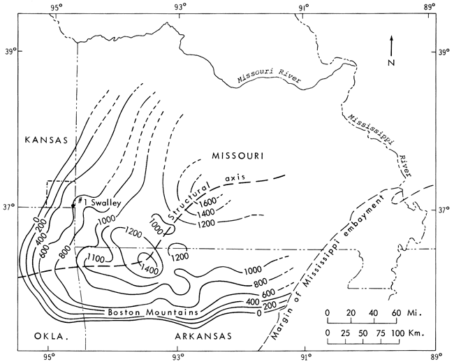
The area of the #1 Velie Swalley core lies on the northwestern flank of the Ozark uplift, an irregular domal structure lying in Missouri, northwestern Arkansas, northeastern Oklahoma, and the extreme southeastern tip of Kansas (Fig. 1). This uplift has been structurally active intermittently from Cambrian time into the Pliocene (Siebenthal, 1915; Bretz, 1965). Its post-"Boone"-pre- and post-Cherokee movements bear an intimate time and stratigraphic relationship to implacement of lead and zinc ores in the Tri-State district (Smith and Siebenthal, 1907; Brockie, Hare, and Dingess, 1968; McKnight and Fischer, 1970).
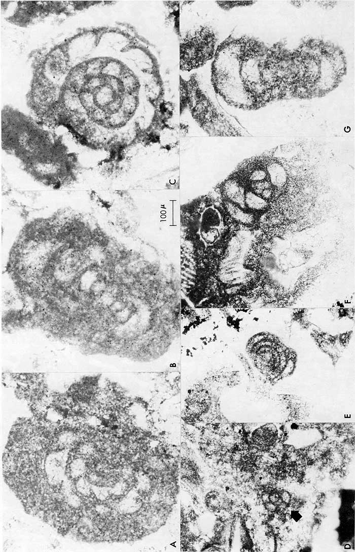
Nodine-Zeller examined and described the entire core (Fig. 2). Thin-sections were made of the limestones from 50.5 to 75.8 feet in a search for endothyrid foraminifers. Faunal elements at 74-75 feet (22.6-22.9 m) in the #1 Velie Swalley well core seem to be predominantly Meramecian in age (Pl. 2, A,B,C,E,G) and include "Endothyra" spiroides?, "E." symmetrica, Tournayella, Polypora and other bryozoans, Glomospira, ostracodes, and algae. Questionable reworking and mixing of Meramecian and Chesteran microfossils occurs from about 68 feet (20.7 m) to the top of the limestone. Definite Chesteran-age plectogyrids occur at 57 feet (17.4 m) (Pl. 2, D,F). Beds of intensely broken, minute fossil fragments occur at 73-66 feet (22.3-20.1 m) (Pl. 1, A). None of these finely broken fragments could be identified as to origin, except for a few extremely small plectogyrids (Pl. 1, A) that survived intact because they were the same particle size as the matrix. Limestones from 65 feet to about 50 feet (19.8 to 15.3 m) (Pl. 1, B-H) contain larger, more normal-sized fossil fragments of bryozoans, crinoid/blastoid plates, corals, echinoid spines, algae, brachiopods, and foraminifers. Most of the calcareous fossils show signs of reworking and subaerial weathering, e.g., rounding, fragmentation, intensive recrystallization of original calcite, and replacement by pyrite (Pl. 2). Earlier workers (Smith and Siebenthal, 1907; Thompson and Goebel, 1968) mention possible regression of seas in late Meramecian time and erosion of Meramecian rocks prior to or during deposition of Chesteran beds. In southwestern Missouri and northwestern Arkansas, Chesteran strata rest directly on late Osagean Keokuk beds with definite disconfomity (Thompson, 1972). Other workers also have recognized erosion and reworking of intervals within the Chesteran.
Figure 2--Lithostratigraphic units and endothyrid and tournayellid foraminifers encountered in Eagle-Picher #1 Velie Swalley core, SW SW NW sec. 3, T. 35 S., R. 24 E., Cherokee County, Kansas. Surface elevation 849.16 feet. Completed January 4, 1968.
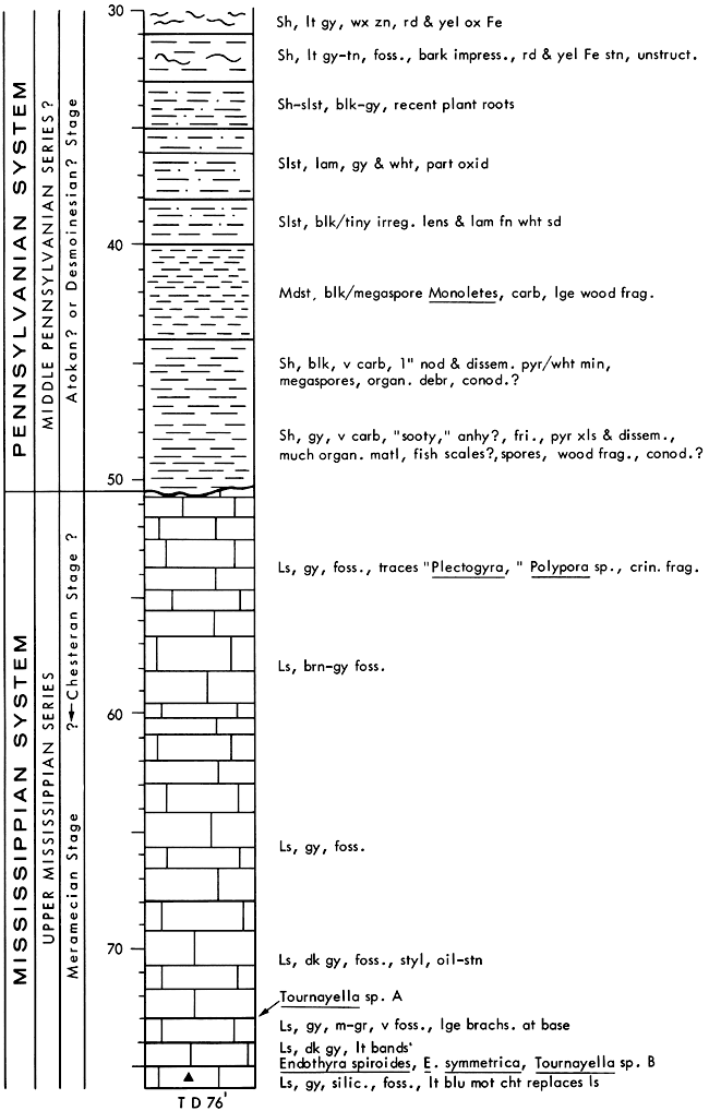
The interval from 75 to 68 feet (22.9 to 20.7m) yielded "Endothyra" spiroides Zeller, an index to beds of lower Meramecian age, that are equivalent to Salem beds elsewhere (Nodine-Zeller, 1972); also occurring here are "E." symmetrica Zeller, and species of Tournayella with Meramecian affinities (Fig. 2; Pl. 2, E). Nodine-Zeller (1972) previously described and illustrated "E." spiroides and "E." symmetrica from a well core in Scott County, Kansas, and in a core from Bindley Field, Hodgeman County, Kansas (Ebanks, Euwer, and Nodine-Zeller, 1977).
The contact between the limestone and the overlying black shale in the core is sharp and disconformable. In the shale (Pennsylvanian in age) at about 50 to 42 feet (15.2 to 12.8 m), the megaspore Monoletes, sp., was found. Winslow (1950, p. 62) states that "Monoletes is not represented in upper Mississippian coals. . ." but was "commonly represented in two coals . . . and sparsely represented in other coals of the Caseyville Group." Caseyville in Illinois is considered to be Morrowan in age (Willman, et al., 1975). Since Monoletes is long-ranging and its taxonomic position is uncertain, its usefulness as an age indicator is limited at this time. However, there may be microspores in the black shales, and certain of these microfossils are known to be reliable age indicators in Mississippian and Pennsylvanian sediments (Wilson, L. R., Department of Geology, University of Oklahoma, personal communication, Sept., 1976).
Plate 1--Thin sections showing lithology of Mississippian limestone portion of #1 Velie Swalley core, SW SW NW sec., 3, T. 35 S., R. 24 E., Cherokee County, Kansas. A, Bioclastic grainstone composed of abraided silt-sized fossil fragments, depth 73 feet (22.3 m); arrow points to minute endothyrid foraminifer. B-H, Highly recrystallized bioclastic grainstone; fossils very poorly preserved, most pyritized, consisting of algae, foraminifers, brachiopods, ostracodes, and pelmatazoan plates, depth 74-75 feet (22.6-22.9 m). B, Bryozoan, brachiopod, and crinoid fragments, dark objects are pyritized fossils; C, Fragment of a brachiopod in lower part of photomicrograph, arrow points to pyritized endothyrid; D, In upper right, fragment of brachiopod umbonal region, arrow points to pyritized endothyrid; E, Fenestellid bryozoan, showing fragmentation and pressure recrystallization and mixing with pelmatazoan plates; F, Arrows point to two highly pyritized endothyrids, light, oval-shaped fossil on which one arrow rests is tangential section of holothurian spine (black dots are ink used to locate foraminifers for photomicrography); G, Crinoid or blastoid ossicle at left, brachiopod fragment center-right, black areas pyritized foraminifers and other fossils, light areas clear recrystallized calcite; H, Intensely broken fossils, one a section of the bryozoan Polypora, the other a rounded, reworked clast of an alga?, both pyritized, white areas clear calcite. (Photomicrography and printing of negatives of these thin sections was difficult. "Dodging" technique was used in some cases to even out tone in final photograph. When photographs were developed to show texture of sample, all pyritized fossils turned as dark as ink blobs in F. Thus, lines showing twinning planes of calcite could not be shown.)
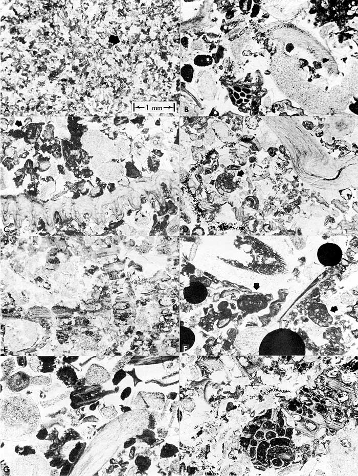
Plate 2--Typical foraminifers recovered from the #1 Velie Swalley limestone core, SW SW NW sec. 3, T. 35 S., R. 24 E., Cherokee County, Kansas. A-B, "Endothyra" spiroides Zeller, a Salem zone marker. Depth, 74-75 feet (22.6-22.9 m). In E. spiroides a part of one volution is missing due to recrystallization. C,G, "Endothyra" symmetrica Zeller, which probably ranges from Meramecian into Chesteran. Depth, 74-75 feet. In C and G, E. symmetrica should have at least 4 volutions. They are missing due to recrystallization caused by subaerial weathering. D, Minute planispiral endothyrid with Chesteran affinities. Depth, 56 feet (17.1 m). E, Tournayella sp. with Meramecian affinities. Depth, 74-75 feet; F, "Pectogyra" sp. with Chesteran affinities. Depth, 57 feet (17.4 m). All dark specks in photomicrographs are pyrite, disseminated and accreted. Indeed, the very walls of the endothyrids are composed of flecks of pyrite replacing the original calcite structure.
Thompson extracted conodonts from the #1 Swalley core for age determinations. The following description (Table 1) of the limestone (Mississippian) portion of the core was logged by Thompson (Missouri Geol. Survey section 1314-58). Conodonts recovered from limestone from 51-75 feet (15.5-22.9 m) (Fig. 3) include the characteristic form species Apatognathus porcatus (Hinde), Gnathodus texanus Roundy, and Taphrognathus varians Branson and Mehl, and species of Cavusgnathus. According to the latest conodont faunal evaluations of Mississippian strata (Collinson, Rexroad, and Thompson, 1971), this fauna is indicative of a Meramecian age. G. texanus and T. varians are the dominant platform elements from the upper Osagean into lower upper Meramecian strata. In the Upper Mississippi Valley, this includes from the base of the Keokuk Limestone into the lower part of the St. Louis Limestone (Fig. 4). This fauna is then replaced by one dominated by species of Cavusgnathus and A. porcatus, A. scalenus Varker, and Spathognathodus scitulus (Hinde). Although the latter three forms are short-ranging and are not found above the St. Louis in the Upper Mississippi Valley, Cavusgnathus is abundant to the top of the Mississippian System, and even ranges into the Pennsylvanian, and G. texanus reappears in lower Chesteran strata in southwestern Missouri (Thompson, 1972). In a zonal scheme (Collinson, Rexroad, and Thompson, 1971, p. 381-382), the position of the fauna of the #1 Velie Swalley core is at approximately the zonal boundary between the lower Taphrognathus varians-Apatognathus Zone and the upper Apatognathus scalenus-Cavusgnathus Zone (T. varians-Apatognathus? and A.? geminus-Cavusgnathus zones of Thompson and Goebel [1968, p. 18-191).
Table 1--Lithologic description of the limestone (Mississippian) portion of the #1 Velie Swalley core taken by Eagle-Picher Industries, Inc., in SW SW NW sec. 3, T. 35 S., R. 24 W., Cherokee County, Kansas. See Fig. 3 for occurrence of conodonts in these beds.
| Depth, in feet |
Description |
|---|---|
| 50.5-52.5 (15.4-16.0 m) |
Limestone, gray to dark-gray; gray part very fine-grained, dense, dark-gray part medium-grained fossiliferous, dense, with finely crystalline matrix. Top 1-foot very fine-grained. |
| 52.5-63 (16.0-19.2 m) |
Limestone, brown-gray, fine- to medium-grained; some beds very porous (bryozoa). Some coarsely grained, crinoidal; very fossiliferous, particularly around 55'. More porous toward top. Some siliceous 55-56'. Grades upward into next unit. |
| 63-68 (19.2-20.7 m) |
Limestone, gray, medium-grained, fossiliferous, crinoidal, very uniform grain size entire 5'; very dense. Top and base at stylolites. |
| 68-73 (20.7-22.3 m) |
Limestone, dark-gray, very fine-grained, occasional fine-grained lenses; fossiliferous; numerous stylolites. Some oil stain. |
| 73 (22.3 m) |
Limestone, gray, medium-grained, very fossiliferous, numerous large brachiopods at base. Base at stylolite. |
| 74-75 (22.6-22.9 m) |
Limestone, dark-gray, with light-gray bands (dark part oil stains), very dense, fine-grained. Top at stylolite. |
| 75 (22.9 m) |
Limestone and chert. Limestone, gray, very fine-grained, siliceous, porous, fossiliferous? Chert, light-blue, mottled, partially replaces limestone. |
Figure 3--Conodonts recovered mainly from limestone portion (Mississippian) of the Eagle-Picher #1 Velie Swalley core, SW SW NW sec. 3, T. 35 S., R. 24 E., Cherokee County, Kansas.
| Depth, feet |
Idiognathodus delicatus |
Neognathodus colombiensis |
Apatognathus sp. |
Cavusgnathus altus |
C. convexus |
C. regularis |
C. unicornis |
|---|---|---|---|---|---|---|---|
| Pennsylvanian | |||||||
| 49 | 41 | 1 | |||||
| 50 | 2 | ||||||
| 50.5 | 48 | 4 | |||||
| Mississippian | |||||||
| 51 | |||||||
| 52 | 1 | ||||||
| 53 | 2 | ||||||
| 54 | |||||||
| 55 | |||||||
| 56 | |||||||
| 57 | |||||||
| 58 | |||||||
| 59 | |||||||
| 60 | |||||||
| 61 | 1 | 1 | |||||
| 62 | 1 | 2 | |||||
| 63 | 1 | 1 | |||||
| 64 | 1 | 3 | |||||
| 65 | 1 | ||||||
| 66 | |||||||
| 67 | 1 | ||||||
| 68 | |||||||
| 69 | 2 | 3 | |||||
| 70 | |||||||
| 71 | 3 | ||||||
| 72 | 1 | 2 | 2 | ||||
| 73 | 2 | 2 | |||||
| 74 | 2 | ||||||
| 75 | |||||||
| Depth, feet |
Cavusgnathus fragments |
Gnathodus texanus |
Spathognathodus cristulus |
Taphrognathus varians |
Hibbardella milleri |
H. ortha |
Lonchodina furnishi |
|---|---|---|---|---|---|---|---|
| Pennsylvanian | |||||||
| 49 | |||||||
| 50 | |||||||
| 50.5 | |||||||
| Mississippian | |||||||
| 51 | 3 | ||||||
| 52 | 2 | 1 | |||||
| 53 | 1 | ||||||
| 54 | |||||||
| 55 | 1 | ||||||
| 56 | |||||||
| 57 | |||||||
| 58 | |||||||
| 59 | |||||||
| 60 | |||||||
| 61 | |||||||
| 62 | 1 | 1 | |||||
| 63 | 1 | ||||||
| 64 | 1 | 2 | 1 | ||||
| 65 | 1 | 1 | |||||
| 66 | 2 | ||||||
| 67 | 1 | ||||||
| 68 | 1 | ||||||
| 69 | 3 | 1 | |||||
| 70 | 1 | ||||||
| 71 | 1 | ||||||
| 72 | 1 | ||||||
| 73 | 1 | ||||||
| 74 | |||||||
| 75 | |||||||
| Depth, feet |
Neoprioniodus tulensis |
N. varians |
Ozarkodina compressa |
Hindeodella sp. |
Hibbardella sp. |
Lambdagnathus sp. |
Ligonodina sp. |
|---|---|---|---|---|---|---|---|
| Pennsylvanian | |||||||
| 49 | |||||||
| 50 | |||||||
| 50.5 | |||||||
| Mississippian | |||||||
| 51 | |||||||
| 52 | 5 | 2 | 5 | ||||
| 53 | 2 | 5 | |||||
| 54 | |||||||
| 55 | 1 | ||||||
| 56 | |||||||
| 57 | |||||||
| 58 | |||||||
| 59 | |||||||
| 60 | 2 | 2 | 2 | ||||
| 61 | 1 | ||||||
| 62 | 3 | 1 | 2 | ||||
| 63 | 1 | 3 | |||||
| 64 | 4 | 3 | |||||
| 65 | 2 | 1 | 1 | 1 | |||
| 66 | |||||||
| 67 | 2 | 1 | 1 | 1 | |||
| 68 | 1 | ||||||
| 69 | 1 | 1 | 3 | ||||
| 70 | 2 | ||||||
| 71 | 4 | 5 | |||||
| 72 | 2 | 2 | 2 | ||||
| 73 | 2 | ||||||
| 74 | 1 | ||||||
| 75 | |||||||
| Depth, feet |
Lonchodina sp. |
Magnilaterella sp. |
Metalonchodina sp. |
Neoprioniodus sp. |
Ozarkodina sp. |
Holmesella sp. |
Fish tooth |
|---|---|---|---|---|---|---|---|
| Pennsylvanian | |||||||
| 49 | 2 | ||||||
| 50 | 1 | 1 | |||||
| 50.5 | 2 | ||||||
| Mississippian | |||||||
| 51 | |||||||
| 52 | 3 | 1 | |||||
| 53 | |||||||
| 54 | |||||||
| 55 | |||||||
| 56 | 1 | ||||||
| 57 | |||||||
| 58 | |||||||
| 59 | |||||||
| 60 | |||||||
| 61 | |||||||
| 62 | |||||||
| 63 | |||||||
| 64 | 2 | ||||||
| 65 | |||||||
| 66 | |||||||
| 67 | |||||||
| 68 | |||||||
| 69 | 1 | ||||||
| 70 | |||||||
| 71 | 1 | ||||||
| 72 | 1 | ||||||
| 73 | 1 | ||||||
| 74 | 1 | ||||||
| 75 | 2 | 1 | |||||
Figure 4--Generalized range chart of important Meramecian conodont species and corresponding conodont zones as defined from the Upper Mississippi Valley Region (in part from Collinson, Rexroad, and Thompson, 1971). Asterisk (*) indicates the approximate position of the conodont fauna recovered from the #1 Velie Swalley core, Cherokee County, Kansas.
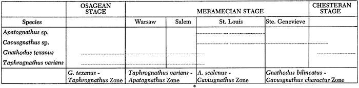
Thompson and Goebel (1968, p. 18) described Meramecian conodonts from the subsurface of Kansas and recorded a fauna similar to that described above in several cores. This fauna was said to identify the "lower part of the St. Louis Formation." Often, considerable overlap exists between the first (or lowest) appearance of Cavusgnathus and the last (or highest) appearance of Taphrognathus. Lineback (1972) demonstrated through cross sections in the subsurface of west-central Illinois that the lower part of the St. Louis Limestone in the region of the Mississippi River Valley is a lateral, fine-grained facies of the bioclastic upper Salem to the east (Lineback, 1972, p. 9, 16, and fig. 11). Thus, it is reasonable to consider that elsewhere in the type St. Louis region the zonal boundary between the T. varians-Apatognathus and A. scalenus-Cavusgnathus zones may more closely approximate the Salem-St. Louis formational boundary, this latter often being transitional.
Samples at 49 (basal shale of the Pennsylvanian) and 50-50.5 feet (15.2-15.4 m) yielded Neognathodus columbiensis (Stibane, 1967) and Idiognathodus delicatus Gunnell that are indicative of a Pennsylvanian age. The stratigraphic identity of this unit is in doubt, but it correlates with strata in west-central Missouri from which Thompson (manuscript in press) has recovered similar conodonts. These strata have been identified as shales and sandstones of the Riverton Formation and appear to be Atokan (possibly early Atokan) in age. In Missouri the Riverton is classified as Atokan in age. A Riverton identification for the shales in the #1 Velie Swalley core seems reasonable in that the type section for the Riverton Formation (NE NE sec. 22, T. 34 S., R. 24 E.) is approximately 4 miles (6.4 km) northeast of the core site. Moore, Frye, and Jewett (1944) showed Riverton (classified as Cherokee) resting on Mississippian beds (Keokuk-Warsaw) in Cherokee County, Kansas.
The age of the limestone portion of the #1 Velie Swalley core, based on conodonts (Fig. 4), is middle Meramecian. This age would correlate with the "lower St. Louis Limestone" of Thompson and Goebel (1968), and is herein regarded as probably corresponding to the Salem-St. Louis boundary sequence. Data based upon endothyrid and tournayellid foraminifers indicate a Meramecian (Salem) and early Chesteran age (Fig. 2) for the limestone. The age of the black shale is not Desmoinesian (Cherokee), as previously supposed, but seemingly is Atokan (or Morrowan) (Wilson, L. R., personal communication, February 1977).
Outcrops from which Thompson and Goebel collected samples yielding conodonts of late Osagean (Keokuk) age lie at a topographic elevation of approximately 900 feet (274.3 m) (see Fig. 5). Eight miles (12.9 km) to the west, the surface elevation of the #1 Swalley is 849 feet (258.8 m), and core 76 feet below the surface is still in Meramecian beds. Stratigraphically, the top of the Osagean must lie beneath these Meramecian beds. In a nearby well, the Bearsley #10 Bailey, sec. 10, T. 35 S., R. 24 W., 3.5 miles (5.6 km) southwest of Baxter Springs, "Short creek oolite" (commonly used as a marker bed for top of Keokuk in this area) was logged at 145 feet (44.1m) below the surface. Since the dip on Mississippian beds, which is about 15-20 feet per mile (or 4.6-6.1 m per 1.6 km maximum) (Siebenthal, 1915), is apparently too gentle to account for the difference in elevation between these two points, one is led to suspect that abnormal structural relationships in this area must account for this difference.
Figure 5--Map showing some structural relationships in southeastern Kansas and surrounding area, location of #1 Velie Swalley well, and area from which outcrop samples were collected by Thompson and Goebel. Keene's fault in the Roubidoux has not been traced to the surface, but it parallels in part the axis of the Miami trough. Note major faults trend NE-SW, with smaller structures nearly perpendicular to them. It is postulated that drainage in this area was controlled in part by structure (particularly fault trends), in both present and geologic time. (From Keene, in preparation; McKnight and Fischer, 1970; Thompson and Goebel, 1968; Geologic Map of Missouri, 1961; Geologic Map of Oklahoma, 1954; Pierce and Courtier, 1937 [1938]).
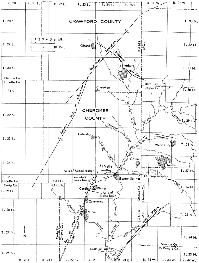
Paleontological evidence supports the inference that one or more faults, or some sort of structure, must lie between the Keokuk outcrops on the eastern border of Kansas and the area of the #1 Velie Swalley west of Baxter Springs. Earlier workers have shown that the structural axis of the Miami trough (or graben) passes through this vicinity (see sources in Fig. 5). At one point along the Miami graben, Pennsylvanian shales are displaced nearly 350 feet (106.7 m) (Brockie, Hare and Dingess, 1968). Drill holes that penetrated the Precambrian igneous complex at the northern end of Picher Field show that the graben structure extends into the Precambrian rocks. McKnight (McKnight and Fischer, 1970) believes that these alignments "represent breaks in the Precambrian basement . . . along which ore solutions arose." The presence of the Seneca fault graben (Fig. 5) has been documented by McKnight and Fischer (1970). The Picher anticline (new), named by Brockie, Hare and Dingess (1968), extends in a northwesterly direction from the eastern part of Ottawa County, Oklahoma, through Picher Field. It is interrupted by the Miami trough. Structure maps on the top of the Short Creek oolite and on the Cotter Dolomite reflect the presence of the Picher anticline at depth. The Ritchey fault extends from Monett, Missouri, almost due west beyond Ritchey (Newton County), Missouri, for a total distance of about 25 miles (40.2 km), with a maximum displacement of at least 150 feet (45.7 m) (Brockie, Hare and Dingess, 1968). Katherine Keene (personal communication, Feb. 1976) recently has mapped a fault (Fig. 5) in the subsurface Roubidoux Formation which trends N 23° E through Miami and Cardin, Oklahoma, to the Oklahoma-Kansas border, thence E 22° N to the vicinity of Baxter Springs, Kansas, and then N 30° E. The displacement on the top of the Arbuckle appears to be 50 to 200 feet (15.2 to 61.0 m). The #1 Swalley hole appears to lie on the western side of this major fault just west of Baxter Springs. Keene's fault parallels quite closely the Miami trough. A second fault in the subsurface Roubidoux Formation discovered by Keene starts in T. 29 N., R. 21 E. (Craig County, Oklahoma) and trends N 29° E, bifurcates at the Labette-Neosho county line in Kansas, heads N 37° E, crosses the Pittsburg anticline (Crawford County, Kansas), and heads on up to the vicinity of T. 33 N., R. 33 W. (Barton County, Missouri). There are, in addition to the Miami syncline and the Seneca graben, other structures and lateral and cross faults mapped in the Tri-State area (Fig. 5) (Smith and Siebenthal, 1907; Brockie, Hare and Dingess, 1968, fig. 1; McKnight and Fischer, 1970). Thus, the #1 Velie Swalley may lie in a small graben-like structure, or in a syncline, or in a sinkhole (Siebenthal, 1915) in the center of which younger beds are preserved. Willman, et al. (1975, p. 173) state that in Illinois "certain sinkhole or cave deposits lying on or in older carbonates in western and northeastern Illinois contain very early Pennsylvanian strata that have not been correlated with strata in other areas, although they are at present considered Morrowan."
Isolated remnants of Meramecian, Chesteran, and Morrowan-Atokan? beds discovered in this investigation indicate that Chesteran-Morrowan-Atokan seas once extended at least as far north as Cherokee County, Kansas. This study points out the probable existence of unknown faults and structural complications in this area and a need for further study in order to clarify regional stratigraphic and structural relationships in southeastern Kansas. The presence of such buried faults and structures has economic importance in that they have a bearing on the localization of metallic ores. It is strikingly apparent, upon examination of the positions of the faults and structures shown in Figure 5, that they influenced the existing drainage pattern in this part of the Tri-State area. Detailed palynological and paleontological work is needed to aid in unraveling the sedimentary history and age relationships of early Pennsylvanian coals and associated strata in this area.
We are grateful to D. C. Brockie, Chief Geologist, Eagle-Picher Industries, Inc., for assistance and for permission to publish results of research on the #1 Velie Swalley well core. Thanks are extended also to Wallace B. Howe, Director and State Geologist, Division of Geology and Land Survey, Missouri Department of Natural Resources, for review of the manuscript and permission to publish research results obtained by T. L. Thompson; to W. J. Ebanks, Jr. and M. O. Oros, Subsurface Geology Section, Kansas Geological Survey, to E. J. Zeller, Department of Geology, The University of Kansas, and to H. G. O'Connor, Groundwater Section, Kansas Geological Survey, for review of the manuscript and helpful suggestions; and to G. K. Reddy, who prepared the thin sections, and J. J. Jaeger, who drafted the line illustrations. Special thanks are due K. M. Keene, Groundwater Section, Kansas Geological Survey, for subsurface information from a study in preparation on aquifers in southeastern Kansas.
Abernathy, G. E., 1943, Deep Water Well at the Jayhawk Ordnance Works in Cherokee County, Kansas: Kansas Geol. Survey, Bull. 47, p. 77-112, 4 fig. [available online]
Bretz, J. H., 1965, Geomorphic History of the Ozarks of Missouri: Missouri Geol. Survey & Water Resources, v. 62, ser. 2, 147 p., 1 pl., 48 fig.
Brockie, D. C., Hare, E. H., Jr., and Dingess, P. R., 1968, The Geology and Ore Deposits of the Tri-State District of Missouri, Kansas, and Oklahoma; in Ridge, J. D., (Ed.), Ore Deposits of the United States, 1933-1967: New York, American Institute of Mining, Metallurgical, and Petroleum Engineers, Inc., p. 400-430.
Collinson, Charles, Rexroad, C. B., and Thompson, T. L., 1971, Conodont Zonation of the North American Mississippian; in, Symposium on Conodont Biostratigraphy, W.C. Sweet and S.M. Bergstrom, eds.: Geol. Soc. Amer. Mem. 127, p. 353-394.
Eardley, A. J., 1962, Structural Geology of North America: 743 p., Harper & Row, Publishers, New York and Evanston.
Ebanks, W. J. Jr., Euwer, R. M., and Nodine-Zeller, D. E., 1977, Geology of a Mississippian Combination Trap, Bindley Field, Hodgeman County, Kansas: Am. Assoc. Petrol. Geologists, Bull., v. 61, no. 3, p. 309-330, 35 fig.
Jewett, J. M., and Abernathy, G. E., 1945, Oil and Gas in Eastern Kansas: Kansas Geol. Survey, Bull. 57, 244 p., 4 pl., 21 fig., 91 tables.
Keene, K. M. (in preparation), Hydrogeology of the Arbuckle Group Artesian System in Southeastern Kansas: Kansas Geol. Survey publ.
Koenig, J. W., ed., 1961, The Stratigraphic Succession in Missouri: Missouri Geol. Survey & Water Resources, v. 60, ser. 2, 185 p., 1 pl., 132 fig., 4 tables.
Lee, Wallace, 1940, Subsurface Mississippian Rocks of Kansas: Kansas Geol. Survey Bull. 33, 114 p.
Lineback, J. A., 1972, Lateral Gradation of the Salem and St. Louis Limestones (Middle Mississippian) in Illinois: Illinois State Geol. Survey, Circular 474, 23 p., 11 fig.
McKnight, E. T., and Fischer, R. P., 1970, Geology and Ore Deposits of the Picher Field, Oklahoma and Kansas: U.S. Geol. Survey, Prof. Paper 588, 165 p., 11 pl., 45 fig., 10 tbl. [available online]
Moore, R. C., Frye, J. C., and Jewett, J. M., 1944, Tabular Description of Outcropping Rocks in Kansas: Kansas Geol. Survey, Bull. 52, Pt. 4, p. 137-212, 9 fig. [available online]
Nodine-Zeller, D. E., 1953, Endothyroid Foraminifera and Ancestral Fusulinids from the Type Chesteran (Upper Mississippian): Jour. Paleont., v. 27, no. 2, p. 183-199, pl. 26-28, 9 text-fig.
Nodine-Zeller, D. E., 1972, Endothyroid Foraminifera from Subsurface Mississippian in Kansas: Kansas Geol. Survey, Bull. 204, Pt. 1, p. 27-28, 2 fig. [available online]
Pierce, W. G., and Courtier, W. H., 1937 [1938], Geology and Coal Resources of the Southeastern Kansas Coal Field in Crawford, Cherokee, and Labette Counties: Kansas Geol. Survey, Bull. 24, 122 p., 13 fig., 12 pl.
Schopf, J. M., 1938, Spores from the Herrin (No. 6) Coal Bed in Illinois: Illinois State Geol. Survey, Rept. Invest. no. 50, 73 p., 8 pl., 2 fig.
Siebenthal, C. E., 1915, Origin of the Zinc and Lead Deposits of the Joplin Region, Missouri, Kansas, and Oklahoma: U.S. Geol. Survey, Bull. 606, 283 p., 11 pl., 16 fig.
Smith, W. S. T., and Siebenthal, C. E., 1907, Joplin District Folio, Missouri-Kansas: U.S. Geol. Survey, Geologic Atlas of the United States, Folio 148, 20 p.
Stibane, F. R., 1967, Conodonten des Karbons aus dem nordlichen Anden Südamerikas: Neues Jahrb., Geol. und Paläont. Abhandl., T. 128, nr. 3, p. 329-340, 3 pl.
Thompson, T. L., 1972, Conodont Biostratigraphy of Chesterian Strata in Southwestern Missouri: Missouri Geol. Survey, Rept. Invest. 50, 57 p., 1 pl.
Thompson, T. L., (in preparation), Conodont Biostratigraphy of Morrowan and Atokan (Lower Pennsylvanian) rocks of western Missouri.
Thompson, T. L. and Goebel, E. D., 1968, Conodonts and Stratigraphy of the Meramecian Stage (Upper Mississippian) in Kansas: Kansas Geol. Survey, Bull. 192, 56 p., 5 pl. [available online]
Willman, H. B., Atherton, Elwood, Buschback, T. C., Collinson, Charles, Frye, J. C., Hopkins, M. E., Lineback, J. A., and Simon, J. A., 1975, Handbook of Illinois Stratigraphy: Illinois State Geol. Survey, Bull. 95, 261 p., 176 fig., 3 tbl.
Winslow, M. R., 1959, Upper Mississippian and Pennsylvanian Megaspores and Other Plant Microfossils from Illinois: Illinois State Geol. Survey, Bull. 86, 135 p., 16 pl.
Zeller, D. E., ed., 1968, The Stratigraphic Succession in Kansas: Kansas Geol. Survey, Bull. 189, 81 p., 1 pl., 13 fig., 3 tbl. [available online]
Kansas Geological Survey, Geology
Placed on web Sept. 24, 2008; originally published in April 1977.
Comments to webadmin@kgs.ku.edu
The URL for this page is http://www.kgs.ku.edu/Publications/Bulletins/211_3/index.html