![]()
Prev Page--Introduction || Next Page--Descriptions, Research
Soil Landscapes
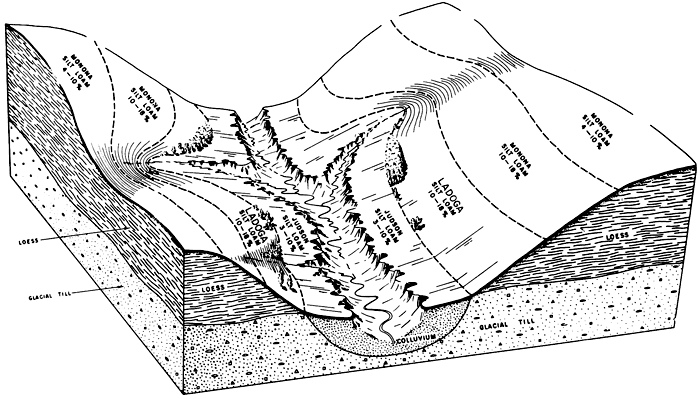
Each soil in Kansas occupies a logical and predictable part of the landscape. [Note: Terms included in the glossary are italicized the first time they occur, and are linked to the glossary.] Soil maps locate the local variabilities which the soil profile descriptions record. Regionally, within Kansas, landscapes differ as the traveler drives from one part of the state to another part. Photographs (Figures 1 and 2), diagrams, or cross sections are useful in showing some of these soil-landscape positions. In Brown County, for example, some soils are located on hills of glacial till, mantled by loess from wind deposits, with other soils formed in colluvium moved into the low spots and valleys by gravity and water. Figure 3 shows a typical soil landscape for this area. Ladoga and Monona soils formed in loess deposited by wind thousands of years ago; these soils are generally sloping. Judson soils, however, formed in colluvium moved more recently from the slopes by gravity and water; the Judson soils occupy the footslopes of valley walls. Obviously, Monona and Ladoga soils may have good homesites with aesthetic views of the valley, but Judson soils have a flooding hazard. All the soils have moderate or moderately slow permeability for septic tanks. Some places may be suitable for sewage lagoons, but careful investigations are necessary before lagoons are built.
Figure 1--View of rock outcrops. Rocky soils with bedrock outcrops are common in many parts of Kansas, as the soil maps indicate. Commonly the areas are not farmed or intensively developed, because the soils are poor for most uses, Although these areas are poor for waste disposal, they can be effectively used for aesthetic and recreational purposes--like hiking trails and picnic areas. Areas like this are common around many of the reservoirs in Kansas; their locations should be carefully considered in overall planning for location of septic tanks, sewer lines, and other types of land development.
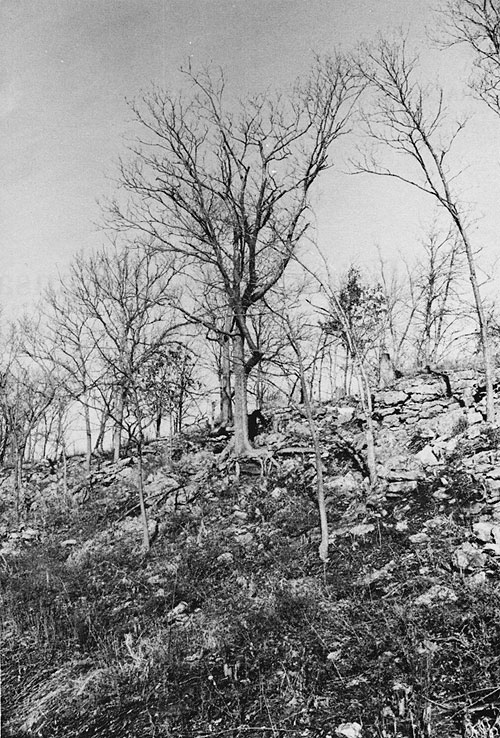
Figure 2--View of alluvial area. Soils in recent alluvium may be frequently, occasionally, or rarely flooded. These places may have severe limitations for waste disposal. In critical areas, like around lakes in Kansas, developments on these soils can be restricted to parks, recreation, and certain other uses which are not damaged as much by flooding as are buildings and some other structures.
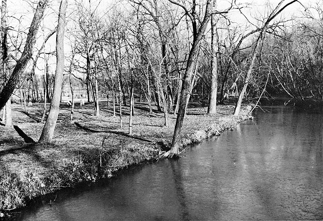
Figure 3--Typical cross section of soils of the strongly sloping loess hills in Brown County, Kansas (adapted from Eikleberry, 1960, page 2).
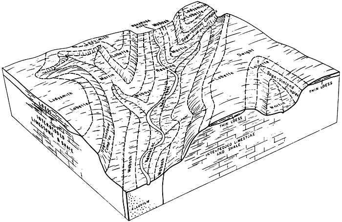
In contrast, some soil landscapes around Topeka in Shawnee County have more complex soil patterns. One of these landscapes is illustrated in Figure 4, taken from the soil survey report (Abmeyer and Campbell, 1970). In these places (Figure 4), Dwight soils occupy the tops of bills mantled by thin loess deposits over bedrock, and Ladysmith soils have developed in thicker loess deposits over bedrock. Obviously, Dwight soils have hazards for septic-tank seepage fields due to the proximity of the fissured limestone and shale, but both Dwight and Ladysmith soils have fine textures, very slow permeability for sewage effluent, and seasonally high apparent water tables. Water rises higher than 30 inches from the soil surface within Ladysmith soils during early spring of most years. Labette, Sogn, Vinland, and Martin soils have variable depths to bedrock, occupying the respective slopes shown in Figure 4; excavations in all these places in these soils will probably encounter bedrock at less than 40 inches, except in Martin soils where bedrock is deeper than 40 inches. In the valley bottoms, Kennebec, Reading, and Wabash soils have formed in alluvial sediments deposited by floodwaters. Without flood protection, these soils have flooding limitations for all kinds of waste disposal.
Figure 4--Soil relationships to surface deposits and bedrock in the southwestern part of Shawnee County, Kansas (adapted from Abmeyer and Campbell, 1970, page 5).
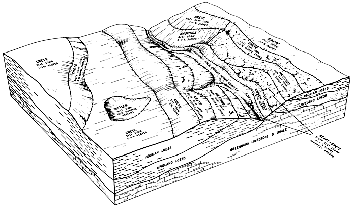
In Figure 5, another type of soil landscape of Kansas is illustrated. Some of these landscapes in Republic County (Atkinson and Gier, 1967) have Crete soils on variable slopes of the uplands. Crete soils have slow permeability for septic-tank seepage fields and have apparent water tables shallower than 30 inches during early spring in most years. Butler soils occupy the low spots where water tables are even higher; these places may be flooded after heavy rains in some years. Hastings, Crete, and Geary soils occupy slopes likely to be eroded in these landscapes. Hobbs soils are on the bottomlands and generally are not subject to erosion.
Figure 5--Soil landscape in loess of different depositions and Greenhorn limestone and shale in Republic County, Kansas (Adapted from Atkinson and Gier, 1967, page 3).
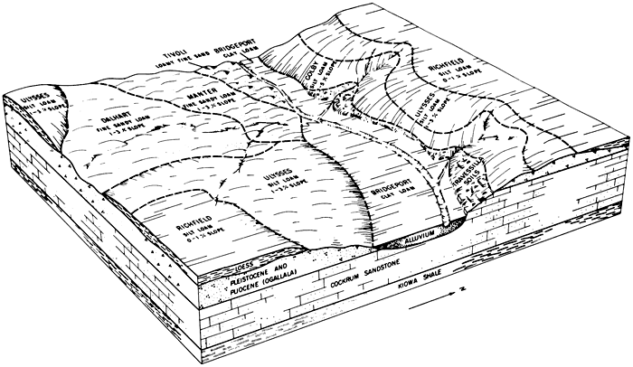
Landscapes in western Kansas are different, as Figure 6 illustrates. In Bear Creek valley in the southwestern part of the state, Richfield soils occupy nearly level loess uplands of 0 to 1 percent slopes; these areas are good for most kinds of waste disposal. Richfield soils are well drained, but have fine textures and moderately slow permeability. Ulysses soils are well drained and have moderate permeability on more sloping areas of loess over coarse outwash deposits. Dalhart soils have fine loamy textures and no limitations for any kind of waste disposal; they have excellent characteristics for septic tanks, sanitary landfill, and even sewage lagoons. Manter soils have shale at 40 to 60 inches. Tivoli soils on sand dunes have rapid permeability, but this causes a ground-water contamination hazard for waste disposal. Travessilla soils have sandstone at 10 to 20 inches on steep slopes; they are not very suitable for any kind of waste disposal. Valley bottoms have Bridgeport soils in fine silty alluvium; they are well drained and have moderate permeability, but are subject to flooding.
Figure 6--Landscape of soils in Bear Creek valley in Stanton County, Kansas (Adapted from Fleming et al., 1961, page 2).
Soil Maps
Current soil mapping in Kansas is done on aerial photographs at a scale of four inches to one mile, and published at a scale of 1:20,000 (one unit on the map represents 20,000 units on the soil surface), 1:24,000, or 1:31,680. About half of the state of Kansas has been mapped at the four inch to one mile scale, and about one-fourth of the area of the state has published soil maps available at the 1:20,000 or smaller scales. Published soil maps are available for counties including Brown, Finney, Ford, Geary, Grant, Gray, Greeley, Hamilton, Harper, Haskell, Kearny, Lane, Loran, Morton, Pratt, Reno, Republic, Saline, Scott, Seward, Shawnee, Stanton, Stevens, and Wichita. In 1972, a typical year, about 30 full-time soil scientists were engaged in the field mapping of soils in Kansas. In the past 20 years, millions of dollars have been invested in Kansas in this resource inventory of soils, one of the most valuable natural resources. Much of the mapping is scattered and unpublished, but the field maps on the aerial photographs can be consulted in district offices of the Soil Conservation Service, one of which is located in most of the counties in Kansas.
In effect, soil maps are an on-site inventory of soil resources, in which the soil scientist has mapped several hundred acres each day. He has dug holes in surface soils and subsoils, measured slopes, observed vegetation, and recorded everything that might affect use of the soils for septic tanks, sewage lagoons, sanitary landfill, and other uses. Holes are dug in every delineated area or soil map unit, and each significant soil variation is shown on the map down to areas as small as an acre or several acres in size. Accuracy of the maps may be considered to be at least 80-90 percent for most uses; the information to be derived from a soil map depends somewhat upon the skill and experience of the user of the map and his knowledge of soils, geomorphology, and other earth sciences. Each soil of an area is described and mapped with respect to:
- Land form, relief, drainage
- Parent material of soils, geology
- The soil profile in vertical section
- Color
- Texture
- Structure
- Porosity
- Consistence
- Acidity, alkalinity, lime status
- Concretions, other special formations
- Organic matter, roots
- Chemical and mineralogical composition
- Other characteristics
- Stoniness
- Erosion
- Vegetation
- Land use
- Other significant factors
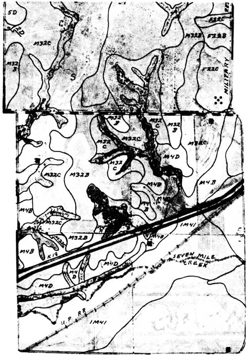
Figure 7 gives an example of a soil survey field sheet, taken from a leaflet on planning for proper land use in Kansas (Soil Survey Staff, 1972a). The soil map shows areas that have steep slopes (5D), areas that are flooded (IM41), areas that have high seasonal water tables (IM4 in legend, not labeled on map), areas that have slow permeability (F22C), and areas that have few or no significant limitations for waste disposal in septic tanks (M4B). Similarly, all areas of Kansas that have soil maps can be rated for waste disposal and for soil properties that favor or restrict various methods of disposal of liquid and solid wastes.
Figure 7--Reproduction of portion of unpublished soil map from area in Riley County, Kansas (Adapted from Soil Survey Staff, 1972a). Top of map is north.
Prev Page--Introduction || Next Page--Descriptions, Research
Kansas Geological Survey, Geology
Placed on web Aug. 7, 2009; originally published March 1974.
Comments to webadmin@kgs.ku.edu
The URL for this page is http://www.kgs.ku.edu/Publications/Bulletins/208/02_land.html