![]()
Prev Page--Regional Structure || Next Page--Subsurface stratigraphy
Stratigraphy
General
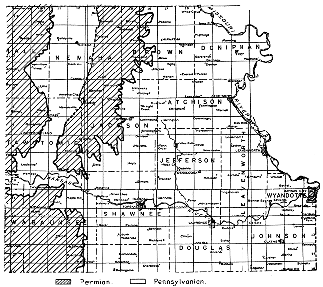
The surface formations of northeastern Kansas are Quaternary deposits, and Permian and Pennsylvanian strata. The unconsolidated Quaternary materials. consist of Pleistocene glacial deposits, loess and alluvium. In the northern counties, especially Nemaha, Brown, Doniphan and western Atchison, Pleistocene glacial deposits and loess cover most of the bedrock so that exposures of the underlying Permian and Pennsylvanian rocks are scarce. Figure 4 shows the Permian and Pennsylvanian boundaries in northeastern Kansas.
Figure 4--Distribution of Pennsylvanian rocks in northeastern Kansas.
Formations known to be present but not exposed are of Lower Pennsylvanian, Mississippian, Siluro-Devonian, Cambro-Ordovician and pre-Cambrian age. The pre-Pennsylvanian beds described in this report will be given names according to the Iowa classification because they can be traced by log correlation to the outcrop in Iowa. The Forest City Basin in Kansas is but the south extension of a large basin occurring in southwest Iowa and northeast Missouri. The lithologic and stratigraphic data relative to the correlation of the Kansas and Iowa beds will be given in the following discussions of the pre-Pennsylvanian systems.
Surface Stratigraphy
Quaternary deposits
The unconsolidated deposits occurring in northeastern Kansas are glacial drift, loess, lake deposits and alluvium. The glacial deposits of Pleistocene age are confined to the northeastern part of the state. Todd states: "Northeastern Kansas, including the area bounded on the east, south and west by the Missouri, Kansas, and Big Blue rivers, respectively, was invaded by the second, or Kansan, continental ice sheet." (Schoewe, W. H.: Glacial geology of Kansas. Pan-American Geologist, vol. XL, pp. 102-110, Sept., 1923.) Additional work by Schoewe has resulted in the relocation of the boundary of the Kansan drift area several miles south of the Kansas river." (Schoewe, W. H.: Evidence for a. relocation of the drift border in eastern Kansas: Jour. Geology, vol. XXXVIII, No. 1, pp. 67-74, 1930.) The first, or Nebraskan drift, is thought to be present in Nebraska, but has not been identified in Kansas as yet (Schoewe, W. H.: Personal communication). The Kansan drift is composed of till, sand, gravel and erratic boulders. Associated with the drift are thick deposits of loess scattered over the northeastern counties of Kansas. The loess is a fine yellowish clay-like deposit which ranges up to 100 feet in thickness. Lake deposits consisting of fine sands and clays are found in northeastern Kansas. Kaw Lake was formed by the damming of the Kansas river, and occupied the area between Manhattan, in Riley County, and Wamego, in Pottawatomie County. Sands 100 feet thick, many erratic boulders and lacustrine silts and clays characterize the lake deposits. In the vicinity of Atchison, in Atchison County, is a succession of fine sands and silts averaging 30 feet, which were probably also deposited in a temporary lake created by ice damming. Alluvium of recent age is found in the valleys of the main streams. The alluvium consists of sands, silts, and gravels. The masking of the bedrock by the Quaternary deposits and the consequent difficulty in locating structures favorable to the accumulation of oil and gas has been one of the important factors retarding the exploitation of oil and gas in this area.
Permian
Figure 4 shows the area of Permian bedrock in northeastern Kansas. The Permian strata belong to the Council Grove and Chase groups of the Big Blue series. They are of marine origin and are shales and limestones for the most part. The important limestones of the Council Grove group are the Americus, Neva and Cottonwood. The Chase group is characterized by limestones and hard, resistant chert. The chert and limestone beds form prominent escarpments where exposed. The important ledge-forming beds are the Wreford limestone, Florence flint, Fort Riley limestone and Winfield limestone.
Pennsylvanian
With the exception of the Marmaton and Cherokee, all of the Pennsylvanian groups outcrop in the area covered by this report. Figure 4 shows the general distribution of the Pennsylvanian formations in northeastern Kansas. The oldest of the exposed rocks belong to the Missouri series, which, as redefined by Moore, extends from the important unconformity below the Sniabar ("Hertha") limestone to another widely recognized unconformity above the Stanton limestone, or locally the Iatan limestone. The Lansing, Kansas City and Bronson groups outcrop in Johnson and Wyandotte counties and in southern Leavenworth and northeastern Douglas counties. The Douglas group outcrops over much of Douglas and Leavenworth counties, southern Jefferson County, and the eastern edge of Atchison and Doniphan counties. The Shawnee group occupies a belt extending through eastern Shawnee County, western Douglas County, and most of Jefferson, Atchison and Doniphan counties. The upper Shawnee beds are found in eastern Jackson and Brown counties. The Wabaunsee group occupies most of eastern Wabaunsee, Jackson and eastern Brown counties, and western Shawnee and Atchison counties. The lithology and thickness of the Pennsylvanian beds will be described in the section on subsurface stratigraphy.
| Series | Group | Formation |
|---|---|---|
| Virgil | Wabaunsee | Admire shale* Brownville limestone Pony Creek shale Caneyville limestone French Creek sbale Jim Creek limestone Friedrich shale Grandhaven limestone Dry shale Dover limestone Table Creek shale Maple Hill limestone Pierson Point shale Tarkio limestone Willard shale Elmont limestone Harveyville shale Reading limestone Auburn shale Wakarusa limestone Soldier Creek shale Burlingame limestone Silver Lake shale Rulo limestone Cedar Vale shale Happy Hollow limestone White Cloud shale Howard limestone Severy shale |
| Shawnee | Topeka limestone Calhoun shale Deer Creek limestone Tecumseh shale Lecompton limestone Kanwaka shale Oread limestone |
|
| Douglas | Lawrence shale Haskell limestone Stranger formation |
|
| Unconformity | ||
| Missouri | Pedee | Iatan limestone Weston shale |
| Lansing | Stanton limestone Vilas shale Plattsburg limestone |
|
| Kansas City | Bonner Springs shale Wyandotte limestone Lane shale Iola limestone Chanute shale Drum limestone Cherryvale shale |
|
| Bronson | Dennis limestone Galesburg shale Swope limestone Ladore shale Hertha limestone |
|
| Bourbon | Undifferentiated shale and limestone "Uniontown" limestone Unnamed shale Warrensburg channel sandstone |
|
| Unconformity | ||
| Des Moines | Marmaton | Lenapah limestone Nowata shale Altamont limestone Bandera shale Pawnee limestone Labette shale Fort Scott limestone |
| Cherokee | Cherokee shale | |
| Unconformity | ||
| * Now included in Big Blue series | ||
Prev Page--Regional Structure || Next Page--Subsurface stratigraphy
Kansas Geological Survey, Geology
Placed on web Jan. 27, 2014; originally published May 1935.
Comments to webadmin@kgs.ku.edu
The URL for this page is http://www.kgs.ku.edu/Publications/Bulletins/20/03_surf.html