![]()
Prev Page--Contents || Next Page--Surface stratigraphy
Regional Structure
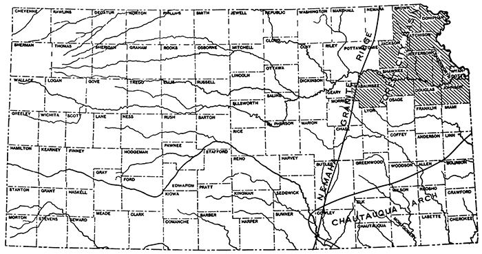
Three major structures are found in eastern Kansas and are known as the Forest City Basin, the Nemaha Granite Ridge, and the Chautauqua Arch. Figure 1 shows the relative positions of these structural features. The counties discussed in this report are also indicated in figure 1 and it will be noted that they lie principally in the Forest City Basin.
Figure 1--Index map and structural features of eastern Kansas.
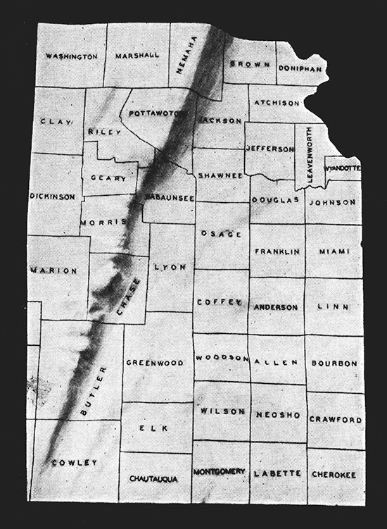
The Forest City Basin lies in the extreme northeastern part of Kansas and extends northeastward into Missouri. The basin was named after Forest City, Missouri, where a deep well was drilled in 1901. The correlation of this well, as given by Ulrich, indicated that there is a basin, and subsequent drilling in Kansas has fairly well defined the boundaries and outline of the southern end of the basin in eastern Kansas (Hinds, Henry, and Greene, F. C.: The stratigraphy of the Pennsylvanian series in Missouri. Missouri Bur. Geology and Mines, vol. XIII, 2d ser., pp. 215-239, 1914). The general outline of the basin is marked by the distribution of the Hunton "lime" east of the Granite Ridge (Fig. 2). Figure 3, a reproduction of a relief model of the Nemaha Granite Ridge, reveals the general character of the basin. The Granite Ridge rises abruptly on the western side of the basin and the Chautauqua Arch rises more gradually on the southern and southeastern sides.
Figure 2--Areal distribution of pre-Mississippian in Kansas. From McClellan, Hugh W., Subsurface distribution of pre-Mississippian rocks of Kansas and Oklahoma; Am. Assoc. Petroleum Geologists, Bull., vol. 14, No. 12, pp. 1535-1556, Dec., 1930. Reprinted by courtesy of the American Association of Petroleum Geologists by whom the map is copyrighted.
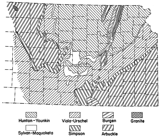
Figure 3--Photograph of relief model of Nemaha granite ridge.
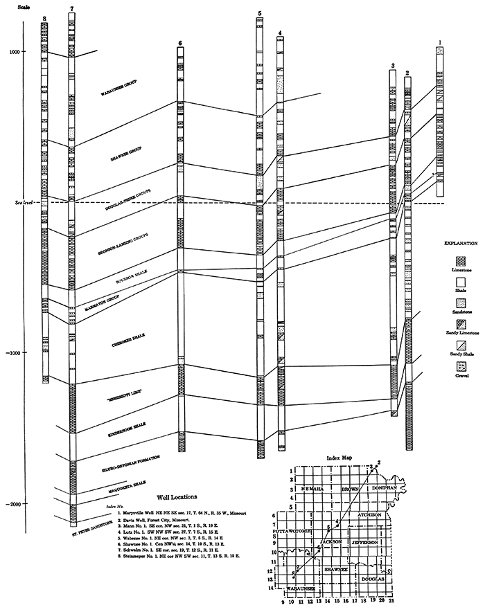
Plates I and II give a picture of the basin and the formations that are found in it. The section of the Empire Oil and Gas Company's No. 1 Schwalm well in the SE cor. sec. 19, T, 12 S., R. 11 E., Wabaunsee county, is typical of the pre-Pennsylvanian geologic sequence in the basin. The following beds are recorded:
| Thickness in feet |
||
|---|---|---|
| Mississippian System: | ||
| "Missippi lime" | 320 | |
| Kinderhook shale | 185 | |
| Devonian and Silurian Systems: | ||
| Limestone | 222 | |
| Ordovician System: | ||
| Maquoketa shale | 70 | |
| Galena-Platteville limestone | 112 | |
| St. Peter sandstone | 31+† | |
| †Well was drilled 31 feet into St. Peter sandstone and abandoned. | ||
Plate I--East-west cross section through Forest City Basin, northeastern Kansas. [An Acrobat PDF version of this figure is available (1.8 MB).]
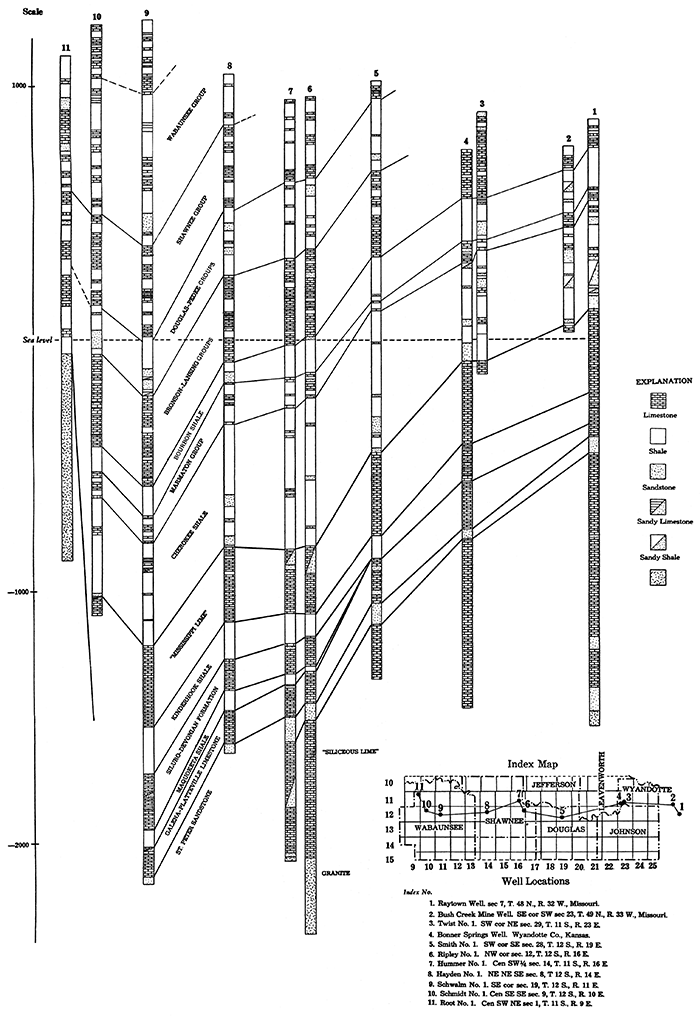
Plate II--North-south cross-section through Forest City Basin, northeastern Kansas. [An Acrobat PDF version of this figure is available (1.3 MB).]
The Nemaha Granite Ridge comprises the western border of the Forest City Basin in Kansas. The ridge extends from near Omaha, Nebraska, across Kansas between Nemaha county and eastern Sumner county, trending about N. 18° E., to Oklahoma City, Oklahoma. The top of the granite is about 500 feet below the surface in Nemaha county and about 3,000 feet deep in Sumner county. A model showing the form of the Granite Ridge in Kansas, according to a map prepared by Dr. R. C. Moore, is shown in figure 3. It illustrates very well the position and magnitude of this feature.
The Chautauqua Arch is a part of the large uplift known as the Chautauqua-Barton Arch. The Chautauqua Arch is the pre-Mississippian extension of the Ozark uplift in southeastern Kansas and is separated from the Barton Arch to the northwest by a gentle saddle. The crest of the arch contains Arbuckle limestone unconformably overlain by Mississippian and (locally) by Pennsylvanian rocks. It is evident that the other pre-Mississippian formations were either never deposited along the axis of the Chautauqua Arch or if they were once present they were eroded prior to deposition of the Mississippian beds. Figure 2 shows the relationship of this arch to the Forest City Basin and the distribution of the early formations on the crest and flanks of the arch.
Prev Page--Contents || Next Page--Surface stratigraphy
Kansas Geological Survey, Geology
Placed on web Jan. 27, 2014; originally published May 1935.
Comments to webadmin@kgs.ku.edu
The URL for this page is http://www.kgs.ku.edu/Publications/Bulletins/20/02_regi.html