Kansas Geological Survey, Bulletin 199, Part 4, originally published in 1970
A PDF version is available
Originally published in 1970 as Kansas Geological Survey Bulletin 199, Part 4. This is, in general, the original text as published. The information has not been updated.
The Riley County, Kansas, kimberlites are thought to have been emplaced under explosive conditions resulting from abrupt tectonic activity about 120 ± 20 m.y. ago. Geometric and theoretical considerations indicate the kimberlites may have reached, or very nearly reached, the land surface. The velocity of the volatile-rich kimberlitic fluid may have reached 400 m/sec during final emplacement at a temperature range of 100° to 150°C as interpreted from comparative data for the Moses Rock, Utah, kimberlite. Low temperatures accompanying emplacement are also indicated by pre-emplacement K-Ar dates on chloritized phlogopites, fission track dates on apatites from xenoliths, and lack of pyrometamorphic contact effects.
It is proposed that the kimberlites crystallized in the upper mantle in the late Precambrian(?) at a minimum depth of 120 km and perhaps as deep as 300 km. This proposal is based on stability conditions necessary for the existence of ilmenite-pyroxene intergrowths found at the Stockdale kimberlite. The kimberlites were injected through the upper mantle-lower crust at high velocities and under near-adiabatic conditions and may have passed through a water-rich, low P-wave velocity zone. Ascent in the crust, especially in the last 1 km or so, occurred at an even higher velocity with little capture of the upper Precambrian basement rocks (arkoses, basalts, granitic rocks) until the pressure drop became significant as the surface was approached and many accidental xenoliths of Paleozoic sedimentary rocks were entrapped as the duct widened. The existence of several generations of kink bands in chloritized phlogopites indicates that emplacement from original reservoir to final site was not continuous but occurred sporadically until the mid- to upper crust was reached.
The six known kimberlites from Riley County, Kansas, have been described in some detail by Brookins (1970a, 1970b). One of the six, the Winkler kimberlite, had just been discovered and information concerning it was incomplete. Possible factors controlling their emplacement have been only briefly discussed.
It is the purpose of this report to describe the geometries of the kimberlites and the abundance and types of xenoliths found in them, and to compare existing geochemical and geophysical data for the Riley County kimberlites with similar data for the Moses Rock kimberlite (Utah), for which plausible hydrodynamic models have been proposed and evaluated by McGetchin (1968), Ullrich (1969), and McGetchin and Ullrich [McGetchin, T.R., and Ullrich, G.W., Deep-seated xenoliths: Observed terrestrial abundance, distribution, and emplacement in some maar and diatremes with inferences for the Moon, Mars, and Venus (preprint submitted for publication)]. In addition, the possibility of crater (maar) formation by gaseous explosion will be explored in view of the Palanquin nuclear blast described by Hansen (1968). Previously unpublished structural data for the Winkler and Randolph No. 2 kimberlites will be used to help in the interpretation.
Finally, new data pertinent to determining the depth in the mantle at which the kimberlites and their cognate ultrabasic nodules formed will be presented using the data reported by Ringwood and Lovering (1970), Dawson and Reid (1970), and Woods (1970).
Partial financial support for this study was provided by the Research Corporation, New York, and the Kansas Geological Survey. Discussions with Drs. H. O. A. Meyer (N.A.S.A., Goddard Space Flight Center), T. R. McGetchin (Massachusetts Institute of Technology), and Mr. M. J. Woods (Ulster College, Ulster, New York) have been helpful.
The Riley County kimberlites intrude Lower Permian sedimentary rocks but are thought to be post-uppermost Lower Cretaceous because two pronounced joint sets found in the Permian and Cretaceous rocks in Riley County are absent in the kimberlites, whereas at least two younger sets are found in the kimberlites, as well as in the Permian and Cretaceous rocks, and cut the above mentioned two well-developed sets. The kimberlites are not in direct contact with the Cretaceous rocks (Dakota sandstone), however, and this evidence is indirect. If correct, it places an absolute age of approximately 120 ± 20 m.y. on the age of emplacement.
Recently Brookins and Naeser (manuscript in preparation) have studied the problem in more detail by K-Ar and fission-track dating and conclude that the last cooling of granitic xenoliths in the Bala and Stockdale kimberlites occurred about 120 ± 10 m.y. ago based on fission-track dates on apatites at a temperature above 70°C and below 150°C. K-Ar dates on all kimberlitic chloritized phlogopites are near or significantly older than 200 m.y. which may be due to their xenocrystalline nature, an original high PAr in the kimberlites, or absorption of Ar by chlorites. (Note: the 95 ± 10 m.y. date for W-1, chloritized phlogopite from the Winkler kimberlite, reported by Brookins, 1970b, Table 5, should be 195 ± 10 m.y. as a result of erroneous reporting of data by Geochron Laboratories.) A K-Ar date on chloritized biotite from a granitic xenolith (Brookins, 1970b, Table 5, SI-1) is 112 ± 6 m.y. and is thought to be more accurate for dating purposes than the chloritized phlogopites because it contains more K (1.38 percent) than the former (0.08 to 0.5 percent K). Brookins (1969b) has used the K-Ar data for some of the chlorites to estimate a maximum temperature of emplacement of 150° ± 50°C for the kimberlites (to be discussed later) based on available diffusion data.
The proposed 120 ± 10 m.y. age of emplacement for the kimberlites (Brookins and Naeser, manuscript in preparation) is consistent with their geologic setting. The proposed low temperatures of emplacement are consistent with observed lack of pyrometamorphic contact effects and the hydrodynamic models (discussed later in this report).
The original age of formation of the kimberlites is not accurately known, although Brookins (1969c) has dated a composite pyrope sample from the Stockdale kimberlite by the Rb-Sr method at 745 ± 100 m.y. assuming initial Sr (87/86) = 0.702 and closed-system conditions since that time. This date is considered a minimum for age of original formation because of the possibility of Sr-87 loss by diffusion. Excess Sr-87 (i.e., age too high) due to post-formational events is unlikely due to the high resistance of pyrope to recrystallization.
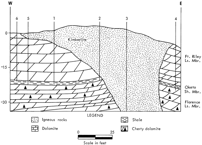
Magnetometer surveys by Dreyer (1947), Cook (1955), Dowell (1964), and Brookins (1970a) have shown that the Riley County kimberlites are pipe-like bodies that dip steeply to the east-southeast and are magnetically oriented approximately normal to the Abilene anticline. The data further indicate that all (except Winkler) may possess mushroom-like caps caused by lateral spreading near final sites of emplacement. Evidence of forceful injection of the kimberlites is present at Randolph No. 1 where the host Cresswell Limestone Member is strongly upbent at the contact with dips of 20° to 30° away from the kimberlite contact. Dips become nearly horizontal within a few feet of the contact (see Byrne, Parish, and Crumpton, 1956; and Fig. 1). Mapping of the Randolph No. 2 kimberlite reveals an elliptical surface outcrop (Fig. 2) which drilling has revealed to be a mushroom-like cap (Fig. 3) over a narrow feeder pipe. The beds of the host Fort Riley Limestone Member also dip away from the kimberlite (Fig. 3) and samples of pre-kimberlite weathered limestone recovered from some of the drill holes below the cap may indicate that the kimberlite very nearly reached the surface. This last information is in agreement with Merriam's (1963) interpretation that the Cretaceous cover over the Paleozoic rocks in the area was either very thin or even absent at places. The poorly exposed outcrops of the Stockdale (Rosa and Brookins, 1966), Leonardville (Dyer, 1970), and Bala (Dreyer, 1947) kimberlites reveal little information about contacts. However, a local fault contact may be present at Stockdale (Rosa and Brookins, 1966).
Figure 1--Geologic map of Randolph No. 1 kimberlite, SW NW sec. 35, T. 6 S., R. 6 E., Riley County, Kansas (mapping by V. J. McDermott, 1966).
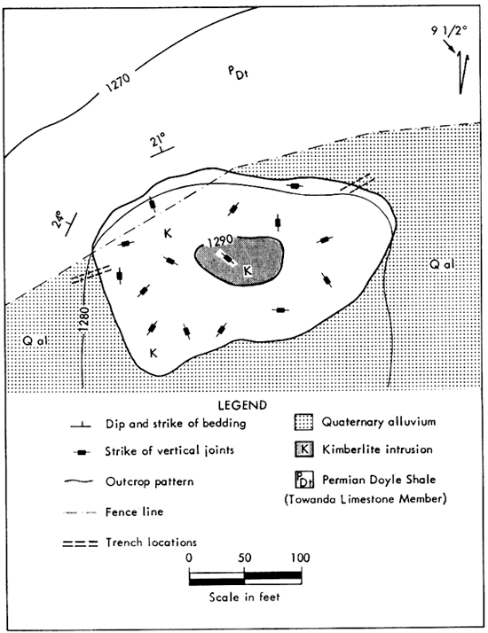
Figure 2--Geologic map of Randolph No. 2 kimberlite, SW SE sec. 35, T. 6 S., R. 6 E., Riley County Kansas (mapping by V. J. McDermott, 1966).
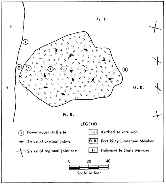
Figure 3--Generalized cross section of Randolph No. 2 kimberlite (cross section by V. J. McDermott).
The most striking surface geometry is exhibited by the Winkler kimberlite which shows on aerial photographs as a near-perfect circle and, due to this circularity, was thought to be due to meteoritic impact (discredited by Brookins, 1970a). Drilling by Brookins (1970a) in May, 1969, over a magnetic anomaly similar (although of lesser magnitude) to anomalies over the other five kimberlites revealed the presence of a typical assemblage of kimberlite minerals and rock fragments mixed with sedimentary rock fragments, gouge, and gypsum. Resistant limestones (Schroyer and Threemile limestones) used as marker beds in the area were not encountered in this hole (hole A, fig. 2a in Brookins, 1970a). Bedded limestone (Schroyer Limestone Member?) was reported from drilling carried out as student projects (holes B and C, fig. 2a in Brookins, 1970a), but the cuttings from these holes were evidently not saved or have been lost. No detailed mineralogic studies of the cuttings from holes B and C were attempted. More recent drilling was carried out in May and June, 1970. Hole A was continued to a depth of 200 feet, five additional holes were drilled on an east-west line through the position of hole A, and one hole (I) was drilled north of this line. The locations of these holes are shown in Figure 4. The normal stratigraphic sequence encountered in northern Riley County is presented in Table 1, and the preliminary drill-hole information is presented in Table 2. Kimberlitic material has been recovered from every hole drilled except B and C and no bedded limestones were encountered. Holes A, D, E, F, G, H, and I consist of shale-rich, kimberlite-poor, gouge-bearing, partially brecciated sequences with occasional nodules and fragments of limestone and/or magnetite-bearing carbonate rocks (carbonatitic?), occasional zones of gypsum, and zones of pronounced water flow. No bedded limestones are observed; shale-rich zones also do not appear to be well bedded but this is difficult to evaluate from auger drill-hole cuttings.
Figure 4--Topographic map of Winkler kimberlite, NE NW sec. 36, T. 6 S., R. 5 E., Riley County, Kansas, showing drill-hole locations (approximate maar outline indicated by circle).
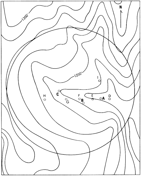
Table 1--Generalized partial stratigraphic sequence in north-central Riley County. [After Merryman (1957); terminology according to Zeller (1968).
| Formation | Member | Thickness, feet |
Remarks |
|---|---|---|---|
| Barneston Limestone | Florence Limestone | 27 | Cherty, resistant |
| Matfield Shale | Blue Springs Shale | 22 | Varicolored shale |
| Kinney Limestone | 2 | Soft, massive, tan-gray | |
| Wymore Shale | 35-40 | Varicolored, blocky | |
| Wreford Limestone | Schroyer Limestone | 6 | Massive, cherty |
| Havensville Shale | 8 | Gray shale | |
| Threemile Limestone | 6 | Massive, cherty | |
| Speiser Shale | 18 | Varicolored, limestone lenses | |
| Funston Limestone | 5 | Three limestones divided by gray shales |
|
| Blue Rapids Shale | 20 | Varicolored to green and maroon shale |
|
| Crouse Limestone | 7 | Tan-gray, platy to massive |
Table 2--Preliminary drill-hole data for the Winkler kimberlite. Based only on hand lens examination except for the 0-100 interval in hole A (Brookins, 1970a). KRF = kimberlite mineral and/or rock fragments; SRF = sedimentary rock fragments, usually shale; Lst = limestone (classified as nodules if rounded, fragments if angular); Gy = gypsum; W = water (flow estimated at 4 gal/minute). († Data not verified.)
| Drill hole |
Remarks (depths in feet below surface) |
|---|---|
| A | KRF previously noted In 17-21, 32-38, 47-55, 62-70, 78-85, 90-96 depth intervals (Brookins, 1970a); new data: KRF common from 120 to 220 depth interval although mixed with SRF, gouge, Gy (local) throughout. W at 50 and 60. Bottom at 220 feet. |
| B† | Limestone reported at 37 feet. Bottom at 50 feet. |
| C† | Limestone reported at 40 feet. Bottom at 50 feet. |
| D | KRF noted at 20-22, 55-70, 120-125 depths; Lst nodules noted at 37, 80, 85, 115 depths. Gy at 110-115 depth. SRF present throughout entire depth. W at 55. Bottom at 142 feet. |
| E | KRF at 45, 100-160 depths mixed with SRF; Lst fragments at 52, 65, 70, 92. W at 90. Bottom at 160 feet. |
| F | KRF at 70-80, 100-120; Lst nodules at 35, 85. Gy at 52, 60, 70. W at 77. Bottom at 120 feet. |
| G | KRF at 60-70, 93, 100-105; Lst nodules and/or fragments at 18, 24, 90, 105. Gy at 76, 104, 112. W at 100. Bottom at 120 feet. |
| H | KRF at 75, 90-100; Lst fragments at 35, 50, 80. Gy at 70, 80. W at 105. Bottom at 120 feet. |
| I | KRF at 40, 45-47, 64-70; Lst nodules at 50, 55. Gy at 46, 60. W at 35, 50. Bottom at 80 feet. |
It would be extremely difficult to miss either the Schroyer or Threemile limestones as both are massive, cherty limestones which are quite resistant to weathering and, as mentioned above, are used as marker beds throughout the general area. I can only conclude at this point that the interpretation of "bedded limestones" from holes B and C (unpublished student reports, Kansas State University) is erroneous and that the material encountered was actually small nodular limestone fragments which are found sporadically in all of the holes.
Based on the new information, the Winkler kimberlite is now interpreted as a typical maar-type eruptive resulting from emplacement of explosive, adiabatically cooled kimberlitic fluid which may have reached the surface. Post-kimberlite fluvial (and glacial?) action has largely obscured the surrounding terrain so that possible ejecta from the maar have not been found. An alternate explanation is that the kimberlite did not quite reach the surface but that the explosive mechanism weakened the overlying rocks by arching, and subsequent collapse coupled with increased, structurally induced dissolution of limestones occurred. Gas scouring as an erosional aid may have been active if the former hypothesis is correct (Hansen, 1968), but it is thought to be of lesser importance than the main explosive mechanism--rapid release of volatile-rich kimberlitic fluid from a deep-seated source due to abrupt tectonic activity (to be discussed later in this report).
Of additional interest is the reporting of pyrope from water-well cuttings approximately one-half mile west of the Winkler kimberlite (C. E. Pfaff, personal communication) which may indicate the presence of another kimberlite or an apophysitic sill of the Winkler kimberlite.
Because of excessive cover, proximity to the axis of the Abilene anticline, and slumping, it is difficult to explore the surrounding country rocks at the Winkler kimberlite for dips away from the "contact." Small apparent tear faults a few feet in length, similar to tear faults reported at Randolph No. 2 by Byrne, et al. (1956), are noted in a few places oriented normal to the "crater," but their origin is not necessarily due to, although suggested by, the kimberlitic emplacement.
It is significant that at least one (Winkler) maar-type structure has been found among the Riley County kimberlites. This substantiates McGetchin's (1968) idea that maars are to be expected over kimberlitic dike systems where there is a thin cover of overlying rocks. In Riley County it is not clear whether or not there is a major dike system of kimberlitic material at depth, although it is likely that kimberlitic emplacement is largely controlled by the basement faulting between the Precambrian Rice and associated formations (terminology according to Lidiak, 1969) parallel to the Abilene anticline. Two groups of kimberlites are recognized in Riley County based on their mineralogy: a micaceous variety (pyrope- and chloritized phlogopite-rich: Leonardville, Stockdale, Winkler) and a lamprophyric variety (mica- and pyrope-absent: Bala, Randolph No. 1, Randolph No. 2), although the bulk chemistry of both groups is nearly identical (Brookins, 1970b, Table 4). It should be pointed out, however, that both types of kimberlite may be found in the same dike system (Dawson, 1967). Finally, the new data for Winkler supports the idea of a thin cover of Cretaceous rocks (locally absent?) over the Paleozoic sequence (Merriam, 1963).
The xenoliths present in the Riley County kimberlites have been briefly described by Bridge (1953), Brookins (1969a, 1970h) and more recently by Woods (1970) and Brookins and Woods (1970a).
Accidental xenoliths of Paleozoic sedimentary country rock are common in the Stockdale, Leonardville, Bala, and Winkler kimberlites. These xenoliths consist of shales, limestones, and cherts which show various degrees of alteration from unaltered material to highly serpentinized material. The xenoliths are typically angular, exhibit no preferred orientation (except locally) to the pipe geometry, and vary in size from a few millimeters maximum dimension to 30 cm maximum dimension; most are smaller than the maximum dimension of 10 cm. Much of this material was probably entrained in the kimberlite near the top of the 1.15-km-thick cover of Paleozoic and younger sedimentary rocks overlying the Precambrian basement rocks. These accidental xenoliths of sedimentary rocks account for approximately 85 percent of the total number of xenoliths found in the kimberlites.
Lidiak (1969) has proposed that rocks of the Rice and a related formation of Precambrian age underlie the Paleozoic sequence in northern Riley County and that the two formations are in fault contact roughly parallel to the axis of the Abilene anticline. These rocks consist of arkoses and basalts for the most part and overlie granitic (more properly adamellitic) rocks of the Pottawatomie province. Age studies of the latter rocks by Muehlberger, et al. (1966) yield ages in the range from 1,200 to 1,900 m.y. by the K-Ar and Rb-Sr methods, but large uncertainties exist in the dates (Brookins, 1969a). It is noteworthy that accidental xenoliths of granitic, arkosic, and basaltic material are extremely rare (Brookins, 1969a, 1970b) which is thought to be due to (1) very rapid ascent of the kimberlitic material through the source rock of the xenoliths, probably due to well-established fractures, and (2) destruction of such xenolithic material, especially the silicic varieties, by reaction with the kimberlitic fluid. Most "granitic" rocks, for example, break down very rapidly when exposed to a high PCO2, especially in the presence of other volatiles (Bailey, 1964).
Below the Precambrian granitic rocks (term loosely used to include granite, adamellite, and quartzite?), which may persist to some 21 km depth, are thought to occur diorites and gabbros with some schists. Xenoliths of all three varieties are found (Brookins, 1969a, 1970b) with gabbros and metagabbros being more abundant than diorites and both these rocks being more abundant than schistose rocks. These rocks are thought to be lower crustal in origin (Woods, 1970) and all the xenoliths are typically rounded, range from microscopic to 10 cm maximum dimension, and average 7 cm maximum dimension. Most possess an alteration rim consisting of serpentine minerals and carbonates with occasional chlorite which has acted as an armor against complete alteration. If this rim has been cracked, reaction with presumed kimberlitic fluid has occurred and the xenolith is usually completely altered to serpentine and/or carbonates. Gabbroic, dioritic, and schistose xenoliths make up about 12 percent of all xenolithic material, whereas xenoliths of granitic, arkosic, and basaltic material make up less than 0.5 percent of total xenolithic material.
The last group of xenoliths consists of ultramafic nodules of presumed upper mantle origin. Some nodules may be truly cognate (closely associated with the kimberlite's genesis) but most were probably entrained in the kimberlite at much shallower depths than that at which the kimberlite was thought to have crystallized (see section on depth of crystallization). These ultramafic nodules are well rounded and, like the lower crustal group mentioned above, are commonly rimmed by a serpentine armor or are serpentinized if the armor has been cracked. More nodules of this group have been completely serpentinized than have the rocks of the lower crustal group. The typical maximum dimension of these nodules is 2 to 4 cm. Rock types identified so far include spinel- and garnet-bearing, plagioclase-rich pyroxenite granulites, pyroxenites, eclogites, one possible lherzolite, and ilmenite-pyroxene nodules (this last variety is discussed later in this report). Woods (1970) has demonstrated an apparent mineralogic and chemical gradation from the plagioclase-rich pyroxenite granulites through pyroxenites into eclogites, and rocks gradational between these varieties have been recognized. The presence of minerals such as sapphirine, kyanite, and grossular-rich almandine-pyrope in the plagioclase-rich pyroxenite granulite(s) formed by high pressure reactions (upper mantle) is discussed by Brookins and Woods (1970a). Presumably these rocks make up part of the upper mantle sequence and may be stable to depths approaching 60 km, at which depth spinel is no longer stable in the presence of enstatite but reacts to form pyrope and forsterite according to Boyd and MacGregor (1964). Plagioclase is probably stable only to much shallower depths. Garnets from the plagioclase pyroxenite granulites, pyroxenites, and eclogites are all almandine-pyropes and are distinct from the typical pyrope-rich garnets of the kimberlite proper. The former are associated with pyroxene containing appreciable Na-Tschermaks molecule (Woods, 1970) and, based on optical measurements, are close to each other in composition. Although one possible lherzolite has been reported by Brookins (1969a), it is noteworthy that olivine-bearing nodules (lherzolite, websterite, garnet and/or spinel peridotites) are conspicuous by their absence. There are several plausible explanations for this, the two most likely being (1) destruction of olivine by serpentinization accompanying rock disintegration in the low P-wave velocity, water-rich zone in the upper mantle (Lambert and Wyllie, 1970), or (2) olivine may be rare relative to pyroxene in the upper mantle. There is some evidence to support explanation (1) above, namely that even kimberlitic forsterite has usually been completely serpentinized and completely serpentinized nodules observed in the kimberlites are of unknown parentage in most cases. To date only five olivine [Fo92] grains have been found. Further, there is no reason to assume that these represent serpentinized pyroxenites rather than peridotitic material. It must be remembered that olivine is more subject to rapid serpentinization than pyroxene under most natural conditions. Possibly further examination will reveal the presence of olivine in the nodules from the upper mantle. To date, seven nodules consisting of intergrowths of ilmenite and pyroxene have been found at the Stockdale kimberlite. These nodules, discussed later in this report, are thought to have crystallized at great depths, at least as deep as 120 km and perhaps as deep as 300 km.
Most previous limitations placed on the depth of crystallization (and therefore T, P conditions at that point) for kimberlites have been based on experimentally determined T, P conditions for typical kimberlitic minerals such as diamond, phlogopite, olivine, and pyroxenes. Of these, diamond has placed the most severe restraint on depth of crystallization (see summary in Dawson, 1968; Kennedy and Nordlie, 1968; Meyer, 1967; Meyer and Boyd, 1969).
Two T, P ranges for crystallization of diamond have been proposed based on (1) time of crystallization of diamond, and (2) positions of the oceanic and continental geotherms. Kennedy and Nordlie (1968) propose that diamonds formed early in the history of the earth and that intersection of the graphite-diamond inversion curve with the oceanic geotherm (Brookins, 1970b, fig. 7) restricts the formation of diamond to depths with temperatures in excess of 1500°C and pressure in excess of 55 kilobars, the pressure at a depth of about 160 km. Most workers however, do not adhere to the restriction of formation of diamond early in the earth's history and thus think the intersection of the graphite-diamond inversion curve with the continental geotherm is more appropriate. This yields a range in temperature from approximately 1000° to 1400°C and a pressure range from approximately 40 to 60(?) kilobars (see discussion in Brookins, 1970b). Both ranges in T and P assume initial anhydrous conditions and represent minimum restrictions for kimberlite formation. Hydrous phases, formerly thought to be unstable under mantle conditions, are known to exist in the T, P range at which diamond may crystallize (Kushiro, Syono, and Akimoto, 1967; McGetchin, 1968; Yoder and Kushiro, 1969).
It is becoming increasingly evident that our knowledge of the possible water content of the upper mantle is meager and that we have underestimated the water content. A water-rich zone, or serpentine zone, could easily account for the low P-wave velocity zone observed under most of the western United States; for example (Lambert and Wyllie, 1970), if H2O is present in the upper mantle and olivine is an important constituent there (which it is according to the work of Boyd and MacGregor, 1964), then serpentine will be present at depths of less than 45 km according to Kitahara, Takenouchi, and Kennedy (1966). Further, the hypothesis that temperature must increase rather rapidly in the upper mantle as a function of depth is valid only for anhydrous conditions. Kushiro, Syono, and Akimoto (1968) have shown, for example, that the wet solidus temperature for peridotite does not vary significantly in the pressure range from 10 to 50 kilobars. Consequently restrictions on formation of various kimberlite minerals based on temperature of melting achieved under volatile-poor or anhydrous conditions may not be applicable to a natural system.
The assignment of a depth of crystallization of approximately 120 to 150 km for the Riley County kimberlites (Brookins, 1969a, 1970b) has been based on the rather tenuous arguments that (1) they possess a typical kimberlitic mineralogy (similar to diamond-bearing kimberlites found elsewhere in the world), (2) less than 10 percent of recognized kimberlites contain diamonds, and (3) kimberlites containing carbonatitic material usually (but not always) are diamond free (B. Janse, personal communication); the Riley County kimberlites do contain some carbonatitic material (Brookins, 1967).
Now, however, more recent studies by Ringwood and Lovering (1970) and Dawson and Reid (1970) on nodular ilmenite-pyroxene intergrowths from the Monastery Mine kimberlite, South Africa, place further restraints on the depth at which some kimberlites can crystallize. The former propose a parent garnet for the ilmenite-pyroxene intergrowths which can be synthesized at a pressure near 100 kilobars at 1000°C (although the sluggishness of the reactions has not conclusively demonstrated that true equilibrium has been attained). If the proposition is true, crystallization of the nodule(s) occurred at depth greater than 300 km and, consequently, crystallization of the kimberlite occurred at even greater depth. Dawson and Reid (1970) have studied the same type of nodules from the same location and, based on crystallographic orientation, have proposed that the ilmenite exsolved from a parent pyroxene with an ilmenite structure stable at pressures greater than 40 kilobars (120 km depth). Their hypothesis, however, could also be explained by the parent garnet model proposed by Ringwood and Lovering (1970) because at depths greater than about 120 km pyroxenes would be expected to be ilmenite structured and thus the noted crystallographic orientation would be essential.
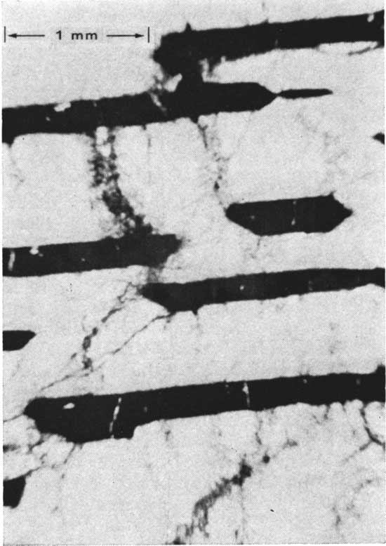
The work of Ringwood and Lovering (1970) and Dawson and Reid (1970) is mentioned here because nodules similar to their South African nodules have recently been found (although noted several years earlier) in the Stockdale kimberlite. Photomicrographs of the ilmenite-pyroxene intergrowths from both the Monastery Mine kimberlite and the Stockdale kimberlite are shown in Figures 5 and 6. It is quite obvious that there is a striking similarity. These nodules are currently being studied to determine their chemistry; their presence is offered here as further proof of crystallization of the Riley County kimberlites at depths in excess of 120 km and perhaps in excess of 300 km. The latter possibility allows a greater flexibility in both nature and amounts of upper mantle material that one may expect to find as inclusions in the kimberlites.
Figure 5--Photomicrograph of a pyroxene-ilmenite intergrowth from the Monastery, Mine kimberlite, South Africa (after Dawson and Reid, 1970).
Figure 6--Photomicrograph of a serpentinized pyroxene-ilmenite intergrowth from the Stockdale kimberlite, Riley County, Kansas.
The recent work of McGetchin (1968), Kutolin (1969), and Brookins and Woods (1970a) indicates that (1) the upper mantle may be much more heterogeneous than previously thought, and (2) even the nature of the Moho itself may be due to a combination of mineralogic, phase, and chemical changes.
Many previous workers concerned with the problems associated with kimberlitic emplacement have concentrated their efforts on thermal aspects of the history of the system, commonly on problems of heat transfer or gaseous expansion caused by pressure decrease from reservoir to final site of emplacement (Verhoogen, 1946, 1951; Boyd, 1961; Reitan, Szekely, and Foster, 1970). Only recently have workers (McGetchin, 1968; Ullrich, 1969; McGetchin and Ullrich, op. cit.) considered the problem from the viewpoint of hydrodynamics, concentrating efforts on determining fluid properties in addition to thermal properties. Much of the material which follows is modified from the work of McGetchin and Ullrich since it is applicable, albeit somewhat indirectly, to the Riley County kimberlites.
The basic equation of concern to the hydrodynamic treatment is the equation of motion, modified to include the effects of friction (McGetchin, 1968):
vdv + (dp / p) - gdx + Cf(L / D)vdv = 0 (equ. 1)
where in this and in the following equations v velocity, p = fluid pressure, ρ = fluid density, ρr = rock density, Cf = friction factor, x = position (depth), D = pipe diameter, L = pipe length, g = gravity, and T = temperature. L = dx for short segments.
Important assumptions include (a) reservoir pressure = load of overlying rock, and (b) uniform decompression of the rising fluid during eruption so that the fluid pressure exerted on the walls = local load. This is probably true and leads to defining the fluid pressure as a function of pressure by: p = ρr gx and dp = ρr gdx, which, on substitution, yields:
(1 + Cf L/D) vdv +(ρr/ρ - 1) gdx = 0 (equ. 2)
relating velocity and depth. The density relation has the form ρ = ρ[p(x),T] and must be numerically determined from the equation of state of the phases present and the equation of energy which in turn is dependent upon the equations of state of the phases present, expansion and heat transfer, kinetic considerations, and other factors. Implied changes in area and temperature are evaluated by the continuity equation: vρA = constant (A = cross-sectional area) and the energy equation:
(δS / δt) + v(δS/δz) = 0
where S = entropy, t = time, and z = vertical distance.
Desired fluid properties as a function of depth are obtained by numerical integration assuming that over short vertical increments L = dx. If the fluid phase predominant in the particulate-fluid kimberlite mixture is assumed to be water, then the data of Kennedy and Holser (1966) for water can be used to approximate the equation of state of the volatile phase. This may not be entirely true, especially for kimberlites in which carbonatitic material occurs (Brookins, 1967), but results using CO2 would be qualitatively similar (McGetchin and Ullrich, op. cit.).
McGetchin (1968) and Ullrich (1969) have used rapid computer techniques to test various models for effects of changing various parameters during fluid (kimberlitic) flow. Parameters of especial concern include gravity, volatile (water) content, and reservoir depth. This last parameter has little effect on surface flow parameters for depths greater than about 40 km because the compressibility of volatiles such as H2O or CO2 decreases sharply at pressures greater than 8 to 10 kilobars (Kennedy and Holser, 1966) and, from a hydrodynamic viewpoint, may be considered incompressible at depths exceeding 25 km. Consequently fluid flow is analogous to that of incompressible flow in a rough pipe where potential energy gain resulting from increased pipe length is dissipated by viscous drag on pipe walls and the resultant flow is similar to flow in a short pipe. Therefore, the surface conditions for all eruptions originating below about 50 km will be very similar, other properties being equal. Kushiro, et al. (1968) have further shown that the wet solidus for peridotite does not vary greatly with pressure between 10 and 50 kilobars (roughly 30 to 150 km) and a reasonable estimate of the temperature of a magma reservoir chamber is about 1000°C under most upper mantle conditions, assuming the presence of water, which cannot be disputed (see summary in Lambert and Wyllie, 1970).
McGetchin and Ullrich (op. cit.) have used the results of hydrodynamic eruption models to calculate the surface muzzle velocity of entrained solid particles as a function of their shape, size, depth of introduction, and density under hypothetical conditions. They consider the forces acting on a particle so introduced into an upward flowing fluid to include gravity, buoyancy, and fluid dynamic drag, and they demonstrate that a block will be accelerated from rest with respect to the walls (assuming lack of balance of forces) according to the expression:
m dw/dt = ρf[(vf - w)2/2] CDA - [(ρr - ρf) / ρr]mg (equ. 3)
where m = block mass, CD = drag coefficient, w = block velocity relative to the walls (the other symbols have been defined earlier). Since w = dz/dt, this expression can be numerically integrated to yield surface velocity (w at z = 0) for arbitrarily assumed block properties (m, A, ρr), depth of introduction (zinitial), and eruption parameters [vf(z) and ρf(z)]. It was found that calculated surface block velocity increases with gravity and decreases with block size, all other parameters being equal. Further, the surface velocity attained by the particles was found to be a function of the volatile content of the erupting system with an increase in velocity noted as volatile content increased.
The eruption of fluid of a maar or diatreme into the atmosphere can be viewed as interaction of high-speed let with a fluid at rest. For the Riley County kimberlites, only Winkler (and possibly Randolph No. 2) suggests that surface or near-surface final sites of emplacement were reached. Many factors affect the erupting fluid (Bliss, 1944; Sherwood, 1967; McGetchin, 1968; Rohlof, 1969), but limiting conditions on the fluid velocity may be calculated, assuming expansion of the system near the surface as a perfect gas, with the statement of the conservation of energy being:
Vs2 = V2 + [1 / (γ-1)] C2 = V2 [1 + 1 / (γ-1)M2] (equ. 4)
where Vs = surface velocity for expansion to complete vacuum, V = calculated velocity at 10 m depth, C = speed of sound at 10 m depth γ = ratio of specific heats, assumed to be 4/3, and M = Mach number (V/C). For actual eruptions, of course, the atmospheric drag will have a large effect on the trajectory of the ballistic. Further, hydrodynamic calculations including friction suggest that much potential energy is dissipated in drag.
Ullrich (1969) has commented in detail on the assumptions involved in the hydrodynamic treatment. Treatment of the fluid flow as one-dimensional is valid only for the center of the pipe and certainly not for the wall-dragged layers. More critical, however, is the assumption that fluid pressure equals the lithostatic load, as this probably requires that, at some time in the event, the entire vent was stable. To postulate this for a kimberlite which may have crystallized at some 300 km depth (Ringwood and Lovering, 1970) is extremely risky, especially in the case of Riley County kimberlites where the kink bands developed by shock in chloritized phlogopite (Brookins, 1970b) indicate periods of abrupt movement. If, however, as the author believes, much of the alteration and/or kinking occurred at depth (below the Moho) and the kimberlites were emplaced from below 40 km, then this assumption may not be unrealistic.
The assumption that the particle /volatile ratio remained constant is probably only true at depth (i.e., greater than 25 km) as there is an abundance of accidental xenoliths of limestones and shales in the Stockdale, Leonardville, and Bala kimberlites which were included late in the kimberlite histories.
The assumption of assigning water as the volatile phase is probably justified since both H2O and CO2 behave nearly identically below about 40 km and there is (at least in Riley County) isotopic evidence suggesting that much of the CO2 has been locally derived (see Brookins, 1967).
That mixtures of particles behave as perfectly mixed fluids is apparently demonstrated by the many field observations that similar modes of emplacement have occurred for very different mixtures. This may be due to the high turbulence in the erupting fluid. Assumption of a reservoir fluid temperature of 1000°C is reasonable in light of the work of Kushiro, et al. (1968) and should hold for most kimberlitic systems. To ignore heat transfer between wall rock and fluid is to assume that the walls were perfect insulators or were at the same temperature as the fluid. These adiabatic conditions, while qualitatively supported by petrographic observations (Brookins, 1970h), lack quantitative substantiation. This does not, however, introduce a large error into the resultant calculations. Using McGetchin's (1968) data, Ullrich (1969) also shows that, for kimberlite, the volatile phase expands until it is relatively cool at the surface. If a fluid velocity of only 50 m/sec is assumed, it takes three minutes for ascension from 10 km depth. Hence it is plausible that solids entrenched in the flow would be quenched, and these are the effects observed (for Riley County kimberlites as well as others). Ullrich's speculation that this quenching might explain the presence of diamonds near the surface in kimberlites in South African pipes where they are absent at depth in the same pipes may be a possible example of this type of quenching. However, some field and petrographic evidence (especially rather sluggish churning) argues against this hypothesis.
Some of Ullrich's (1969) conclusions are: (1) flow velocities below 30 km are modest and constant with mass flow rates on the order of 107 metric tons/sec; (2) above 30 km the fluid is accelerated by the expansion of the volatile phase (assumed to be the continuous phase in the case of kimberlites); (3) in the range above 700 m the Mach number surpasses unity and the dynamic pressure reaches a maximum at about 100 atmospheres; (4) at 300 m the walls flare and start the process of crater formation (which may be accompanied by gas scouring if Hansen's [1968] cratering mechanism is important); (5) at the surface, fluid velocities on the order of 400 to 600 m/sec with fluid densities of 0.02 gm/cc and volatile temperatures near 200°C are obtained; (6) the dynamic pressures of the flow models indicate that the eruptions are capable of carrying almost any material that becomes trapped in them to the surface (in the case of the Moses Rock kimberlite, this includes an approximately cubical block measuring 350 m on an edge lifted by a dynamic pressure of roughly 100 atmospheres). The dynamic pressure falls to about 30 atmospheres near the surface, and the volatile temperature decreases rapidly and becomes very cool. The fluid may well arrive in a super-cooled state depending on the kinetics of condensation. Theoretically (see Ullrich, 1969, fig. 14), a system at 960°C at 2 km depth could cool to 160°C at land surface; a system at 500°C at 2 km depth could cool to -80°C at the surface. This is particularly interesting when the Riley County and Woodson County ultrabasic rocks are compared.
The Woodson County intrusives lie at the west end of an east-west, tectonically active belt 400 miles long marked by ultramafic rock intrusions or pronounced, intrusion-induced structural effects (Snyder and Gerdemann, 1965). In the Riley County intrusives there are no pyrometamorphic contact effects and temperatures of emplacement are thought to lie in the range of 70°C (Brookins and Naeser, manuscript in preparation) to 150°C (Brookins, 1969b). In the Woodson County intrusives crystallization of high T, P minerals is accompanied by contact metamorphism (Franks, 1959; Zartman, et al., 1967). Thus it is likely that the cover in Woodson County was at least 2 km thick. In Riley County the intrusives reached, or nearly reached, land surface.
A mechanism which may facilitate crater formation during the postulated explosive events is gas scouring, first proposed by Hansen (1968) after the Palanquin nuclear blast. Typically, the crater over an underground nuclear blast is created by arching (due to the explosion) and subsequent collapse of the weakened surface material. In the Palanquin experiment, however, the grouting between the country rock and the pea-gravel-packed steel pipe over the explosive device failed, and the entire loaded pipe was explosively driven out by the blast. The sudden release of pressure caused by the grouting failure allowed entrapped gases under high pressure to be suddenly and explosively released, creating a wider and deeper crater than in the normal case with considerable gas scouring of the uppermost material with which the gas-laden mixture came into contact. This type of crater, that of a fairly wide and deep feature with a narrow vent, is common in some maar-type structures and cannot be ruled out as a complimentary factor in kimberlite emplacement, although it is doubtful that such a mechanism could be responsible for movement below about 25 km when the volatile phase of the kimberlitic fluid is incompressible.
Kimberlite and kimberlite-microbreccia are found in at least eight breccia-filled dikes in northern Arizona and southeastern Utah and have been described by Watson (1967) and McGetchin (1968). The Moses Rock dike is well exposed, approximately 8 km long, and reaches a maximum of 300 m width. It intrudes Permian sandstones and siltstones of the Cutler Formation. Contacts are sharp and deformation and contact effects minimal or missing. McGetchin (1968) has estimated that the original surface above the dike was approximately 1 mile above the present surface. The age of the dike is probably 30 m.y. (Naeser and Stuart-Alexander, 1969).
A detailed investigation by McGetchin (1968) suggests that the kimberlite minerals were derived by mechanical disaggregation of mantle rocks (spinel peridotite and garnet peridotite) in the depth range from 50 to 300 km (McGetchin and Silver, in press), and the kimberlite was emplaced as a solid-volatile fluidized system (McGetchin, 1968).
Xenoliths of the surrounding country rocks (Cutler Formation) plus other sedimentary rocks and crustally derived igneous and metamorphic rocks constitute 99 percent of the breccia, the remaining 1 percent being composed of eclogites, pyroxenites, and rare peridotites. McGetchin (1968) has proposed that the dike is part of a fissure above which several maar-type craters formed.
No diamonds have been found at Moses Rock, but the kimberlite is similar to many of the South African and Russian diamond-bearing pipes as well as to the non-diamond-bearing Riley County kimberlites.
Field exposures of the Moses Rock area are excellent, and have allowed McGetchin (1968) and Ullrich (1969) to use field and inferred theoretical data in the numerically treated hydrodynamic models. McGetchin (1968) has also included data for the Kimberley Mine, South Africa, in his treatment since the geometry of the kimberlite is well known from drilling and mining.
The Kimberley Mine has been mined to about 1 km depth and its geometry is well known (Williams, 1932). Of interest is the fact that several of the kimberlites in the Kimberley area become dikes at depth, suggesting a common fissure for their origin. The Kimberley Mine has an upward-flaring shape, very similar to the calculated dike geometries (McGetchin, 1968). Projections of wall rocks into the Kimberley pipe occupy about 20 percent of the pipe diameter, indicating that the Fanning friction factor of 0.1 used in the numerical calculations (Ullrich, 1969) is reasonable.
The comparative data for the Moses Rock, Kimberley, and Winkler kimberlites are shown in Table 3.
Table 3--Comparison of Moses Rock, Kimberley Mine, and Winkler kimberlites. Data for Moses Rock and Kimberley kimberlites from McGetchin (1968).
| Parameter | Moses Rock | Kimberley Mine | Winkler |
|---|---|---|---|
| Weight fraction H2O | 0.10 | 0.25 | 0.09 (1) |
| Width (2-km depth) | 174 m | 53 m | |
| Width (surface) | 432 m | 250 m | 300 m |
| Surface velocity | 430 m/sec | 750 m/sec | 400 m/sec (2) |
| Surface temperature during final emplacement | 98.9°C | 100°C (max.) | 100 ± 50°C (3) |
| Dynamic pressure (surface) | 51.7 atm | 50 atm (2) | |
|
(1) Average of four analyses for Riley County kimberlites (Brookins, 1970b). (2) Obtained from data given in Ullrich (1969) using known parameters (T, XH2O, width). (3)From Brookins and Naeser (manuscript in preparation); based on fission track and K-Ar data. |
|||
Kink bands are noted in the chloritized phlogopites from the Stockdale, Leonardville, and Winkler kimberlites and have been previously discussed by Brookins (1970b) and Dyer (1970). Their significance is not fully understood, although Short (1966) attributes such features to shock induced (presumably) by abrupt movement at some time in the rocks' history. Horz and Ahrens (1969) and Horz (1970) have made a much more comprehensive study of dynamic and static shock features and have attempted to quantitatively relate the kinking observed in micas to T, P conditions during both possible types of origin. Unfortunately, their data are somewhat inconclusive in placing T, P limits on conditions for dynamic as opposed to static deformation; but useful criteria for distinguishing between the two types are noted. Dynamic deformation involving rapid tectonic or explosive conditions usually results in a set of narrow kink bands, whereas static deformation over a longer time interval results in wider, sometimes bent, sets of kinks.
The Riley County kimberlites possess kink bands which appear to be the result of dynamic conditions and which have been interpreted by Brookins (1970b) and Dyer (1970) to be due to periods of abrupt tectonic movement. Several sets of kink bands are noted in some chlorites (four recorded in one Leonardville sample), and these evidently indicate different events, as alteration products developed along the weakened kink zone representing an early event are offset by later kinking. This evidence places some limits on the emplacement history of the kimberlites. It is unlikely that the kimberlites could have been emplaced from their reservoir to their final emplacement site in one continuous event. Petrographic evidence for several periods of alteration (Brookins, 1970b) plus the evidence from kink bands in chloritized phlogopites argues for a series of violent movements, most of which probably occurred at depth. Using data from Horz (1970) as a guide, the pressures were probably greater than 7 to 10 kilobars. These movements occurred prior to a final event which may have originated in the upper mantle and which resulted in the kimberlite emplacement. Until more quantitative experimental data for minerals such as chlorite are obtained these remarks are necessarily speculative; however, more than one period of tectonic activity affecting the kimberlites (at depth) is indicated.
The conclusions reached from this study are relatively few but are significant. Any quantitative results obtained from the kimberlite "moholes" theoretically hold the answers to many problems of upper mantle petrology, tectonism, and modes of emplacement. The conclusions are:
Bailey, D. K., 1964, Temperature and vapor composition in carbonatite and kimberlite: Carnegie Inst. Wash., D.C., Yrbk. 63, p. 79-81.
Bliss, G. A., 1944, Mathematics for Exterior Ballistics: John Wiley and Sons, Inc., New York, 404 p.
Boyd, F. R., 1961, Welded tuffs and flows in the Rhyolite Plateau of Yellowstone Park, Wyoming: Geol. Soc. America, Bull., v. 72, p. 387-426.
Boyd, F. R., and MacGregor, I. D., 1964, Ultramafic rocks: Carnegie Inst. Wash., D.C., Yrbk. 63, p. 152-156.
Bridge, T. E., 1953, The petrology and petrography of the igneous rocks of Riley County, Kansas: Unpub. M.S. thesis, Dept. Geol., Kansas State University, 57 p.
Brookins, D. G., 1967, The strontium geochemistry of carbonates in kimberlites and limestones from Riley County, Kansas: Earth Plan. Sci. Letters, v. 2, p. 235-240.
Brookins, D. G., 1969a, Riley County, Kansas, kimberlites and their inclusions (abs.): Geol. Soc. America, Abstracts for 1969, Pt. 2, South-Central Section, p. 4.
Brookins, D. G., 1969b, The significance of K-Ar dates on altered kimberlitic phlogopite from Riley County, Kansas: Jour. Geol., v. 77, p. 102-107.
Brookins, D. G., 1969c, Possible age of crystallization of pyrope from the Stockdale kimberlite, Kansas: Geochem. Jour., v. 3, p. 135-140.
Brookins, D. G., 1970a, Kimberlite at Winkler Crater, Kansas: Geol. Soc. America Bull., v. 81, p. 541-546.
Brookins, D. G., 1970b, The kimberlites of Riley County, Kansas: Kansas Geol. Survey, Bull. 200, 32 p. [available online]
Brookins, D. G., and Woods, M. J., 1970, Rb-Sr geochronologic investigation of basic and ultrabasic xenoliths from the Stockdale kimberlite, Riley County, Kansas: Kansas Geol. Survey, Bull. 199, pt. 2, 12 p. [available online]
Brookins, D. G., and Woods, M. J., 1970a, High pressure mineral reactions in a pyroxenite granulite nodule from the Stockdale kimberlite, Riley County, Kansas: Kansas Geol. Survey Bull. 199, pt. 3, 6 p. [available online]
Byrne, F. E., Parish, K. L., and Crumpton, C. F., 1956, Igneous intrusions in Riley County, Kansas: Am. Assoc. Petroleum Geologists Bull., v. 40, p. 377-387.
Cook, K. L., 1955, Magnetic surveys over serpentine masses, Riley County, Kansas: Mining Eng., v. 7, p. 481-488.
Dawson, J. B., 1962, Basutoland kimberlites: Geol. Soc. America Bull., v. 73, p. 545-560.
Dawson, J. B., 1967, 8, II. A Review of the Geology of Kimberlite; in Ultramafic and Related Rocks, Wyllie, P. J., Ed.: John Wiley and Sons, Inc., New York, p. 241-251.
Dawson, J. B., 1968, Recent researches on kimberlite and diamond geology: Econ. Geol., v. 63, p. 504-511.
Dawson, J. B., and Reid, A. M., 1970, A pyroxene-ilmenite intergrowth from the Monastery Mine, South Africa: Contrib. Mineral. Petrol., v. 26, p. 296-301.
Dowell, A. R., 1964, A magnetic investigation of northern Riley County, Kansas: Unpub. M.S. thesis, Dept. Geol., Kansas State University, 84 p.
Dreyer, R. M., 1947, Magnetic survey of the Bala intrusive, Riley County, Kansas: Kansas Geol. Survey, Bull. 70, pt. 2, p. 21-28. [available online]
Dyer, R. G., 1970, Petrology of the Leonardville kimberlite: Unpub. M.S. thesis, Dept. Geol., Kansas State University, 78 P.
Franks, P. C., 1959, Pectolite in mica peridotite, Woodson County, Kansas: Amer. Mineral., v. 44, p. 1082-1086.
Hansen, S. M., 1968, A crater formed by gas erosion of a nuclear explosion vent: Meteoritics, V. 4, p. 61-88.
Horz, F., 1970, Static and dynamic origin of kink bands in micas: Jour. Geophys. Res., v. 75, p. 965-977.
Horz, F., and Ahrens, T. J., 1969, Deformation of experimentally shocked biotite: Am. Jour. Sci., v. 267, p. 1213-1229.
Kennedy, G. C., and Holser, W. T., 1966, Pressure-volume-temperature and phase relations of water and carbon dioxide: Sec. 16, Handbook of Physical Constants: Geol. Soc. America, Mem. 97, p. 371-384.
Kennedy, G. C., and Nordlie, B. E., 1968, The genesis of diamond deposits: Econ. Geol., v. 63, p. 495-503.
Kitahara, S., Takenouchi, S., and Kennedy, G. C., 1966, Phase relations in the system MgO-SiO2-H2O at high temperatures and pressures: Am. Jour. Sci., v. 264, p. 223-233.
Kushiro, I., Syono, Y., and Akimoto, S., 1967, Stability of phlogopite at high pressures and possible presence of phlogopite in the earth's upper mantle: Earth Plan. Sci. Letters, v. 3, p. 197-203.
Kushiro, I., Syono, Y., and Akimoto, S., 1968, Melting of a peridotite nodule at high pressures and high water pressures: Jour. Geophys. Res., v. 73, p. 6023-6030.
Kutolin, V. A., 1969, Ultrabasic nodules in basalts and the upper mantle composition: Earth Plan. Sci. Letters, v. 7, p. 330-332.
Lambert, I. B., and Wyllie, P. J., 1970, Low-velocity zone of the earth's mantle: Incipient melting caused by water: Science, v. 169, p. 764-766.
Lidiak, E. G., 1969, Buried Precambrian rocks of eastern Kansas (abs.): Geol. Soc. America, Abstracts for 1969, Pt. 2, South-Central Section, p. 17-18.
McGetchin, T. R., 1968, The Moses Rock dike: Geology, petrology, and mode of emplacement of a kimberlite bearing breccia dike, San Juan County, Utah: Unpub. Ph.D. thesis, California Inst. Tech., 405 P.
McGetchin, T. R., and Silver, L. T., (in press), Compositional relations in minerals from kimberlite and related rocks from Moses Rock dike, San Juan County, Utah: Am. Mineralogist.
Merriam, D. F., 1963, The geologic history of Kansas: Kansas Geol. Survey, Bull. 162, 317 p. [available online]
Merryman, R. J., 1957, Geology of the Winkler area, Riley County, Kansas: Unpub. M.S. thesis, Dept. Geol., Kansas State University, 34 p.
Meyer, H. O. A., 1967, Mineral inclusions in diamonds: Carnegie Inst. Wash., D.C., Yrbk. 66, p. 446-450.
Meyer, H. O. A., and Boyd, F. R., 1969, Inclusions in diamonds: Carnegie Inst. Wash., D.C., Yrbk. 68, p. 315-320.
Muehlberger, W. R., Hedge, C. E., Denison, R. E., and Marvin, R. F., 1966, Geochronology of the Midcontinent Region, United States, 3. Southern area: Jour. Geophys. Res., v. 71, p. 5409-5426.
Naeser, C. W., and Stuart-Alexander, D., 1969, The age and temperature of the Mule Ear diatreme, south-eastern Utah (abs.): Geol. Soc. America, Abstracts for 1969, Pt. 7, p. 155-156.
Reitan, P. H., Szekely, J., and Foster, B. P., 1970, Material emplacement models for dikes extending to the mantle (abs.): Trans. Am. Geophys. Union, v. 51, p. 447.
Ringwood, A. E., and Lovering, J. F., 1970, Significance of pyroxene-ilmenite intergrowths among kimberlite xenoliths: Earth Plan. Sci. Letters, v. 7, p. 371-375.
Rohlof, K. J., 1969, Analysis of the exterior ballistics of block ejecta at Nanwaksjiak Crater, Nunivak Island, Alaska: Unpub. M.S. thesis, Air Force Inst. Tech., 213 p.
Rosa, F., and Brookins, D. G., 1966, The mineralogy of the Stockdale kimberlite pipe, Riley County, Kansas: Kansas Acad. Sci., Trans, v. 69, p. 335-344.
Sherwood, A. E., 1967, Effect of air drag on particles ejected during explosive cratering: Jour. Geophys. Res., v. 72, p. 1783-1792.
Short, N. M., 1966, Shock processes in geology: Jour. Geol. Ed., v. 14, p. 149-166.
Snyder, F. G., and Gerdemann, P. E., 1965, Explosive igneous activity along an Illinois-Missouri-Kansas axis: Am. Jour. Sci., v. 263, p. 465-493.
Ullrich, G. W., 1969, Numerical hydrodynamic models for steady flow in erupting maar-type volcanoes: Unpub. M.S. thesis, Air Force Inst. Tech., 203 p.
Verhoogen, J., 1946, Volcanic heat: Am. Jour. Sci., v. 244, p. 745-771.
Verhoogen, J., 1951, Mechanics of ash formation: Am. Jour. Sci., v. 249, p. 729-736.
Watson, K. D., 1967, 8, IV. Kimberlite Pipes of Northeastern Arizona; in Ultramafic and Related Rocks, P. J. Wyllie, ed.: John Wiley and Sons, Inc., New York, p. 261-269.
Williams, A. F., 1932, The Genesis of the Diamond: E. Benn, London, 636 p.
Woods, M. J., 1970, Petrography and geochronology of basic and ultrabasic inclusions from kimberlites of Riley County, Kansas: Unpub. M.S. thesis, Dept. Geol., Kansas State University, 95 p.
Yoder, H. S., and Kushiro, I., 1969, Melting of a hydrous phase phlogopite: Am. Jour. Sci., v. 267-A, p. 558-582.
Zartman, R. E., Brock, M. R., Heyl, A. V., and Thomas, H. H., 1967, K-Ar and Rb-Sr ages of some alkalic intrusive rocks from Central and Eastern United States: Am. Jour. Sci., v. 265, p. 848-870.
Zeller, D. E., (ed.), 1968, The stratigraphic succession in Kansas: Kansas Geol. Survey Bull. 189, 81 p. [available online]
Kansas Geological Survey, Geology
Placed on web Sept. 25, 2008; originally published in Dec. 1970.
Comments to webadmin@kgs.ku.edu
The URL for this page is http://www.kgs.ku.edu/Publications/Bulletins/199_4/index.html