![]()
Prev Page--Systematic Descriptions || Next Page--Plates
Appendix
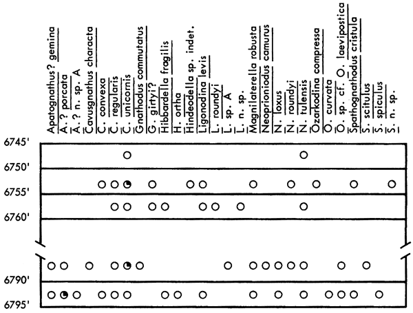
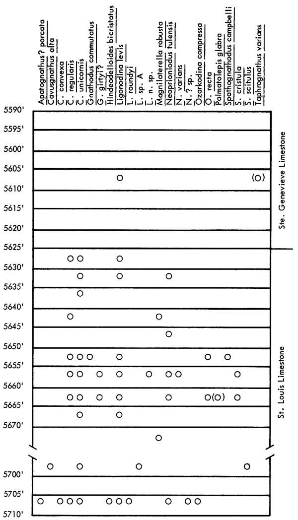
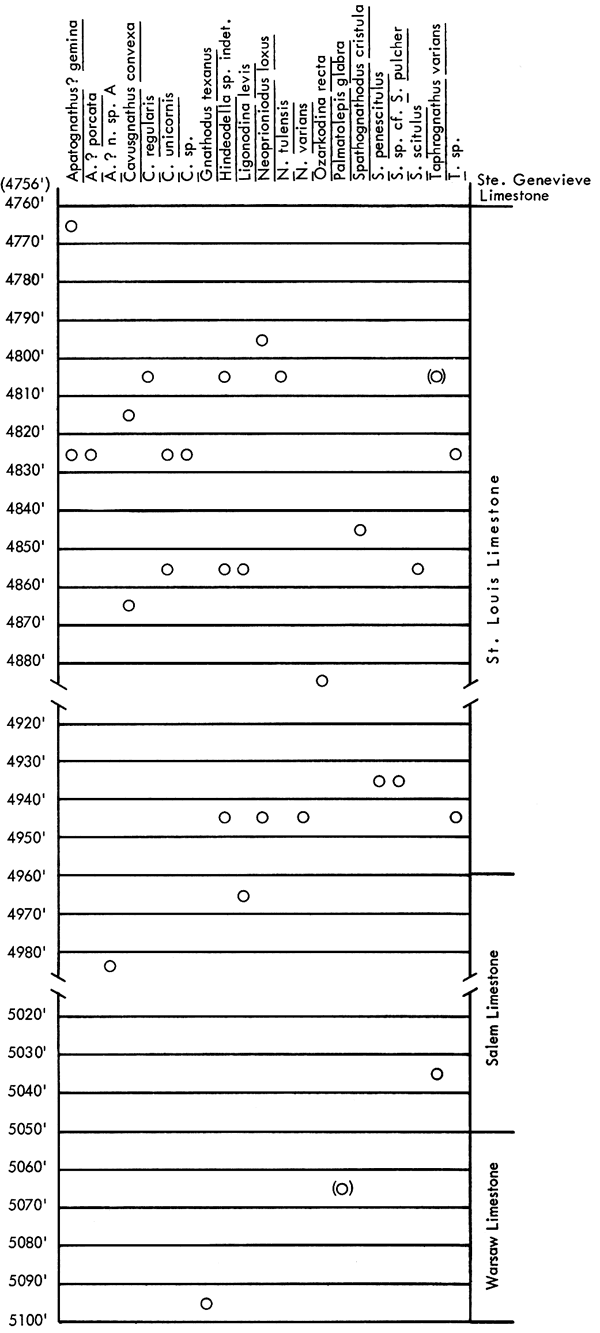
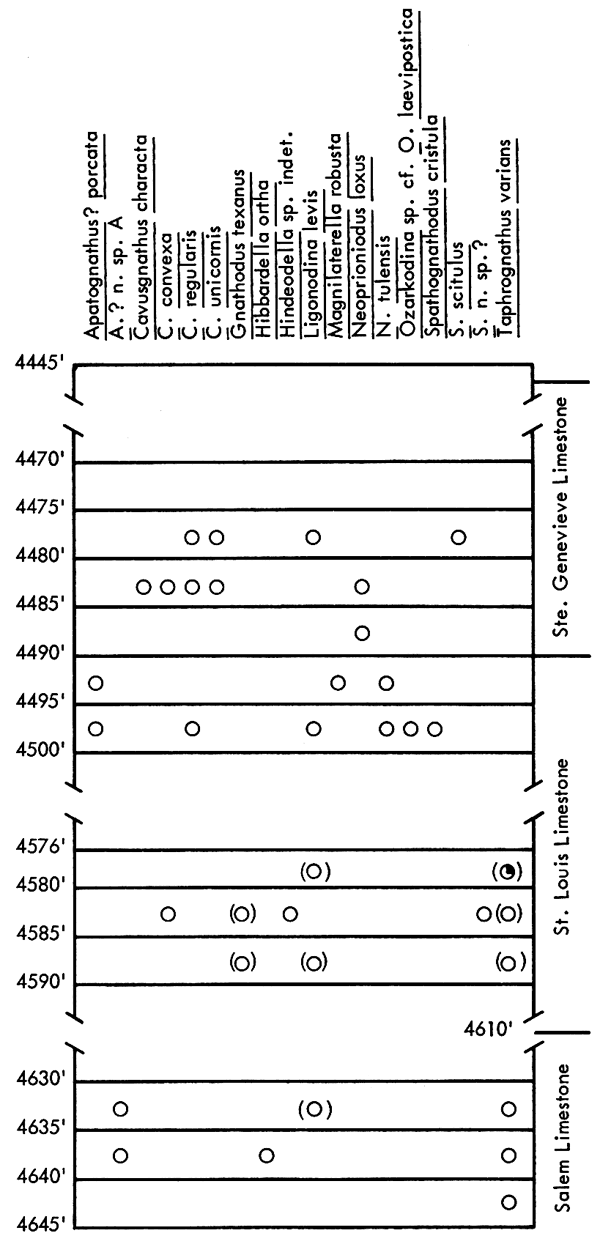
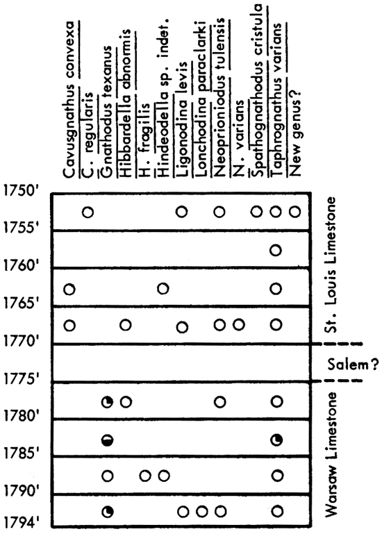
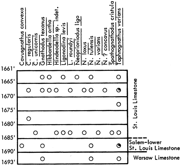
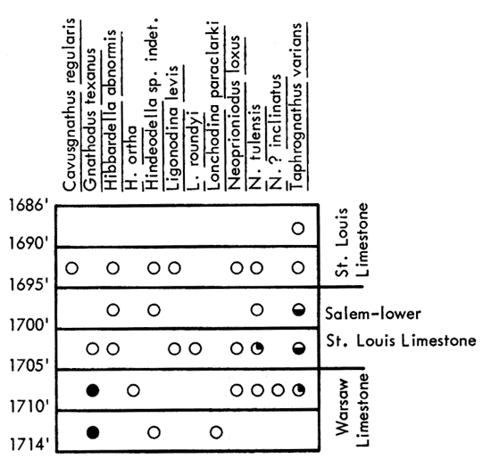
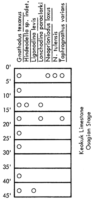
In the following illustrations, both figured and unfigured specimens are included in the compound footage increments and are plotted arbitrarily between footage lines. For example, specimens referred to in the text as from 4971 feet have been lumped together with those from 4970 to 4975, for convenience in reporting.
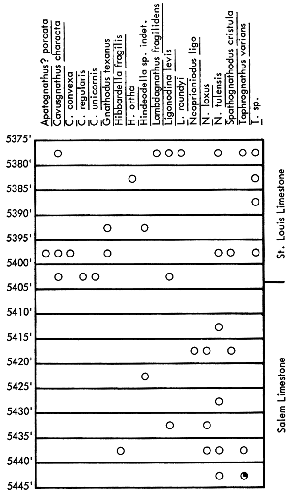
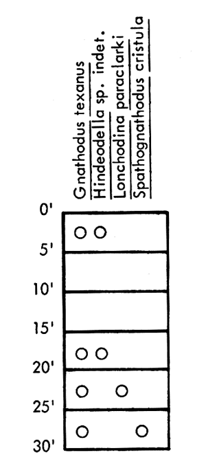
Core A--Distribution and abundance of conodonts from the St. Louis Limestone recovered from the Mobil Oil Co. No. Cunningham Est., C SW SE sec. 13, T. 34 S., R. 37 W., Stevens County, Kansas.
Core B--Distribution and abundance of conodonts recovered from the Cities Service No. 1 Kells "B,", C NW NW sec. 5, T. 28 S., R. 34 W., Haskell County, Kansas.
Core C--Distribution and abundance of conodonts recovered from the Atlantic Oil Co. No. 1-A Mark, SE SE SE sec. 28, T. 20 S., R. 33 W., Scott County, Kansas.
Core D--Distribution and abundance of conodonts recovered from the Alma and McNeeley No. 1 Watchorn, C SW NE sec. 13, T. 15 S., R. 33 W., Logan County, Kansas.
Core E--Distribution and abundance of conodonts recovered from the Mobil Oil Co. No. 1 Winans, C SE NW sec. 32, T. 20 S., R. 27 W., Lane County, Kansas.
Core F--Distribution and abundance of conodonts recovered from the Mid-Continent No. 1 Collins, C NW NW sec. 24, T. 20 S., R. 26 W., Ness County, Kansas.
Core G--Distribution and abundance of conodonts recovered from the Mobil Oil Co. No. 1 Elsasser Heirs, C SE SW sec. 29, T. 18 S., R. 22 W., Ness County, Kansas.
Core H--Distribution and abundance of conodonts recovered from the Mull-Mobil Oil Co. No. 1 Matkin, C NE NW sec. 16, T. 27 S., R. 21 W., Ford County, Kansas.
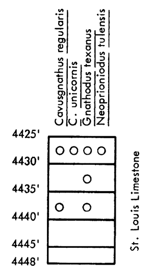
Core I--Distribution and abundance of conodonts recovered from the Sinclair-Prairie No. 1 Exchange Bank, C SE SW sec. 27, T. 33 S., R. 19 W., Comanche County, Kansas.
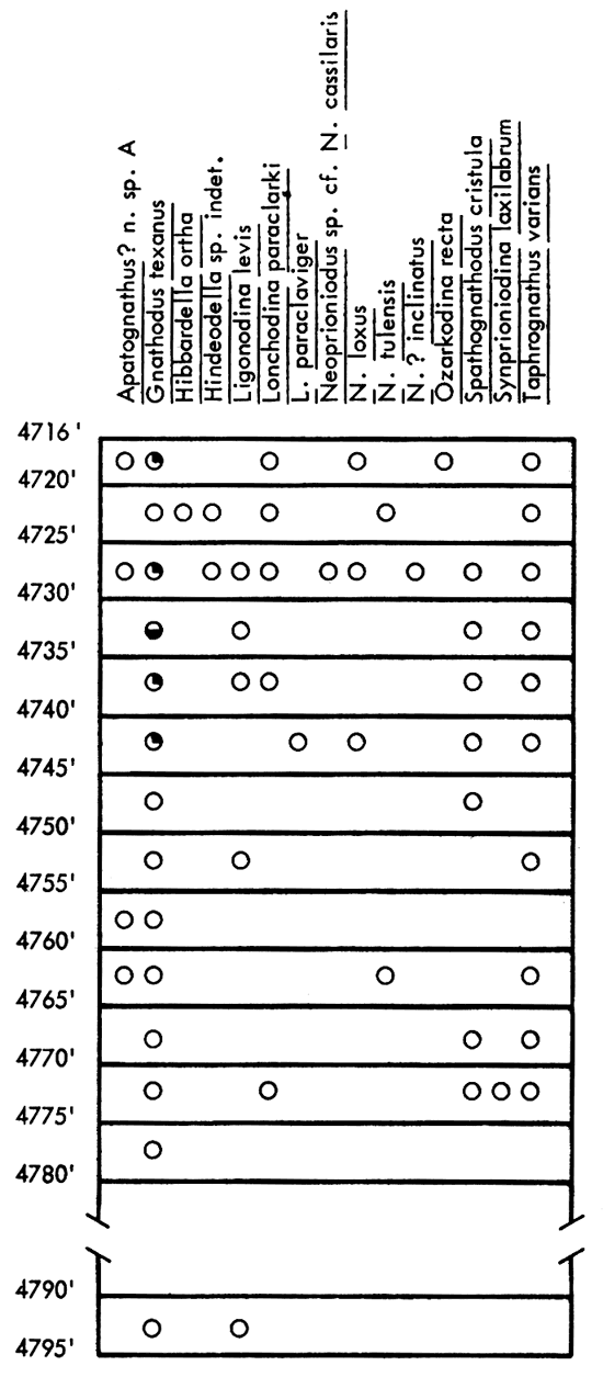
Core J--Distribution and abundance of conodonts recovered from the Sinclair Oil and Gas No. 1 Colburn "A,", NE SW NE sec. 9, T. 33 S., R. 11 W., Barber County, Kansas.
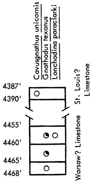
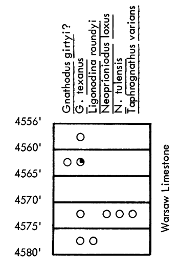
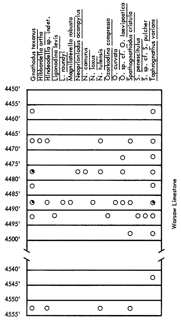
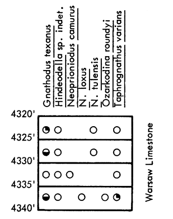
Core K--Distribution and abundance of conodonts recovered from the Warsaw Limestone from the Sinclair Oil and Gas No. 1 Helmley, SW SW SE sec. 3, T. 35 S., R. 10 W., Barber County, Kansas.
Core L--Distribution and abundance of conodonts recovered from the Kessler and Thier No. 1 Wolfje, C SW SW NE sec. 17, T. 35 S., R. 6 W., Harper County, Kansas.
Core M--Distribution and abundance of conodonts recovered from the Western Petroleum Co. No. 1 Dalton "B,", SW NE SE sec. 11, T. 24 S., R. 12 E., Greenwood County, Kansas.
Core N--Distribution and abundance of conodonts recovered from the Sinclair Oil and Gas Co. No. 6 H.G. Collins, C SE NE sec. 30, T. 23 S., R. 14 E., Woodson County, Kansas.
Core O--Distribution and abundance of conodonts recovered from the Sinclair Oil and Gas Co. No. 12 W.P. Headley "A,", SE NW NW sec. 32, T. 23 S., R. 14 E., Woodson County, Kansas.
Core P--Distribution and abundance of conodonts recovered from Mississippian outcrop of the Keokuk Limestone (Osagian), SE NW sec. 1, T. 35 S., R. 25 E., Cherokee County, Kansas.
Core Q--Distribution and abundance of conodonts recovered from Mississippian outcrop of the Keokuk Limestone (Osagian), NE NE SW sec. 33, T. 34 S., R. 25 E., Cherokee County, Kansas.
Prev Page--Systematic Descriptions || Next Page--Plates
Kansas Geological Survey, Geology
Placed on web June 24, 2010; originally published Dec. 1968.
Comments to webadmin@kgs.ku.edu
The URL for this page is http://www.kgs.ku.edu/Publications/Bulletins/192/07_app.html