![]()
Prev Page--Introduction || Next Page--Conodont fauna
Meramecian Rocks
The Meramecian lithostratigraphic units recognized in Kansas (Fig. 2) are, in ascending order, the Warsaw, Salem, St. Louis, and Ste. Genevieve limestones (equivalent to the Warsaw, Salem, St. Louis, and Ste. Genevieve formations of the Mississippi River Valley). Meramecian stage and formation names were extended into the subsurface of Kansas from outcropping areas in Missouri and the upper Mississippi River Valley by Lee (1940). Carbonate rocks are dominant in these strata. In western Kansas, the Salem, St. Louis, and Ste. Genevieve limestones were collectively termed the "Watchorn Formation" (Lee, 1940) before it was possible to differentiate the subdivisions.
Figure 2--Lithostratigraphic units of the Meramecian Stage recognized in the subsurface in Kansas.
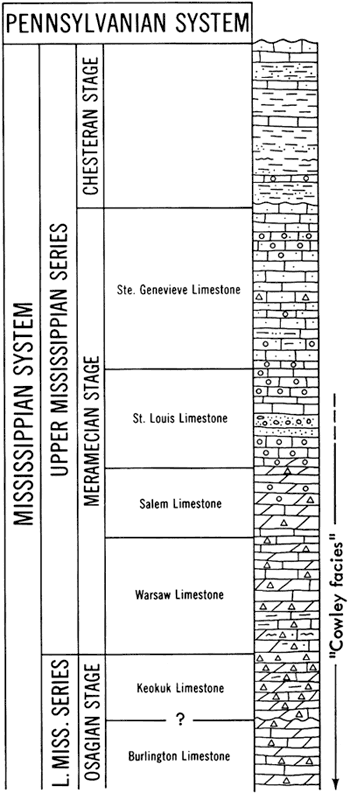
Lee did not identify the Watchorn in south-central Kansas, where he mapped the Cowley Formation. Later, Lee (1949, 1953) recognized subdivisions of the Watchorn in a limited area of south-central and southwestern Kansas. Data from many more wells than were available to Lee makes possible the subdivisions used in this report.
The thickness of Meramecian rocks ranges from zero in certain places along the trend of the Central Kansas uplift to a known thickness of more than 850 feet in the Hugoton embayment. Meramecian rocks, except for the Ste. Genevieve Limestone, probably originally extended throughout Kansas but were eroded from post-Mississippian highs in early Pennsylvanian time. The distribution pattern of Meramecian formations roughly outlines early Pennsylvanian structural features (Fig. 3). Possible regression of the Meramecian sea in late Meramecian time provided an environment in which some upper Meramecian rocks were eroded before the deposition of Chesteran rocks.
Figure 3--Areal geologic map of Mississippian rocks in Kansas.
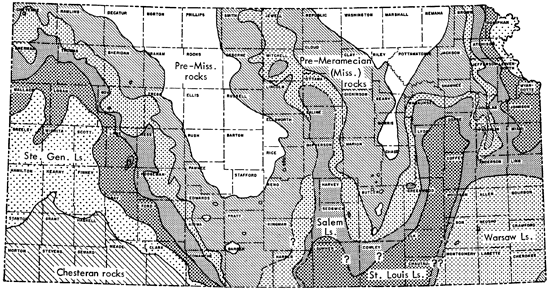
In extreme southwestern Kansas, Meramecian rocks unconformably underlie Chesteran rocks. Elsewhere in Kansas, Meramecian rocks unconformably underlie Pennsylvanian rocks. The unconformity between Meramecian rocks and Osagian rocks is obscure in northeastern and southwestern Kansas.
Maher and Collins (1949) reporting on the Hugoton embayment of southwestern Kansas, southeastern Colorado, and the Oklahoma Panhandle observed:
The group [Meramecian rocks] thins at both the top and bottom--the thinning at the top is due to the removal by erosion of the Ste. Genevieve, St. Louis, and part of the Spergen [Salem] limestone to the north and east--the thinning at the bottom is due to onlap of the group to the west, north and east, probably resulting in the loss of the Warsaw limestone in the northern part of the embayment and the loss of the Warsaw, Spergen, and most of the St. Louis strata in the southwestern part.
Thinning of formations toward the north and east due to late Mississippian and early Pennsylvanian erosion was observed in western Kansas. No thinning at the bottom was mapped.
Removal by late- and post-Mississippian erosion of rocks from structural highs in Kansas and the widespread development of a residual cherty surface where Mississippian rocks were preserved inhibits lithologic comparisons of formations in distantly separated areas. This erosion reduced the Mississippian surface, preserving greater thickness of Mississippian deposits in synclines (Lee, 1940), or in topographic lows. Reworked chert deposited on the eroded surface of Mississippian limestones is difficult to differentiate from chert weathered in place (residual chert). Locally the residual chert at the top of the Mississippian sequence is as much as 50 feet thick. Osagian rocks are dominantly chert. Difficulty in discerning Mississippian formations has led to widespread use by geologists concerned with oil and gas exploratory drilling of the term "Mississippi lime" for cherty Mississippian rocks.
Warsaw Limestone
Outcrops
The Warsaw Limestone was named by Hall (1857) from outcrops near Warsaw, Illinois. Scattered exposures of the Warsaw occur throughout Missouri. In southwestern Missouri, it has been subdivided into numerous units designated by letters (Fowler, Lyden, Gregory, and Agar, 1935).
The position of the boundary between the Osagian Stage and the Meramecian Stage has long been a point of dispute. Spreng (1961, p. 66) reported that some workers regarded the Warsaw in the outcrop areas as the lowest formation in the Meramecian Stage because its clastic (quartz sand and silt) character differed from the calcareous composition of the Keokuk (Osagian) and also because its fauna contained many new species not present in the Keokuk. The Warsaw has been placed in the uppermost Osagian by other geologists because its fauna resembles the Keokuk fauna in many respects, and the boundary between the two formations is obscure in many places. Spreng, however, regarded the Warsaw as the basal formation in the Meramecian and considered it to be in conformable relationship with underlying Osagian rocks. In eastern Missouri, the Warsaw Formation is separated from the overlying Salem (Spergen) Formation by an unconformity and is considered as late Osagian in age, according to Harris and Parker (1964). Hayes (1961) reported a conformable relationship between the Warsaw and Keokuk and a local unconformity between lower and upper Warsaw strata in the Keokuk, Iowa, region. An unconformity above the "Warsaw-like material" in southwestern Missouri has been reported by Fowler and Lyden (1935).
In the type area in the upper Mississippi River Valley, the Osagian and Meramecian are not recognized and the rocks between the Kinderhookian and Chesteran are designated the Valmeyeran Series, which includes the Warsaw. There is general similarity of conodont faunas from late Osagian rocks (Keokuk) and early Meramecian rocks (Warsaw-Salem) in Kansas and in the type area, but the proportion of species in the two is quite different.
Moore, Frye, Jewett, Lee, and O'Connor (1951) placed the Warsaw in the Meramecian in Kansas. The pre-Pennsylvanian section of that report was prepared by Lee and follows earlier work by Lee (1940, 1949). Lee (1956) placed the Warsaw in the Meramecian on the grounds of an identified unconformity at the base of the Warsaw in the subsurface, and because there was no evidence for an unconformity with overlying rocks.
Correlation of the little-known Mississippian outcrops in the extreme southeastern corner of Kansas has been in dispute. Some workers in Missouri and Oklahoma have mapped these strata as Keokuk (Lee, 1940, p. 55). The basal 20 feet of outcrop (Loc. P) in sec. 1, T 35 S, R 25 E (Cherokee County) consists of thick beds of white, fossiliferous chert, containing thin gray limestone beds capped by 30 to 35 feet of gray, dense limestone, partly crinoidal and coarsely crystalline to very finely crystalline. In this outcrop the basal chert and limestone beds previously have been assigned to the Keokuk and the overlying limestone to the Warsaw. This Mississippian outcrop was identified by Fowler and Lyden (1932) as a portion of the "M bed," lying beneath the Short Creek Oolite Member of the Keokuk Limestone.
The abundant occurrence of Gnathodus texanus Roundy in about a 50:2 ratio with Taphrognathus recovered from residue studies of outcrop samples, indicates a late Osagian age (G. texanus-Taphrognathus Zone). The Warsaw Limestone in Kansas is considered to be entirely Meramecian (Goebel, 1968).
"Cowley facies"
In the southern tier of Kansas counties, from Cherokee on the east to Barber on the west, Lee (1940, p. 66) reported that a concentration of glauconite occurs progressively lower stratigraphically westward in pre-Meramecian rocks. He stated that the glauconite is overlain by thick deposits of gray and dark-colored silty and cherty dolomitic limestone beds that are stratigraphically below the base of the Warsaw. These rocks, together with a glauconitic zone at the base, Lee designated as the "Cowley Formation." Lee mapped the Cowley Formation as cutting out in different areas the Keokuk, Burlington, Reeds Spring, and St. Joe limestones (see Lee, 1940, cross-section F-F', pt. 7). Lee mapped the Cowley as resting in places on the Northview Shale, Compton Limestone, Chattanooga Shale, and even on pre-Chattanooga beds. The Cowley is not present in Missouri (Lee, 1940, p. 68) but the "J-bed" of the Warsaw in the Tri-state Mining District is an eastward continuation of the transgressive basal portion of the Cowley. Lee (1953, p. 14) traced the "Cowley Formation" as far west as Meade County where no glauconite is present at the base.
Lee (1940) recognized no break between the Cowley and the Warsaw in western Kansas. In a cross-section from Meade County to Smith County, Kansas, Lee (1953) showed the Warsaw as conformable upon the Cowley Formation. The Cowley Formation as reported by Lee (1940, 1949, 1953, 1956) is characterized by "discontinuity of sedimentation," and its most distinctive rocks are silty and siliceous dolomite, limestone, and dolomitic siltstone. In some areas large quantities of gray and dark-colored opaque fossiliferous chert are present (Lee, 1940, p. 15).
These variations in sedimentary sequence have led some geologists to conclude that the Cowley is a facies of the Keokuk-Burlington-Fern Glen limestones and the Chattanooga Shale. A possible explanation of the discontinuity of sedimentation typical of the Cowley, suggested from sample and core examinations, is that selective and partial chertification locally of rocks from this interval has occurred.
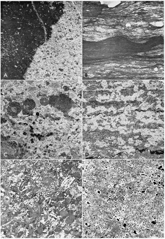
In a footnote, Lee (1940, p. 109) described cores from the Kessler and Thier, Inc. No. 1 Wolfje in Harper County (Core L) as "lithologically and stratigraphically from the Cowley Formation" (Fig. 4, A, B, C). [Note: well name is actually Woltje.] Residues from the Wolfje core included specimens of Cavusgnathus, indicative of late Meramecian age, mixed with Gnathodus texanus. These conodonts and others from cores I and K in the area of the "Cowley" are listed in Table 1 and the distribution given in the Appendix. Cavusgnathus first appears in the Apatognathus? gemina-Cavusgnathus Zone of the type area. Collinson, et al. (1962) referred this zone to the upper part of the St. Louis Limestone. Gnathodus texanus seemingly does not range above the Taphrognathus varians-Apatognathus? Zone of the type area. The biostratigraphic zone represented by the mixed fauna from the Wolfje core is correlated with the A.? gemina-Cavusgnathus Zone. The rocks of the Wolfje core are no older than late Meramecian.
Obviously, assignment of this rock interval in the Wolfje core to the St. Louis Limestone implies its former continuity with the St. Louis Limestone elsewhere in southwestern Kansas and demands relegation of the "Cowley Formation" to "Cowley facies" in the immediate area. The term "Cowley Formation" has been abandoned (Goebel, 1968b). The "Cowley facies" "masks" the Warsaw Limestone (Fig. 4, D) in the Sinclair Oil and Gas No. 1 Helmley core (Core K). Locally within the area of the "Cowley facies" the Mississippian rocks are unaltered. Goebel (1966) reported such local areas of Osagian rocks in Barber County. Similarity of the "kicks" (a converging pattern downhole) occurs in the interval of the "Cowley facies" on the electric logs and other mechanical logs.
Figure 4--Polished core slabs from St. Louis Limestone from Harper County (A-C), and Warsaw Limestone from Barber County (D), Ness County (E), and Greenwood County (F). A-C, Kessler and Thier No. 1 Wolfje, Harper County, Kansas (Core L, Table 1). Lee (1940, p. 109) described the core interval from 4,425-4,439 feet in this borehole as "lithologically and stratigraphically from the Cowley Formation." A mixed conodont fauna from residues indicates late Meramecian age. A, "Cowley facies" of the St. Louis Limestone (4,430 feet); peel-print of calcarenite with pieces of bluish-white microfossiliferous chert, X3. B, "Cowley facies" of the St. Louis Limestone (4,436 feet); photograph of wavy-bedded, calcareous, silty shale with random pieces of chalky and chalcedonic chert, X1. C, "Cowley facies" of the St. Louis Limestone (4,440 feet); peel-print of semicrinoidal limestone with pieces of bluish-white microfossiliferous chert, X3. Groundmass is crystalline calcite. D, "Cowley facies" of the Warsaw Limestone (4,790 feet); peel-print of chalky, calcareous, shaly, stylolitic chert, X3. Residues nearly 85 percent by weight. From Sinclair Oil and Gas No. 1 Helmley (Core K), Barber County. E, Warsaw Limestone (4,492 feet); peel-print of "mixed fossil" fragmental limestone containing little chert, X3. From Mid-Continent No. 1 Collins (Core F), Ness County. F, Warsaw Limestone (1,782 feet); peel-print of "fossil-casts" In siliceous dolomite, X3. From Western Petroleum Co. No. 1 Dalton "B" (Core M), Greenwood County.
Subsurface character
The Warsaw Limestone is described from drill cuttings in Kansas outside the area of the "Cowley facies" as semigranular to coarsely crystalline limestone interlaminated with saccharoidal dolomite. It contains varying amounts of gray, mottled, opaque, micro fossiliferous chert. Geodic and drusy quartz are local constituents. The residues from the dolomite beds are spongy masses of spicules in some cases. Molds of fossils are present. Pyrite and glauconite are disseminated throughout the formation, and glauconite is locally concentrated near the base.
Core and residue data
The "Cowley facies" of the Warsaw Limestone in Barber County in Core K (Fig. 4, D) is laminated, cherty limestone and chalky calcareous chert that is stylolitic. In cores from Kiowa and Hodgeman counties (Goebel, 1966), the Warsaw Limestone lies directly below Pennsylvanian rocks and is made up of conglomeratic, sandy, dolomitic shale, containing chert. Post-depositional and post-chert fracturing and faulting is exhibited in the Warsaw Limestone in Hodgeman County. In Ness County, in addition to "mixed-fossil" fragmental limestone (Fig. 4, E), the Warsaw Limestone is breccia with large fragments of finely crystalline limestone interspersed with green, silty, clayey shale. Fowler and Robbie (1961) defined this lithology as "quasi-breccia." Thompson and Goebel (1963) applied the term to the Warsaw Limestone in Core F. The Warsaw Limestone of Scott County consists of calcarenite as well as cherty limestone. Residues contain typical Warsaw glauconite. In Greenwood County, the Warsaw (Core M) contains beds of "fossil-casts" in siliceous dolomite (Fig. 4, F).
Thickness, distribution, and stratigraphic relationships
The Warsaw thins toward structural highs such as the Central Kansas uplift and the Nemaha anticline and thickens southward toward the Oklahoma Panhandle. It is more than 250 feet thick in its maximum development in Meade County, Kansas. It is 30-40 feet thick in the Forest City and Salina basins.
Overlap of Warsaw Limestone by Salem Limestone and St. Louis Limestone from northeastern Kansas Into Iowa was illustrated by Lee (1956). The Warsaw and upper Osagian rocks once probably extended over the Central Kansas uplift but were removed by pre-Chesteran or early Pennsylvanian erosion (Fig. 3).
Local concentrations of glauconite in the lower part of the Warsaw in western Kansas mark a disconformity above the Keokuk. The Warsaw seemingly is conformable below the Salem.
Salem Limestone
Outcrops
The Salem Limestone was named by Cummings (1901) from exposures in Washington County, Indiana. Thick and nearly complete exposures of the Salem Limestone occur in southeastern and east-central Missouri. Early reference to the Salem Limestone as the Spergen Limestone is common in the literature, but adoption of Salem in Missouri and Kansas is in accord with present usage of the U.S. Geological Survey and the Illinois and Indiana Geological Surveys. The Salem is conformable above the Warsaw in outcrops.
Subsurface character in Kansas
Lee (1943, p. 75) mapped the Salem from Missouri into northeastern Kansas and subsequently (Lee, Leatherock, and Botinelly, 1948) into the Salina basin. In the latter area, Lee noted that the Salem had a less widespread distribution than the Warsaw. Most of the Salem is preserved in structural basins as a noncherty, yellowish-gray granular limestone interstratified in the upper part with noncherty, saccharoidal dolomite. Specimens of Endothyra are present. Silt and masses of sponge spicules were recovered in the residues. Remnants of the Salem in the Salina basin normally overlie the Warsaw, but where the Warsaw is absent they overlap upon the Keokuk-Burlington sequence (Lee, 1956, p. 85).
In the southwestern Kansas the Salem consists mainly of semigranular and granular limestone, in part dolomitic. This helps to distinguish it from the overlying St. Louis Limestone. Microfossiliferous chert similar to that found in the underlying Warsaw Limestone occurs in some Salem beds, but the proportion of chert in samples from the Salem is distinctly less than in the Warsaw. Endothyra occurs sparsely to abundantly in cuttings from the Salem Limestone and also occurs in the St. Louis Limestone. Lee (1953) described the limestone in the Salem as containing algae-coated grains and reported the lack of oolites in the cuttings from the Salem in a small area of western Kansas. Algae-coated grains were not observed in the drill cuttings or cores.
In cores and well records, the Salem Limestone was found to consist of coarsely crystalline, oolitic limestone with fragmented fossils and saccharoidal dolomite, dolomitic limestone, and chert. The distinctive salmon-pink, semi-opaque, and dark-gray chert commonly found in the Salem in the subsurface of east-central Kansas (Lee, 1956) was found only sparingly in samples from wells in western Kansas. Where the Salem Limestone is oolitic it is difficult to distinguish from the overlying oolitic facies of the St. Louis Limestone. The limestone of the Salem is lighter in color than the overlying St. Louis Limestone, and the chert is light-colored, granular, and fossiliferous. Some drusy quartzose chert and geodic quartz is present.
The Salem is differentiated from the Warsaw on the basis of smaller proportions and a different kind of chert, generally abundant Endothyra, sparse glauconite, local oolitic lenses, and dolomitic limestone and saccharoidal dolomite.
Core and residue data
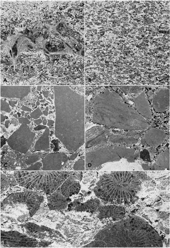
The lithologic description of the Salem Limestone is taken from cores from Comanche, Ford, Scott, Logan, and Lane counties. In Comanche County, the Salem consists of semicrinoidal limestone with thin oolitic beds. The Salem in Ford County is a calcarenite containing quartz sand and glauconite. In Scott County, in the deeper part of the Hugoton embayment, the Salem consists of a variety of lithologies including calcarenite, fossiliferous limestone, and dolomite with sparse chert. Uncrushed bryozoan fronds are preserved in oolitic limestone (Fig. 5, 4), and shallower beds contain calcarenite (Fig. 5, B). Part of the Salem in Logan County is dolomite with calcite-filled "fossil-casts." Crystalline limestone makes up part of the Salem in Lane County. The amount of residue from the Salem Limestone is a small proportion of the original rock.
Figure 5--Negative peel-prints (X3) prepared from polished core slabs of Salem Limestone (A and B) an(] St. Louis Limestone (C-E) (Atlantic Oil Co. No. 1-A Mark; Core C, Table I), Scott County, Kansas. A, Salem Limestone (5,026 feet); bed of oolitic limestone with lens containing well preserved fenestrate bryozoan fronds. B, Salem Limestone (4,983 feet); bed of poorly sorted biocalcarenite exhibiting lineation of grains. C, St. Louis Limestone (4,898 feet); bed of chert breccia in groundmass of silty calcareous shale. Fragments consist of gray, semi-opaque ordinary chert. Residues contain silicified fossil fragments. D, St. Louis Limestone (4,862 feet); bed of limestone breccia containing subangular fragments of fine-grained limestone in groundmass of calcareous silty shale with sparse fine frosted sand grains. E, St. Louis Limestone (4,812 feet); bed of coralline limestone (Lithostrotion proliferum) in fine-grained calcareous groundmass.
Thickness, distribution, and stratigraphic relationships
The Salem unconformably underlies the Pennsylvanian in places (Fig. 3). The formation increases in thickness southward from 0 feet along the outline of the Pennsylvanian subcrop pattern to more than 200 feet in the Hugoton embayment. The small amount of Salem present is attributed in great part to exposure and erosion in late Mississippian and early Pennsylvanian time. The Salem is present and conformable beneath the St. Louis throughout much of southwestern Kansas, generally thickening basinward into the Oklahoma Panhandle. The Salem is conformable upon the Warsaw. It is about 50 feet thick in the deepest part of the Salina and Forest City basins.
The Salem is mapped beneath the St. Louis in southeastern Barber County and western Harper County. This is the first report of Salem in the Sedgwick basin. Warsaw, Salem, and St. Louis equivalents are probably widespread in the southern portion of the Sedgwick basin but have not been recognized because of the "Cowley facies" and because either the chert residuum of the "Mississippi chat" or chertified rocks conceal them. A thin section of Salem rocks is reported in Woodson County in eastern Kansas (Cores N and O).
St. Louis Limestone
Outcrops
The St. Louis Limestone was named by Engelmann (1847) for exposures at St. Louis, Missouri. In the type area, the formation is a gray, lithographic to finely crystalline limestone. Spreng (1961) reported that limestone breccia is common in, but is not confined to, the lower part. Lithostrotion proliferum (Hall) and Lithostrotionella castelnaui (Hayasaka) are compound corals that are diagnostic of the formation.
Subsurface character
Lee (1943, p. 76) described the St. Louis Limestone in the Forest City basin as a lithographic to sublithographic limestone interstratified with semigranular limestone that has oolitic beds in some localities. The preservation there of part of a once-widespread formation is attributed to its protection from erosion in a post-Mississippian basin.
Westward, on the basis of the absence of lithographic limestone in the interval above the Salem Limestone in wells in the Salina basin, Lee (1956, p. 85) assigned the total thickness of post-Warsaw rocks to the Salem, even though the total thickness in one well (Auto Ordnance-Darby No. 1 Gawith, sec. 27, T 11 S, R 5 W) was double the average thickness of the Salem in that basin. Lee (1940) included the St. Louis of western Kansas in the Watchorn Formation, but did not identify St. Louis or Watchorn in south-central or southeastern Kansas.
The St. Louis Limestone in western Kansas is thought to be conformable with Meramecian rocks above and below it. The beds are characteristically noncherty, lithographic and sublithographic limestone, but also include remarkably widespread oolitic limestone and calcarenite. Semigranular limestone containing traces of translucent chert is found in some wells. In the deeper part of the Hugoton embayment the St. Louis contains coarsely crystalline limestone and dolomitic limestone. The upper part of the St. Louis is arenaceous and light colored; sand grains generally are larger than in the overlying Ste. Genevieve Limestone. Chert, which occurs sparingly in the upper part in some wells, is light colored, smooth, and semiopaque. The dolomite in the lower part is saccharoidal in texture; a few embedded sand grains were observed, and fewer oolitic beds are present. This portion of the St. Louis tends to be darker colored (tan or brown) than the upper portion.
In a study of a limited area in southwestern Kansas, Lee (1953) observed that the absence of silty limestone differentiated the St. Louis from the Ste. Genevieve. Clair described the oolites in the coarsely oolitic, dense St. Louis Limestone in western Kansas as very large and spherical [Clair, J. R., 1948, Preliminary notes on lithologic criteria for identificatiobn and subdivision of the Mississippian rocks in western Kansas: Kansas Geol. Soc., Wichita, p. 1-14. (Mimeographed report.)]. Clair observed an abundance of large free oolites where the matrix was coarsely crystalline. Where the St. Louis is a finely oolitic limestone, he reported that the oolites are nearly the same color as the matrix and spherical. He distinguished the Ste. Genevieve from the St. Louis on the basis of very tiny, elliptical oolites, all darker than the containing matrix. These lithologic criteria were not found useful in our study of cores of the St. Louis Limestone.
Hundhausen (in Lee, 1940, p. 83), using hydrochloric acid residues, subdivided rocks of Meramecian age encountered in the Spangler well in Scott County (sec. 23, T 20 S, R 33 W) into Warsaw, Spergen, and St. Louis. Girty 1940, p. 84) said the Spangler well contained ". . . fossils definitely identified . . . as St. Louis although no limits were set"--fossils indicative of age equivalents of late Meramecian time. The residues were reported by Lee as being small in quantity and consisting mainly of gray translucent silica enclosing gray, opaque fossil fragments.
Core and residue data
The lithology of the St. Louis Limestone is variable. In Scott County, the St. Louis contains beds of oolitic, stylolitic, arenaceous limestone and calcarenite with shale partings occurring throughout. Generally, the characteristics of the St. Louis in Scott County are common to the formation in western Kansas. Beds of limestone breccia, limestone conglomerate, and chert breccia have developed locally in the St. Louis (Fig. 5, C, D) providing evidence of intraformational erosion in the Hugoton embayment. Corals similar to those reported in the type area of the St. Louis (Lithostrotion proliferum) are preserved in Scott County (Fig. 5, E).
Thin section examination of limestone (Fig. 6, A-D) from the St. Louis reveals fragments of echinoderms, brachiopods, bryozoans, and foraminifers as skeletal elements of the calcarenites. Endothyra, common in the underlying Salem Limestone, is also found in the St. Louis Limestone.
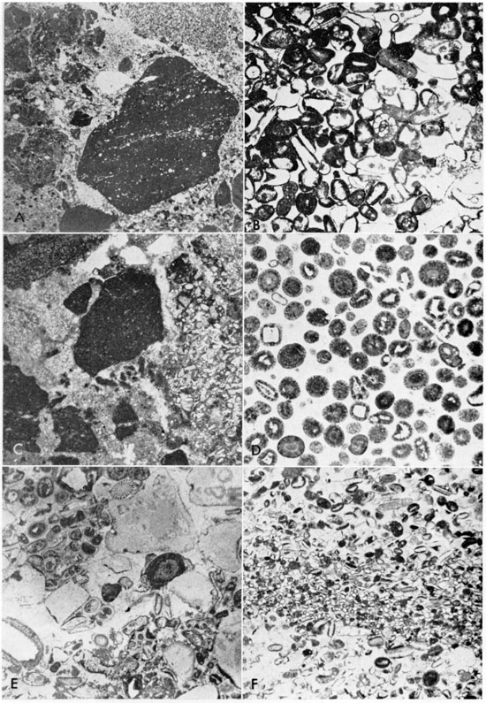
Figure 6--Photomicrographs of core slabs and chips from the St. Louis Limestone (A-D) and the Ste. Genevieve Limestone (E and F) from western Kansas. A, St. Louis Limestone, Logan County (Core D, Table 1, 4,576 feet); conglomerate containing lithiclasts of "mixed-fossil" lime mudstone in quartzose "mixed-fossil" lime groundmass, X3. Skeletal fragments of echinoderms, bryozoans, brachiopods, and foraminifers and pellets and fine-grained quartz sand. B, St. Louis Limestone, Finney County (McKnab Lindsay No. 7 Kuhn-Devlin, sec. 19, T 26 S, R 34 W, 5,138-5,149 feet); oolitic calcarenite with skeletal fragments of echinoderms, foraminifers (Endothyra, center of photo), bryozoans, and brachiopods in calcite spar, X15.6. Ooliths exhibit overgrowths reflecting shape of nuclei. Evidence of pressure solution displayed by concavo-convex relationships of grains and ooliths. C, St. Louis Limestone, Haskell County (Helmerich and Payne No. 1 Eubank, sec. 28, T 28 S, R 34 W, 5,642 feet); quasi-brecciated micrite in which mud blebs are separated by silty, calcareous spar, and "mixed-fossil" lime mudstone, x15.6. D, St. Louis Limestone, Haskell County (No. 1 Eubank, 5,514 feet); (oolitic limestone in groundmass of spar; no free skeletal grains, but skeletal fragments make up nuclei of ooliths. Little pressure solution but significant recrystallization as shown by spar stringer transecting oolites in upper right quadrant, X15.6. E, Ste. Genevieve Limestone, Haskell County (No. 1 Eubank, 5,447 feet); oolitic calcarenite (60 percent grains), made up of skeletal fragments of echinoderms, brachiopods, bryozoans, foraminifers, and gastropods, X15.6. Irregularly ellipsoidal to spherical-shaped oolites display concentric structure and are fine to coarse sand size. F, Ste. Genevieve Limestone, Haskell County (Core B, 5,613 feet), fine- to medium-grained calcarenite; grains mostly skeletal fragments of echinoderms, brachiopods, and bryozoans in sparry calcite groundmass, X15.6.
Beds of anhydrite were logged in the St. Louis Limestone of Stevens and Hamilton counties. This occurrence was verified from core chips of the Mobil No. 1 Cunningham Est. (Core A) and No. 1 Alden Foster (sec. 5, T 34 S, R 36 W).
The St. Louis contains more interbedded shale in Comanche County than it does farther west. To the east, in Barber and Harper counties, the "Cowley facies" of the St. Louis is developed (Cores J and L). To the northwest in Gove County, the St. Louis contains quasibrecciated, fossiliferous and sparsely cherty limestone (Thompson and Goebel, 1963).
Mineral and rock residues from cores from the St. Louis Limestone generally constitute less than 5 percent by weight and consist of shale, silicified fossil fragments, chert, conodonts, and trace amounts of pyrite and sphalerite. Some residues contained a few small quartz grains.
Thickness, distribution, and stratigraphic relationships
The St. Louis Limestone in Kansas thickens from an erosional edge below the Pennsylvanian rocks to more than 250 feet in the deeper parts of the Hugoton embayment where it averages about 200 feet in thickness. It has not been recognized in the Salina basin (Fig. 3). Maximum thickness in the Forest City basin is about 50 feet. It is present in the Cherokee basin in Woodson and Greenwood counties.
The St. Louis Limestone is conformable above the Salem and below the Ste. Genevieve, except locally, where the Ste. Genevieve was removed and the St. Louis is overlain by Chesteran rocks. Where younger Meramecian rocks have been removed by early Pennsylvanian erosion, the St. Louis is unconformable beneath Pennsylvanian rocks. The St. Louis Limestone probably covered most of Kansas at one time. Lee (1956, p. 83) mapped St. Louis in the Forest City basin and stated that although neither the St. Louis nor the Ste. Genevieve have been recognized in the Salina Basin, they were probably deposited and subsequently removed by early Pennsylvanian erosion. Occurrence of beds of limestone breccia, limestone conglomerate, chert breccia, and anhydrite within the St. Louis Limestone in western Kansas indicates intraformational erosion and seemingly separates a younger conodont zone from an older conodont zone. The intraformational erosion also marks the first important occurrence of quartz clastic material as sediment in Meramecian rocks.
Ste. Genevieve Limestone
Outcrops
The Ste. Genevieve Limestone was named from Ste. Genevieve, Missouri, by Shumard (1860). It is typically developed in Ste. Genevieve and St. Louis counties in east-central Missouri (Spreng, 1961, p. 70). A locally developed basal conglomerate marks a disconformity above the St. Louis Limestone. Pre-Chesteran erosion removed some of the upper Ste. Genevieve beds.
Subsurface character
Lee (1943, p. 77) described the Ste. Genevieve in northeastern Kansas as gray to white, finely granular to "mealy," oolitic limestone that contains 10 to 20 percent broken, angular, fine-grained quartz sand. He believed the Ste. Genevieve was conformable on the St. Louis in northeastern Kansas. The Ste. Genevieve is absent in the Salina basin in north-central Kansas (Lee, 1956).
The Ste. Genevieve in western Kansas is a silty and sandy, light-colored limestone, with interbedded fine-textured oolitic limestone. Some medium- and coarse-grained oolites occur in the lower part of the Ste. Genevieve. Beds of Ste. Genevieve strata cannot be positively identified where they overlie the finely oolitic limestone of the St. Louis. The shape of oolites which Clair used as a criterion was not found useful in distinguishing the Ste. Genevieve from the St. Louis [Clair, J. R., 1948, Preliminary notes on lithologic criteria for identificatiobn and subdivision of the Mississippian rocks in western Kansas: Kansas Geol. Soc., Wichita, p. 1-14. (Mimeographed report.)]. The criterion of a larger percentage of sand (up to 30 percent) in the limestones of the Ste. Genevieve is useful in some areas. Minor quantities of pink chert occur locally. Fragments of megafossils are scarce in drill cuttings.
Core and residue data
Cores from the Ste. Genevieve Limestone in Logan County include siltstone and calcarenite in wavy-bedded shale. Well-rounded sand grains are present in the matrix. Cores from Scott, Haskell, (Fig. 6, E, F), and Kearny counties contain similar rocks. Residues range from more than 65 percent to less than I percent insoluble and consist of shale, silt, quartz sand, pyrite, and chert.
Thickness, distribution, and stratigraphic relationships
The Ste. Genevieve Limestone in Kansas is more than 200 feet thick in the deeper part of the Hugoton embayment. It thins northward and eastward to 0 feet. The Ste. Genevieve Limestone locally is disconformable beneath Chesteran rocks, unconformable beneath Pennsylvanian rocks, and is seemingly conformable on the St. Louis Limestone. Locally in western Kansas it has been removed by pre-Chesteran erosion. The Ste. Genevieve is about 30 feet thick in Doniphan and Atchison counties in northeastern Kansas. Ste. Genevieve rocks have not been recognized in the Salina or Sedgwick basins (Lee, 1956), but at some time may have extended throughout Kansas. Because of regression of the late Meramecian sea, distribution of Ste. Genevieve rocks was more limited than older Meramecian units.
Residue Analyses
Chert is considerably less common in Meramecian than in Osagian rocks. Generally, chert from Meramecian rocks is concentrated in the Warsaw, and the microfossil content is higher than in Osagian chert. Chert generally decreases upward in Meramecian rocks and is a minor constituent in the Ste. Genevieve Limestone.
Glauconite in Meramecian rocks seemingly decreases upward. It is locally concentrated in the lower part of the Warsaw. Traces of glauconite are common in many of the residues.
Traces of pyrite, sphalerite, chalcopyrite, and galena indicate secondary sulfide mineralization. Anhydrite is present as fracture fillings. Pyrite is a common residue. In general sulfide minerals are less abundant in the residues from Meramecian rocks than from Osagian rocks.
Generally, smaller quantities of clay-sized particles from Meramecian rocks were washed away through the 100-mesh screen during laboratory procedures than the quantities discarded from Osagian cores. This lesser clay content is obvious from visual inspection of Osagian and Meramecian rock cores.
Insoluble (hydrochloric acid) residues from exposed Meramecian rocks have been found useful in Missouri in identifying laterally equivalent units in some restricted areas (Grohskopf and McCracken, 1949). Lee (1940, 1949, 1953, 1956) used some of these gross residue characteristics in conjunction with sample examination to extend Meramecian units into Kansas. Some of these gross residue and sample characteristics have been found unsatisfactory when applied to western Kansas Meramecian rocks. Of these, color, texture, and transparency of cherts are thought to be locally controlled and to be of little use in mapping, even within a basin. Use of these local characteristics, however, may be feasible within one oil field where boreholes are closely spaced.
Recovery of fragments of silicified and partly silicified fossils as residue material from Meramecian rocks is common. Additional study of these fragments and of megafossils in cores is suggested and should yield information on the environment of deposition, the diagenesis, and the age of the rocks.
Environment of Deposition and Diagenesis
Meramecian rocks, including the part of the section from the Warsaw Limestone into the St. Louis Limestone, were deposited in an environment similar to that in existence during Osagian and part of Kinderhookian time (Goebel, 1966). Shallow, warm, clear, epicontinental seas of marine salinity covered most of the central and western interior of the United States during most of this time. The main source of sediment was biogenic, including skeletal material of pelagic and benthonic invertebrate animals in great variety, especially corals, brachiopods, bryozoans, foraminifers, gastropods, conodonts, and scolecodonts. Fish remains and sharks' teeth are also preserved. Platform or shelflike conditions typify the environment of deposition. Sands and shales make up only a minor part of the preserved section of rocks below about the upper half of the St. Louis Limestone.
A great variation in lithology was revealed in study of photographs and acetate peel-prints of Meramecian cores (Fig. 4-6). The lithologies include fine-grained lime mud, pelletoid and oolitic limestone, calcareous dolomite, calcarenite, conglomerate, and brecciated limestone. These indicate changing depositional environments.
The water was probably well agitated at times, as attested to by the presence of crossbedding in some of the Meramecian rocks. Widespread development of oolites and beds of calcarenite may be interpreted as indicating intermittent current action sustained over a long period of time in shallow and restricted seas. The lime muds probably indicate protected areas with a low level of current action.
Downwarping, coupled with accumulation of mixed-fossil and oolitic limestone beds, could account for the basinward thickening of shelf deposits. Widespread distribution of oolitic limestone beds reflects shifting of areas of accumulation or environments of deposition in time and space.
Thinly laminated glauconite in some oolitic beds may indicate shallow-water deposition. Bedded anhydrite in the St. Louis Limestone is probably indicative of local deposition in a closed or shallowing basin. Anhydrite precipitation probably occurred with progressive shallowing of waters and restriction of circulation caused by a drop of sea level or by maintenance of static sea level relative to the building up of shoals.
Diagenetic changes in Meramecian rocks are shown by the presence of sulfide minerals, dolomitized rocks and fossils, siliceous fossil fragments, and probably by chertified rocks. Molds of calcareous fossils in dolomite attest to the dolomitization of some limestone beds. Dolomitization locally destroyed much of the original texture of some of the limestone beds and fossils. Relict textures in dolomite indicate that the original rock in some places was fine- to coarse-grained fossiliferous limestone.
Bedded anhydrite and breccia and conglomerate within the St. Louis Limestone reflect a change in regimen of the Meramecian sea in western Kansas. The environment of deposition of Meramecian rocks definitely changed at the time of the deposition of the Ste. Genevieve Limestone, which is characteristically arenaceous. Quartz sand and silt became important constituents of the sediments at this time and increased in importance throughout Chesteran and into Pennsylvanian time.
It is doubtful that Ste. Genevieve rocks covered all of Kansas. Probably the Central Kansas uplift and the Nemaha anticline areas during late Meramecian time contributed important quantities of terrigenous material to the clastic and detrital content of sediments in adjoining basins of deposition. And probably at this time, rocks in the area of these upwarpings and areas of provenance included older Mississippian rocks, which had a high chert and silicified fossil content, and arenaceous pre-Mississippian rocks.
Prev Page--Introduction || Next Page--Conodont fauna
Kansas Geological Survey, Geology
Placed on web June 24, 2010; originally published Dec. 1968.
Comments to webadmin@kgs.ku.edu
The URL for this page is http://www.kgs.ku.edu/Publications/Bulletins/192/03_mera.html