![]()
Previous Page--Mississippian || Next Page--Permian
PENNSYLVANIAN SYSTEM
By John Mark Jewett, Howard G. O'Connor, and Doris E. Zeller
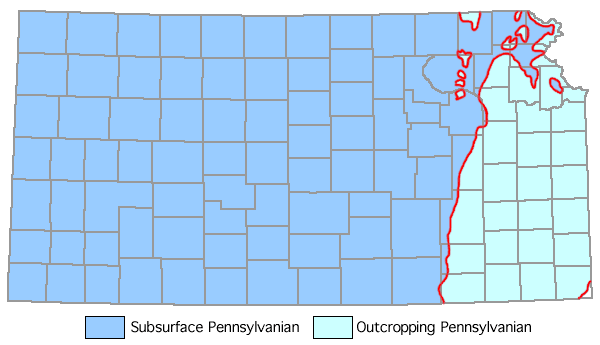
This division of rocks of late Paleozoic age is widely represented throughout the world, being distinguished by coal deposits and by abundant marine invertebrates and land plants. Pennsylvanian outcrops are widespread in eastern Kansas (Fig. 7), and these serve as a standard of reference in the study of deposits of equivalent age in other parts of the Continent. The system in Kansas is divided into a Lower, Middle, and Upper Pennsylvanian Series (Pl. 1). Pennsylvanian rocks comprise five stages, in ascending order: Morrowan, Atokan, Desmoinesian, Missourian, and Virgilian. Rocks of Morrowan age (Lower Pennsylvanian) are thought to be restricted to the Hugoton embayment. Possibly some Atokan rocks are present in northeastern Kansas. The cyclic nature of the Desmoinesian (Middle Pennsylvanian) and younger Pennsylvanian deposits is striking. The cycles consist of marine shales and limestones alternating with nonmarine beds. The aggregate thickness of exposed stratigraphic units belonging to the Pennsylvanian System in Kansas is about 3,100 feet. Outcrops occur throughout the eastern one-third of the State (State Geol. Survey Kansas, 1964).
Figure 7--Distribution of Pennsylvanian rocks in Kansas. Area in white in southeast corner of State is outcropping Mississippian (adapted from Moore et al., 1951; State Geol. Survey Kansas, 1964).
At the outcrop, the Pennsylvanian strata have a gentle west or west-northwestward dip of from 15 to 35 feet per mile. Locally, there are dips in other directions, or the beds may be horizontal; nowhere are the strata steeply inclined. A belt of distinct, though gentle, eastward dips may be traced across the State from the vicinity of Arkansas City (Cowley County) in the south to the neighborhood of Seneca (Nemaha County) in the north; this defines the east limb of the buried Nemaha anticline.
All stage and group divisions of the outcropping Pennsylvanian succession have been traced westward in the subsurface to the Colorado state line, although some minor units thin or become indistinguishable locally (Merriam, 1963). Northward thinning of shale formations and members, as seen in outcrops, has its counterpart in westward thinning of shales in the subsurface. Some limestones also become thinner and wedge out westward, but they are more persistent than the shales. In western Kansas, Pennsylvanian rocks above the Atokan Stage consist mainly of limestones separated by shale beds. As along outcrops, most shales in the subsurface thicken southward toward the Oklahoma border, and many limestones disappear or grade into shale or sandstone in this direction.
Pennsylvanian rocks in Kansas are conformable with overlying Permian rocks but unconformable on Mississippian and older Paleozoic rocks. The "Pennsylvanian basal conglomerate" is a good subsurface marker bed outside the Hugoton embayment (Fig. 6). It is best developed where underlying Mississippian and older rocks are cherty limestones and dolomites. The conglomerate is composed of cobbles and pebbles of cherty limestone in a matrix of finer-grained detrital material. The genesis of the conglomerate is discussed by Lee (1939, p. 10).
Although the thickness of the Pennsylvanian rocks increases southwestward, the regularity is modified by local structural features developed by differential movements during Pennsylvanian time. Before earliest Pennsylvanian sedimentation in Kansas, the eroded surface of Mississippian and older rocks was deformed by renewed uplift of the Nemaha anticline, the Central Kansas uplift, and some minor structures (Fig. 2). Parts of the Central Kansas uplift were not covered by Pennsylvanian sediments until late Pennsylvanian time. The differential structural movements that took place in this region are revealed by gradual thinning of all Pennsylvanian units above the Desmoinesian over the crests of anticlines. Most major Pennsylvanian units are thicker in the Hugoton embayment than elsewhere in Kansas.
Lower Pennsylvanian Series
Lower Pennsylvanian rocks are present only in the subsurface of western Kansas in the Hugoton embayment. They are overlain unconformably and overlapped in western Kansas by rocks of Middle Pennsylvanian age.
MORROWAN STAGE
Rocks of the Morrowan Stage seemingly are unconformable upon Chesteran and older rocks. They comprise 600 feet of shale, limestone, and sandstone.
KEARNY FORMATION
Rocks of Morrowan age were first reported by M. L. Thompson (1944, p. 414) who named the Kearny Formation "…for the 127 feet of rocks encountered between…4,752 feet and the top of the highly oolitic limestone believed to be of Mississippian age at a depth of 4,879 feet in the Stanolind Oil and Gas Company No. 1 Patterson well." He assigned a Morrowan age on the basis of the fusulinid Millerella. The lithology of a thick section of marine sandstone, shale, and limestone was described by McManus (1959). Additional data on the lithology and distribution are known from work by Moore (1949), Maher and Collins (1952, 1953), Beebe (1957), and Rascoe (1962). McManus (1959) expanded the definition of the Kearny to include beds up to the base of the Atokan. He described a lower shale unit including many sandstone and limestone beds and an upper shale unit containing fewer beds of limestone and sandstone. The thickness of the two units ranges from 0 to 600 feet. The lower unit ranges from 0 to 250 feet, thickens to the southwest, and is overlapped northward and eastward in western Kansas by the upper shale unit. The upper unit (from 0 to 350 feet thick) also demonstrates a southward thickening in western Kansas. There the Kearny overlaps progressively older Mississippian rocks to the north, and thins northward and eastward. The unconformity at the base of the Kearny is obscure where this unit lies on upper Chesteran rocks. The upper boundary arbitrarily is placed just below a persistent coal bed (Atokan).
Middle Pennsylvanian Series
Rocks of the Atokan Stage are gradational with rocks of the Desmoinesian Stage in western Kansas. The Atokan is absent in central Kansas, but it may be present in northeastern Kansas. Rocks of the Desmoinesian Stage are widespread.
ATOKAN STAGE
Rocks of this sequence are mainly interbedded dark-gray, black, and dark-brown, cherty limestones and dark-gray to black shales. Near the base a few fine-grained sandstones occur locally. Fusulinids of Atokan age have been reported by M. L. Thompson (1944) and McManus (1959). McManus reported a gradational contact between Atokan and Desmoinesian rocks in the deeper parts of the Hugoton embayment. Atokan rocks overlap Morrowan rocks locally in southwestern Kansas. The Atokan rocks are from 0 to 500 feet in thickness. At the base of the Atokan there is commonly a well-developed coal bed.
In northeastern Kansas, on the basis of identification of Atokan rocks in adjacent northwestern Missouri (Searight and Howe, 1961), it seems probable that pre-Desmoinesian (Atokan) rocks are preserved.
DESMOINESIAN STAGE
The lowermost major division of Pennsylvanian rocks that crop out in Kansas is the Desmoinesian Stage. Desmoinesian rocks occupy the stratigraphic interval between important regional unconformities. These deposits are set off from rocks of the overlying Missourian Stage by pronounced paleontologic and lithologic differences. Rocks of the Cherokee and Marmaton groups are 600 to 750 feet in outcrop thickness.
Cherokee Group
The Cherokee Group includes both marine and nonmarine rocks lying between the base of the Fort Scott (Marmaton Group) and the Mississippian. Much sandstone and sandy shale and the most important coal beds in the State are in this group. Little limestone is present. The group is not divisible readily into mappable units comparable in thickness to those found in the Upper Pennsylvanian Series. The thickness on the outcrop ranges from 350 to 500 feet. In outcrops in southeastern Kansas the group contains two formations.
Rocks in the Cherokee Group, in an earlier stratigraphic summary (Moore et al., 1951), were classified on the basis of cyclothems. In later detailed stratigraphic studies, Howe (1956) subdivided the Cherokee Group into the Krebs Subgroup and Cabaniss Subgroup, which together contained eighteen formations. Rocks from the top of one coal bed to the top of the next overlying coal bed were classed as a formation, and the formation was given the same geographic name as one of the included coal, limestone, or sandstone beds. Practical mapping considerations led Jewett (1959) to change the Krebs and Cabaniss subgroups to units of formational rank. Jewett retained only the previously named coal beds, limestones, and sandstones as subdivisions of the two formations.
The named members and beds in the Krebs and Cabaniss formations (Pl. 1) are restricted herein to those units that conform with the rules of the Code of Stratigraphic Nomenclature (American Comm. Strat. Nomenclature, 1961) and application of identical geographic names to more than one lithologic unit is avoided. Although light- and dark-colored shales predominate in the Krebs and Cabaniss formations, none of the shales have been named. In the subsurface the Cherokee Group generally is not divisible into formations.
KREBS FORMATION
The Krebs Formation comprises strata, principally shale, but including sandstone, limestone, underclay, and coal, lying above rocks of Atokan age and below the top of the Seville(?) Limestone Member. For practical purposes, because the Seville(?) Member is absent in most places, the top of the Bluejacket Sandstone Member may be regarded as the upper boundary of the formation (Howe, 1956, p. 27). The thickness of the Krebs is 200-250 feet.
The Riverton coal bed is the lowermost named unit in the Krebs Formation. It overlies about 10 feet of shale and underclay and underlies the Warner Sandstone Member. The thickness is generally less than 1 foot.
Warner Sandstone Member
This member is a fine- to medium-grained gray to brown quartzose sandstone, 10 to 25 feet thick, which overlies the Riverton coal bed. The member is overlain by about 50 feet of dark shales and several thin beds of argillaceous limestone. It is commonly asphaltic in outcrops. This unit was formerly called the "Little Cabin sandstone" (Howe, 1956, p. 33).
The Neutral coal bed (Howe, 1956, p. 34), which is about 0.5-foot thick, lies about 10 feet below the Rowe coal bed. It has a fossiliferous limestone "cap rock."
The Rowe coal bed (formerly Columbus) occurs several feet below the Dry Wood coal and is commercially the most important coal in the Krebs Formation. Locally a fossiliferous limestone occurs next above the coal. Thickness of the coal bed ranges from about 0.8-foot to 1.7 feet (Howe, 1956, p. 37).
Irregular in thickness, the Dry Wood coal bed commonly is found a few feet below the Bluejacket Sandstone Member. Its thickness is from 0 to about 1.7 feet.
Bluejacket Sandstone Member
This sandstone lies near the top of the Krebs Formation. A thin underclay and coal, and locally the Seville(?) Limestone Member, overlie it. The Bluejacket consists of fine- to medium-grained, micaceous, angular to subangular quartzose sandstone, with minor amounts of silt, and it is conglomeratic in the basal part. Its thickness on the outcrop is 10 to 40 feet.
Seville(?) Limestone Member
A limestone tentatively correlated with the Seville Limestone of Illinois (Howe, 1956, p. 44) occurs locally in eastern Crawford County. It is a fossiliferous, argillaceous, slabby-weathering rock. The thickness is about 0.5 foot.
CABANISS FORMATION
The Cabaniss Formation, principally shale, but containing some sandstone, limestone, and coal, lies below the Fort Scott Limestone and above the Seville(?) Limestone Member. The thickness is about 220 feet.
The Weir-Pittsburg coal bed is commercially the most important coal bed in Kansas. Characteristically there is a thin parting of clay a few inches above the base. A few feet of shale and underclay generally occur below the Weir-Pittsburg coal and above the Seville(?) Limestone Member. The average thickness of the Weir-Pittsburg is about 3.6 feet.
The Tebo coal bed (Howe, 1956, p. 51), which is about 0.5-foot thick, generally occurs 15-20 feet above the Weir-Pittsburg coal bed. The Tebo was formerly called the "Pilot" coal.
The Tiawah limestone bed is a thin, discontinuous limestone above the Tebo coal bed and several feet below the Scammon coal bed (Howe, 1956, p. 54). It is abundantly fossiliferous, containing gastropods and brachiopods. The Tiawah averages 0.3-foot in thickness.
Chelsea Sandstone Member
This member is a gray to brown, fine-grained, micaceous sandstone, which is locally conglomeratic (Howe, 1956). The maximum thickness is about 30 feet.
The Scammon coal bed is separated from the Mineral, above, by about 16 feet of underclay, sandy and silty shale, and a thin, discontinuous limestone. The thickness of the Scammon is about 0.7 foot.
The Mineral coal bed is about 1.5 to 2.0 feet in thickness. Strata, chiefly shale and underclay about 15 to 20 feet thick, are present between the Mineral coal bed and the overlying Fleming coal bed. The "Robinson Branch coal bed," in one place in Cherokee County, occurs between the Mineral and the Fleming coals.
The Fleming coal bed is separated from the Croweburg by about 20-25 feet of underclay, sandstone, and shale. The thickness is a fraction of an inch to about 2 feet.
The Croweburg coal bed is one of the most persistent beds in the Cherokee Group, occurring a few feet below the Verdigris Limestone Member. It is reported to be the equivalent of the Whitebreast coal in Iowa and the Broken Arrow coal in Oklahoma (Howe, 1956). The thickness is commonly 0.8 foot to 1.3 feet. About 5 feet of light-gray and dark-gray shale lies between the Croweburg and the Verdigris Limestone Member.
Verdigris Limestone Member
This is the most easily identified "marker bed" in the Cherokee Group, occurring just below the underclay of the Bevier coal bed in most of its outcrop area. In Labette County it is separated from the Bevier by several feet of underclay, sandstone, and shale. The Verdigris is chiefly dark-gray, foraminiferal limestone. This unit has also been called the "Ardmore limestone" (Searight et al., 1953). The thickness is about 2 feet.
The Bevier is a bright, hard, blocky coal, containing pyrite and calcite. The thickness along most of its outcrop belt is about 1.3 to 2 feet.
The Bevier is separated from the overlying Breezy Hill Limestone Member by 60 to 70 feet of rocks, chiefly light-gray shale, but including dark-gray shale, sandstone, and underclay. This interval contains the "Squirrel sandstone" of the subsurface.
Breezy Hill Limestone Member
The Breezy Hill Limestone Member is commonly nodular, irregularly bedded, sandy, and conglomeratic. Near the Kansas-Oklahoma boundary, the member becomes thin-bedded to massive, dense, gray to brown limestone. The thickness ranges from about 2 to 16 feet.
The Mulky coal bed, about 1-foot thick, overlies the Breezy Hill and is separated from it by 2 to 4 feet of underclay. The Mulky is separated from the overlying Fort Scott Limestone by 2 to 5 feet of black, platy, concretion-bearing shale.
Marmaton Group
The upper part of Desmoinesian beds in Kansas, approximately 250 feet thick, is assigned to the Marmaton Group. These strata are more calcareous than those of the underlying Cherokee Group. Eight formations are recognized.
FORT SCOTT LIMESTONE
This formation comprises two limestones and an intervening shale member. Characteristic thickness is about 33 feet.
Blackjack Creek Limestone Member
The Blackjack Creek Member is 4 to 17 feet thick. The lower part of the member is about 2 feet of sparsely fossiliferous brownish-gray limestone that weathers brown. The upper part of the member is a light-gray, coarsely crystalline, irregularly bedded Chaetetes-bearing limestone.
Little Osage Shale Member
Black platy shale containing small phosphatic concretions and gray clayey calcareous shale, coal, and limestone makes up the Little Osage Member. The lower part commonly is black and platy and the upper part is generally light gray and calcareous. A persistent, thin bed of granular limestone that occurs a few inches to 2 or more feet below the Higginsville Limestone Member may be equivalent to the Houx Member of Missouri. The Summit coal bed, which is persistent from northern Crawford County northeastward into Missouri, occurs in the upper middle part of the Little Osage Shale. Thickness of the member ranges from 4 to 12 feet.
Higginsville Limestone Member
The Higginsville Limestone Member is chiefly light-gray, thin-bedded to massive limestone characterized by scattered unusually large crinoid stems, irregular distribution of small to large fusulinids, and isolated colonies of Chaetetes. Locally the upper part is composed entirely of Chaetetes. Average thickness is 15 feet.
LABETTE SHALE
The Labette Shale consists of gray and yellow clay shale, sandy shale, and sandstone, coal, and limestone beds. Near the top is a persistent limestone believed to be the Wymer City Limestone of Oklahoma. A black shale and a coal bed are present in the basal part. Black shale occurs locally in the upper part. Some sections contain several thin limestone and coal beds. A limestone bed 1- to 2-feet thick occurs in the middle lower part. Thickness ranges from about 30 to 100 feet.
Englevale Sandstone Member
This is one of several bodies of sandstone lying in the middle and lower parts of the Labette Shale. The Englevale locally fills channels eroded into the Fort Scott Limestone. It is the "Peru sand" of the subsurface. The average thickness is about 30 feet.
PAWNEE LIMESTONE
The lower part of the Pawnee Limestone consists of shale and a thin, nonpersistent basal limestone. The upper, main part of the Pawnee formation comprises two persistent limestone members separated by a shale member. The thickness ranges from about 15 to 60 feet.
Anna Shale Member
This member is a black, platy, locally fissile, shale, with lenses of dark, slabby, crystalline, locally crinoidal limestone in the basal part. A few inches of gray shale occur near the top in some places; small phosphatic concretions are common. Thickness ranges from 2 to 5 feet.
Myrick Station Limestone Member
The Myrick Station Limestone Member is a dark-gray, brown, and light-gray limestone. The lower part, comprising about 2 feet of massive dark-gray, brown-weathering limestone, is most persistent, and this is overlain locally by a lighter-colored Chaetetes-bearing limestone. The thickness ranges from 2 to about 8.5 feet.
Mine Creek Shale Member
The Mine Creek Shale Member is a light-gray to black shale, flaky, platy and fissile, locally containing one or more thin limestone beds in the middle part. It contains abundant brachiopods and a few corals. This member is thin or absent in Labette County. The thickness ranges from 0 to 15 feet.
Laberdie Limestone Member
The Laberdie is a light-gray, crystalline, Chaetetes-beaiing limestone that occurs in thin wavy beds or beds of irregular thickness. The lower part is somewhat more massive. The member forms extensive dip slopes and caps prominent escarpments. Fusulinids and other marine fossils are plentiful locally. The Laberdie Limestone is the Coal City Member of Missouri and Iowa (Searight and Howe, 1961, p. 93). The thickness is about 10 to 20 feet.
BANDERA SHALE
The Bandera Shale is mainly nonmarine gray and yellow, mostly blocky claystone, well-bedded shale, and massive to thin-bedded sandstone. Maroon bands are present in the upper part. The formation contains limonitic concretions and veins and septarian limestone concretions locally. Plant fossils are found in the lower part of the sandy fades. The Mulberry coal is a persistent bed in the lower part of the Bandera north of Crawford County. Shale below the coal is light to dark gray and carbonaceous. Locally, a thin, dark-gray limestone lies just above the Mulberry coal. The thickness of the formation ranges from 20 to 50 feet.
Bandera Quarry Sandstone Member
This member is a gray and brown, thin-bedded sandstone. The thickness ranges from 0 to 30 feet. Where present, the Bandera Quarry sandstone occupies the middle or lower part of the Bandera Shale.
ALTAMONT LIMESTONE
The Altamont Limestone consists of two limestone members separated by a shale member. The lower limestone is most prominent in the southern part of the outcrop area in southeastern Kansas, and the upper limestone is most prominent in northern outcrops. The formation is absent locally in the subsurface of Miami County owing to pre-Missourian erosion. The average thickness is 19 feet.
Amoret Limestone Member
The Amoret Limestone, about 10 feet in thickness, is a light-gray, massive, Chaetetes-bearing, dense limestone, associated with two shale beds in the southern part of the outcrop area. In the northern part of the outcrop area the limestone, which is about 1 to 2 feet in thickness, is darker gray, more granular, and locally crossbedded.
Lake Neosho Shale Member
This member is a light- and dark-gray to nearly black shale with abundant phosphatic concretions containing fish teeth and bone fragments. The thickness is about 2 to 8 feet.
Worland Limestone Member
The Worland Member is a light-gray limestone, semilithographic in the upper part, the reaminder mostly crystalline, brecciated, and wavy-bedded. The Worland contains a few brachiopods and fusulinids, the latter locally abundant. Thickness commonly is about 8 feet.
NOWATA SHALE
The Nowata Shale contains gray to yellow clay shale, sandy shale, and sandstone; it is both marine and nonmarine. The formation is locally absent in the subsurface of Miami County, owing to pre-Missourian erosion. The thickness is 3 to 30 feet.
Walter Johnson Sandstone Member
The Walter Johnson is a thin-bedded to massive sandstone in the Nowata Shale occurring locally in southeastern Kansas. It is the "Wayside sand" of the subsurface. Outcrop thickness is commonly 4 to 10 feet.
LENAPAH LIMESTONE
This formation is made up of two limestone members separated by a shale member and is locally thin or absent as a result of pre-Missourian erosion. The lower two members are absent in some places. Thickness ranges from 1 to 18 feet.
Norfleet Limestone Member
The Norfleet Limestone Member is a dark brownish-gray, massive to bluish-gray, slabby limestone. The Norfleet resembles local facies of the Idenbro Limestone Member in some northern outcrops. South of the Kansas-Oklahoma line, the Norfleet grades into massive, dense limestone that is continuous with the overlying nodular limestone facies of the Perry Farm Shale Member. The thickness ranges from a few inches to about 3 feet.
Perry Farm Shale Member
The Perry Farm Member is a light- to dark-gray clay shale containing nodules of limestone. It grades laterally into nodular limestone south of the Kansas-Oklahoma line. Locally the shale is abundantly fossiliferous, brachiopods occurring in the upper part and a molluscan fauna in the middle and lower parts. The member is locally absent in the northern part of the outcrop area. The thickness ranges from 0 to about 20 feet.
Idenbro Limestone Member
The Idenbro Limestone Member is chiefly light-gray crystalline and pseudo-brecciated limestone. In Linn and Bourbon counties it is represented by brownish-gray to dark-gray limestone, mostly crystalline, but dense and earthy locally. This member forms low escarpments and broad dip slopes in the southern part of the outcrop area. The thickness in the northern part of the outcrop area is 1 to 2 feet; in the southern part it is 6 to 9 feet.
HOLDENVILLE SHALE
The Holdenville Shale (formerly Memorial shale) is a gray and yellowish-gray clay shale, generally unfossiliferous. In Labette County it comprises dark-gray shale that contains marine fossils including abundant Acaciapora austini and Mesolobus and contains two coal beds. The unit locally is absent owing to pre-Missourian erosion. The maximum known thickness is 30 feet.
Upper Pennsylvanian Series
Outcropping Upper Pennsylvanian rocks of Kansas aggregate nearly 1,800 feet of limestone, shale, and sandstone. These strata are cyclical in nature. The Upper Pennsylvanian Series is divided into two stages, the Missourian below, accounting for one-third of the section, and the Virgilian above, encompassing two-thirds of the section.
MISSOURIAN STAGE
Upper Pennsylvanian rocks in Kansas belonging to the Missourian Stage lie with seeming conformity below the base of sedimentary rocks assigned to the Virgilian Stage and above a regional disconformity that separates them from deposits of the Desmoinesian Stage. Missourian rocks are distinguished essentially by paleontologic characteristics and by some peculiarities of cyclic sedimentation. The outcrop area of these rocks in Kansas is a 20- to 40-mile-wide belt, marked by fairly prominent east-facing escarpments, extending from Doniphan County in the north to Montgomery County in the south (Fig. 1). The thickness averages about 650 feet.
Pleasanton Group
Rocks lying between the base of the Hertha Limestone and the disconformity that separates Missourian from Desmoinesian beds are mainly clastic sediments derived from land and deposited in shallow seas which advanced over Kansas after a time of more or less prolonged emergence. Gray, yellow, and dark-gray to black clay shale predominates, but there is much sandstone and some limestone and coal. The thickness ranges from about 30 feet to 135 feet (Jewett, Emery, and Hatcher, 1965). Three formations are recognized.
SEMINOLE FORMATION
In southeastern Kansas where the Checkerboard Limestone is identified, beds between the base of the Checkerboard and the disconformity at the base of the Pleasanton Group are assigned to the Seminole Formation. The thickness ranges from about 1 to 25 feet. Two members are recognized.
Hepler Sandstone Member
A persistent sheetlike deposit of brown and gray sandstone overlies the regional disconformity at the base of the Missourian Stage. A calcareous facies of the Hepler Sandstone is seen locally in southeastern Kansas. The thickness ranges from 2 to 25 feet, the thicker sections occurring toward the north.
South Mound Shale Member
This is a unit composed mostly of shale, which in southeastern Kansas contains coal and underclay (Jewett et al., 1965). Some marine fossils occur above the coal. The member is not recognized in Linn County and northward, where the upper boundary of the member cannot be identified. The thickness ranges from a few inches to about 8 feet.
CHECKERBOARD LIMESTONE
This formation is a gray limestone, locally containing a coquina of gastropods or crinoid fragments. Where thickest, this formation comprises two thin limestones separated by gray shale. The Checkerboard Limestone is an important marker in the Pennsylvanian strata of northeastern Oklahoma and is recognized in southern Kansas as far north as southern Neosho County. Possibly the Checkerboard equivalent (Exline Member) occurs in western Missouri and in nearby parts of central eastern Kansas. The thickness ranges from 0 to about 14 feet in Kansas (Jewett et al., 1965).
TACKET FORMATION
The Tacket Formation (Jewett et al., 1965) is a gray to yellowish-gray shale, locally containing much dark-gray to black shale, some flaggy, bluish-gray limestone, and massive sandstone. The base of the formation is at the top of the Checkerboard Limestone, where present, but in the northern part of the outcrop area the Tacket is in contact with the Hepler Sandstone, the basal member of the Seminole Formation. In Miami and Linn counties the interval is occupied chiefly by massive sandstone (Knobtown), which locally is as much as 25 feet thick. In southern Linn and northern Bourbon counties, thin beds of dense, bluish-gray limestone known informally as the "Bourbon flags" and alternating beds of dark-gray to black shale occupy the same interval and attain a thickness of 50 feet locally. Gray shale occurs in this position in southern Bourbon and northern Labette counties, but farther south there is much black, platy shale in this part of the section. The thickness ranges from about 15 to more than 60 feet.
Kansas City Group
The Kansas City Group includes strata from the base of the Hertha Limestone to the base of the Plattsburg Limestone. Three subgroups are recognized on the outcrop. The Kansas City Group is about 350 feet thick in the vicinity of Iola and about 325 feet thick in the Kansas City area.
In southern Montgomery County where the Swope Limestone and Hertha Limestone are absent, equivalent strata between the base of the Dennis Limestone (Kansas City Group) and the top of the Checkerboard Limestone (Pleasanton Group) are called the "Coffeyville Formation" (Pl. 1) and equated with the lower part of the Skiatook Group of Oklahoma.
Bronson Subgroup
The lower division of the Kansas City Group, the Bronson Subgroup, comprises strata from the base of the Hertha Limestone to the top of the Dennis Limestone. The subgroup is characterized by thick limestones that form a prominent escarpment, except in southern Kansas, where the Galesburg and Ladore shales are thicker and limestones are thin or absent. Total thickness of the Bronson ranges from about 85 feet in the Kansas City area to about 175 feet in southeastern Kansas.
HERTHA LIMESTONE
Two limestone members and a shale member make up the Hertha Limestone. The two limestones are persistent and distinct throughout much of the outcrop area, especially in Miami, Linn, and northern Bourbon counties. In Labette and Montgomery counties, the shale member is thin or absent. The formation is easily recognized northward from central Labette County, and can be identified locally as far south as Coffeyville in Montgomery County. The thickness ranges from 0 to about 30 feet.
Critzer Limestone Member
The Critzer consists of a massive, brownish-gray, granular, partly algal limestone and a thin, wavy-bedded, gray limestone. In a part of the outcrop area this member is the most conspicuous part of the Hertha Limestone, commonly forming a rimrock along the Hertha escarpment.
Much of the rock weathers deep brown. Bellerophontid gastropods are characteristic of the massive facies; brachiopods and corals are plentiful locally in the thin-bedded facies. The thickness ranges from 0 to about 11 feet.
Mound City Shale Member
The Mound City Shale Member is gray and yellow clayey to calcareous shale, containing a persistent 2-inch bed of crinoidal limestone in Linn and Bourbon counties. Marine fossils are locally plentiful. The thickness ranges from 0 to about 14 feet.
Sniabar Limestone Member
The Sniabar is a gray and brown, massive to thin-bedded limestone. Marine fossils are moderately common and locally auloporid corals are abundant. The thickness ranges from 0 to about 10 feet.
LADORE SHALE
The Ladore Shale contains gray and brownish-yellow shale, sandstone, and some coal. Like the Galesburg Shale, the formation thickens southward. The Ladore is a thin marine shale in the Kansas City area and east-central Kansas, but it changes into a thick, sandy, deltaic deposit in southeastern Kansas. In Montgomery and southern Labette counties, it is not easily separated from the overlying Galesburg Shale and the two form the upper, more sandy part of the Coffeyville Formation there. Thin coal beds are present in Labette County, and plant fossils are plentiful. The thickness ranges from 2 to 50 feet.
SWOPE LIMESTONE
Two limestone members and a shale member make up the Swope Limestone. South of eastern Montgomery County the Swope is not generally recognized. The thickness ranges from 0 to about 35 feet.
Middle Creek Limestone Member
The Middle Creek Limestone Member is dark bluish-gray limestone, commonly dense and brittle, with closely spaced vertical joints. The maximum observed thickness of 8 feet is in southern Linn County; the common thickness is about 2 feet.
Hushpuckney Shale Member
The Hushpuckney Shale Member contains bluish-gray clay shale in the upper part and black fissile shale in the lower part. This unit and the underlying Middle Creek Limestone Member are persistent northward from Neosho County. The thickness ranges from 0 to about 6 feet.
Bethany Falls Limestone Member
The Bethany Falls Limestone is a light-gray, dense, thin-bedded limestone, commonly containing fossils, overlain by mottled gray, massive limestone or by nearly white, commonly crossbedded, oolitic limestone. The lower, thin-bedded part ranges from 1 to 20 feet in thickness, and that of the upper part from 7 to 15 feet. The thickness of the member ranges from about 12 to 30 feet.
GALESBURG SHALE
The Galesburg Shale contains gray and yellow marine shale, sandy nonmarine shale, sandstone, and coal. Probably some of the sandy shale and sandstone is marine also. In the Kansas River valley, the unit is about 3 feet thick and comprises light-colored, calcareous, nodular shale that is distinguishable from the overlying black Stark Shale Member of the Dennis Limestone. The thickness increases abruptly southward from Bourbon County and much sandstone is present in Neosho, Labette, and Montgomery counties. Plant fossils are common in the sandy fades. Southward from the point where the underlying Swope Limestone disappears a few miles north of the Oklahoma state line, the Galesburg is not separable as a unit, and it forms the upper part of the Coffeyville Formation. The thickness of the Galesburg Shale ranges from 3 to 75 feet.
Dodds Creek Sandstone Member
The Dodds Creek Sandstone Member is a massive to thin-bedded sandstone, possibly of deltaic origin, which occurs in the Galesburg Shale in southeastern Kansas. The thickness of this member is as much as 40 feet. A seemingly persistent coal bed in sandy shale in this part of the section is called the "Cedar Bluff coal."
DENNIS LIMESTONE
The Dennis Limestone contains two limestone members and a shale member. The upper member forms the long dip slope of the prominent Bronson escarpment in southeastern Kansas. In Oklahoma, this formation, or more specifically the Winterset Limestone Member, is known as the "Hogshooter Limestone." The thickness of the Dennis ranges from 2 feet in parts of Neosho County to about 60 feet in northeastern Labette County.
Canville Limestone Member
The Canville Limestone Member is a medium dark-gray, dense to granular limestone, which is commonly massive-bedded but that is locally platy or slabby. This limestone is persistent from northwestern Labette County to northern Linn County. It is represented in parts of Montgomery County by about 1 foot of dark bluish-gray, vertically jointed limestone, and it reappears locally in Oklahoma. The thickness ranges from 0 to as much as 8 feet; it is commonly 1.5 feet thick.
Stark Shale Member
The Stark Shale Member is chiefly black fissile shale with some gray and yellow shale in the upper part. The member is persistent northward from northwestern Labette County, but it is present only locally in Montgomery County and neighboring parts of Oklahoma. The common thickness is about 3 feet.
Winterset Limestone Member
The Winterset Limestone Member is a light bluish-gray and light-gray limestone characterized by abundant chert in the middle and upper part. In the Kansas River area, the chert is almost black, but elsewhere it is light gray. Along much of the outcrop belt, crossbedded oolite occurs in the upper part of the Winterset, and there is much light-gray, thin-bedded limestone having a brecciated appearance. Black platy shale containing land-plant remains occurs in the middle part of the member in northern outcrops, and calcareous gray shale occupies the same position in southern outcrops. Marine invertebrates are abundant in various zones; in places there are well-preserved molluscan faunas. In southeastern Kansas, algal material forms mounds in the upper part of the member. Locally in the same region, the Winterset and possibly lower beds have been cut out by pre-Chanute erosion. The thickness ranges from 0 to about 60 feet.
Linn Subgroup
Named from prominent outcrops in western Linn County, this middle division of the Kansas City Group consists of two limestone and two shale formations. It includes strata from the top of the Dennis Limestone to the base of the Lane Shale. These deposits are easily recognized in the outcrop area, except in parts of southeastern Kansas, where a disconformity at or near the base of the Chanute Shale brings upper Linn deposits in contact with beds as low as the basal part of the Dennis Limestone. The subgroup is characterized by a relative abundance of shale, but there are persistent limestones, and locally much sandstone. The average thickness is about 110 feet.
CHERRYVALE SHALE
The Cherryvale Shale comprises beds between the top of the Dennis Limestone and the base of the Drum Limestone. At its type locality near Cherryvale, Montgomery County, this unit consists almost entirely of bluish-gray clayey to silty shale. In nearby exposures there are numerous thin beds of dense blue-gray limestone in the upper part; farther south, in the vicinity of Coffeyville, similar limestone beds occur in the lower part. In the northern part of the outcrop belt, the formation is differentiated into three shale and two limestone members. In the southern part of the outcrop belt, the members cannot be differentiated. The thickness of the formation is about 60 feet. The Nellie Bly Formation of Oklahoma is believed to be the exact equivalent of the Cherryvale Shale.
Fontana Shale Member
Greenish-gray to buff shale containing scattered calcareous nodules is differentiated as Fontana in Linn County and northward. South of Linn County the Fontana can be identified only where the Block Limestone Member is present. The Fontana Member ranges in thickness from about 5 to 25 feet.
Block Limestone Member
The Block Limestone Member is a bluish-gray, fine-grained limestone. It is commonly massive and displays vertical jointing, but locally it is thin bedded. In the Kansas City area, the unit is represented by thin blue limestone beds separated by shale. Fusulinids are generally common, and in places Marginifera wabashensis is abundant. South of Linn County, a bed a few feet above the Winterset Limestone Member has been tentatively identified as Block Limestone. Thickness ranges from about 0.5 foot to 8 feet.
Wea Shale Member
The Wea Shale Member is an olive-green clay shale containing a persistent, thin, silty maroon shale in the upper part. The thickness of the Wea, where it can be differentiated, ranges from 15 to 35 feet.
Westerville Limestone Member
A persistent unit northward from Miami County, the Westerville Limestone Member is variable in lithology. Crossbedded oolite in the Kansas City area frequently has been called the "Kansas City oolite." Chert, which is light pink, and hence differs from other Pennsylvanian cherts, comprises 50 percent or more of the rock in some outcrops. The thickness ranges from less than a foot to 19 feet.
Quivira Shale Member
This unit consists chiefly of olive-green clay shale having generally about 1 foot of black or maroon shale in the basal or middle part. Small brachiopods occur in the black shale facies. The thickness ranges from 2 to 11 feet. The Quivira is differentiated only in Miami County and northward.
DRUM LIMESTONE
Two limestone units locally separated by a thin shale make up the. Drum Limestone. The thickness ranges from 0 to about 60 feet. Throughout most of the outcrop area, however, the formation is less than 10 feet thick, and only the lower member is present. The Drum Limestone of Kansas is equivalent to the Dewey Limestone of Oklahoma.
Dewey Limestone Member
Bluish-gray limestone, mottled with brown upon weathering, commonly fine-grained or dense, and more or less massive, comprises the Dewey Limestone. Marine fossils are generally abundant. The horn coral Caninia is characteristic of the upper part of this limestone in northeastern Kansas. The thickness ranges from about 2 to 15 feet. For many years this part of the Drum Limestone, locally the only part present in the Kansas City area, has been known as the "Cement City limestone" (Moore, 1948, p. 2030-31).
Corbin City Limestone Member
The Corbin City Limestone Member is chiefly light-gray oolitic, crossbedded limestone that is abundantly fossiliferous. This member is best developed in the vicinity of Independence (Montgomery County), where it is 50 feet or more thick. It is represented by a few feet of limestone conglomerate near Coffeyville, Montgomery County, and by 1 foot or less of chiefly oolitic limestone in the Kansas City area. Fossils are abundant in the thick oolitic facies. A few inches of shale that lies between the two limestone members of the Drum at some exposures is included with the Corbin City Member. In southeastern Kansas, the Corbin City Limestone seemingly rests disconformably on the Dewey Limestone. In the vicinity of Cherryvale in Montgomery County, the oolitic limestone of the upper member fills depressions nearly 5 feet deep in the lower limestone.
CHANUTE SHALE
This formation contains yellowish-brown sandy shale and dark-gray to greenish-gray shale, sandstone, and one coal bed. The sandy shale and sandstone occur chiefly in the upper part, above the coal bed. Members have been differentiated in southeastern Kansas. In Allen County and northward, the Chanute is chiefly shale with minor amounts of sandstone, argillaceous limestone, and a thin coal bed. The thickness of the Chanute Shale ranges from 12 feet near Kansas City to 200 feet in southeastern Kansas.
Noxie Sandstone Member
Sandstone at the base of the Chanute Shale, commonly filling channels that extend as low as the Stark Shale Member of the Dennis Limestone, or perhaps lower, is known as the "Noxie Sandstone Member." Locally a limestone conglomerate occurs at the base of the sandstone. This member of the Chanute is recognized in southeastern Kansas and also in the subsurface of south-central Kansas. The thickness locally may reach 100 feet. The disconformity at the base of the Noxie Sandstone is recognized at many places in southern Kansas, especially south of Allen County.
An unnamed shale, locally calcareous or sandy, with nodular claystone, occurs in the middle part of the Chanute Shale and, where the Cottage Grove Sandstone Member is absent, in the upper part as well. The persistent Thayer coal bed, or a thin underclay, is commonly found near the top of this shale and below the Cottage Grove Sandstone. This coal ranges in thickness from less than an inch to 2.5 feet. The unnamed shale is 10 to 75 feet thick, the maximum being observed in places where the Noxie Sandstone is absent.
Cottage Grove Sandstone Member
Yellowish-brown or tan, thin-bedded to massive sandstone makes up the upper one-third to one-half of the Chanute Shale in southeastern Kansas, but this sandstone occurs only locally in northeastern Kansas. A red shale facies is common in the upper part of the Chanute in northeastern Kansas. The thickness ranges from 0 to 60 feet.
IOLA LIMESTONE
The lola Limestone contains two limestone members and a shale member. The upper limestone is the most conspicuous part of the formation. The thickness of the Iola ranges from 0 to 30 feet and has its greatest thickness in Allen County. In northeastern Kansas the thickness commonly is about 7 feet.
Paola Limestone Member
The Paola Limestone Member is a dense, dark bluish-gray, massive-bedded limestone that has closely spaced vertical joints and that weathers bluish-gray. Irregular subcylindrical "worm borings" that differ slightly in color and texture from the surrounding rock matrix are more or less characteristic. The thickness ranges from 0 to about 3 feet.
Muncie Creek Shale Member
The Muncie Creek Shale Member consists of black fissile shale overlain by gray or buff shale and contains abundant phosphatic nodules. The thickness commonly ranges from about 1 to 3 feet.
Raytown Limestone Member
The Raytown Limestone Member consists chiefly of very light-gray to medium-gray, fossiliferous limestone having slightly uneven to wavy beds 3 to 12 inches thick. In most outcrops it contains little or no shale. Locally, however, the main ledge includes a thin shale near its base, and elsewhere the main ledge is separated from an upper limestone by as much as 12 feet of shale. The Raytown averages about 5 feet in the Kansas City area, thickens to 35 feet in Allen and Neosho counties, and is 0 to 4 feet thick in Montgomery County. The Raytown is the Avant Limestone of Oklahoma.
Zarah Subgroup
The upper part of the Kansas City Group, comprising approximately one-third of the section, is designated as the Zarah Subgroup. It includes beds between the top of the lola Limestone and the base of the Plattsburg Limestone. The thickness of the subdivisions differs greatly from place to place. Average thickness of the subgroup in Kansas is about 100 feet.
LANE SHALE
The Lane Shale consists of dark bluish-gray shale, locally containing rather abundant marine fossils, gray and yellowish-brown unfossiliferous sandy shale, and thin-bedded sandstone. The thickness ranges from about 7 to 108 feet, averaging about 50 feet. Southward from the point where the Wyandotte Limestone pinches out in Anderson County, the Lane and Bonner Springs shales cannot be differentiated.
WYANDOTTE LIMESTONE
The Wyandotte Limestone contains three limestone and two shale members. The lower two limestones and the intervening shale are more constant in lithologic character and thickness, but the entire formation, which is prominent in northeastern Kansas and especially along the Kansas River, disappears in or near northwestern Anderson County. Thickness ranges from 0 to about 100 feet.
Frisbie Limestone Member
The Frisbie Limestone Member is a bluish-gray to dark-blue, massive limestone, locally containing numerous marine fossils. Thickness commonly ranges from 1 to 3 feet.
Quindaro Shale Member
The Quindaro Shale Member is chiefly a yellowish-gray to greenish-gray calcareous shale, locally interbedded with gray, nodular limestone. Both the shale and the limestone are fossiliferous. In some localities, the Quindaro contains a thin dark-gray to black fissile shale at the base. In parts of Johnson and Miami counties the member is absent or cannot be distinguished. The thickness ranges from 0 to 8 feet, but it is commonly 2 to 5 feet thick.
Argentine Limestone Member
This is a prominent escarpment-forming light bluish-gray, wavy-bedded limestone, much of which weathers very light gray or yellowish-gray. Clay partings are numerous in some outcrops. Marine fossils are plentiful. Thickness ranges from 0 to 37 feet.
Island Creek Shale Member
The Island Creek Shale Member is a gray, yellow, and bluish-gray clayey shale of highly variable thickness. Locally in Wyandotte County, several feet of sandstone, which seems to be a channel filling, occupies this position. Thickness ranges from 0 to perhaps as much as 40 feet.
Farley Limestone Member
This member comprises an extremely variable assemblage of limestone and shale beds that is recognized definitely only north of southern Johnson County. Many types of limestone are represented, but oolitic or pelletal limestone, limestone breccia or conglomerate, and dense, mottled, pinkish-gray limestone are characteristic. Crossbedding is common. The algal or oolitic facies commonly are in massive beds; the breccias and conglomerates are slabby. Detrital beds are mostly in the upper part. Wavy and thin-bedded, mottled, dense limestone, chiefly in the lower part, is somewhat similar to the underlying Argentine Limestone. The Farley Limestone is abundantly fossiliferous. Thickness ranges from 0 to about 35 feet.
BONNER SPRINGS SHALE
The Bonner Springs Shale consists chiefly of gray and green shale, but locally it may contain an appreciable thickness of sandstone or siltstone and minor amounts of limestone, conglomerate, and coal. A thin bed of maroon shale or claystone is present near the top. The formation ranges from 1 foot to 65 feet or more and can be identified northward from southeastern Franklin County. South of Franklin County the intervening Wyandotte Limestone is absent and the Bonner Springs Shale and Lane Shale are not differentiated.
Lansing Group
The uppermost group in the Missourian Stage consists of two limestone formations and a shale formation. The group forms an escarpment that is traced readily across eastern Kansas. In the southern part of the Lansing outcrop area, the limestone units thicken abruptly locally into mounds or banks of limestone, which thin or disappear southward. Generally the overlying shale units thin over the limestone mounds and thicken where the limestone units become thinner (Harbaugh, 1959). Many of the limestone units in the Kansas City and Marmaton groups in eastern Kansas outcrops are believed to have marine-bank facies, also, but they have not been studied or described. The Lansing Group is recognized in the subsurface, but usually it is not separated from the Kansas City Group. Thickness averages about 85 feet.
PLATTSBURG LIMESTONE
The Plattsburg Limestone consists of two limestone members separated by a shale member. The upper is the thicker of the two limestone members, except locally, as in eastern Franklin County. In Wilson County the Plattsburg forms marine limestone banks (Harbaugh, 1959) and attains its maximum thickness of 115 feet. The formation disappears near the Oklahoma state line. Thickness of the Plattsburg Limestone in Kansas averages about 25 feet.
Merriam Limestone Member
In central and northern outcrops in eastern Kansas, the Merriam consists of a light-gray to yellowish-gray limestone bed characterized by mollusks, Composita, and abundant Osagia and oolites in the upper part. This bed is overlain by a fine-grained gray limestone containing fusulinids, brachiopods, and crinoids. The Merriam commonly is 1 to 3 feet thick except locally where the oolitic or Osagia-bearing limestone expands the thickness to as much as 11 feet. In southern outcrops the Merriam is a single thin fossiliferous limestone generally having a thickness of 1 foot or less.
Hickory Creek Shale Member
The Hickory Creek Shale Member in central and northern outcrops comprises 0.1 foot to 6 feet of calcareous light olive-gray shale. Locally the member includes a thin bed of greenish-black or very dark-gray shale. Outcrops of the Hickory Creek in southern Kansas range from 0 to 40 feet in thickness. Where thickest it comprises gray calcareous shale interbedded with thin fragmental limestones and contains abundant crinoids, sponges, and bryozoans.
Spring Hill Limestone Member
The Spring Hill Limestone Member is chiefly gray, fine-grained, even to slightly wavy-bedded limestone that weathers yellowish-orange. Along most of its outcrop in eastern Kansas it has a fine- to medium-grained texture and contains abundant fossils. Oolitic limestone comprises part of the middle or upper beds. In Wilson County the middle part of the member is coarsely crystalline limestone containing Archaeolithophyllum (Wray, 1964). The lower part is a fragmental, pelletal limestone, and the upper part is a calcarenite (Harbaugh, 1959). The member has a thickness of 7 to 23 feet in northern outcrops and ranges from 0 to 88 feet in southern outcrops.
VILAS SHALE
From Anderson County northward the Vilas ranges from about 1 to 35 feet in thickness and comprises sandy, silty, and carbonaceous gray shale which weathers yellowish-gray. Locally the formation contains beds of sandstone and a fossiliferous sandy limestone. In Wilson and Montgomery counties the Vilas ranges from 5 to 120 feet in thickness, is fossiliferous in the uppermost part, and contains beds of ironstone concretions.
STANTON LIMESTONE
The Stanton Limestone contains three limestone and two shale members. Northward from Anderson County the Stanton is rather uniform in thickness and character. In Anderson County and southward the formation has many facies variations. Northern exposures are commonly 30 to 50 feet thick, whereas southern outcrops of the formation range from 15 to 130 feet in thickness.
Captain Creek Limestone Member
The lower member of the Stanton Limestone comprises 4 to 11 feet of limestone having even to slightly uneven, thin to medium bedding. It is chiefly light-gray to medium-gray, fine- to medium-grained, fossiliferous limestone that weathers light gray. The upper 2 feet may be brecciated and mottled. Southern outcrops of the Captain Creek may be as much as 64 feet thick and contain beds of coarsely crystalline algal limestone and oolitic limestone.
Eudora Shale Member
The Eudora Shale Member ranges from 2 to 11 feet in thickness in eastern Kansas, except in Montgomery County, where it ranges from 0 to 70 feet in thickness. In most exposures the middle part of the Eudora comprises 1 to 5 feet of grayish-black fissile shale that contains small phosphatic nodules. The grayish-black shale overlies a thin bed of greenish-gray calcareous shale and is overlain by 1 to 6 feet of light- to dark-gray shale. In Montgomery County the member is chiefly gray calcareous and fossiliferous shale locally containing a few inches to a few feet of grayish-black fissile shale near its base.
Stoner Limestone Member
The Stoner Limestone Member comprises thin to medium beds of medium-gray to very light-gray wavy-bedded limestone. It is 10 to 20 feet thick throughout most of eastern Kansas. The uppermost beds locally may be brecciated or nodular-appearing or calcarenitic. The member includes much fine- to medium-grained light-gray mottled limestone containing abundant coarsely crystalline calcite and some oolitic limestone in southern outcrops. It has a maximum thickness of about 50 feet in northern Montgomery County.
Rock Lake Shale Member
Gray and olive-gray argillaceous to sandy shale and sandstone that weathers yellowish-gray to yellowish-orange comprise most of this member. The sandstone contains Myalina and Aviculopecten. Locally the Rock Lake includes a conglomerate; elsewhere a thin black shale or thin coal overlain by a thin, laminated gray limestone is present. The thickness ranges from about 1 to 15 feet in most of eastern Kansas but is as much as 30 feet locally in Montgomery County.
South Bend Limestone Member
The upper member of the Stanton is a medium- to thick-bedded, dense, fine-grained, medium- to dark-gray or bluish-gray, fossiliferous limestone that weathers yellowish-gray to yellowish-brown. The lower part commonly is sandy or conglomeratic. The South Bend ranges from about 1 to 6 feet in thickness along its outcrop except in Montgomery County, where it is as much as 27 feet thick.
VIRGILIAN STAGE
The Virgilian Stage comprises the youngest Pennsylvanian rocks of the Midcontinent Region. In Kansas the stage is represented by three groups, which are separated on the basis of general differences in lithology and the nature of cyclic deposits. The total thickness is commonly 1,200 feet.
Douglas Group
The Douglas Group consists primarily of clastic rocks and underlies the Shawnee Group conformably everywhere except possibly in southern Douglas County. Its thickness ranges from 240 feet in northern outcrops to 400 feet in southern outcrops. The Douglas Group is divided into two formations and, as now defined (O'Connor, 1963), includes rocks that were formerly assigned to the Pedee Group.
STRANGER FORMATION
The Stranger Formation contains sandstone, shale, and a minor amount of limestone, coal, and conglomerate. The thickness ranges from 100 to 180 feet, generally increasing southward. The Stranger is divided into five members (O'Connor, 1963, p. 1877). The Weston Shale Member and the latan Limestone Member were formerly included in the Pedee Group.
Weston Shale Member
The Weston Shale Member is a grayish-blue to medium-gray, clay shale that weathers yellowish-gray to light olive-gray. It is generally unfossiliferous, but locally it may contain thin fossiliferous zones. In many places ironstone concretions are abundant. Plant remains are present locally in the middle or upper beds. In southeastern Kansas, where the Iatan Limestone Member is absent, and where there are no massive sandstones to mark the base of the Tonganoxie Sandstone Member, the upper boundary of the Weston is difficult to define. The thickness ranges from 0 to 140 feet.
Iatan Limestone Member
The Iatan Limestone Member outcrops in Kansas only in Leavenworth County, where it ranges in thickness from 0 to 14 feet. It is a dense, light-gray limestone, which locally contains Archaeolithophyllum and Osagia, as well as fusulinids, brachiopods, bryozoans, crinoids, and corals.
Tonganoxie Sandstone Member
Generally lenticular, massive, crossbedded sandstone and more continuous sandy shale, containing several discontinuous coal beds, occupy the middle part of the Stranger Formation in most places. The upper and lower Sibley coal beds, in the northern part of the outcrop area, are distinctive units. Locally, there is a disconformity at the base of the Tonganoxie where it cuts through the lower members of the Stranger and into the top of the underlying Stanton Limestone. In other places, where the intervening latan Limestone Member is absent, the lower contact is gradational into the Weston Shale Member. The thickness ranges from 0 to 120 feet.
Formerly the base of the Tonganoxie Sandstone was regarded as marking the base of the Douglas Group and of the Virgilian Stage. The Douglas Group has been expanded to include beds downward to the top of the Stanton Limestone (O'Connor, 1963). Ball (1964) has shown that there is no persistent disconformity on which the Tonganoxie Sandstone was deposited.
Westphalia Limestone Member
The Westphalia Limestone Member comprises brown, flaggy-bedded, argillaceous limestone about 1 to 5 feet thick from northern Anderson County southward to northeastern Chautauqua County. The upper part of the member contains fusulinids, Osagia, and mollusks. In Anderson County and northward, the member is a discontinuous, gray, laminated, carbonaceous limestone 0 to 1.5 feet thick that directly overlies the upper Sibley coal bed.
Vinland Shale Member
This unit consists of gray to greenish-gray, clayey, calcareous shale, sandy shale, and sandstone. North of Anderson and Coffey counties, where the Westphalia Limestone Member is absent, the top of the upper Sibley coal is regarded as marking the base of the Vinland Shale. A persistent zone of septarian concretions occurs in the upper middle part of the member in northeastern Kansas. A faunal zone containing abundant mollusks, particularly myalinid clams, characterizes the upper part of the Vinland Shale. The thickness of the Vinland ranges from about 2 to 50 feet.
LAWRENCE FORMATION
The Lawrence Formation consists chiefly of gray shale and sandstone, which weathers yellowish-gray, and minor amounts of red shale, coal, gray limestone, and conglomerate. The Lawrence is subdivided into five members, of which the Haskell and Robbins members were formerly included in the underlying Stranger Formation. As redefined, the Lawrence Formation now extends from the base of the Haskell Limestone Member to the base of the overlying Toronto Limestone (O'Connor, 1963). Thickness ranges from 140 feet in northern Kansas to 250 feet in southern Kansas.
Haskell Limestone Member
The Haskell Limestone Member is a bluish-gray, fine-grained limestone, with a locally developed oolitic facies at the top and base in which pelecypods and gastropods occur. The main part contains algal remains, fusulinids, and brachiopods. This is the most continuous marker bed within the Douglas Group. Thickness ranges from 0 to 12 feet.
Bobbins Shale Member
This member consists of gray and yellowish-gray marine shale, which is locally eroded and overlapped by the Ireland Sandstone Member in Franklin County and southern Douglas County. Phosphatic concretions and black fissile shale occur in a zone at the base of the member in the northern part of the outcrop area. Locally a molluscan fauna occurs in the lower beds. The thickness is 0 to 120 feet.
Ireland Sandstone Member
This member consists of shales and siltstones with some coal in the upper part and is typified by lenticular light-buff to brown, thin-bedded, in part crossbedded, and massive sandstones in the lower part (O'Connor, 1963, fig. 3; Ball, 1964). The sandstone is thickest where it lies disconformably upon the Robbins Shale Member or older beds. In some places, especially where the Ireland cuts through the Haskell Limestone Member and into the Stranger Formation, a limestone conglomerate is found at the base of the sandstone. The thickness of the Ireland Member ranges from 30 to 120 feet.
Amazonia Limestone Member
This member is typically a light-gray, dense, lenticular limestone. Locally it is coquinoidal or brecciated in appearance. Outcrops are found in Doniphan, Atchison, Franklin, Coffey, and Woodson counties and possibly farther south. Fossils are not abundant generally, but sponges are common locally in the member. (Atchison County) and fusulinids occur in southern Kansas. Thickness ranges from 0 to about 14 feet.
An unnamed shale unit comprises the upper part of the Lawrence above the discontinuous Amazonia Limestone Member. It consists primarily of gray, green, and red shale and earthy limestone with minor amounts of siltstone and sandstone, and from Douglas County to Elk County contains the Williamsburg coal bed. Fossils are common at the top of this unit in southern Kansas. Thickness ranges from 10 to 60 feet.
Shawnee Group
The Shawnee Group comprises four limestone and three shale formations. Comparatively thick limestones and a distinctive type of cyclic sequence (Moore, 1935) are characteristic of these rocks. The average thickness is about 325 feet.
OREAD LIMESTONE
The basal formation of the Shawnee Group comprises four limestone members and three shale members, which form a prominent escarpment across the State from Doniphan County, in the north, to Chautauqua County, in the south (Fig. 1). The average thickness in northern and central Kansas outcrops is 52 feet. In southern outcrops the thickness increases to about 100 feet owing mainly to expansion of the interval between the lower two limestone members.
Toronto Limestone Member
The Toronto Limestone Member is brownish-gray, massive limestone that weathers deep brown. The Toronto is typically developed from Woodson County northward, but it is thinner, sandy, or locally absent in southeastern Kansas. The member is absent also in parts of southern Douglas and western Franklin counties, where a limestone conglomerate occupies its approximate stratigraphic position. Fusulinids, corals, and small brachiopods are the most common fossils. The thickness of the Toronto in northern outcrops ranges from 5 to 12 feet. In southern outcrops it is generally less than 4 feet thick.
Snyderville Shale Member
This member contains gray to bluish-gray, red, and green claystone and shale. In northern outcrops, the lower and middle parts are a structureless underclay-like deposit; in southern outcrops, the member becomes more sandy and locally contains sandstone and nodular, argillaceous limestone. Marine fossils, especially Chonetes, occur in the uppermost part. The thickness in the northeastern part of the state averages about 12 feet, but in southeastern Kansas it increases to about 75 feet.
Leavenworth Limestone Member
The Leavenworth Limestone Member is a dark bluish-gray, dense, massive limestone occurring in a single bed, which has closely spaced joints. Fusulinids, brachiopods, and gastropods are the most common fossils. The member is absent locally in Franklin County. Almost everywhere along the outcrop its thickness is more than 1 foot and less than 2 feet.
Heebner Shale Member
In many outcrops this member consists of four distinct shale units which are, in ascending order: a thin bed of gray or yellow clay shale, black platy shale, dark bluish-gray shale, and calcareous clay shale. The black platy shale is almost everywhere the thickest part and is commonly less than 3 feet thick. Small brachiopods occur in the calcareous clay shale, conodonts are found in the black shale, and locally there are numerous gastropods and chonetid brachiopods in the thin clay shale at the base of the member. The thickness of the Heebner Shale in outcrops is commonly 5 to 8 feet. It is also a widely distributed subsurface marker identified in radioactivity logs by its intense gamma ray emission.
Plattsmouth Limestone Member
The Plattsmouth is the thickest of the limestone members of the Oread Limestone. Commonly it is light bluish-gray, light-weathering, wavy-bedded, dense limestone. Chert is locally abundant in the northern part of the outcrop. Fossils include fusulinids, corals, bryozoans, brachiopods, and mollusks. The thickness is commonly 15 to 30 feet.
Heumader Shale Member
The Heumader Shale Member is chiefly gray to greenish-gray, clayey to silty shale, which becomes more sandy in southeastern Kansas. Well-preserved mollusks and other fossils are common. The thickness in northeastern Kansas ranges from 2 to 5 feet and increases to as much as 33 feet in Osage County. It is relatively thick in the southern part of the outcrop area.
Kereford Limestone Member
This member is extremely variable in thickness and lithology. Locally it is predominantly light-gray oolitic limestone, even-bedded, dense, blue-gray flaggy limestone, or thick, fine-grained, gray to blue-gray limestone. In northeastern Kansas, upper slabby crossbedded layers, containing algal and locally land-plant remains, overlie more massive rock that contains fusulinids and other marine invertebrates. In southeastern Kansas, it is locally sandy and contains invertebrate fossils, also. The thickness ranges from 0 to more than 40 feet.
KANWAKA SHALE
In northeastern Kansas, the Kanwaka Shale is divisible into two shale members and a limestone member. In southeastern Kansas, much of the interval between the Oread and Lecompton limestones is occupied by sandstone, sandy shale, and red shale, collectively called the "Elgin sandstone." The outcrop thickness ranges from about 40 to 145 feet.
Jackson Park Shale Member
The Jackson Park Shale Member is a bluish-gray to yellowish-brown and red sandy shale and sandstone. Land-plant fossils are more or less abundant. Locally in Douglas County, a thin coal bed and pelecypod-bearing sandy layers occur in the upper part. The thickness ranges from 16 to 52 feet.
Clay Creek Limestone Member
This member is dark-blue to bluish-gray, commonly massive and dense limestone. Fusulinids are locally abundant and other fossils are fairly plentiful. Locally, oolitic, algal, and crinoidal deposits occur in the upper part. The Clay Creek Limestone is persistent in northeastern Kansas at least as far southward as Osage County and is identified in Coffey, Greenwood, and Elk counties as a zone of limestone and fossiliferous, calcareous, sandy shale. The thickness may be as much as 5 feet.
Stull Shale Member
The Stull Shale Member is a yellowish-brown to red, sandy shale, locally containing one or more coal beds. Sandstone, with somewhat plentiful land plants, occurs in the upper part of the member in northeastern Kansas. The Stull Shale is identified northward from Elk County and tentatively in parts of southeastern Kansas. The thickness ranges from about 25 to at least 45 feet.
LECOMPTON LIMESTONE
Four limestone members and three shale members, all of which can be traced along the outcrop in eastern Kansas, make up this formation. The thickness ranges from about 30 to 66 feet.
Spring Branch Limestone Member
The Spring Branch Limestone Member is a gray, somewhat sandy limestone that weathers deep brown and occurs in massive, slightly uneven beds. Fusulinids are abundant in most outcrops. In northeastern Kansas the thickness is commonly 5 feet, but locally as much as 14 feet, with shale and earthy limestone in the upper part. In southeastern Kansas this member locally is very sandy, impure limestone about 4 feet thick.
Doniphan Shale Member
The Doniphan Shale Member consists of shale, sandstone, and thin, earthy limestone beds. It is thicker and contains some red shale and prominent sandstone beds in southeastern Kansas. Fusulinids are plentiful in the basal part at some exposures. Thickness ranges from about 2 to 34 feet.
Big Springs Limestone Member
This member is a dark bluish-gray, dense limestone, commonly occurring as a single bed with closely spaced vertical jointing. It weathers yellowish-brown. Locally two or three limestone beds are separated by thin shale beds. Fusulinids are abundant in the member. The thickness ranges from 1 to 5 feet.
Queen Hill Shale Member
The upper part of the Queen Hill Member is a bluish-gray or yellowish-gray shale, and the lower part is a hard, black, fissile shale, containing conodonts. The thickness ranges from about 2 to 6 feet.
Beil Limestone Member
The Beil Limestone Member consists of thin- to medium-bedded, abundantly fossiliferous, bluish-gray limestone averaging 8 to 10 feet, but ranging from 4 to 15 feet in thickness. In northern outcrops the upper part includes interbedded calcareous shale and thin limestones, whereas in southern outcrops the member is more massive and contains fewer shaly beds. Fossils are very abundant, especially horn corals, bryozoans, and fusulinids.
King Hill Shale Member
The King Hill Shale Member is greenish-gray to reddish-gray shale that is calcareous in northeastern Kansas. Brachiopods occur sparsely in the upper part of the member. The thickness ranges from about 4 to 20 feet.
Avoca Limestone Member
The Avoca Limestone Member is a dark bluish-gray, somewhat earthy limestone occurring in one or more beds. Large fusulinids are the most common fossils. In southeastern Kansas "cryptozoon"-bearing limestone is characteristic of the member. Algal-molluscan limestone beds occur at the top of the Avoca in some outcrops. The thickness ranges from about 1 to 20 feet.
TECUMSEH SHALE
The Tecumseh Shale is chiefly gray to bluish-gray, clayey and sandy shale. In southern Nebraska the Ost Limestone is reported to occupy a position near the top of the Tecumseh. This limestone may be present locally in northeastern Kansas. Gray sandstone is locally present in the upper part. The thickness of the Tecumseh ranges from an observed minimum of 12 feet in southeastern Kansas to a maximum of about 65 feet near the Kansas River.
DEER CREEK LIMESTONE
This is a persistent, escarpment-making formation comprising three limestone members and two shale members. The thickness ranges from about 20 to a local maximum of 80 feet in Osage County.
Ozawkie Limestone Member
The Ozawkie Limestone Member is a brownish-gray, brown-weathering, massive limestone. Fossils are somewhat sparse, but fusulinids and other marine fossils are abundant in some outcrops. Commonly the thickness is about 5 feet but ranges from 1 to 20 feet.
Oskaloosa Shale Member
This member is a bluish-gray or yellowish-gray shale in northeastern Kansas and a sandy, micaceous shale containing some red shale and nodular limestone in the southeastern part of the State. The thickness ranges from a minimum of 3 feet to a maximum of about 50 feet locally in Osage County.
Rock Bluff Limestone Member
The Rock Bluff Limestone Member is a massive bed of dark-blue limestone that weathers a bluish-gray or yellowish-gray. It has abundant, closely spaced joints. Fusulinids are common; a few brachiopods and other marine invertebrates are present. The thickness ranges from about 1 to 3 feet.
Larsh And Burroak Shale Member
Because the intervening Haynies Limestone Member, which is present in Nebraska, is missing in outcrops in Kansas, these two members, formerly called "Larsh-Burroak," are indistinguishable and are treated as a unit. It consists of gray or yellow clayey shale in the upper part and black, fissile shale in the lower part. Fossils are rare in the upper part, but conodonts occur in the black portion. Thickness ranges from about 2.5 to 7 feet.
Ervine Creek Limestone Member
The Ervine Creek Limestone Member is composed mainly of light-gray to nearly white or bluish-gray, fine-grained limestone characterized by thin, wavy bedding. Locally chert nodules are present. It contains a large assemblage of fossils, including fusulinids, corals, echinoid and crinoid fragments, bryozoans, brachiopods, and mollusks. Shale partings contain ostracodes and small foraminifers. Above the basal wavy-bedded limestone is a less persistent limestone, generally massive, that is variable in lithology. Locally it is oolitic; elsewhere it is coquinoidal, nodular, very fine-grained, or sandy, and contains Osagia. This upper limestone bed, which ranges from 0 to about 6 feet, is generally separated from the underlying limestone by 1 to 2 feet of yellowish-gray, clayey to sandy shale. The thickness of the member ranges from about 5 to 32 feet.
CALHOUN SHALE
The Calhoun Shale contains clayey and sandy shale, a minor amount of limestone and one or more coal beds. In northeastern Kansas, there is a thin coal bed near the top. Much sandstone occurs in the middle part of the formation. Locally sandstone lies on an erosional surface cut into the Ervine Creek Limestone. Dark-gray, silty, fossiliferous shale and locally flaggy limestone beds are present in the lower part. Plant remains occur in the sandy part. In southeastern Kansas, the shale thins progressively, and near the Oklahoma boundary it is very thin or absent. In northeastern Kansas, near the Nebraska line, the Calhoun is only about 7 feet thick. The maximum thickness of this formation is about 50 feet in Shawnee County.
TOPEKA LIMESTONE
This formation contains limestones and shales having a wide range of lithology. Between northern Shawnee County and Greenwood County, the upper Topeka beds commonly are absent as a result of post-Topeka erosion. In southeastern Kansas all of the members in this formation cannot be positively identified. The thickness of the Topeka ranges from a nearly constant measurement of 33 feet in northeastern Kansas to 55 feet near the Oklahoma boundary.
Hartford Limestone Member
The Hartford is a massive, light bluish-gray limestone that weathers yellow-brown. This member commonly contains numerous fusulinids. In the upper part, Osagia is abundant. The lower beds are characterized by the sponge Amblysiphonella. The upper limestone ranges in thickness from 0 to 12 feet. The thickness of the member ranges from about 3 to 13 feet.
Iowa Point Shale Member
The Iowa Point Shale Member is a yellowish-gray to bluish-gray, clayey to calcareous shale that locally contains sandstone layers and a thin coal bed. This shale is thickest in northeastern Kansas near the Nebraska boundary. Near Topeka it is only 2 feet thick, and farther south it disappears, as indicated by fusulinid-bearing lower layers of the Curzon resting directly on the upper part of the Hartford Limestone Member. The thickness ranges from 0 to 14 feet.
Curzon Limestone Member
This member of the Topeka Limestone is readily identifiable throughout northeastern Kansas but is not differentiated or is doubtfully identified in southeastern Kansas. It consists of two or more beds of massive bluish-gray, brown-weathering limestone that is mostly hard and resistant, forming a prominent escarpment. Nodules of chert are common. Fusulinids are sparse to abundant in the lower and middle parts of the member, together with some brachiopods and other invertebrates; bryozoans and echinoid remains are common in the upper layers. The thickness ranges from 5 to 12 feet.
Jones Point Shale Member
Clayey, calcareous, and silty gray shale, locally containing nodular or platy limestone beds comprise the Jones Point Shale Member. The member contains fairly numerous brachiopods and mollusks at some outcrops but is sparsely fossiliferous at many exposures. The thickness in northeastern Kansas ranges from 1 to 10 feet.
Sheldon Limestone Member
The Sheldon Limestone Member is a massive light-gray to nearly white, very fine-grained, dense limestone that weathers light yellowish-gray. It commonly contains Osagia. The member is a persistent layer that is identified northward from the Kansas River. Thickness ranges from 0.7 foot to 2 feet.
Turner Cheek Shale Member
The Turner Creek Shale Member is a bluish-gray or greenish-gray clayey and calcareous shale that contains few fossils. The thickness ranges from 1 to 5 feet in northeastern Kansas.
Du Bois Limestone Member
One or more dark-blue or greenish-blue, fine-grained, somewhat earthy limestone beds with closely spaced vertical joints make up the Du Bois Limestone Member. Mollusks and brachiopods are common in the member. The thickness in northeastern Kansas commonly ranges from about 0.5 foot to 2 feet.
Holt Shale Member
The Holt Shale Member is made up of a grayish-black shale in the lower part and a bluish-gray shale in the upper part. This member is not recognized with certainty south of the Kansas River. Inarticulate brachiopods and conodonts occur in the black shale. The thickness ranges from 1.5 to 3 feet.
Coal Creek Limestone Member
The Coal Creek Limestone consists of light bluish-gray limestone and nodular shale or dark-blue, more massive limestone that weathers light bluish-gray or brown. The Coal Creek is recognized in northeastern Kansas, but it is only locally identified in southeastern Kansas. Fusulinids are abundant, and at many places numerous other well-preserved invertebrate fossils are found. The thickness of the Coal Creek ranges from 2 to 8.5 feet.
Wabaunsee Group
The uppermost major division of Virgilian strata includes beds above the Topeka Limestone and below the Permian Admire Group. Shale is the chief rock type in this group, but sandstone is locally plentiful. Limestones in this group are uniformly thin, but persistent. The thickness of the Wabaunsee Group commonly is about 500 feet.
Sacfox Subgroup
Strata from the top of the Topeka Limestone to the base of the Burlingame Limestone are included in the Sacfox Subgroup. The thickness commonly is about 200 feet.
SEVERY SHALE
This formation is a yellowish-brown and bluish-gray clay shale with a minor amount of platy to massive sandstone. Marine fossils occur sparsely in the uppermost part. A disconformity in the lower part of the Severy can be seen in various outcrops in northeastern Kansas. Locally, as in southern Shawnee County, sandstone fills channels cut well into the Topeka Limestone. Where the Bachelor Creek Limestone Member of the Howard Limestone is absent, the base of the Nodaway coal bed is regarded as the top of the Severy Shale. The thickness is commonly 70 to 80 feet.
HOWARD LIMESTONE
This formation comprises three limestone members and two shale members, of which the middle limestone is the most persistent. The thickness of the Howard ranges from about 8 to 40 feet.
Bachelor Creek Limestone Member
The Bachelor Creek Limestone Member is commonly sparsely fossiliferous, bluish-gray, argillaceous, sandy limestone, which is present from Osage County southward. Locally the unit contains two limestone beds separated by a shale. Thickness is as much as 8 feet.
Aarde Shale Member
The Aarde Shale Member is a bluish-gray to yellowish-gray clayey and sandy shale containing the persistent Nodaway coal bed, ranging from about 0.1 foot to 2 feet in thickness. A black fissile shale is present in the upper part of the Aarde. A hard, dense limestone, 0.2- to 1-foot thick, occurs above the Nodaway coal and below the black fissile shale in many outcrops. Thickness of the member ranges from about 2 to 15 feet. Where the Bachelor Creek Limestone Member is absent, the part of the Aarde beneath the Nodaway coal is not differentiated from the Severy Shale.
Church Limestone Member
This member is commonly one massive bed of bluish-gray limestone that weathers yellowish-brown. Crinoid remains, productid brachiopods, and stromatoliths are common. A thin zone at the top contains abundant bryozoans, and fusulinids occur sparingly in the upper part in southeastern Kansas. The thickness ranges from about 1.5 to 6 feet.
Winzeler Shale Member
The Winzeler Shale Member is a bluish-gray to yellowish-gray clay shale. Marine fossils occur in the lower part. The thickness is about 1 to 12 feet.
Utopia Limestone Member
The Utopia Limestone Member is a gray to brown, sandy, coquinoidal limestone in many outcrops. Fossils include algae, fusulinids, bryozoans, brachiopods, and mollusks. The thickness ranges from less than 1 foot to a maximum of about 16 feet. In some parts of the State the Utopia Member consists of two or more limestones separated by an ostracode-bearing shale.
SCRANTON SHALE
This formation, consisting predominantly of shale, constitutes approximately the upper half of the Sacfox Subgroup, and comprises strata between the Howard Limestone and the Bern Limestone. It is subdivided into five members. The average thickness is about 125 feet.
White Cloud Shale Member
The White Cloud Shale Member is a bluish-gray to yellowish-brown clayey and sandy shale. Locally sandstone and conglomerate fills channels cut into the Howard Limestone or lower beds. Sparse marine invertebrates and land-plant fossils are present. The thickness ranges from about 30 to 80 feet.
Happy Hollow Limestone Member
The Happy Hollow Limestone Member is generally a single, persistent, massive bed of pinkish-brown limestone characterized by large fusulinids. In places an oolitic or algal bed is present in the upper part, and it may be separated from the massive limestone by a thin shale bed. A dark bluish-gray limestone containing mollusks, brachiopods, and bryozoans occurs locally below the fusulinid-bearing bed. In some areas the fusulinid bed is absent, and the member is represented only by algal and molluscan beds. Thickness ranges from about 1 to 10 feet.
Cedar Vale Shale Member
The Cedar Vale Shale Member consists of bluish-gray to yellowish-brown clayey and sandy shale and sandstone containing the persistent Elmo coal bed near the top. The topmost beds, between the Elmo coal and the base of the Rulo Limestone Member, contain a fauna of mollusks, brachiopods, and bryozoans. The thickness ranges from about 16 to 60 feet.
Rulo Limestone Member
This member is a bluish-gray limestone that locally is mottled with light brown when weathered. Brachiopods and bryozoans are common. In places a molluscan limestone occurs in the lower part and a thin algal zone in the upper part. The thickness ranges from 0 to about 4 feet.
Silver Lake Shale Member
Gray and yellow clay shale, in places associated with platy, argillaceous limestone, sandy shale, or sandstone, comprises the Silver Lake Shale Member. Sandstone fills channels cut into beds as low as the Cedar Vale Shale Member. One or more coal beds occur in the upper part. Marine invertebrates and land-plant fossils are present locally. The thickness ranges from about 4 to 45 feet.
Nemaha Subgroup
Strata from the base of the Bern Limestone to the base of the Tarkio Limestone constitute the Nemaha Subgroup (Moore and Mudge, 1956). Because the Tarkio Limestone Member is not identified south of Lyon County the subgroup is not recognized in southeastern Kansas. The thickness is about 150 feet.
BERN LIMESTONE
This formation comprises three members, the Burlingame Limestone, the Soldier Creek Shale, and the Wakarusa Limestone (Moore and Mudge, 1956). The thickness of the Bern, which is a persistent escarpment-forming unit, ranges from about 7 to 35 feet.
Burlingame Limestone Member
The Burlingame Member is a fine-grained, hard, thick-bedded light-gray to brown limestone that appears mottled and brecciated in some exposures. Shale partings occur in the limestone beds. Fusulinids are common in the more persistent part, and algal remains are conspicuous near the top. Biscuit-like algal deposits, composed of Somphospongia, are numerous in a few exposures in northeastern Kansas. The thickness ranges from about 2 to 16 feet.
Soldier Creek Shale Member
The Soldier Creek Shale Member is a bluish-gray, clayey to sandy shale, which locally contains a thin coal bed in the upper part. Marine invertebrates occur in the upper part of the member in places. Thickness ranges from less than 1 foot to about 25 feet.
Wakarusa Limestone Member
The Wakarusa Limestone Member is a dark bluish-gray, hard limestone that weathers brown. The most persistent bed in the member contains large fusulinids, algae, brachiopods, and bryozoans. Locally, an algal-molluscan limestone occurs above, and is separated from, the main bed by a thin shale. The thickness of the member ranges from 2 to 18 feet.
AUBURN SHALE
The Auburn Shale is a complex and variable formation composed chiefly of shale, minor amounts of sandstone, and limestone, some of which is chalky. Near the Kansas River the middle part of the Auburn is a crossbedded, conglomeratic limestone about 5 feet thick containing molluscan and algal remains. In places there are dark-gray shale beds containing numerous ostracodes and pelecypods. Two or more coal beds occur locally in the Auburn. The thickness of the formation in Kansas ranges from about 20 to 70 feet.
EMPORIA LIMESTONE
This formation includes three members, which are in ascending order: the Reading Limestone Member, the Harveyville Shale Member, and the Elmont Limestone Member. The thickness ranges from about 7 to 40 feet.
Reading Limestone Member
The Reading comprises one to four beds of limestone interbedded with blue-gray shale, and locally in southeastern Kansas it contains a coal bed. The most persistent part of this member consists of dense, hard, dark bluish-gray limestone showing closely spaced vertical joints and weathering light bluish-gray mottled with light brown or yellowish-brown. Fusulinids are characteristic of the persistent, bluish-gray limestone. Locally an algal limestone is present above the more persistent part, and a brachiopod- and pelecypod-bearing limestone may be present below this bed. Thickness of the member is 1.5 to 15 feet.
Harveyville Shale Member
The Harveyville Shale Member is a bluish- and greenish-brown clayey shale, which locally contains sandy shale and a thin bed of sandstone. In places a coal bed occurs above the sandstone, and marine invertebrate fossils are found above the coal horizon. The thickness ranges from less than 1 foot to 25 feet.
Elmont Limestone Member
A thin bluish-gray, conglomeratic limestone marks the base of the Elmont Limestone Member. It is overlain by 0.3 foot to 4 feet of clayey, calcareous gray shale containing Derbyia and Chonetes. The next higher bed is a persistent, dense, bluish-gray limestone, which contains small fusulinids, algae, brachiopods, and crinoid remains. This bed is characterized by its closely spaced vertical joints. The upper part of the Elmont consists of a few inches to 1 foot of gray calcareous shale overlain by a thin algal-molluscan limestone. The upper and lower limestones may be absent in some places. The thickness of the member ranges from 1 to 15 feet.
WILLARD SHALE
This formation consists of dark bluish-gray and brown shale and sandstone. The sandstone is prominent in many places in northeastern Kansas but is thin or absent in southeastern Kansas. The Willard Shale is not differentiated from overlying shale beds south of the point where the Tarkio Limestone Member of the Zeandale Limestone disappears. The thickness of the Willard in northeastern Kansas ranges from 30 to 65 feet, the maximum being near the Kansas River.
Richardson Subgroup
Strata from the base of the Zeandale Limestone to the top of the Wood Siding Formation are included in the Richardson Subgroup. This division can be distinguished in northeastern Kansas only. The thickness commonly is about 150 feet.
ZEANDALE LIMESTONE
This formation consists of three members, two limestones and an intervening shale (Moore and Mudge, 1956). The thickness ranges from 19 to 53 feet.
Tarkio Limestone Member
This unit consists of gray limestone that weathers deep yellowish-brown and is one of the most easily recognized units in the Wabaunsee Group. It is characterized by the brown color of weathered outcrops and the abundance of large fusulinids (Triticites). Locally algae occur in the upper part. Seemingly discontinuous in southeastern Kansas, it is persistent from southern Lyon County northward. The thickness ranges from 0 to about 10 feet.
Wamego Shale Member
The Wamego Shale Member is a bluish-gray clay shale and yellowish-brown micaceous shale, which is locally fossiliferous and contains dark-gray shale in the upper part. The Stormont limestone bed occurs in the lower part of the member in an area between the Kansas and Neosho rivers (O'Connor, 1953). A thin coal bed occurs in the upper-middle part. The Wamego has been called the "Pierson Point Shale" in some older reports. The thickness ranges from 4 to 25 feet.
Maple Hill Limestone Member
The Maple Hill is a gray limestone weathering reddish-brown, containing crinoid fragments, bryozoans, brachiopods, and a few mollusks. Fusulinids are common at some localities. This limestone is not definitely recognized south of Lyon County. The thickness ranges from 1 to 5 feet.
PILLSBURY SHALE
The Pillsbury is bluish-gray clayey to sandy shale, containing a persistent thin coal bed. Platy to massive sandstone occurs in the upper part; locally sandstone fills channels cut 30 or more feet into older beds. This formation formerly was called "Langdon" (Moore and Mudge, 1956). The thickness ranges from 1 to 50 feet.
STOTLER LIMESTONE
This formation comprises two limestone members separated by a shale member (Moore and Mudge, 1956). Locally the shale is very thin or absent. The thickness ranges from about 5 to 35 feet.
Dover Limestone Member
In northeastern Kansas this member commonly is a single bed of limestone or sandy limestone containing algae and fusulinids. Southward from Greenwood County a fine-grained, blue-gray limestone with a fauna of mollusks and brachiopods occurs below the more persistent upper part, which in this area contains a shale that separates the fusulinid-bearing limestone from the upper algal-bearing part. The thickness in northeastern Kansas ranges from about 1 to 5 feet; in southeastern counties, where shale comprises most of the member, the thickness is as much as 24 feet.
Dry Shale Member
The Dry Shale Member is a gray, locally red and green, clayey and occasionally sandy shale containing a thin coal bed in southeastern Kansas. Marine fossils are abundant in the upper part in some localities. In places a crossbedded algal-molluscan limestone occurs in the middle part of the member. The thickness ranges from 0 to 26 feet.
Grandhaven Limestone Member
This member commonly contains two limestones separated by a few feet of shale, but in places it is one limestone bed. The lower limestone is gray to yellowish-brown and fossiliferous. It ranges from 1 to 3 feet in thickness. The upper limestone is light-gray, weathering almost white, and contains much oolitic or algal material. In exposures along the Cottonwood River, the upper limestone is crossbedded and contains abundant brachiopods and bryozoans and some mollusks. Large fusulinids are present in the Grandhaven at some outcrops. The member can be traced from Shawnee County southward into Oklahoma and may be present north of the Kansas River. The thickness ranges from about 2 to 10 feet.
ROOT SHALE
This formation comprises, in ascending order, the Friedrich Shale Member, the Jim Creek Limestone Member, and the French Creek Shale Member (Moore and Mudge, 1956). The thickness ranges from 30 to 90 feet.
Friedrich Shale Member
The Friedrich Shale Member is a bluish-gray shale that weathers yellowish-brown. Sandstone is common in the member, and in southeastern Kansas thin coal and limestone beds are present. Locally channels cut 30 feet or more into lower beds are filled with sandstone. The member contains pelecypods, sparse bryozoans, and brachiopods. The thickness ranges from 5 to 40 feet.
Jim Creek Limestone Member
This member is a persistent bluish-gray, fine-grained limestone, containing small fusulinids in many places and more locally a large variety of other marine fossils. The thickness ranges from 0.3 foot to about 2 feet.
French Cheek Shale Member
Bluish-gray, clayey, and sandy or silty shale that weathers yellowish-brown to brown comprises the French Creek Shale Member. It commonly contains one or more sandstone beds and one or more coal beds in the upper part. The thickness ranges from 20 to 45 feet.
WOOD SIDING FORMATION
The Wood Siding Formation is made up of the Nebraska City Limestone Member, the Plumb Shale Member, the Grayhorse Limestone Member, the Pony Creek Shale Member, and the Brownville Limestone Member (Moore and Mudge, 1956). It averages 36 feet in thickness.
Nebraska City Limestone Member
This member is a gray, argillaceous, soft limestone, containing brachiopods, bryozoans, algae, and locally plentiful pelecypods. The thickness is about 1 to 5 feet.
Plumb Shale Member
This member is mostly gray, clayey shale. In southeastern Kansas it contains some sandstone and limestone beds. Myalina, small snails, bryozoans, and fusulinids are present in the Plumb in southeastern Kansas. The thickness ranges from 10 to 30 feet.
Grayhorse Limestone Member
The Grayhorse Limestone Member is gray, medium- to coarse-grained limestone, fragmental or coquinoidal, and ferruginous. Large specimens of Myalina are common. Thickness ranges from 0.5 foot to 6 feet.
Pony Creek Shale Member
The Pony Creek Shale Member is chiefly bluish-gray shale, with some red clayey or sandy shale locally. A thin coal bed is present in the upper-middle part in southeastern Kansas. Commonly siltstone or sandstone occurs near the middle part, and in places fills channels cut into the Friedrich Shale Member or lower. Brachiopods and bryozoans are abundant in the upper part in some exposures. The thickness ranges from about 5 to 50 feet.
Brownville Limestone Member
This member is a bluish-gray limestone that weathers yellowish-brown or brown, occurring in a single bed or in two beds separated by a thin bed of shale. Characteristic fossils include large fusulinids, Marginifera and Chonetes, crinoid fragments, bryozoans, and, rarely, trilobites. The thickness ranges from about 1 to 5 feet.
Previous Page--Mississippian || Next Page--Permian
Kansas Geological Survey, Stratigraphic Succession in Kansas
Comments to webadmin@kgs.ku.edu
Web version August 2005. Original publication date Dec. 1968.
URL=http://www.kgs.ku.edu/Publications/Bulletins/189/07_penn.html