![]()
Prev Page--Formations not Exposed || Next Page--Tertiary
Stratigraphy, continued
Upper Cretaceous Formations
Niobrara Chalk
The upper member of the Niobrara formation, the Smoky Hill chalk, is the oldest formation that crops out in Wallace County. Less than 100 feet of the uppermost beds of this member, which is about 750 feet thick, is exposed. The exposures are confined to the valley of Smoky Hill river, south and southeast of Fort Wallace (Pls. III, IV and XXXVI A).
The outcropping beds of the Niobrara are nearly everywhere orange-colored, which is a striking contrast to the ordinary darkgray exposures of the Pierre shale of the area. However, when one attempts to find the precise contact between the two formations in the outcrops some difficulties are met with. The shale of the Pierre near the base is in places colored brownish-gray, owing to rusty weathering of the lowermost beds, which are impregnated with iron sulphide. Also, occasional large bands, lenses and less regular portions of the uppermost Niobrara are colored gray to dark gray at the outcrops, which makes them look very much like shale of the Pierre. The gray color of these portions is the original color of the chalk when it is not affected by weathering. Owing to the resemblance in the color of the unweathered portions of the Niobrara chalk and the Pierre shale the two formations were confused by the early paleontological expeditions, which collected the Cretaceous reptiles between Wallace and McAllaster, Logan County. These collectors referred both shale and chalk to the Niobrara until Williston proved the presence of exposures of both Pierre and Niobrara in the area.
It is apparent that color alone is often not a sufficient means for distinguishing the Niobrara from the Pierre in the outcrops. Unfortunately, the same is true concerning the two formations in the deep wells, because the rocks of both formations are gray when unweathered. It is a fact that generally the unweathered Niobrara chalk is of a lighter gray shade than the ordinarily dark-gray or black shale of the Pierre, but some particular beds within the lowermost member of the Pierre are light gray to nearly white in the exposures, are light in weight owing to their porosity, and altogether have a "chalky" appearance, though they cannot be classified with true chalk either chemically or stratigraphically. These chalk-like beds of the Pierre do not contain calcium carbonate or dolomite. (See description of these beds in the chapter on the Pierre.) When studying the well logs with the descriptions of the rocks made by the drillers, the writer noticed that the change detected by them from "dark gray" or "black" shale to "blue" or "light" shale sometimes corresponds to the true boundary line between the Pierre and Niobrara, and sometimes it corresponds only to contacts of various kinds of shale within the Pierre or various kinds of chalky beds within the Niobrara. Ordinarily more than one change from a lighter to a darker shade of gray and to a lighter shade again may be detected both within the Pierre and the Niobrara.
It is the experience of the writer that only the test with dilute hydrochloric or other acid is a reliable means -for identification of the Pierre shale from the Niobrara chalk at the exposures, the stratigraphic boundary between the two formations being understood to correspond to the lithologic change from the highly calcareous chalky rock of the Niobrara to argillaceous and noncalcareous shale of the Pierre. The writer has found that this contact in western Kansas is invariably sharp. The same sharp contact between the Niobrara and the Pierre was observed by G. S. Lambert, of the Phillips Petroleum Co., during his examination of the Andrews No. 1 well of the company, which is situated in Yuma county, Colo., less than half a mile from the state line of Kansas. This is one of the very few deep wells of the High Plains from which a complete set of samples has ever been studied by a geologist. In his answer to the inquiry by the writer on what basis the contact between the Pierre and Niobrara was recognized in this well, Lambert states (Personal communication to the writer, July 9, 1930)
"Samples from what we classified as Pierre were uniformly noncalcareous. Samples from what we classified as Niobrara were uniformly calcareous. In other words, our distinction between the Pierre and Niobrara rested on the appearance of lime as an integral part of the rock. Above the Pierre and Niobrara contact only occasional limes were found. [These must be in part calcareous concretions or less regular accumulationa of calcium carbonate around some organic remains or the calcareous shells and similar calcareous organic remains themselves.-M. K. ELUS.]
"I surmise that our contact corresponds with the contact established by you in the field. Of course, samples from a single well give very inadequate data as compared with surface work over a wide area. However, in this instance the contact was so sharp and the lithologic change so distinct and so in harmony with your basis of distinction that I believe the two can be correlated."
While tracing the contact between the Pierre and the Niobrara in Wallace and in the adjacent part of Logan County the writer used the test with dilute acid whenever there was any doubt as to where to draw the boundary line between the two. The contact established by this means corresponds fairly well with the general change of color from dark gray in the Pierre to orange in the Niobrara; whenever the latter was observed. The contact between the two formations, furthermore, was often emphasized in the outcrops by difference in the degree of weathering. Exclusive of the zones with hard concretions, the Pierre shale is as a rule less resistant to weathering than the Niobrara chalk. Thus the top of the Niobrara often forms a distinct erosional bench underneath softer shale. (See Plate III A.)
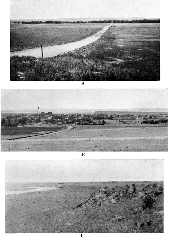
Plate II--A, Valley of south fork of Smoky Hill river south of Wallace. On the sky line is the rocky escarpment of the High Plains plateau composed of Ogallala. There is a veneer of Sanborn loess farther south. B, Sharon Springs looking north. Negative by Maddy, Sharon Springs. C, Valley of south fork of Smoky Hill river northwest of Sharon Springs. On the right is a typical combination of yucca and prickly-pear cacti, abundant on the valley slopes formed of loess.
The boundary line between the Pierre and Niobrara in the adjacent areas of Colorado and Nebraska appears to be about as sharp as in western Kansas. According to a recent geological report on the northeastern part of Colorado, "where observed, the two formations are conformable, and usually there is a variable transition zone, probably less than 10 feet in thickness, in which the yellow-cream or yellow-brown limy paper shales of the Niobrara are replaced by the dark-gray noncalcareous flaky shales of the Pierre." (Mather, Gilluly and Lusk, 1928, p. 83.)
This and the subsequent detailed description of the Pierre and Niobrara, by the same authors, leaves no doubt as to the sharpness of the contact, which here is also recognized by the appearance of calcareous sedimentary material in the Niobrara.
According to the observations of the Niobrara in southwestern Nebraska, "whenever the formation is overlain by Pierre shale, the chalky beds continue to the top of the formation," (Condra, 1907, p. 17) which shows that here, too, the boundary between the calcareous Niobrara and the "unctuous" and "loose-textured, carbonaceous clays" of the Pierre is sharp.
The relation between the Pierre and the Niobrara is described by Meek and Hayden along the Upper Missouri river in south-central South Dakota and northeastern Nebraska. According to the final description of the "general section of the Cretaceous rocks" by these two authors there is at the base of the Pierre a local "dark bed of very fine unctuous clay containing much carbonaceous matter, with veins and seams of gypsum, masses of sulphuret of iron and numerous small scales of fishes." This bed is "filling depressions in the bed below," which means in the Niobrara (Meek, 1876, p, xxiv). It seems that here, also, the contact between the dark and unctuous clayey shale of the Pierre and the "lead-gray calcareous marl" of Niobrara is fairly distinct. It is interesting, however, that an unconformity between the Pierre and Niobrara was recorded by Meek and Hayden for this locality--an observation not repeated as yet elsewhere. Neither was any kind of unconformity between these two formations observed during the latest exploration of the area where formerly Meek and Hayden studied these rocks (Condra, 1908, pp. 13-15. For further discussion of the problem see pages 56 and 58 of this report.). Condra noticed that there is in the Pierre a zone of "alternating beds of shaly chalk and clay, the former weathering reddish; these chalky beds are often mistaken for Niobrara chalk (Idem, p. 16). It would be interesting to determine whether these beds of shaly chalk in the Pierre contain calcareous matter or merely imitate the porous character of chalky rocks and are noncalcareous, as do the chalklike porous beds in the upper part of the Sharon Springs shale member of the Pierre in Wallace and Logan counties (see description of the rock in the chapter on the Pierre). Outside of this appearance of chalky, or possibly only pseudochalky, beds in the Pierre shale much above the contact with Niobrara, it appears that in northeastern Nebraska. the contact between the Pierre and the Niobrara is also manifested by the change from calcareous to noncalcareous sediments and is fairly sharp.
According to Meek and Hayden the thickness of the Niobrara at the type locality is 200 feet (Meek, 1876, p, xxv). Condra states that the total thickness of the Niobrara west of St. James, Neb., "at the margin of Pierre. . . is over 200 feet." [Condra, 1908, p. 13] Toward the northwest the thickness of the Niobrara, according to well logs, increases to 375 feet in the north part of Ziebach County, S. Dak., (Russell, 1925, pp. 5-6) and toward the southwest it increases also, reaching 300 to 400 feet. Along Republican river in southwestern Nebraska, according to Condra, the lower member of the formation, which is probably equivalent to the Fort Hays beds of Kansas, is 40 to 50 feet thick, and the upper member is about 300 feet thick (Condra, 1907, p. 17). The data from the well logs of northwestern Kansas and northeastern Colorado show a further increase in thickness of the formations toward the south and west.
The thickness of the Niobrara of western Kansas was formerly underestimated (Logan estimated it to be 350 feet (1897, p, 234), Williston considered it to be nearly 400 (1897, p. 237) and Darton placed it at about 350 feet (1905, p, 154)). The later figures, based on the study of the new deep wells of the area, are more accurate. Lupton, Lee and Van Burgh estimate the thickness of the Niobrara in Logan and Gove counties to be about 700 feet, (Lupton, Lee and Van Burgh, 1922, p. 71) whereas Russell states that in Logan County "the thickness of the Smoky Hill chalk [alone] is known from well logs to be 700 feet, but decreases eastward." Considering the Fort Hays limestone, which has a very persistent thickness in the area, to be 50 to 60 feet thick, the total thickness of the Niobrara is 750 to 760 feet for Logan County, according to Russell. In his columnar section of the Smoky Hill chalk, based on field estimates, Russell gives the thickness of the chalk as only 600 feet, probably because the lower part of the member was measured east of Logan County, where it is thinner (Russell, 1929, p. 696). According to his estimation "the third subdivision," the base of which he places about 300 feet above the base of the Smoky Hill chalk, is "175 feet thick in eastern Logan County and 135 feet thick in eastern Gove County," which is a decrease in the thickness of the subdivision of 40 feet in six townships, or a little more than 1 foot to a mile. According to the estimate by Landes and Moss, the "Smoky Hill chalk member is 700 to 800 feet thick in the western end of the state" of Kansas (Landes, 1930, p. 16).
Unfortunately the cuttings of the two deep wells that have been drilled for oil in Wallace County are not known to have been examined by a geologist, and now only the logs of these two wells made by the drillers .are available for examination. In the northern (Robidoux) well the undifferentiated "shale" which is recorded above the "white lime" of undoubtedly Fort Hays age, includes both Pierre and Niobrara, In the log of the other (Wulfekuhler) well a change from "green shale" above to "black shale" below is recorded at 325 feet, and a further change from black to "gray shale" is recorded at 375 feet, below which the "white lime," apparently the Fort Hays, was encountered from 965 to 1,025 feet. If the change from black to gray shale was at the Pierre-Niobrara contact, the thickness of the Niobrara in this well would only be 650 feet, which is 50 to 100 feet less than the estimate of the thickness of Niobrara based on the more reliable identifications of the Pierre-Niobrara boundary line in the close neighborhood of Wallace County.
An important well for the estimation of the thickness of the Niobrara is the one drilled 8 miles east of the Wallace-Logan county line, in SE SE sec. 20, T. 12 S., R. 36 W. In the log of this well a change from "black" to "gray shale" is recorded at 65 feet below the surface. This change is interpreted as the contact between the Pierre and the Niobrara, the latter certainly being here not far below the surface. The writer examined the outcrops of the Pierre shale at the well and in the surrounding area and compared the elevation of these outcrops and the well by altimeter. His conclusion is that the well was started about in the middle of the lowermost or Sharon Springs shale member of the Pierre, which is about 155 feet thick, and therefore the change from black to gray shale in the well must correspond closely to the Pierre-Niobrara contact, as was previously concluded. As the Fort Hays limestone, which was recorded in the log as "white chalky rock," was met from 705 to 755 feet below the surface, the thickness of the Niobrara in this well must be 690 feet.
At Horace, in Greeley county, which is the next county south of Wallace, "the deep boring found the top of the formation [Niobrara] a short distance below the surface and apparently about 650 feet thick, although a portion of the topmost beds has been removed by erosion." [Darton, 1905, p. 166] Farther southwest, in the Arkansas valley of Colorado, the thickness of the Niobrara is estimated to be about 700 feet (Gilbert, 1896, p. 666). The same estimate is given for the thickness of the Niobrara in Pueblo county, Colorado, by Darton (Op. cit., p. 107), who is inclined to give even a larger figure, about 740 feet, for the thickness of the Niobrara at Boone, Colo (Idem, p. 357).
The deep well at Cheyenne Wells, Cheyenne county, Colorado, according to Darton (Idem, p. 329), penetrated loess and a variety of apparently Ogallala sands down to 215 feet, when "black shale," undoubtedly Pierre, was encountered. The change from "black shale" to "white sandy shale with gas" was recorded at 534 feet, below which, at 1,260 feet, the "chalk rock with brackish water," having a thickness of 70 feet, was met. The latter rock is undoubtedly Fort Hays limestone, and if the change from black shale to white sandy shale with gas corresponds to the contact of the Pierre and the Niobrara, which is most probable, the total thickness of the Niobrara in this well is 796 feet.
In a well drilled north of Goodland, in Sherman County, which is the next county north of Wallace, the "lime shells" from 1,960 feet to 2,000 feet is probably Fort Hays, above which a "show of oil and gas" at 1,281 feet is recorded. If the latter depth corresponds to the top of the Niobrara, the thickness of Niobrara in this hole would be 719 feet. It is appropriate to notice that the gas horizon of Beecher Island, in Yuma county, Colorado, which is about 40 miles northwest from the Goodland well, is customarily considered to be at the top of the Niobrara. The estimate of the thickness of Niobrara at Beecher Island by the geologists of the U. S. Geological Survey (Mather, Gilluly and Lusk, 1928, p. 111), compared with the data of the log of the Midfield Oil Co.'s well No. 2 at Beecher Island, shows that they share this opinion.
The above references as to the thickness of the Niobrara east, south, west and north of Wallace County seem to indicate that the thickness of this formation in Wallace County can hardly be less than 700 feet and most probably ranges from 700 to 750 feet.
Wherever observable the contact between the Pierre and the Niobrara in Wallace and Logan counties appears to be conformable (For the discussion of other observations and opinions in regard to the contact between the two formations see pages 66 and 58 of the chapter on the Pierre formation). Perfect conformity between the two formations was assumed to exist when reducing the elevations of the various outcropping key beds in Wallace County to the top of the Niobrara, which was chosen as the main key bed for the structural map supplementing this report.
Lithologically the chalk of the Smoky Hill member of the Niobrara formation is "made up of coccoliths, but with a considerable quantity of both rhabdoliths and foraminifera" (Williston, 1898, p. 109). Besides these organic remains the sponge spicules and "certain round, yellowish bodies that were occasionally seen in the empty tests of foraminifera" (McClung, 1898, p. 427) have been found in the chalk. The organic constitution of the Smoky Hill rock thus shown and its porosity fully justify the name chalk, now generally applied to the whole member. The difference between the Kansas chalk and the white chalk of England and western Europe is chiefly difference in color and is due to the impurities in the former. The original color of the Smoky Hill chalk, which can be seen in the deep-well cuttings and occasionally in some natural exposures, is for the most part gray to light gray, which when weathered turns to bright orange, cream-yellow or rarely pink, all these of soft pastel shades. In the lower half of the formation a snow-white chalk is found occasionally. The gray color of the unweathered chalk is undoubtedly due to the fine particles of iron sulphide (pyrite or marcasite), which are more or less uniformly distributed through the rock and most probably represent the residue of the decayed organic matter. Though the color of the larger bodies of iron sulphides (which are also occasionally met in the chalk) is golden yellow to bronze yellow, the color of the powdered iron sulphide is gray. In the portions of the chalk that have been affected by weathering the larger bodies of iron sulphide are converted on the outside into the yellowish-brown rust of the common hydrous oxide of iron (limonite). The weathering of the fine particles of the same sulphide embedded in the rock produces the change of color of the rock from gray to various light shades of yellow, brown and red, depending on the particular oxide or hydrous oxide into which the iron of the sulphide is converted and on the admixture of otherwise colored particles.
Two analyses of Kansas chalk were made by G. E. Patrick, who refers them to the rocks collected from 300 to 320 miles west of Kansas City, "within 3 miles of the Kansas Pacific railroad." The place thus located by this author is somewhere in Trego county, Kansas, and therefore the rock came from the lower half of the Smoky Hill chalk. The first analysis is of "a fine specimen of snowy whiteness," and, as Patrick states, "No. 2 had a light yellowish tinge and was as poor a sample as I could select." [Patrick, 1875 (reprint in 1906), pp. 13-15]
| Analyses of Smoky Hill Chalk. (G. E. Patrick, Analyst.) |
||
|---|---|---|
| No. 1 | No. 2 | |
| Moisture | 0.34 | 0.58 |
| Insoluble in acids (silica, lime and alumina) | 69 | 11.40 |
| Alumina (little oxide of iron) | .43 | .97 |
| Ferrous carbonate | .14 | 2.83 |
| Calcium carbonate | 98.47 | 84.19 |
| Total | 100.07 | 99.97 |
These two analyses show the variation of the amount of impurities in the Niobrara chalk, but also show that the calcareous matter is probably always predominant.
Two analyses of the Niobrara chalk from northeastern Nebraska have been published and are as follows (Condra, 1908, p. 16):
| Analyses of Niobrara Chalk from Northeastern Nebraska (Howison Crouch, Analyst.) |
||
|---|---|---|
| Unweathered specimen | Weathered specimen | |
| Moisture | 0.70 | 1.11 |
| SiO2 | 4.52 | 6.02 |
| Organic matter | 3.14 | 1.03 |
| SO3 | 2.14 | .85 |
| CO2 | 37.80 | 37.11 |
| CaO | 49.66 | 47.98 |
| (subtotal) | (87.46) | (85.09) |
| Fe2O3 and Al2O3 | 1.87 | 5.92 |
| MgO | Trace | Trace |
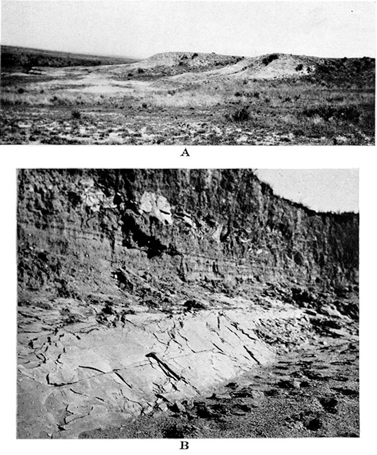
Plate III--A, Contact of Pierre and Niobrara in the NE, sec. 1, T. 14 S., R. 38 W. Shows more pronounced bench of Niobrara chalk (at the left) compared with the overlying Pierre shale. B, Fine cleavage in Niobrara chalk with inclination about 45 degrees to the bedding planes. From the SE SW sec. 31, T. 13 S., R. 38 W. Above is reworked loess full of Niobrara debris.
Probably the analysis of Patrick's rock No. 2 and the analyses of the Nebraska chalk are much closer to the average chemical constitution of the Smoky Hill chalk than Patrick's snow-white chalk, which is a comparatively rare variety in the formation. The amount of impurities in the more ordinary varieties of the rock, which are chiefly argillaceous matter and oxides of iron, are apparently not so great as to make the name chalk inapplicable.
Bass, who made a detailed study of the exposed parts of the basal 100 feet of Niobrara chalk in Ellis county, describes this portion of the formation as consisting of "marl beds alternating with chalk and thin beds of clay" (Bass, 1926, p. 19). The thin beds of clay are referred by Bass to the bentonitic clays, and in the detailed descriptions of the sections marls are called chalky shale, chalky clay shale and clay shale. According to observations by Bass there are two "units" in the lower Niobrara, consisting of the interbedded chalk, chalky shale, shale and bentonitic clay, which are very persistent in their lithology and are "readily traceable beds in the Smoky Hill member exposed in Ellis county" (Idem, p. 21). He also observed that "a series of hard and soft chalky shales and chalk with a few interlaminated bands of bentonitic clay," which belong to the upper part of the Niobrara, appear to be traceable in the exposures of Logan County (Idem, p. 20). During the Etnyre Syndicate survey in Logan County in 1927 a series of analyses of Niobrara rocks selected by O. E. Stoner was made in order to determine the constancy of the calcareous matter within some readily traceable beds. These analyses proved that the amount of calcium carbonate in these beds is fairly constant and that the determination of it can be used for checking field correlations of key beds in the formations.
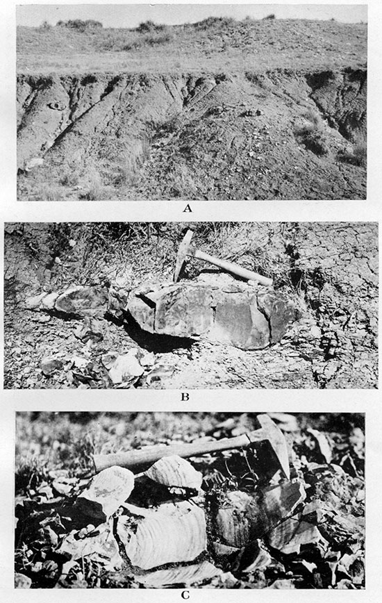
The pure or nearly pure chalk of the Niobrara is a porous rock, whereas the chalky shale with which it is interbedded is apparently less porous. The latter rock seems to predominate in the formation. The degree of porosity of these rocks, as far as known to the writer, has never been a subject of precise study. However, the deep wells that have penetrated the formation in western Kansas and eastern Colorado prove that there is no artesian water in the formation, though it is underlain by impervious shale and though a large supply of water, which rose high into the Niobrara (about 250 feet above the base of the Fort Hays), was met in Dakota sands in the Wulfekuhler well and in other wells. On the other hand, gas is nearly always encountered within the Niobrara, usually near the top, and brackish water in the Fort Hays was met in the well at Cheyenne Wells. These occurrences indicate that the formation is not entirely impervious, but contains some channels along 'which gas and water can pass. These channels may be provided by the more pervious portions of the formation or perhaps by a series of fissures, a network of which probably penetrates the rocks. All field observers agree that the Niobrara is much broken into tilted blocks. Furthermore, as the writer has observed, in some places in the formation a closely spaced cleavage about 45° to the bedding planes is developed (see Plate II B), which is probably a consequence of twisting. The atmospheric water performs its destructive work along these various fissures, as can be seen clearly in the eroded cliffs of Niobrara in Gove and Trego counties (Observations by K. K. Landes, oral communication to the writer). On the other hand, the writer observed the filling of some fault fissures with calcite in the SW sec. 36, T. 13 S., R. 38 W., in Wallace County (Plate IV) (A similar observation of calcite deposited along fractures of fault planes in the chalk of western Kansas was made by R. C. Moore, 1926a, p. 3). The calcite is dense and crystalline and is covered with slickensides. Apparently it crystallized from water solutions when the faulting process was not yet completed and when these uppermost Niobrara beds were buried under the overlying Pierre shale, which is now eroded away.
Plate IV--A, Fault in Niobrara chalk with crystalline calcite filling the fault fissure. From the NW, sec. 36, T. 13 S., R. 38 W. B, Slickensides in crystalline calcite which fills the fault fissure. Photographed on the other side of the little knob shown in A.

The presence of many fissures in the Niobrara, along at least some of which underground water apparently circulated, appears to explain satisfactorily the origin of caves within the formation, over which the local subsidences of the area occur. (See chapter on local subsidences.)
The scattered outcrops of Niobrara in Wallace County belong to the uppermost beds of the formation. The outcropping rocks appear to be nearly uniform in constitution and physical properties, containing no particularly prominent ledges that could be easily recognized in the field by their lithology or fossil content. As the outcropping portion of the Niobrara in Wallace County afforded no opportunity to study the detailed stratigraphy of this formation, the writer limits himself to a brief review and summary of the present data on the Niobrara stratigraphy in Kansas as given by other authors.
Generally the Niobrara of Kansas is divided into the Smoky Hill chalk above and the Fort Hays limestone below, the two members being comparatively easily recognized both in surficial exposures and wells. The Fort Hays is only 50 to 60 feet thick. The beds of this member are described by Rubey and Bass (Rubey and Bass, 1925, pp. 28-30) and in still more detail by Bass (Bass, 1926, pp. 24-25 and pp. 62-63). The latter author gave also the first detailed description of the basal 70 feet of the Smoky Hill chalk, within which he recognized two well-exposed and prominent groups of beds, which he designated group A, from 55 to 70 feet, and group B, from 10 to 20 feet, above the base of the Smoky Hill member (Idem, pp. 19-23). Russell attempted to divide the whole thickness of the Smoky Hill chalk of Logan, Gove and Trego counties into four subdivisions, and specified ten topographically prominent or otherwise noticeable groups of beds in the chalk, with intervals of beds less prominent or not exposed at all. The scheme of Russell, which is based on lithologic observations in the field alone, is presented in modified and generalized form in the table on pages 42 and 43 (Russell, 1929). The fossil content of the subdivisions or groups of beds of the Smoky Hill chalk is left out of consideration in Russell's scheme.
In another table the earlier subdivision of the Niobrara formation as given by Williston, chiefly on paleontologic but also on lithologic grounds, is presented (Williston, 1892; also Williston, 1897 and 1898). Some additional names of invertebrates are added to this scheme after W. N. Logan (Logan, 1898).
Thanks to the description by Williston of some of the most prominent and picturesque exposures of "yellow chalk" in Gove County, and with the help of the boundary line outlined by him between the Hesperornis and Rudistes beds in northwestern Kansas, it is possible to conclude that the Hesperornis beds or yellow chalk of Williston corresponds to subdivisions III and IV of Russell, and that the Rudistes beds correspond to subdivisions I and II of Russell.
| Paleontologic Subdivision of the Niobrara Formation. | ||
|---|---|---|
| (Modified after S. W. Williston, 1892, 1897 and 1898, with addition of invertebrates after W. N. Logan, 1898.) |
||
| Hesperornis beds or Yellow chalk: | ||
| Yellow often buff or reddish chalk; smooth and soft to touch. | ||
| Bivalves: | ||
| Ostrea congesta Conrad--not very abundant. | ||
| O. larva Lamarck--rare. | ||
| Inoceramus pennatus Logan. | ||
| I. subtriangulatus Logan. | ||
| I. platinus Logan. | ||
| Arthropods: Squama lata Logan--at base of beds. | ||
| Mosasaurs: | ||
| Clidaster and Mosasaurus, which are absent in the Rudistes beds. | ||
| Platecorpus and Tylosaurus, which are absent in Pierre. | ||
| Pterodactyls (Ornithostoma) more numerous than in the Rudistes beds. | ||
| Toothed birds: Hesperomis, Ichthyornis, etc.--restricted to these beds. | ||
| Rudistes beds: | ||
| White or gray chalk, never deeply yellow. | ||
| Shales of lighter blue. | ||
| Ammonites and Belemnites rare. | ||
| Bivalves: | ||
| Ostrea congesta Conrad--very abundant. | ||
| O. larva Lamarck--rare. | ||
| Inoceramus (Haploscapha) grandis (Conrad). | ||
| I. (Haploscapha) niobraraensis (Logan). | ||
| I. (Haploscapha) eccentrica (Conrad). | ||
| I. concentricus Logan. | ||
| I. truncatus Logan. | ||
| I. platinus Logan. | ||
| Parapholas sphenoidens White. | ||
| Rudistae: Gigantic Radiolites maximus Logan. | ||
| Echinoderma: Uintacrinus socialis Grinnell--in top of beds. | ||
| Arthropoda: | ||
| Squama spissa Logan--at base of beds. | ||
| Stramentum (Pollicipes) haworthi (Williston) Logan. | ||
| S. tabulatum Logan. | ||
| Mosasaurs: Platecarpus and Tylosaurus. | ||
| Fort Hays limestone: | ||
| Bivalves: | ||
| Inoceramus deformis Meek--in top of limestone. | ||
| I. browni Cragin. | ||
| I. flaccidus White. | ||
| I. simpsoni Meek. | ||
| Lithological Subdivision of the Niobrara Formation. | ||
|---|---|---|
| (Modified after W. L. Russell, 1929.) | Feet. | |
| IV. | Brownish-yellow weathered calcareous shale. Many comparatively thick streaks of bentonite | 125 |
| III. | Calcareous shale weathered in places to massive, yellowish-white, cliff-making chalk. (Pyramid rock, Castle rock, etc., of Gove County, Kansas) | 175 |
| II. | Soft, thin-bedded, calcareous shale; no conspicuous hard or massive ledges. Many thin bentonite streaks. Round pyrite concretions especially abundant | 150 |
| 1. | Upper part: Two thin, hard, white ledges with dark shale between (12 feet). Lower part: Many thin but persistent hard ledges with very thin bentonite streaks between (133 feet) | 145 |
| Fort Hays limestone--considerably harder than Smoky Hill chalk | 50-60 | |
Pierre Formation
In his classical description of the Cretaceous invertebrates of the "upper Missouri country," which is still the main source of our knowledge of the invertebrate paleontology of the Great Plains, Meek says (Meek, 1876, p. xxxiii):
"Fort Pierre group . . . is perhaps the most important member of the series, not only on account of its thickness and the extent of its geographical range, but also from the great number and the beautiful state of preservation of its organic remains."
The Pierre formation crops out over a considerable area of the central Great Plains from eastern North and South Dakota, through northern and southwestern Nebraska into Colorado, cutting the northwestern corner of Kansas, where the Pierre is the uppermost member of the local Cretaceous. The formation also covers a considerable area in Wyoming, Montana, easternmost Utah and Idaho, and extends far into Canada, where corresponding beds have been subdivided into Judith river, Claggett and Eagle Creek shales and sands. The equivalents of the Pierre extend, also, through Colorado into northeastern Arizona, New Mexico and Mexico. The Pierre shale of this enormous area represents sedimentation in a great inland sea of Upper Cretaceous time. This sea was connected by way of Mexico and Texas with another great sea, which covered parts of the Gulf coast, lower Mississippi valley, and southern Atlantic coast states.
The exposures of northwestern Kansas lie about in the middle of the eastern border of the Pierre outcrops. Should we remove in our imagination the youngest arenaceous formations of Wallace County, the alluvium, loess, gravel, Tertiary "mortar beds" and clays, we would find the whole county covered with the Pierre formation, except a very narrow zone on the south side of Smoky Hill river, southwest of Wallace, where the underlying chalk of the, Niobrara formation is exposed. The Pierre formation is known to the citizens of Wallace County as "shale," the impervious bottom rock that supports the water in the majority of the local water wells.
The formation is about as fossiliferous in Wallace County as it is in the type locality along the Missouri river below Fort Pierre, and the Pierre of western Kansas is as thick as or even thicker than there. The well-preserved fossils, which are chiefly the remains of invertebrate organisms of the Pierre sea, are important not only as relics that teach us of the life on our planet in the remote past, but they are also tokens by which the several beds can be recognized. Unless the various outcropping beds of the 600 feet of the Pierre are grouped into members, no surface structure map of the area can be prepared, and consequently no particular place can be recommended in preference to others for an oil or gas test well. A structural map based solely on the observations of local dips of the strata is not reliable, because the dips in the Pierre shale (as well as in the underlying Niobrara) are very variable within a short distance! and often the locally observed dips are contradictory to the actual dip of the formation as established by the correlation of the outcrops. This is due to the small-scale tilting and occasional faulting of the formation or the slumping of the surficial portions of the shale. The unreliability of structural mapping in western Kansas based on observed dips alone has already been pointed out by a few authors (Twenhofel, 1925, pp. 1064-1065; Russell, 1929, pp. 603- 604). Therefore the subdivision of the Pierre and correlation of its outcrops must be regarded as essential preparation for the structural mapping of the county. Though in a few exceptional places the correlation of beds can be based on the lithology alone, this means of correlation usually cannot be trusted unless checked by some other means, because various beds and zones belonging to different horizons have a similar lithology and can be easily confused. The writer has observed attempts to correlate some portions of the Pierre of Wallace County with the Pierre outcropping at Beecher Island, Yuma county, Colorado, on the sole basis of the existence of streaks of bentonite associated with limestone concretions in both areas. But observations by various geologists have revealed that streaks of bentonite are common throughout the whole Pierre as well as in the Niobrara and Benton formations of the Great Plains and elsewhere (See descriptions of Pierre and other formations by Mather, Gilluly and Lusk, 1928; by Pinkley and Roth, 1928; by W. L. Russell, 1929; by Baker, 1928; and others.).
The ammonites of the shale that is exposed at Beecher Island belong chiefly to the Discoscaphites group and include the species D. conradi, D. abyssinus and others, which elsewhere are exclusively Fox Hills and uppermost Pierre forms. Contrary to this, in the Pierre shale of Wallace County these species are absent, while Acantoscaphites nodosus of middle Pierre and allied forms are very common. A nearly complete change of all other fauna is also noticed in the shale of Beecher Island from that of Wallace County, the same groups and genera of marine animals being represented by distinctly different species.
This paleontologic evidence is completely supported by the data of the deep wells in Wallace County and at Beecher Island. The particular shale of Wallace County (the Weskan shale), in which the bentonite streaks allegedly identical with those of Beecher Island were observed, is only about 300 feet above the top of the Niobrara, and the Pierre shale within Wallace County is nowhere more than 600 feet thick, whereas below the shale with bentonitic streaks outcropping at Beecher Island there is 1,400 feet of Pierre shale above the Niobrara. Allowing a certain amount of decrease in the total original pre-erosional thickness of the Pierre of Wallace County compared with the Pierre at Beecher Island, as is estimated below, we still conclude that the equivalents of the lower horizons of the Pierre exposed at Wallace cannot possibly outcrop at Beecher Island, being there hidden below about 600 to 700 feet of the upper Pierre shale.
The importance of the study of the lithology of the Pierre certainly cannot be questioned, and actually the appearance and constitution of the rocks is always the first thing that is observed and studied by a geologist in the field. But the lithology of the Pierre shale is so uniform that only a very careful and detailed study of the different beds, bentonite streaks, and concretions scattered or arranged in zones will make possible any correlation of the outcrops, and such a correlation should always be checked by some other means. This can be done by study of the fossil content of the beds and zones and sometimes by observing the succession of the beds.
Water wells drilled into the Pierre will strike no water supplies in this formation, for there are no sands or pervious limestones known in the Pierre of western Kansas and easternmost Colorado. Neither do any water-bearing horizons occur in the underlying Smoky Hill chalk. Several thick sandstone members are known in the Pierre of the Rocky Mountain region of east-central Colorado, where the formation reaches an enormous thickness of 8,000 feet or more, but all these sandstone members are local and pinch out before reaching the boundary line of Kansas. Beds of "impure chalk" and "chalky clay" have been noted in the lower Pierre along the Missouri river in northeastern Nebraska (Condra, 1908, pp. 15-17), and in the upper Pierre of Ziebach County, Nebraska, calcareous shale was observed (Russell, 1925, p. 4). According to Fenneman the Pierre of the Boulder district, Colorado, though in general noncalcareous, has local limy beds (Fenneman, 1905, p. 31). "At places these form continuous strata, as, for example, 4 miles north of Boulder, one-half mile east of the contact with the Niobrara. Here for a thickness of nearly 40 feet strong limestone beds are so closely grouped as to give the outcrop the appearance of the basal Niobrara." These limestone beds appear to belong to the lower portion of the Pierre, below the Hygiene sandstone, according to the maps of the area by Fenneman (Idem, map on p. 44) and by Henderson (Henderson, 1920, map in pocket). Fenneman adds: "At other places the limestone beds are smaller and more isolated," and "less prominent calcareous masses may be found at any horizon either in beds or more or less perfect concretions." Outside of this statement by Fenneman, which is repeated in some later papers, no other records of limestone beds in the Pierre of eastern Colorado are known to the writer. No calcareous beds were observed in the Pierre shale of Wallace County and the only calcium carbonate present was in concretions or very rarely in thin and discontinuous streaks.
Beds and lenses of a very peculiar light porous shale were observed by the writer in several outcrops of the Pierre about 100 to 150 feet above the top of the Niobrara in Wallace County. This shale is not "soapy" like the usual Pierre shale, but has a "chalky" appearance and somewhat resembles the Mowry shale of the Benton, except not being hard and siliceous. But this shale would not effervesce, either with cold or hot hydrochloric acid, and therefore does not contain any calcium carbonate or dolomite.
A few very thin and nonpersistent streaks and lenses of fine clayey sand were observed, but they are negligible in size and number. By decantation of the fine material in Pierre shale cuttings from a deep well at Beecher Island the writer invariably obtained a small quantity of fine sand together with some foraminifera and other organic remains. This sand is composed almost entirely of quartz grains. Its presence in such a small amount does not make the shale sandy in appearance and does not add to the porosity of the rock to an appreciable degree. Except the peculiar porous shale occasionally found in the lowermost Pierre, which is light gray or nearly white when weathered, the Pierre shale of Wallace County is dark gray to black and is usually unctuous. It weathers to lighter shades and when much weathered may be greenish or brownish gray. Much of the Pierre shale is distinctly laminated, and in places it is minutely banded.
Pyrite or marcasite, chiefly in the form of minute casts of Foraminifera or in the form of a crust associated with other organic remains, is fairly uniformly scattered through the whole formation and can be found in every piece of fresh shale. These minerals, however, rapidly decompose near the surface and are replaced by iron hydroxide and by flakes or larger crystals of gypsum. Owing to this action the outcropping shale is usually full of rusty spots and almost always has thin crystals of selenite sparkling here and there but chiefly along the cracks. Some zones of the shale are especially impregnated with large crystals of gypsum, which crystallized along the bedding planes and the larger cracks, but nowhere do these crystals form anything like a bed, and neither are. they sufficiently concentrated in the shale to make a commercially important deposit. Thin streaks and moderately large concretions of iron hydroxide in the form of limonite are abundant in places, but again the quantity is insufficient to make a commercial deposit of iron ore. In a few outcrops a little hard black manganite was found in small kidney-shaped concretionary crusts, which were associated with organic remains of invertebrates.
The Pierre shale of eastern Colorado, which does not differ much in constitution from the Pierre shale of western Kansas, was analyzed and physically tested by G. M. Butler, from whose report the following selected analyses are quoted (Butler, 1915, p. 342). They give a good illustration of the variable chemical and mineralogical content of the Pierre shale.
| Ultimate analysis (in percentages). | ||
|---|---|---|
| (1) | (2) | |
| SiO2 | 54.30 | 66.31 |
| Al2O3 | 15.02 | 13.69 |
| Fe2O3 | 9.48 | 4.41 |
| CaO | 4.08 | 2.28 |
| MgO | .86 | 1.58 |
| K2O | 2.64 | 2.22 |
| Na2O | .43 | 1.19 |
| Loss on ignition | 9.11 | 6.40 |
| Moisture | 1.68 | 1.68 |
| CO2 | ||
| SO3 | Trace | |
| 99.60 | 99.76 | |
| Rational analysis (in percentages). | ||
|---|---|---|
| (1) | (2) | |
| Kaolin | 28.83 | 23.55 |
| Quartz | 28.20 | 39.86 |
| Feldspar | 19.22 | 23.22 |
| Limonite | 11.08 | 5.16 |
| Calcite | 4.08 | |
| Gypsum | 12.58 | |
| 99.91 | 95.87 | |
| In the table on page 342 of Butler's report 18.20 of quartz is shown, which is apparently an error of the printer. Compare the total and the content of SiO2 of the ultimate analysis. | ||
As mentioned already, the Pierre shale of Wallace County occasionally contains thin streaks of greenish or grayish-white or rarely brownish soapy rock (Pl. VII A), which is usually classed as bentonite of the Benton formation, an altered volcanic ash (Ross and Shannon, 1926). This rock of the Pierre, when immersed in water, swells considerably and disintegrates at once into a very fine mud. Mineralogically the rock consists chiefly of kaolinite or a related mineral, in which often flakes of biotite are present.
Concretions of varied size and constitution are very common in the Pierre. For the most part they are composed of calcium carbonate, of siderite and of limonite, and often of a mixture of two or three of these minerals. A more detailed description of these concretions is presented in the discussion of the members of the Pierre.
Often the concretions are more numerous along some particular bedding planes, and in places the limonite forms nearly continuous though thin concretionary beds. Both the limestone and the limonite concretions usually gather in some particular zones, being rare or absent in intermediate zones of the shale. These concretionary zones outcrop as prominent escarpments or form benches in the shales (Pl. IV, Pl. X A), thus furnishing local key beds that are usable in structural mapping. The best invertebrate fossils were collected in or around the concretions (Pls. VIII C, IX B, XII D), and helped to identify and correlate the concretionary zones. A detailed account of these zones and their fossils is given in the descriptions of the local members of the Pierre.
Plate X--A, Concretions of gray to white compact limestone of bed No. 8, the top bed of the middle concretionary zone of Upper Weskan shale member. From the center of the NW, sec. 18, T. 13 S., R. 41 W. B, Detail of a concretion like those shown in A. C, Cast of a large Inoceramus shell in a concretion of the bed shown in A. From the SE NW of the same section.
The maximum thickness of the Pierre in Wallace County, as measured on the outcrops and partly computed from the well logs, is about 600 feet, which, as will be shown below, is only the remaining lower half of the formation, the upper half being eroded away.
The regional dip of the Cretaceous formations in Wallace County is almost north, and its average is about 20 feet to a mile. However, owing to the general slope of the surface to the east, the boundary lines between the members of the local Cretaceous crop out approximately in the west-southwest east-northeast direction (see geologic map of the county). Southeast of Wallace, along the south side of Smoky Hill river, the base of the Pierre is seen resting upon the uppermost beds of the Smoky Hill chalk, and about two miles northwest of the town, at the Wulfekuhler deep test well, there is about 285 feet of Pierre shale above the top of the chalk, according to the interpretation and estimate of the writer. Seven miles farther north, at the Robidoux test well, the Pierre shale reaches the thickness of 375 feet, and about 28 miles from there in a northwesterly direction and north of Goodland, about 600 feet of shale overlies the chalk (all these figures according to the interpretation of the logs by the writer). In the northwest corner of Wallace County there is also about 600 feet of shale, which was computed on the outcrops.
The Andrews No. 1 well of the Phillips Petroleum Co., which was drilled in sec. 3, T. 23 S., R. 42 W., of Yuma county, Colorado, about 36 miles northwest of the above-mentioned Goodland well, passed through 1,430 feet of Pierre shale before it reached the top of the Niobrara (data on this well kindly furnished by the geologists of the company). The shale exposed around this well has nearly the same lithology and fossil content as the shale exposed about ten miles west, near Beecher Island, in Yuma county, Colorado, where nearly the same thickness of shale above the Niobrara was recorded. The fossil content of the outcropping shale of this area indicates the topmost beds of the Pierre or even a transitional zone between Pierre and Fox Hills. The tendency of these outcropping beds to approach the lithology of Fox Hills sandstones is indicated by a somewhat more solid and less "soapy" appearance of the shale, as if a larger quantity of fine sandy material was present. Furthermore, the increase of near-shore material in the formation is manifested by the appearance of the imprints of leaves of Salix, Ficus, Celastrus and other trees, which were collected from the shale near the Andrews well. (For a more complete account of this flora see pp. 130 and 131 of the report.) It appears, therefore, that 1,400 feet represents about the complete thickness of the Pierre formation in northeastern Yuma county of Colorado, and in northwestern Cheyenne county of Kansas, which is in the northwest corner of the state.
The Pierre shale of southwestern Nebraska was not estimated exactly, but is more than 1,000 feet along the western part of Republican river, according to Condra (Condra, 1907, p. 19). According to the writer's interpretation of the log of John Kelly No. 1 well, of the Prairie Oil and Gas Co., in sec. 33, T. 19 N., R. 55 W., in Banner county, western Nebraska, the thickness of the Pierre is here about 2,600 feet. The "dark gray lime" between 3,463 feet and 3,720 feet (257 feet thick) at the base of the great thickness of mostly "dark" shale is considered by the writer to belong to Niobrara, the thickness of which formation measured on the outcrops west of the well, in the Sherman quadrangle in Wyoming, is from 325 to 400 feet (Darton and others. 1910, p. 18), and north of the well, in the southern Black Hills region, it is 175 to 225 feet (Darton and Paige, 1925, p. 35). According to the elevation of the well (4,500 feet taken from the U. S. Geological Survey topographic map) and the geological map of the region (Darton, 1903) the well started in about the middle of the Brule clay (Oligocene). "Hard yellow pan" down to 400 feet, the intercalated "yellow mud," shale and sandy shale below to 815 feet and the "water sand" to 825 feet probably represent the sandy Chadron formation of the Oligocene and possibly the sandy Fox Hills formation of the Upper Cretaceous, which are known in distant exposures, west and north of the well. If this correlation is correct, the intermediate portion of shale having a few streaks of "sandy shale" between 825 feet and 3,463 feet of the well must correspond to the Pierre formation.
Darton gives approximate estimation of the exposed portion of the Pierre in the Black Hills region of South Dakota as about 1,200 feet, not including the uppermost bed (Darton and Paige, 1925, p. 14), and according to a recent estimate by Rubey the total Pierre of the southern Black Hills is 2,250 feet thick (Mather, Gilluly and Lusk, 1928, p. 111). According to the study of the lithology and fossil content of the cores of a recent well in Ziebach County, South Dakota, the thickness of the Pierre in that area is between 1,165 and 1,446 feet (Russell and Stanton, 1925, pp. 4-5 and p. 8). Todd gives an approximate estimate of the thickness of the Pierre in the region of the upper Missouri river, between Fort Pierre and Cheyenne river, as about 1,000 feet (Todd, 1908, p. 26).
West of the northwest corner of Kansas the thickness of the Pierre increases rapidly. It is estimated to be 2,210 to 2,250 feet in the Acron-Padroni area of northeastern Colorado, which is about 60 miles from the northwest corner of Kansas, and it increases to 5,000 feet at Boulder, Colo (Fenneman, 1905, p. 31). According to the measure of the outcrops of the Pierre by J. D. Sears and J. Gilluly (Mather, Gilluly and Lusk, 1928, pp. 90-92) "a minimum thickness of 8,000 feet may be attributed to the Pierre shale" at Fossil creek, south of Fort Collins, but it is around 7,000 feet at Wellington Dome (Idem. p. 114). The thickness of the formation decreases toward the north, being only about 5,000 feet at Horse creek, in Sherman quadrangle in Wyoming (Darton and others, 1910, p. 18). In the southern half of this quadrangle "on North Fork of Crow creek, where the entire thickness is exposed, and the beds are vertical, they measure 4,000 feet across, but are considerably crushed and much obscured by talus" (Idem, p. 10). In northeastern Wyoming the Pierre has much less thickness, and various authors place it from 1,250 feet (Darton, 1907, p. 5; Collier, 1922, p. 86) to 2,500 feet (Hancock, 1920, p. 21). The thickness of the Pierre decreases to about 2,500 or 2,600 feet at Pueblo (Gilbert, 1897, p. 3: "A thickness of 2,200 feet appears in the district, but the top is not seen." In his paper on underground water of Arkansas valley (Gilbert, 1896, p. 557) this author shows the total thickness of the Pierre of the region to be about 2,500 to 2 600 feet (Fig. 46 on p. 571)), and in the Walsenburg quadrangle the thickness is 1,900 feet, in the Huerfano valley, 1,750 feet south of Cuchara, and about 1,500 feet at the south boundary of the quadrangle (Hills, 1900, p. 2). The same thickness of the Pierre is given by Hills (Hills, 1901, p. 1) for the northeastern part of Spanish Peaks quadrangle, and farther southeast the Pierre decreases to 1,250 to 1,300 feet in the southern half of Elmore quadrangle (Hills, 1898, p. 2).
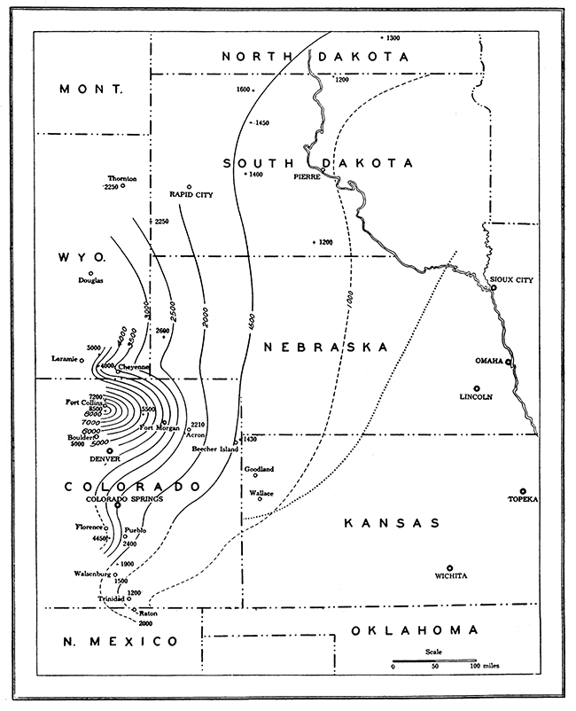
Figure 2--Map to show the original thickness of the Pierre formation in Midwestern states. Explanation: Contours in solid and in dashes indicate equal thicknesses of the formation; contour intervals, 500 feet; dotted line indicates eastern boundary of the present exposures of the Pierre.
South of Raton Mesa elevated plateau, however, the thickness of the Pierre increases again and is, according to Darton, "considerably more than 2,000 feet" (Darton, 1928, p. 43). In the Florence oil field the thickness of the Pierre increases to 4,450 feet (Eldridge, 1892, p. 450).
These figures for the thickness of the Pierre in the central Great Plains are plotted on the accompanying map, figure 2, in which contours connect the points of equal thickness. The map is generalized, of course, and does not give a very accurate representation of the original thickness of the Pierre, especially for the areas far away from the few points at which the thickness of the formation was established. It is hoped that the map will be gradually improved with the accumulation of new or more reliable data. Even in its present form a general idea is given of the variability of the original, pre-erosional thickness of the Pierre within the mapped area and a hint as to how far east the Pierre sediments must have been originally extended. The map has a particular and important value for stratigraphic study in Wallace and other counties of northwestern Kansas, because it helps to recognize the true stratigraphic position, or the position in relation to the complete pre-erosional section of the Pierre, of those exposed beds of this formation whose distance to the base of the Pierre can be established with the help of the deep wells. According to this map the original thickness of the Pierre in Wallace County must have been from about 1,000 to 1,300 feet. The actual measured thickness of the formation in this county, as was noted above, is only about 600 feet, which apparently represents only the lower half of the formation, the other half being eroded away. Comparison of the fossil content of the outcropping Pierre shale of the county with the paleontologic data from the Pierre in other regions confirms this conclusion, as will be shown below.
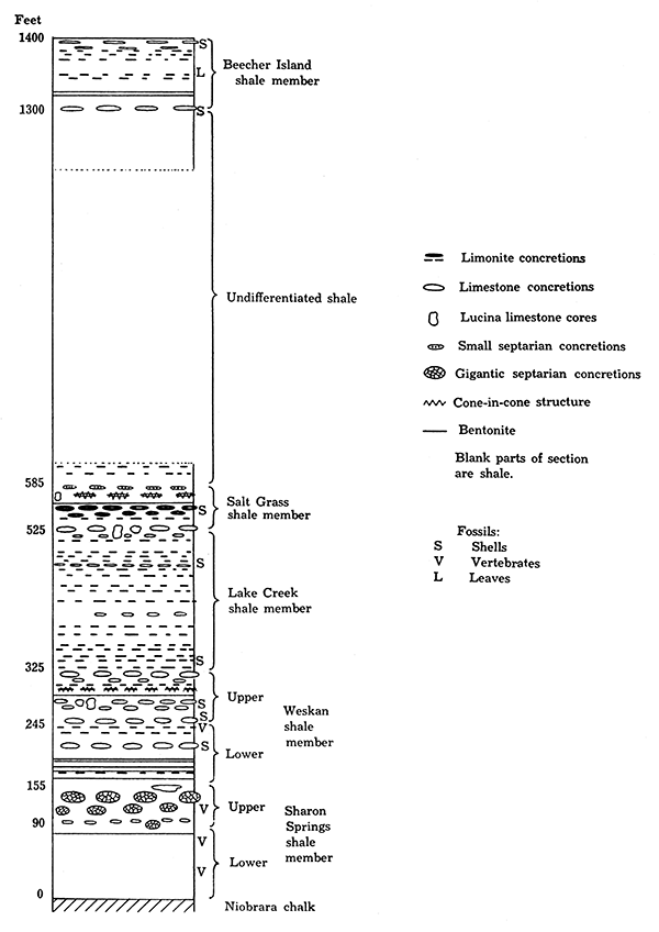
During the survey of Wallace County the local 600 feet of Pierre was subdivided into zones and members, on the ground of lithologic differences, together with some definite changes in fossil content. Owing to the little resistance to weathering of the soft shale, the Pierre formation in Wallace County is not widely exposed, and the same is true for nearly all other areas of the distribution of the Pierre in the Great Plains. For this reason and on account of the nearly featureless character of the shale throughout the thickness of the formation, few attempts to subdivide it have been made before. The method of field work employed by the writer has. been briefly described. The concretionary zones, which form escarpments in the outcrops of the Pierre, were used' as local key beds, but as these concretionary beds cannot be followed from one exposure to another, being covered in most places with a thick mantle of loess, detailed study of the sections of the Pierre in almost every observed outcrop was mil-de. Owing to some lateral changes in the concretionary zones, but still more to the repetition of the lithology of some stratigraphically different beds of the Pierre, the correlation of the sections of the separated outcrops was always checked by the fossil invertebrates which, fortunately, could be collected in sufficient number from nearly every outcrop of the formation. Only the outcrops of the lowermost 155 feet of the Pierre, which are almost barren of the invertebrates, were correlated on the lithology aided by the great abundance of small fish remains. The lithologic features of this member of the Pierre are so different from those of the rest of the formation that there was no danger of confusing it with the overlying members, even without checking it by the contained fossils. This lowermost member of the Pierre, which is named here the Sharon Springs member, has been described by various authors at localities north of Kansas and is remarkably persistent both in lithology and thickness.
The subdivisions of the 600 feet of the lower Pierre shale exposed in Wallace County are as follows, from top to bottom:
| Salt Grass member | 60 feet | Upper. |
| Middle. | ||
| Lower. | ||
| Lake Creek member | 200 feet | Upper. |
| Lower. | ||
| Weskan member | 170 feet | Upper, 80 feet. |
| Lower, 90 feet. | ||
| Sharon Springs member | 155 feet | Upper, 65 feet. |
| Lower, 90 feet. | ||
| Total 585 feet. |
As far as one can judge from the outcropping contacts of the Pierre and Niobrara southeast of Wallace, the Pierre is quite conformable upon the Niobrara. The study of the logs of wells north and northwest from here and of the outcropping beds of the Pierre at these wells shows that there is no appreciable regional nonconformity between the Pierre and Niobrara in the south-north direction, which is the direction of the regional dip. In the adjacent area on the west, in northeastern Colorado, Mather, Gilluly and Lusk observed that "Although generally obscured, the contact of the Pierre with the underlying Niobrara is conformable" (Mather, Gilluly and Lusk, 1928, p. 86). According to Condra, "the Pierre shale rests conformably on the Niobrara" in southwestern Nebraska.
Russell, who studied the Niobrara of Trego, Gove and Logan counties of western Kansas, states that "toward the northwest the Smoky Hill chalk is overlain unconformably by the Pierre shale" (Russell, 1929, p. 599). However, neither the data upon which this conclusion is based nor the character of the unconformity are mentioned by this author. Contrary to his conclusion is the following observation by Stoner for southern Logan County, which is based on the detailed survey and structural mapping of this area in 1927.
Figure 3--Generalized section of the Pierre formation in northwestern Kansas.
"It was found by careful measurements throughout an area of 2,000 square miles . . . that the intervals between the several beds of bentonite [in the uppermost 200 feet of the Niobrara] and between them and the Pierre-Niobrara contact [Italics by the writer] are extremely uniform . . . and that this relation did not differ more than 1 foot per mile in any direction." (Conclusions by O. E. Stoner as cited by Pinkley and Roth, 1925, p. 1021) Outside of the statement by Russell there is another allusion to an unconformity between the Pierre and Niobrara, and this is by Meek and Hayden for the exposures in northeastern Nebraska (A remark as to a "possible unconformity at or near the base" of the lowermost Pierre in northeastern Wyoming and southeastern Montana was made recently by Rubey (1930, p. 4), the particulars on this interesting possibility being probably reserved for the complete geological report by this author, which is announced to be in preparation.). These authors observed that "at the base of the Fort Pierre group . . . there is at some localities along the Missouri below the Great Bend a local bed 10 to 30 feet in thickness, composed of very dark unctuous clay . . . [which] usually occupies depressions in the previously eroded upper surface of the formation beneath," (Meek and Hayden, 1861, p. 424) which is Niobrara. However, this observation was not repeated by Condra, who studied recently the geology and water resources of northeastern Nebraska. It is true that Condra does not state directly whether the contact of the Pierre and Niobrara in this area is quite conformable or not, but he gives an observation of his that the base of the Pierre "lying on the Niobrara, slopes down slowly from western Cedar county to central Knox county, beyond which it is either horizontal or has a slight rise westward," (Condra, 1900, p. 15) This seems to be a description of an apparent conformable contact of the two formations.
| Subdivisions of the Pierre of Wallace County and the Adjacent Area | ||||||
|---|---|---|---|---|---|---|
| Members | Lithology | Fossils | ||||
| Of the members | Of the zones | Most characteristic and abundant | Characteristic but rare | Abundant but less characteristic | ||
| Beecher Island shale, about 100 ft. | Gray shale. Irregular concretionary limestone with Lucina near the top. Many limonite concretionary streaks and occasionally cone-in-cone rusty streaks in the upper part and in the middle. Few thin beds of bentonite and large limestone concretions in the lower part. |
Tardinacara (Pseudoptera) fibrosa Inoceramus sagensis Baculites grandis Diacoscaphites abyssinus |
Anchura americana Baculites clinolobatus Discoscaphites conradi |
Lucina occidentalia Lingula sp. Scales and bones of small fishes. |
||
| Not studied, 500-600 ft. | Shale. Only the following have been studied: 80 feet or more black shale at the top; no concretions. 30 feet or more gray shale with a few thin streaks of rusty limonite at the base. |
Not studied. | ||||
| Salt Grass shale, 60 ft. | Gray clayey shale, with few thin bentonite beds. Medium sized limestone concretions, many with cone-in-cone structure and limonite concretionary streaks in abundance. | Rusty cone-in-cone lenses and small septarian limonite concretions in abundance. | None. | Discoscaphites nicolleti var. saltgrassensis. Pteria cf. linguiformis. |
Baculites sp. | |
| Limonite concretionary streaks with limy cores and many baculites. | Baculites pseudovatus var. A. | Baculites compressus var. reesidei. | ||||
| Concretions and thin and short beds of limestone. Irregular cavernous bodies of limestone with Lucina shells. | Acantoscaphites nodosus s. s. A. nodosus var. brevis. |
Scaphites reesidei. S. plenus. Baculites compressus var. reesidei. B. pseudovatus var. A. |
Serpula Kansasensis n. sp. Inoceramus saltgrassensis n. sp. Lucina occidentalia. Anchura sublaevis. |
|||
| Lake Creek shale, 200 ft. | Mostly dark-gray and black flaky shale. Bentonite rare or absent. Many limonite concretionary streaks and small soft limestone concretions. Large tough limestone concretions very rare. Poor cone-in-cone structure rarely developed. Gypsum in places very abundant. | Black shale with abundant small fish bones and scales. | Scales and bones of small fishes and Lingula. | |||
| Pancake-like limestone concretions in abundance. | Baculites compressus var. reesidei. B. compressus var. corrugatus. |
Serpula cf. lineata. Inoceramus saltgrassensis. Acantoscaphites nodosus s. s. A. nodosus var. brevis. |
||||
| Yellow, rusty limonite concretionary streaks. | ||||||
| Concretions less abundant. Gypsum very abundant. |
None. | |||||
| Limonite concretionary streaks with white limy cores in abundance. | Serpula (?) wallacensis. Baculites compressus s. s. Acantoscaphites nodosus var. quadrangularis. |
Pholadomia hodgii. Anisomyon centrale. Baculites cf. ovatus. |
Inoceramus convexus. I. proximus. I. proximus var. subcircularis. I. venuxemi. |
|||
| Weskan shale, 170 ft. | Upper Weskan, 80 ft. | Gray clayey shale with few thin beds of bentonite. Large, tough limestone concretions, rusty cone-in-cone lenses and thin streaks of concretionary limonite. | Large unfossiliferous gray limestone concretions (Bed No. 12). | None. | Fragments of Inoceramus sp. | None. |
| Thin streaks of limonite (No. 11), cone-in-cone lenses at the base (No. 10). | Serpula (?) wallacensis n. sp. Acantoscaphites nodosus var. ? |
Baculites compressus s. s. | Fragments of Baculites sp. and Scaphites sp. | |||
| Large gray to white limestone concretions with fossils in abundance (Nos. 6, 7 and 8). | Anomia subtrigonalis. Ostrea aff. lugubris. |
Crassatella evansi. Baculites compressus s. s. B. pseudovatus. |
Ostrea congesta. Inoceramus convexus. I. proximus. |
|||
| Thin streaks of limonite and siderite concretions (Nos. 4 and 5). | None. | |||||
| Large gray limestone concretions with few fossils (Nos. 1, 2, and 3). | Crassatella evansi. | Baculites sp., Scaphites sp. Placenticeras meeki. |
||||
| Lower Weskan, 90 ft. | Gray clayey shale with comparatively abundant beds of bentonite. Large limestone concretions common; here and there thin streaks of purple-brown limonite. | Shale with few small concretions. | Anomia subtrigonalis. | Amauropsis cf. punctatus. | ||
| Main beds of bentonite and many large limestone concretions; few limonite streaks. | ||||||
| Few limonite streaks. Small round "perforated" limestone concretions. | None. | |||||
| Sharon Springs shale, 155 ft. | Upper Sharon Springs, 65 ft. | Flaky somewhat bituminous black shale and rarely porous light-gray shale, both with abundant fish scales. Gigantic septarian and smaller ordinary tough limestone concretions; also soft concentric concretions in abundance. Very few thin bentonite streaks. | Short lenses of creamy limestone. Soft oval concretions with cone-in-cone crust. | Bones and scales of small fishes. | cf. Pteria haydeni. Heteroceras cf. tortum. Baculites aquilaensis. |
Inoceramus proximus. |
| Gigantic septarian concretions. | Large fishes: Protosphyraena gigas. Plesiosaurs: Polycotylus latipinnis; Elasmosaurus platyurus. Mosasaurs: Tylosaurus sp. Marine turtles: Toxochelis latiremis. |
|||||
| Many medium-size tough gray limestone concretions and soft concentric concretions. In places oval cone-in-cone concretions near the base. | ||||||
| Lower Sharon Springs, 90 ft. | Flaky, somewhat bituminous black shale with abundant small fish bones and scales. Also gray, somewhat rusty shale. Thin rusty limonite streaks rare. Concretions nearly absent. | |||||
| Niobrara, about 750 ft. | Smoky Hill chalk, about 100 ft. on top studied. | Gray shaly chalk, usually weathers to orange. Locally many small concretions of iron sulphide. Very few thin bentonite streaks. | Ostrea congesta. Inoceramus sp. Teeth of sharks. |
|||
Plate IX--Geologic sections of the Sharon Springs member, Pierre formation.
Sharon Springs Shale Member
The Sharon Springs is the lowermost member of the Pierre, and its lithology differs widely from that of the rest of the formation. The member consists of black, slightly bituminous shale, with which is interbedded dark-gray shale in the lower portion and about in the middle of the member. The shale is full of the remains of small fishes, which were probably the source of the bituminous matter in it. The small scales and bones of the fishes can be detected in nearly every piece of the black shale. The Sharon Springs member can be conveniently subdivided into Upper and Lower Sharon Springs. The Upper Sharon Springs, which is aboutBf feet thick, can be recognized by the abundance of concretions, many very large (Pl. V), whereas in the Lower Sharon Springs the concretions, none of which are large, are very scarce and in many places practically absent. The shale of the Upper Sharon Springs is also somewhat different from that of the Lower Sharon Springs. Some beds of the former resist weathering more than the ordinary shale of the formation and appear as slightly prominent bands in the outcrops. In some exposures a thick band of much harder shale was observed in the lower part of the Upper Sharon Springs. The shale of this band is chocolate-brown colored and is densely crowded with the small scales and bones of fishes. Another kind of shale, which somewhat resembles the softer samples of Mowry shale of the Graneros and is remarkably light in weight. [The specific gravity of the pieces of this shale was found by K. K. Landes to be below 2.] appears locally in slightly prominent bands near the top of the Upper Sharon Springs. This shale is light gray to nearly white when much weathered, and is porous and unpleasant to touch, being not "soapy" like the ordinary Pierre shale, but somewhat "chalky." However, no calcium carbonate or dolomite could be detected in this rock. This is largely a clayey rock, but it does not swell or disintegrate in water like bentonite, to which apparently it is not related. The thin section shows a moderately fine-grained, yellowish-gray, clayey texture with many small black bituminous bodies arranged along the bedding planes. The structure resembles that of Mowry shale, as shown on the thin section by Rubey (Rubey, 1929, Plate 16-B, opposite p. 169), except the absence in Wallace County shale of the "larger masses . . . of partly crystallized opal or glass," which are "unusually abundant in this section" of Rubey. The absence of the siliceous matter in the soft, though rigid, Wallace County shale appears to be the chief difference of this shale from the Mowry shale of the Black Hills region.
According to Rubey the silicification of the Mowry shale is a secondary feature, the silica being chiefly derived from the alteration of volcanic ash of the associated beds above, which was unusually siliceous. Therefore the absence of silicification in the Sharon Springs shale does not necessarily indicate an environment for the deposits of this shale different from that of the Mowry shale of the Black Hills region. The interesting points of similarity are the bituminosity of these shales, the comparative coarseness of texture and the abundance of small fish scales combined with the exceeding rarity of the invertebrate marine remains. The radiolarians have not been found yet, but they were not especially hunted for. In the Mowry shale "in no specimens were these fossils common, and even in thin sections cut especially to examine as many radiolarians as possible they constituted less than 5 per cent of the rock" (Idem, p. 154).
Iron sulphide, probably in the form of marcasite, is very abundant in the Upper Sharon Springs, but decomposes rapidly, so that springs originating within this shale have usually yellowish-brown water, on which a "false rainbow," resembling the iridescence of oil seepages, often can be seen, for instance, in the SW sec. 1, T. 14 S., R. 38 W. Flakes of gypsum and small spots of rust, which are also the products of decomposition of the iron sulphides of the shale, are very common throughout the thickness of the Sharon Springs member, but larger crystals of gypsum are found only locally and chiefly in the lower part of the Lower Sharon Springs. The photograph (Pl. XIII C) shows large rosettes of gypsum at the type locality of the member.
Bentonite is rarely found in the Sharon Springs member. Sparsely scattered streaks of this rock, not exceeding 1 cm. in thickness, were observed in the upper part of the member. Perhaps the most persistent of these very thin streaks is about 20 feet below the top of the heavy septarian concretions. (See description below.)
Concretions are very plentiful in the Upper Sharon Springs shale, and enable this part of the member to resist weathering much better than the Lower Sharon Springs, the exposures of which are scarce. Near the top of the Upper Sharon Springs a zone of very large to gigantic septarian concretions, up to 6 feet in diameter or more, is developed (Pl. V C). These concretions are traversed by an irregular network of comparatively wide veins, which are filled with light-brown calcite containing barite in many places. The matrix of the concretions is a very compact, finely crystallized, dark-gray limestone. The calcite of the veins forms characteristic kidney-like incrustations (Pl. VI B), the largest 1 1/2 inches thick, with radial fibrous structure and some with faint rhythmic concentric banding. Over this phase of crystallization in many places a crust of yellowish crystals of calcite has been deposited, and occasionally beautiful groups of colorless transparent Iceland spar have been crystallized. Together with crystalline calcite of this later phase of crystallization occasionally large crystals of semitransparent bluish-gray barite are found. A rare transparent variety of the local barite is of beautiful wine-brown color. Crystalline gypsum often furnishes an outer crust of the septarian concretions (Pl. VI A), and saurian bones were noticed in places on their top. No fossils were ever found in the matrix of the typical septarian concretions, but a few fish scales and poorly preserved invertebrates were collected from some dark-gray concretions in which the crystalline veins were poorly developed. The zone of the septarian concretions is in places 30 feet thick, the heaviest concretions being usually concentrated at the top of the zone (Pl. V). The zone of these concretions forms the most prominent escarpments and mesas of the Pierre in Wallace and Logan counties. McAllaster buttes and other prominent hills around McAllaster station on the Union Pacific railroad are capped with the large concretions of this zone and with grit of the Ogallala (on the south side of McAllaster buttes). No concretions comparable in size or structure with these septarian concretions of the Sharon Springs member were ever observed by the writer in the other members of the Pierre, and therefore they can be considered typical for the lowermost member of the Pierre in this region and probably elsewhere. Septarian concretions of somewhat similar size, shape and nature have been observed in the Apishapa member of the Niobrara in southeastern Colorado (Gilbert, 1896, p. 567, and other authors). and in the Blue Hill member of the Carlile shale in Ellis county, Kansas (Bass, 1926, p. 29), and elsewhere.
Among other peculiar types of the concretions of this member the concentric concretions that are locally scattered below and above the septarian zone should be mentioned. The concentric concretions immediately above the septarian zone are of moderate size, are nearly spherical and are composed of calcite, rusty limonite, gypsum and soft, rotten shale. They are fragile and usually have the outer crust made of gypsum and this crust filled with rotten shale (Pl. VII B) . The concentric concretions below the septarian zone are small to medium size, are spherical or flat and are made of alternating thin concentric layers of white gypsum and gray shale. With these are more ordinary concretions made of tough, solid dark-gray limestone. These are flat and oval or biscuitlike in shape, two of which are occasionally linked together, forming a flattened dumb-bell shape (Pl. VII C). In a few exposures large gray limestone concretions, having almost exclusively a cone-in-cone structure, were observed in the lower part of the septarian' zone. Where the latter concretions were found the septarian concretions were nearly absent, as in the exposure on the south side of Lake creek, NW sec. 24, T. 12 S., R. 38 W. A little more constant zone of the cone-in-cone structure was observed above the septarian zone, where the cone-in-cone calcite, which weathers to "chop-wood" fragments, furnishes an outer crust on some large, oval concentric concretions (Pl. VII A).
At the very top of the Sharon Springs member there appear occasionally large lenslike bodies of light-gray to yellowish-white laminated limestone. Several species of invertebrates, which are practically absent in the whole member below, were found on thin limestone, but only rarely are they sufficiently well preserved for identification. The following is the list of the identified forms:
| Invertebrates from the Upper Sharon Springs member. |
|---|
| Inoceramus proximus Tuomey, Meek. |
| Inoceramus altus (?) Meek. |
| Inoceramus sublaevis Hall and Meek. |
| Ostrea cf. congesta Conrad. |
| cf. Pteria haydeni Hall and Meek. |
| Anisomyon centrale Meek. |
| Baculites sp. (much compressed in cross section and having smooth flanks and venter). |
| Heteroceros cf. tortum Meek and Hayden. |
| Aptychus sp. |
About in the middle of the member, fragments of Inoceramus sp. of medium size have been found together with saurian bones. A little lower in the geologic section good specimens of plesiosaurs, mosasaurs and other reptiles were found by both the early and the recent expeditions of the University of Kansas museum. References to these and other vertebrates will be found in the descriptions of the localities.
A very interesting specimen, "a large mass of baculite," was collected by Mudge near the old town of Sheridan, now McAllaster station, in Logan County, Kansas (Williston, 1898, p. 110). The specimen was believed by Mudge to belong to the Niobrara, but Meek, who identified the cephalopod as Baculites anceps, expressed doubt that the specimen could come from Niobrara and not from a higher horizon of the Upper Cretaceous (Mudge, 1877, p. 284). Williston, who visited the locality in 1891, supports the view held by Meek and states that the beds at Sheridan "are either of the Fort Pierre group or transition beds to that group" (Williston, 1898, p, 110). He describes the outcropping beds at the locality as having "a deep blue color, with numerous large septaria in which are found large and beautiful crystals of barite" [Idem, p. 111] and noticed that "of the vertebrates that I know from these beds, all seem different from those of the beds below" [Idem, p. 111] (which is Niobrara).
The description of the outcrops by Williston leaves no doubt that the beds belong to what in this report is described as the Sharon Springs member of the Pierre shale. The writer examined a specimen of coquina, more than 1 foot long and composed almost entirely of Baculites aquilaensis var. separatus Reeside shells and casts, in the collection of the University of Kansas. [This species and its varieties were established by Reeside in 1927 and, as noted by Reeside, they resemble B. asper Morton in many respects.] The specimen was not labeled, but in all probability is the one collected by Mudge. Though the writer did not collect any specimens of this kind in Wallace County or Logan County, he believes that the specimen at the University of Kansas could come from the Upper Sharon Springs member, in which large septarian concretions and lenses of limestone are common. Besides Baculites the writer recognized in the specimen also a few pelecypods and fish scales. The pelecypods belong to Inoceramus proximus and Ostrea congesta, which do not contradict the conclusion that the specimen came from the top of the Sharon Springs shale member. If this conclusion is correct, Baculites aquilaensis var. separatus could be added to the list of fossils in this member of the Pierre.
It is worth while to describe the peculiar weathering of the uppermost beds of the Upper Sharon Springs, which tinges these beds bright greenish-yellow to straw colors. These colors are due to an iron hydroxide ochre. The shale and concretions of the beds become impregnated and incrusted with this ochre, which is in places as much as one centimeter thick and quite dense. When subject to a red-hot heating the ochre changes the yellowish color to the brickred color of iron oxide. ["Concretions of yellow phosphate of iron" are recorded by Cragin for the "Lisbon shale" (Sharon Springs shale member) in Logan and Wallace counties (Cragin, 1896, p. 62). The greenish-yellow incrustations collected from the shale by the writer, according to a test made by K. K. Landes, do not contain phosphorus at all. ]
Distribution of Sharon Springs Member in Western Logan County
The section of the Sharon Springs member that was originally studied by the writer and set apart from the rest of the Pierre shale lies east of McAllaster station in Logan County. On a left tributary to Smoky Hill river, about 2 miles east of McAllaster buttes, the following section was measured from the top down:
| Section east of McAllaster buttes, Logan County | Feet. | |
|---|---|---|
| 17. | Dark-gray limestone concretions with fragments of Inoceramus | to 0.5 |
| 16. | Shale, gray | 2.90 |
| 15. | Bentonite | .05 |
| 14. | Shale, gray | 2.00 |
| 13. | Occasionally large concretions with cone-in-cone, weathered to chop wood (Pl. 7 A), limy crust and limonitic soft core | up to 1.2 |
| 12. | Shale, gray, with spots and crusts of greenish-yellow iron hydroxide ochre; occasional concentric concretions consisting of a fibrous gypsum outer crust and a core of limonite and soft, rotten shale (Pl. 7B) | 7.05 |
| 11. | Gigantic septarian concretions with fibrous calcite veins and crystalline gypsum outer crust. Saurian bones on top. (Pls. 5 and 6) | to 4.0 |
| 10. | Shale, gray, coarsely laminated | 3.70 |
| 9. | Limonite concretions, small. | |
| 8. | Shale, gray, coarsely laminated | 6.05 |
| 7. | Shale, dark gray, finely laminated. Large beautiful rosettes of gypsum were observed in this shale (Pl. 13C). | 8.00 |
| 6. | Bentonite | .05 |
| 5. | Shale, chocolate brown, full of scales and bones of small fishes | 15.00 |
| 4. | Limestone concretions, gray, with cone-in-cone outer crust | to .50 |
| 3. | Shale, gray | 4.25 |
| 2. | Limestone concretions, gray | to .30 |
| 1. | Shale, gray | 1.30 |
| Total | 56.75 | |
For a graphic representation of this section see Plate IX-5. The size of concretions in the sections of this plate is much exaggerated.
To the Sharon Springs member most probably belong the remains of a turtle Toxochelys latiremis Cope, which were described by G. Wagner (Wagner, 1898, pp. 201-203). According to this author "fragments of a lower jaw" which belong to this species, were "discovered by Sydney Prentice near Lisbon, Wallace County, Kansas." Wagner adds "that the formation whence the specimen came is Fort Pierre is evident from the invertebrate fauna." Lisbon was a small town in Logan County, which was formerly a part of Wallace County, and is 2 1/2 miles east of McAllaster. According to the field observations by the writer there are no Niobrara outcrops and only the Upper Sharon Springs shale is exposed in the vicinity of Lisbon. To the Upper Sharon Springs shale belongs the skull of the same species of turtle discovered by Williston at Eagle Tail creek near Sharon Springs, Kansas, where also only this shale is exposed (This skull was also described by G. Wagner, 1898, p. 201).
From the exposures of the Upper Sharon Springs shale north of the type locality of the member apparently came the remains of the fish Protosphyraena gigas Stewart, which were collected "one mile east of Lisbon, Logan County, Kansas, in the outcrops just north of the track of the Union Pacific railroad" (Stewart, 1899, pp. 107-112; see, also, Stewart, 1900, pp. 367-368, Pl. LXII).
In the SE, sec. 20, T. 12 S., R. 36 W., and about 3 1/2 miles east-southeast of McAllaster, the Armstrong well was drilled by the Smoky Valley Oil and Gas Co., and in this well, as recorded in the well log, 65 feet of "sand, soil and Pierre" were encountered on the top of the "Niobrara limestone." The elevations taken on the top of the Upper Sharon Springs member, which is exposed less than 1 mile southwest of the well and also farther north, show the relative differences between the elevation of the well and the top of the member to be about 90 feet (66 feet to 115 feet). These measurements indicate that the total thickness of the member at the type locality is about 155 feet.
The Upper Sharon Springs shale, with its top zone of the heavy septarian concretions, forms McAllaster buttes 1 mile east of McAllaster; also the prominent hills north of the station. It appears as if an anticline, with its axis in the direction west-northwest eastsoutheast, runs about a quarter of a mile northeast of the station. If this is correct the dry hole drilled at the station is situated on the south flank of this anticline. The last exposure of the Upper Sharon Springs shale north of McAllaster was observed by the writer in sec. 35, T. 11 S., R. 37 W. Farther north the Weskan shale and still higher members of the Pierre are exposed.
Sharon Springs shale is widely exposed in the central and southern parts of Logan County, where probably no higher members of the Pierre were saved from erosion.
Distribution of Sharon Springs Member in Wallace County
T. 14 S., R. 38 W. Sharon Springs shale is extensively exposed in the hills south of Smoky river from Culom canyon, which is about 2 miles east of the western county boundary, to the big draw 1 mile west of the county highway, which runs from Wallace to Leoti, Wichita county. The base of the member is seen here resting on the exposed Niobrara chalk, and the top of the member is overlain by the Ogallala, which forms the prominent rocky escarpment of the hills. The septarian zone of the Upper Sharon Springs is exposed immediately below the Ogallala in the eastern part of the exposures, but in the western canyons only a very few scattered septarian concretions were found, the top of the member apparently having been eroded before the deposition of the Tertiary. The following is the section of the Upper Sharon Springs shale in the NW sec. 12, T. 14 S., R. 38 W., from top to bottom:
| Section of Upper Sharon Springs shale in sec. 12, T. 14 S., R. 38 W., Wallace County | Feet. | |
|---|---|---|
| 29. | Very large septarian concretions | to 1.5 |
| 28. | Shale | 3.5 |
| 27. | Septarian concretions, scarce | 1.5 |
| 26. | Bentonite, white | .05 |
| 25. | Shale | 3.5 |
| 24. | Septarian concretions, scarce | to 1.0 |
| 23. | Shale | .5 |
| 22. | Bentonite, white | .05 |
| 21. | Shale | 1.0 |
| 20. | Septarian concretions | 1.2 |
| 19. | Shale | 1.3 |
| 18. | Concentric concretions, scarce, made of gypsum, limonite and soft shale | .8 |
| 17. | Shale, much crystalline gypsum | 1.5 |
| 16. | Limestone concretions, scarce | to .5 |
| 15. | Shale | 4.0 |
| 14. | Bentonite, white | .05 |
| 13. | Shale | 3.5 |
| 12. | Limestone concretions, scarce | to .2 |
| 11. | Shale | 1.3 |
| 10. | Limestone concretions, flattened | to .3 |
| 9. | Shale | 5.0 |
| 8. | Limestone concretions | to .5 |
| 7. | Shale | 1.5 |
| 6. | Limestone concretions | to .3 |
| 5. | Shale | 2.7 |
| 4. | Limestone concretions | to .4 |
| 3. | Shale | .5 |
| 2. | Septarian concretions | .8 |
| 1. | Shale with crystalline gypsum | 3.5 |
| Total | 42.5 | |
In the large draw east of the county highway the section of the middle part of the Sharon Springs member was taken in the SW sec. 6, and NW sec. 7, T. 14 S., R. 38 W.
| Section of Middle Part of Sharon Springs member in sec. 7, T. 14 S., R. 38 W., Wallace County. | Feet. | |
|---|---|---|
| Top. | Grit of Ogallala formation. | |
| 15. | Shale, same as 13, with very small and scattered concretions | 17.5 |
| 14. | Limestone concretions with cone-in-cone structure | to .3 |
| 13. | Shale, gray, with rusty spots and scattered gypsum | 6.0 |
| 12. | Bentonite, not persistent | .1 |
| 11. | Shale, same as 13 | 5.0 |
| 10. | Lenslike limy concretion | to .2 |
| 9. | Shale, same as 13, with scattered fiat limonite concretions up to .5 inch in diameter. Fragments of a moderate-sized Inoceramus, and saurian bones | 20.0 |
| 8. | Shale, same as 13 | 31.0 |
| 7. | Shale, black, with much scattered gypsum; scales of small fishes abundant | 5.0 |
| 6. | Shale, same as 7 except having less gypsum | 5.0 |
| 5. | Septarian concretion 1.5 feet long | .35 |
| 4. | Shale, same as 7 | 1.5 |
| 3. | Rusty streak | .05 |
| 2. | Shale, same as 7 | 4.0 |
| 1. | Shale, black, little gypsum and rust, few fish scales | 10.0 |
| Total | 105.0 | |
To the lower part of this section probably belongs the paddle of the plesiosaur Polycotylus latipinnis Cope, which was collected by G. R. Allman and described by Williston (Williston, 1908, p. 67). The specimen was deposited in the natural history museum of the University of Kansas. Collections of 1895, No. 1320. Another plesiosaur, Elasmosaurus platyurus Cope, a nearly complete series of vertebrae of the genotype which were collected in the vicinity of Fort Wallace, belongs, according to Williston (Idem, p. 9), to Pierre and therefore to the Sharon Springs shale, the only member exposed in the area. Bones of Tylosaurus sp. are also known to have been collected from this locality.
T. 13 S., R. 39 W. The shale exposed in the steep walls of Smoky Basin cave-in, which is in sec. 33, T. 13 S., R. 39 W., belongs to Upper Sharon Springs. A typical section of this shale was taken on the downthrow side of the fault line that traverses the east wall of the cave-in. The following beds and concretions were observed from top down:
| Section in east wall of Smoky Basin cave-in, sec. 33, T. 13 S., R. 39 W., Wallace County. | Feet. | |
|---|---|---|
| 10. | Shale, dark gray | 2.5 |
| 9. | Septarian. concretion | to 1.5 |
| 8. | Shale, dark gray | 11.0 |
| 7. | Shale, chocolate-brown, abundant scales and bones of small fishes | 1.5 |
| 6. | Limestone concretions with outer shell of crystalline gypsum | to .5 |
| 5. | Shale, same as 7 | 4.0 |
| 4. | Concentric concretions made of rusty limonite and soft shale with gypsum outer crust | to .08 |
| 3. | Shale, same as 7 | 1.7 |
| 2. | Streak of rusty limonite and gypsum | .5 |
| 1. | Shale, same as 7 | 1.0 |
| Total | 25.0 | |
The fault line has an inclination from 45° to 60° northwest. (See Pl. XL A.) The section was taken on the north side of the line. The shale that is exposed south of the fault line is uniformly gray with small rusty spots and some scattered gypsum. No concretions of any kind were observed in it. There is hardly any doubt that this shale belongs to the middle or lower part of the Sharon Springs member, and that the fault is therefore a normal fault with a downthrow in a northwesterly direction. The top of the Niobrara must be about 130 feet below the present water level of the cave-in on the downthrow side of the fault and closer to the surface on the southeastern or upthrow side of the fault. The vertical displacement of the beds must be not less than 30 to 35 feet, which brings the top of Niobrara to not more than 100 feet below the level of Smoky Hill river on the upthrow side of the fault. (For a discussion as to the origin of Smoky Basin cave-in see the last chapter of this report). In the outcrops on the southwest side of Pond creek north of the Union Pacific railroad only the topmost 20 to 30 feet of the Sharon Springs shale with the well-developed septarian zone are exposed. The shale of these exposures shows a gentle dip toward the southwest and west. Large crystals of barite are found occasionally in the septarian concretions.
Good exposures of the same type were observed on both sides of the county highway north of Wallace in sec. 1, T. 13 S., R. 39 W., and in sec. 16, T. 13 S., R. 38 W. A dip of the beds of 2° to 3° northeast was measured at the exposure west of the highway. Here among the large septarian concretions there are lenses of light-gray, roughly laminated limestone, in which some fish scales and a few rather poorly preserved invertebrates were collected. Pteria cf. haydeni, Ostrea cf. congesta, Inoceramus sublaevis and Anisomyon centrale were recognized.
T. 13 S., R. 40 W. Upper Sharon Springs shale is beautifully exposed along the south side of Eagle Tail creek south of Sharon Springs. The so-called "Devil's Halfacre," in about the center of sec. 36, T. 13 S., R. 40 W., is a picturesque little spot of exposures of Upper Sharon Springs shale of the "bad-land" type. The zone of heavy septarian concretions is well developed in all exposures south of Eagle creek and in some outcrops there are in addition large lenslike bodies of cream-colored limestone above the septarian zone.
T. 14 S., R. 40 W. The following section of the topmost Upper Sharon Springs beds was taken in sec. 2, T. 14 S., R. 40 W., on the east side of a steep canyon.
| Section of Sharon Springs beds in sec. 2, T. 14 S., R. 40 W., Wallace County | Feet. |
|---|---|
| Limestone concretions, dark-gray with fragments of Inoceramus sp. | to 1.0 |
| Shale, light-gray, porous | 6.0 |
| Limestone, cream-colored, roughly laminated, with Inoceramus proximus, I. altus, Heteroceras cf. tortum, Baculites sp. and Aptychus sp. | to 1.0 |
| Gypsum and rust | .5 |
| Shale with occasional round concentric concretions made of white gypsum and shale | 14.0 |
| Heavy septarian concretions | 2.0 |
| Shale with scattered very large septarian concretions up to 1.5' thick | 7.0 |
| Shale, black, abundance of gypsum, especially in the upper part | 9.0 |
| Shale with thin (up to 3" thick) septarian concretions with a crust of gypsum | 1.0 |
| Shale, black | 10.0 |
| Septarian concretions | to .7 |
| Shale, black | |
| Total | 52.2 |
T. 14 S., R. 41 W. A locality of Tylosaurus sp. bones was discovered by W. B. Mead on the south side of Eagle Tail creek in the NE sec. 10, T. 14 S., R. 41 W. The bones were collected and identified by Curtis J. Hesse in 1930. They came from about the middle part of the Sharon Springs member.
T. 12 S., R. 38 W. In the exposure of the Upper Sharon Springs shale on both sides of Lake creek, in secs. 24 and 25, T. 12 S., R. 38 W., the septarian zone is well developed, but the outcrops on the south side of the creek, at the bridge in the northwest corner of section 24, show only a few septarian concretions and some large-scale cone-in-cone structures in large dark-gray limestone concretions. The dark-gray, partly porous shale full of fish remains at this exposure and the abundant concentric concretions made of gypsum and shale permit identification of the beds as the topmost part of the Sharon Springs member. This correlation is further checked by the appearance of typical Weskan shale at the top of the exposure.
Distribution of Sharon Springs Member Outside of Kansas
Upper Missouri River. The dark color and abundant remains of many small fishes in the lowermost member of the Pierre have been noticed since Meek and Hayden's description of the Upper Missouri Cretaceous, where the lowermost beds of the "Fort Pierre Group" are described as follows: "Dark bed of very fine unctuous clay, containing much carbonaceous matter, with veins and seams of-gypsum, masses of sulphuret of iron, and numerous small scales of fishes. Local, filling depressions in the bed below." [Meek, 1876, p. XXIV; the thickness of these beds is only 30 feet. See Meek and Hayden, 1861, p. 424.]
The last remark by Meek and Hayden raises a question whether part of the described lowermost beds of the "Pierre group" does not belong to the underlying Niobrara, the topmost beds of which in western Kansas are in places dark gray and contain abundant small fish scales and many pyrite or marcasite concretions of moderate size. On the other hand, the description of the lowermost beds of the "Upper Missouri" Pierre fits the lithology of the Sharon Springs shale member of Wallace County.
Condra describes the Niobrara beds of the same areas that were explored by Meek and Hayden, as:
"Lead-gray chalk rock . . . with a variable admixture of clay and sand. . . The upper surface is usually weathered, leaving a relatively larger percentage of clay, iron, and sand than is found in the more massive beds below." The presence of chalky beds is recorded, also, in the Pierre, description of the lowermost beds being as follows: "At its base there is a dark carbonaceous clay, resembling coal, which is exposed along the Missouri. The next horizon above is made up of dark and bluish plastic clays with thin seams of iron ore. Above this are alternating beds of shaly chalk and clay, the former weathering reddish" and "often mistaken for Niobrara chalk." [Condra, 1908, pp. 15-16.]
Condra gives the total thickness for the Niobrara as "over 200 feet," which is the same as recorded by Meek and Hayden. It is not quite clear to the writer whether the top of the Niobrara as defined in northeastern Nebraska corresponds to the top of the Niobrara of western Kansas (Compare the limits of Niobrara in Montana, see opp. p. 130.). and therefore he does not venture to correlate any particular beds in this region with the Sharon Springs shale member of Wallace and Logan counties, Kansas.
Ziebach County, South Dakota. A much better comparison of the Niobrara and Pierre of western Kansas can be made with the corresponding beds of Ziebach County, South Dakota. Following is a description of the basal beds of the Pierre in that county:
"Very dark gray shale, from which oil may be distilled. Crumbles up to a soft mud when placed in water. Parts of it are slightly dolomitic. Contains fish scales, spines, bones and vertebrae." [Russell, 1926, p. 5.]
The description is made from the cores of a deep well. The thickness of the "very dark gray shale" is 140 feet. This shale rests upon 375 feet of calcareous shale belonging to the Niobrara and it is overlain by "light bluish-gray clay shale in which no fish scales are recorded (Idem, p. 5). In western Haakon and eastern Pennington counties the same "dark bluish gray or grayish black bituminous shale" at the base of the Pierre is estimated to be 200 feet thick (Russell, 1926, p. 12).
Southern Black Hills. The basal member of the Pierre exposed in the southern part of the Black Hills region of South Dakota and Wyoming is, according to the description by Darton, remarkably similar to the Sharon Springs member at McAllaster. Darton says:
"At the base of the formation, overlying the Niobrara chalk, there is always a very distinctive series of black, splintery, fissile shales, containing three beds of concretions. These shales have been included in the Pierre, although they have not yet been found to contain distinctive fossils. They are about 150 feet thick in the southern Black Hills, where they give rise to a steep slope, often rising conspicuously above the lowlands eroded in the Niobrara chalk. The concretions exhibit a curious sequence. The lower ones are biscuit-shaped, hard and siliceous; those' in the layers next above are similar in shape and composition, but are traversed in every direction by deep cracks filled with calcite and sometimes scattered crystals of barite; and those in the uppermost layers are large lens-shaped, highly calcareous, and of a light straw color, consisting of well-developed cone-in-cone." [Darton, 1905, p. 41; same description in Darton, 1901, p. 536.]
The "three beds of concretions" described by Darton are very similar to the successive zones of concretions at the section of the Sharon Springs member near McAllaster, where the writer observed solid limestone concretions in the lower portion of the Upper Sharon Springs shale, septarian concretions with calcite veins and occasionally barite in the zone above, and lens-shaped concretions with cone-in-cone outer crust in the topmost layer of the shale. The thickness of the Sharon Springs member also is the same in both areas, being about 150 feet.
Geographic limits of the typical Sharon Springs member. Considering the above-outlined data as to the character of the lowermost beds of the Pierre in the north-central High Plains we are justified in concluding that the Sharon Springs member of this formation is remarkably similar in lithology and thickness in the region of northwestern Kansas and southern South Dakota, and possibly also in Nebraska and northeastern South Dakota. The Sharon Springs member of this area can be recognized chiefly by the dark-gray to chocolate-brown or black color of the bituminous shale, by the abundance of scales and bones of small fishes, which can be found in nearly every specimen of the rock, and by the presence of large septarian concretions near the top of the member. These concretions are irregularly traversed by veins, which are filled with calcite and occasionally contain crystals of barite. Remains of large reptiles, large fishes and marine turtles are met occasionally in this member of the Pierre, but shells of invertebrates are practically absent except in the topmost beds, where Inoceramus and a few other mollusks have been found occasionally.
Lowermost Pierre of eastern Colorado. In the regions west and south of western Kansas the Sharon Springs member does not seem to be typically developed, as far as one can judge from published descriptions. In the thick section of not less than 8,000 feet of Pierre along Fossil creek, south of Fort Collins, Colo., which was measured by Sears and Gilluly (Mather, Gilluly and Lusk, 1928, 90-92), the following were observed overlying the top of Niobrara: "Dark-gray fissile shale with a few beds of bentonite, some 8 inches thick; some iron concretion beds ('rusty bands') an inch or more in thickness--192 feet." Above this shale, the description of which does not correspond very well to the Sharon Springs shale of western Kansas, a "zone of sporadic concretions" 28 feet thick was measured, but "some septarian concretions" were observed in a zone of shale 1,500 feet higher in the section. Of course, considering the enormous thickness of the Pierre in this locality, one cannot expect the lower member of the formation to retain necessarily its normal 150-160 feet of thickness, but if the "septarian concretions" of the Fossil creek section correspond to the septarian zone of Sharon Springs shale, this member of the Pierre is represented at Fort Collins by about 2,000 feet of the shale with only a few sandy zones in it. One must remember, on the other hand, that the underlying Niobrara in this and other localities of northeastern Colorado is appreciably less thick than the corresponding formation of western Kansas, and it is possible that part of the overlying shale of Colorado, though lithologically, a continuation of the typical Pierre, may be contemporaneous with the uppermost beds of the Niobrara in Kansas. If this is a fact, the 40-foot zone of limestone beds, which was observed in the lower Pierre north of Boulder by Fenneman (Fenneman, 1905, p. 31). may correspond to the top zone of what is considered Niobrara in Kansas.
Darton describes fine-grained lens-shaped limestone concretions "traversed by cracks filled with calcite" in the Pierre. of the Denver and Pueblo regions, but does not make clear where these particularly belong, remarking in a general way that the concretions "begin to be abundant above the first 400 or 500 feet of basal members in the formation". (Darton, 1905, p, 108) According to Finlay (Finlay, 1916, p. 8), however, the similar large septarian concretions, which "when broken open exhibit many radiating veins of amber-colored calcite," are found in the lowermost 500 feet of Pierre in the Colorado Springs region, whereas Gilbert, who originally set apart the lowermost 100 to 500 feet of the Pierre shale of eastern Colorado, says that this zone "contains so few concretions that their scarcity serves to distinguish it from the next zone (above) where they are abundant (Gilbert, 1896, p. 568). This observation is identical with the above quoted statement of Darton, which is apparently based partly on observations by Gilbert, but the particular large septarian concretions, which have attracted the attention of all students, were not attributed by Gilbert to anyone of the Pierre shale zones at all. He placed them in the underlying Apishapa formation, which is considered to be "the upper part of the Niobrara group" (Idem, p. 567).
The problem of the correlation of the Apishapa formation does not appear simple. It seems to be possible that this formation is more argillaceous toward the north, and that some beds in northern Colorado now classified with Pierre may correspond to the Apishapa of the south.
Weskan Shale Member
The name for this member is derived from the town of Weskan in Wallace County, 5 miles north of which is the type locality of the member. The Weskan shale, which is about 170 feet thick, may be divided into an upper part, about 80 feet, and a lower part, about 90 feet. The type locality of the Upper Weskan shale is on a small creek north of Swisegood ranch, in SE, sec. 2, T. 13 S., R. 42 W., and the best exposure of Lower Weskan shale is on the south side of Goose creek, in SW, sec. 4, T. 13 S., R. 40 W. The Weskan is characterized by the comparative abundance of bentonite streaks, in the dark-gray unctuous shale (Pls. VIII A and VIII B) and by the presence of several zones of rather large concretions, consisting of dark-gray compact and hard limestone, only here and there traversed by very thin veinlets of light-brown calcite. Abundance of invertebrate fossils is another characteristic feature of the member. Limonite concretions are observed in the lower part of the Lower Weskan shale and are very abundant in the whole upper part of the Weskan member, where the zones of limestone concretions and tho zones of limonite concretions usually alternate.
Lower Weskan Shale Member. Almost everywhere in the Lower Weskan shale there are some scattered "perforated" (the term belongs to W. L. Russell) concretions (Pl. VIII C and VIII D), 2 inches to 3 inches across, which have a somewhat rounded outline and are so full of irregularly connecting tubular holes that some of them are very light for their bulk. Much of the clayey limestone of their matrix is weathered, is comparatively soft and somewhat rough to the touch. The hollow tubes of these concretions may be worm burrows, but their weathered walls do not show any structural features to prove this suggestion.
Plate V--A, Upper Sharon Springs shale member, two miles east of McAllaster, Logan County. B, Detail view of part of the exposure shown in A. Shows gigantic septarian concretions in flaky shale. C, Gigantic septarian concretion of the exposure shown in A and B.
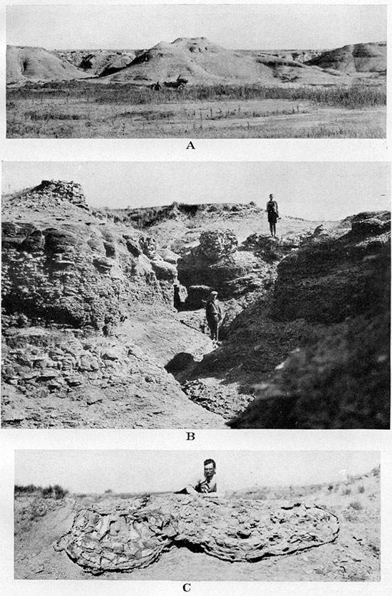
Plate VI--A, Detail view of the structure of a septarian concretion having a crust of crystalline gypsum. From a locality two miles east of McAllaster, Logan County. B, Kidneylike incrustations of the fibrous calcite that constitutes the first crystalline generation of the septarian fissures. Natural size. Negative by Charles Rankin.
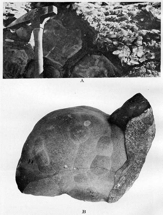
Plate VII--A, "Chop-wood" weathering of cone-in-cone crust around large concentric concretions near the top of Sharon Springs shale member. From a locality two miles east of McAllaster, Logan County. B, Concentric concretions with fibrous gypsum crust and clayey limonite core. Same exposure as A. C, Oval and biscuit-shaped concretions of gray compact limestone in flaky shale in lower part of Upper Sharon Springs shale member. From a locality one mile northeast of McAllaster, Logan County. Shows toadstool weathering of concretions and shale.
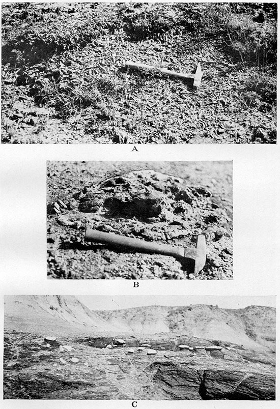
Plate VIII--A, Exposure of Lower Weskan shale member at type locality, in the SW SW, sec. 4, T. 13 S., R. 40 W. White streaks represent bentonite. B, Detail of an exposure at the same locality. C and D, "Perforated" concretions from Lower Weskan shale member in the northwest corner of sec. 24, T. 12 S., R. 38 W.
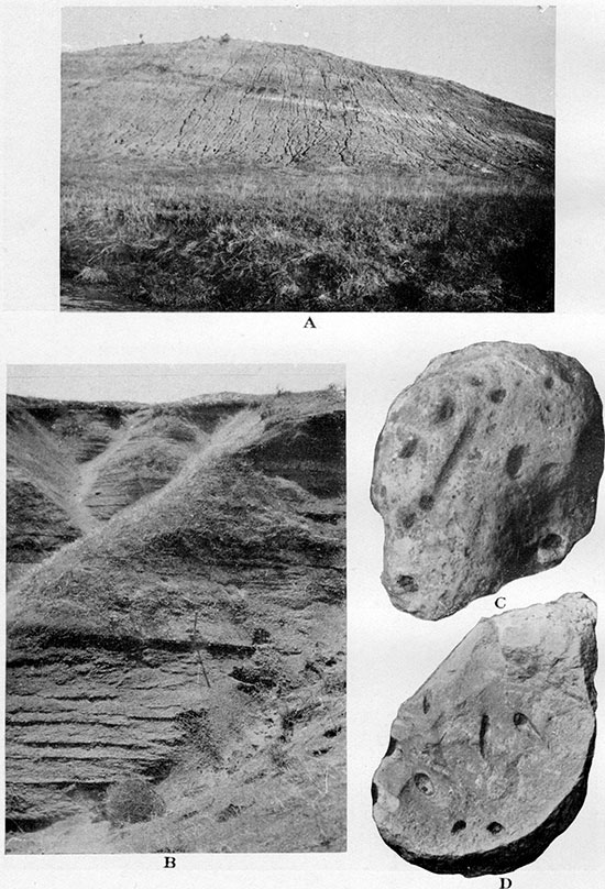
The large limestone concretions of the Lower Weskan shale are chiefly concentrated about 30 feet below the top of the subdivision, which arbitrarily is taken at the base of the lowermost heavy concretionary zone of the Upper Weskan shale. The concretions of the zone 30 feet below the top of the Lower Weskan shale may reach half a foot in thickness and several times as much across, and many contain invertebrate fossils. In the 40 feet of shale below these concretions the principal beds of bentonite, some of them 12 inches thick, are found (Pl. VIII A and VIII B). Limestone and some limonite concretions are scattered through this 40-foot zone. Most of the limonite concretions are dark purple brown, and ordinarily they are densely arranged along bedding planes, thus making almost continuous limonitic streaks. The, lowermost 20 feet of the member consists of an ordinary, featureless, dark-gray shale.
The Lower Weskan shale has less fossils than the Upper, both in number of species and in number of individuals. By far the most common fossil is Anomia cf. subtrigonalis, which is here somewhat larger than the same species from the Upper Weskan shale (Pl. XI A, right side). Occasionally Amauropsis punctata is found together with the Anomia. This gastropod is two or more times larger than the somewhat similar Anchura sublaevis, which is common in the Salt Grass member of the Pierre. Fragments of a moderate-sized Inoceramus are common, and occasionally more complete specimens are found. I. convexus Hall and Meek and I. cripsii var. barabini Morton were identified. Large fragments of Placenticeras meeki Boehm were found but once. It is remarkable that not a single specimen of Ostrea, either free or attached to Inoceramus, has ever been found by the writer in the Lower Weskan shale, whereas O. congesta (Pl. XI A, left side) and O. aff. lugubris were collected in great number from the middle limestone concretionary zone of the Upper Weskan shale, in which they are almost invariably associated with Anomia cf. subtrigonalis, the most common species of both Upper and Lower Weskan shale.
Plate XI--A, Ostrea congesta and Anomia cf. subtrigonalis (at the right) attached to a large and nearly flat Inoceramus shell. From the top of a large limestone concretion of bed No. 8, Upper Weskan shale member, in the center of the NE, sec. 11, T. 13 S., R. 42 W. Slightly enlarged. B, Large concretion of hard compact limestone with skeleton of Platecarpus. From base of Upper Weskan shale member in the northeast corner of sec. 11, T. 13 S., R. 42 W.
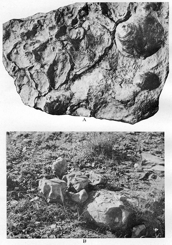
Upper Weskan Shale Member. The Upper Weskan member has three prominent zones of large gray limestone concretions, between which two zones of smaller limonite concretions can be recognized. The upper and lower boundaries of these concretionary zones are, however, not sharp, and the zones vary somewhat in thickness. At the type locality the lowermost zone (beds Nos. 1, 2 and 3) consists of heavy dark-gray limestone concretions, which are arranged chiefly along three bedding planes a few feet apart. The largest concretions are 1 foot thick and some are many times more across. These concretions are not rich in fossils; a few shells of Crassatella evansi, Pteria sp. and very young Baculites sp. and Scaphites sp. were collected. Large ammonites of the Pseudoceratites group, though much scattered, are comparatively common in this zone; Placenticeras meeki and fragments of a very large Placenticeras sp. were identified. Bones of a mosasaur (Pl. XI B) were found by the writer at the base of this zone at the type locality of the member. The bones were later collected by Curtis J. Hesse, of the University of Kansas museum of natural history expedition, in the summer of 1930, and were recognized as a new species of Platecarpus by the late H. T. Martin.
In the lower zone of thin limonite concretions (beds Nos. 4 and 5), which separates the basal limestone concretionary zone from the middle zone of the Upper Weskan shale, fossils are practically absent. Only poorly preserved remains of Baculites sp. and Scaphites sp. were recognized. At the top of this zone was found a very large Inoceramus symmetricus n. sp.
The middle limestone concretionary zone (beds Nos. 6, 7 and 8) of the Upper Weskan shale is by far the most fossiliferous zone of this member of the Pierre. Anomia cf. subtrigonalis, Ostrea congesta (Pl. XI A), and occasionally O. aff. lugubris, can be found in nearly every large dark to light-gray limestone concretion (Pls. X A and X B) of this zone. The oysters are usually attached to large shells of Inoceramus (Pl. XI A), but are also found free, especially Anomia cf. subtrigonalis, and the large shells of Inoceramus sp. are found often without any smaller shells attached (Pl. XI C). The concretions of the zone are usually arranged along the bedding planes of the shale, and in many places three or more horizons of the concretions are observed. The uppermost concretions (bed No. 8) are the richest in fossil content, but in the lower concretions (bed No. 6) a small, round and plump pelecypod Crassatella evansi, which is absent from the upper concretions, was found fairly often. This form persists down to the lower concretionary limestone zone (Placenticeras zone, beds Nos. 4 and 5), as has already been noted. Serpula (?) wallacensis (Pl. XII B) makes its first appearance in the upper concretions of the middle concretionary zone (Ostrea aff. lugubris zone, beds Nos. 6, 7 and 8). In the NW, sec. 18, T. 13 S., R. 41 W., the appearance of Lucina occidentalis in great abundance in the peculiar irregular bodies of cavernous "Lucina limestone" (Pl. XV C) was observed. This is the lowest appearance of the species in the local Pierre. In the ordinary compact dark-gray limestone concretions which were observed in the "Lucina limestone" of the latter locality a well-preserved cast of Baculites pseudovatus n. sp. was found.
Plate XII-A, Long oval concretions in parallel and regular arrangement along a bedding plane of shale on the top of Upper Weskan member at the type locality in the NE NW sec. 11, T. 13 S., R. 42 W. The concretions consist of very tough dark-gray ferruginous limestone and are often "sliced" across into thin and broken plates. B, Serpula ? wallacensis, n. sp., in natural position in shale in the center of the SE, sec. 12, T. 13 S., R. 42 W. The circular fragment in lower right corner is planted to show the characteristic cross section of the fossil. Upper part of Upper Weskan shale member. One-half natural size. Negative by Charles Rankin.
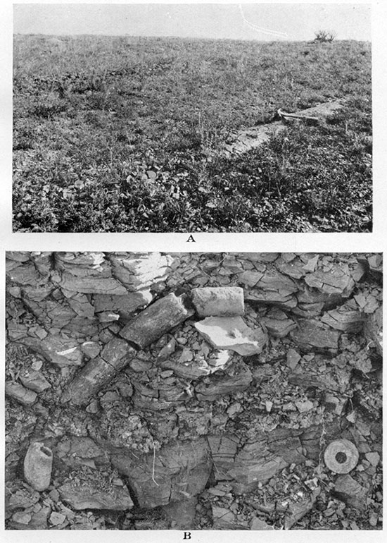
The complete list of fossils from the middle zone of Upper Weskan shale is as follows:
| Invertebrates from the middle zone of the Upper Weskan member |
|---|
| Serpula sp. |
| Serpula (?) wallacensis Elias n. sp. |
| Ostrea congesta Conrad. |
| Ostreo aff. lugubris Conrad. |
| Ostrea plumosa Morton. |
| Anomia cf. subtrigonalis Meek and Hayden. |
| Pecten venustus Morton. |
| Pteria sp, |
| Inoceramus convexus Hall and Meek. |
| Inoceramus proximus Tuomey, Meek em. |
| Inoceramus symmetricus Elias n. sp. |
| Nemodon n. sp. aff. sulcatinus Evans and Shumardt. |
| Nucula planimarginata Meek and Hayden. |
| Nucula n. sp. |
| Crassatella evansi Hall and Meek. |
| Nuculana bisulcata Meek and Hayden. |
| Nuculana sp. |
| Lunatia n. sp. |
| Lucina occidentalis Morton. |
| Dentalium gracile Hall and Meek. |
| Amauropsis punctatus (Gabb). |
| Baculites pseudovatus Elias n. sp. |
| Baculites sp, |
| Scaphites sp. |
| Aptychus sp. |
| Placenticeras meeki Boehm. |
| Tentaculites n. sp. |
A few streaks of bentonite were observed in the middle of Ostrea aff. lugubris zone of the Upper Weskan shale, but none of these streaks is thicker than 1 inch. Some are found directly below the limestone concretions.
The upper limonite zone, which is next above Ostrea aff. lugubris zone, contains many thin concretionary streaks of limonite and few very thin streaks of bentonite. Fossils are not rare in this zone, but only Serpula (?) wallacensis n. sp. (Pl. XII B) was found in profusion here and there. Baculites compressus s. s. was identified from a single specimen. Among other fossils of the zone are a small ovate Baculties ovatus var. haresi and a Scaphites nodosus var. quadrangularis which are not rare but usually fragmentary and too much weathered for the details of septa to be observed. Inoceramus sp. was also found in fragments only. At the base of the zone from one to three ranges of scattered pinkish-brown concretions with cone-in-cone outer crust are present, and these are taken arbitrarily as the lower limit of the zone. A thin streak of bentonite was observed in many places immediately below the topmost cone-in-cone concretions. The cone-in-cone concretions consist of a fine-grained mixture of lime, iron hydroxide and clay, and are softer than ordinary limestone or limonite concretions of the Upper Weskan shale. Where the cone-in-cone outer structure of these concretions is poorly developed or absent, invertebrate fossils are frequently observed, Inoceramus sp., Anomia cf. subtrigonalis and Ostrea congesta being recognized.
The large limy concretions of the type previously described are found occasionally in the shale of the next zone above, where also very often thin bentonite streaks were observed, but only on the top of this uppermost or "barren" zone of Upper Weskan shale are the heavy limestone concretions present in such great number as to form prominent escarpments in the shale. In the type locality, also in some other exposures, the concretions are in the form of very long bodies arranged parallel to each other and lying along the same bedding plane. Thus they make erosional banks consisting of prominent parallel ridges spaced a few feet apart (Pl. XII A). These ridges are about 1 to 1/2 feet across and many times as long and are often "sliced" by close-set parallel cleavages perpendicular to the axes of these bodies.
Somewhat similar and equidistantly spaced, cylindrical concretions have been noticed in a few outcrops of the basal concretionary zone of the Salt Grass member described below. The regular spacing of the concretions along a bedding plane is puzzling. The concretions are elliptical in cross section and can hardly be interpreted as secondary deposition of calcium carbonate along and beyond possible vertical joints in the shale. Their equidistant spacing might be due to wave or current action, and thus they could be classified with pararipples or large ripples with wave lengths measured by feet (Bucher, 1919, p. 258, or Twenhofel, 1926, p. 455). This interpretation of the regular spacing of the concretions of the Pierre formation implies original deposition of a certain amount of calcareous sand, because the supposed ripple marks do not originate in very fine sedimentary material. The pararipples of this sand must have been subsequently recrystallized and somewhat reshaped to form the fine-grained calcareous cylindrical concretions that now appear.
In some exposures the large concretions of the top of the Upper Weskan shale member are crossed by a net of thin veinlets of crystalline light-brown calcite, which makes them resemble slightly the septarian concretions of the Sharon Springs shale. But the calcite veinlets of these concretions never exceed a few millimeters across, whereas the calcite veins of the septarian zone are several centimeters thick. In places an additional horizon of limestone concretions is observed immediately below the topmost heavy and densely spaced concretions of the Upper Weskan shale, and dark purple-brown limonite concretions may be found immediately above this range.
All the heavy concretions are made of very dense dark-gray limestone, probably with a considerable admixture of siderite, which is indicated by the brownish color of the weathered fragments. Fossils are practically absent from this zone, only very small and poor fragments of Inoceramus sp. being occasionally observed. Dark-gray cone-in-cone outer crust, nowhere more than 1 cm. thick, was observed in places around the heavy limestone concretions of the zone.
These densely spaced and heavy dark-gray unfossiliferous topmost concretions and the concretions of the Ostrea aff. lugubris zone, much lighter in color and rich in Inoceramus and oysters, are the best and most easily recognizable keybeds of the Upper Weskan shale.
Distribution of Lower Weskan Member
T. 13 S., R. 40 W. The best exposure of the Lower Weskan shale is in the southwest corner of sec. 4, T. 13 S., R. 40 W., on the south side of Goose creek about 1 mile from the junction of this creek with Smoky Hill river. (Pl. VIII A). The following section was measured here, from top to bottom.
| Section of Lower Weskan member in SW corner, sec. 4, T. 13 S., R. 40 W., Wallace County | Feet. |
|---|---|
| Shale | 3.0 |
| Large and comparatively densely spaced dark-gray limestone concretions with Anomia cf. subtrigonalis, Amauropsis punctatus and Inoceramus sp. | to .6 |
| Shale | .5 |
| Bentonite | .05 |
| Shale | 4.0 |
| Bentonite | .1 |
| Shale | 1.5 |
| Bentonite | .35 |
| Shale | 2.0 |
| Bentonite | .1 |
| Shale | 1.0 |
| Bentonite, gray, not soapy | .5 |
| Bentonite, light gray | .8 |
| Shale with scarce limestone concretions | .3 |
| Bentonite | .1 |
| Shale | 1.0 |
| Scattered limestone concretions | to .2 |
| Shale | 4.5 |
| Bentonite | .1 |
| Shale | 1.2 |
| Scarce limestone concretions | to .2 |
| Shale | .3 |
| Bentonite | .1 |
| Bentonite, gray | .1 |
| Bentonite, white | .8 |
| Shale | 1.0 |
| Limonite, soft, purple-brown, very persistent concretionary streak, occasionally small limestone concretions below | .1 |
| Shale | .5 |
| Scarce limestone concretions | .2 |
| Shale | 2.0 |
| Shale with three thin streaks of bentonite | 1.0 |
| Scarce limestone concretions | .2 |
| Shale | 2.0 |
| Scarce limestone concretions | to .4 |
| Shale | 4.5 |
| Bentonite | .1 |
| Shale with very few "perforated" concretions | 10.0 |
| Limestone concretions | .5 |
| Shale | 5.0 |
| Total | 50.9 |
On the east side the exposure is traversed by a nearly vertical fault, the direction of which is E 11° S. The downthrow is on the eastern side, the displacement being about 12 feet. The shale on the east side of the fault dips 12° S, 30° W; the shale on the west side dips 3 1/2° S, 57° W.
Large fossiliferous limestone concretions belonging apparently to the upper portion of the Lower Weskan shale are exposed immediately below loess in a little canyon on the south side of Smoky Hill river in the northwest corner of sec. 16, T. 13 S., R. 40 W. In these numerous large concretions, which are arranged along bedding planes dipping south at an angle of 2° to 5°, many specimens of Anomia cf. subtrigonalis were collected. Several individuals of Amauropsis punctatus also were found. A good specimen of Inoceramus cripsii var. barabini Morton and a large fragment of Placenticeras meeki Boehm were collected from the limestone concretion at the head of the little canyon.
Other exposures of Lower Weskan shale were studied immediately east of the road on the south side of Smoky Hill river, in the northwest corner of sec. 17, T. 13 S., R. 40 W., and in the NW, sec. 18, of the same township and range. In both of these localities many Anomia cf. subtrigonalis and "perforated" concretions were observed.
T. 13 S., R. 41 W. West of these exposures only the topmost beds of Lower Weskan shale were observed to underlie the Upper Weskan shale in the SW, sec. 10, and in the NW, sec. 18, in T. 13 S., R. 41 W.
T. 13 S., R. 39 W. East of Sharon Springs the Lower Weskan shale is exposed in the SW, sec. 16, T. 13 S., R. 39 W. In the center of this section, on the south side of Pond creek, the septarian zone of Sharon Springs shale, with the observed dip about 2° W, builds an escarpment. West of this escarpment is a small draw, on the western side of which one observes shale with scattered "perforated" concretions and dark purple-brown limonite, and farther west heavy limestone concretions with Anomia cf. subtrigonalis. Inoceramus barabini and Inoceramus sp. are exposed on the very gentle slope of the hill. The same concretions can be seen here and there on the western slopes of Pond creek valley, in the NE, sec. 17, and in sec. 8, T. 13 S., R. 39 W.
Large concretions with the same Anomia were observed in the NE, sec. 1, T. 13 S., R. 39 W., where they outcrop between typical Upper Weskan shale in the NW and the septarian zone of the Sharon Springs shale in the SE of the same section. In the small but beautiful exposure at the county highway in the SW, sec. 31, T. 12 S., R. 38 W., the creamy bentonite about 1 foot thick, accompanied by dark purple-brown limonite concretions, can be seen in the ditch at the base of the exposed section. In about 15 feet of shale above the thick bed of bentonite a few thin streaks of bentonite and a few scattered large limestone concretions were observed. This section is correlated with the middle portion of Lower Weskan shale.
T. 12 S., R. 38 W. The lower portion of the same shale member, having streaks of purple-brown limonite and scattered "perforated" concretions, is exposed immediately above the Sharon Springs shale on the south side of Lake creek near the bridge in the NW, sec. 24, T. 12 S., R. 38 W. The member is exposed, also, in the SW, sec. 13, T. 12 S., R. 38 W.
Upper Weskan Member
T. 13 S., R. 42 W. The Upper Weskan shale, which is undifferentiated from the Lower Weskan on the geologic map, is best exposed in the canyons around Swisegood ranch on Willow creek. The type locality is north of Swisegood ranch, where the complete section of the shale member outcrops at the center of a dome, which is the northern part of the Willow creek anticline. The central part of the dome is traversed by several faults, which put some difficulties in the way of compiling the complete section of the shale member, the beds of which are repeated in the faulted blocks. It appears as if the observed variations in the stratigraphic distances between the various concretionary beds of the member are at least partly due to distortion of the faulted blocks. The estimation of the total thickness of the Upper Weskan shale, which was made on these type exposures, was checked at the exposure in the NW, sec. 18, T. 13 S., R. 41 W. In the type exposures on the west side of the bank of shale that faces Willow creek from the north, in the northeast corner of sec. 11, T. 13 S., R. 42 W., the following beds, which represent the upper half of Upper Weskan shale, are exposed from top down:
| Section of Upper Weskan member in NE corner, sec. 11, T. 13 S., R. 42 W., Wallace County | Feet. |
|---|---|
| Densely spaced heavy concretionary ridges made of dark-gray compact calcium carbonate, probably mixed with siderite; concretionary ridges finely laminated or "sliced" across the axis of the ridges; no fossils except very small fragments of large Inoceramus (bed No. 12) | to 1.2 |
| Scattered heavy concretions of limestone immediately below | to 1.0 |
| Shale, poorly exposed | 16.0 |
| Shale with many streaks of concretionary brown limonite (bed No. 11) | 11.7 |
| Shale | 5.6 |
| Light-brown to pinkish limy concretions with cone-in-cone crust (bed No. 10) | .6 |
| Shale | .5 |
| Bentonite, white | .1 |
| Shale | 5.9 |
| Bentonite (bed No.9) | .2 |
| Shale | 5.7 |
| Heavy gray to light-gray limestone concretions; Anomia cf. subtrigonalis, Ostrea congesta, Inoceramus sp. (bed No. 8) | 1.0 |
| Shale | 7.1 |
| Bentonite | .1 |
| Shale | 4.5 |
| Heavy gray to light-gray limestone concretions (bed No. 7); fossils same as in zone No. 8 but less plentiful | 1.0 |
| Total | 62.2 |
The trend of the concretionary ridges of bed No. 12 at the top of the section is N 50° E.
East of the above section is a fault of about north-south strike, which is concealed by alluvium of a little draw. On the east side of this draw, on the downthrow side of the fault, the following section was measured, from top down:
| Section of Upper Weskan member in W. of sec. 11, T. 13 S., R. 42 W., Wallace County | Feet. |
|---|---|
| Light brown to pinkish concretions occasionally with cone-in-cone crust (bed No. 10) | to .8 |
| Bentonite | .1 |
| Shale | 3.7 |
| Bentonite (bed No. 9) | .05 |
| Shale | 7.30 |
| Heavy gray concretions with Anomia cf. subtrigonalis, Ostrea congesta, Ostrea aff. lugubris and Inoceramus sp. (bed No. 8) | to 1.0 |
| Shale | 6.8 |
| Bentonite | .05 |
| Shale | 7.1 |
| Heavy gray concretions with the same but less plentiful fauna as in bed No. 8 (bed No. 6) | 1.0 |
| Shale | 12.1 |
| Streak of gypsum and rust | 1 |
| Shale | 8.6 |
| Limestone concretions with Inoceramus sp. and Crassatella evansis (bed No. 3) | .8 |
| Shale | 6.5 |
| Bentonite | .1 |
| Shale | 5.5 |
| Limestone concretions | .8 |
| Total | 62.4 |
In the east side of the bank of shale two more faults were observed. All the faults of the group appear to radiate in south and southeast directions, the apparent continuation of the faults being found on the south side of Willow creek in sec. 12, where the beds corresponding to Nos. 7, 8, 9, 10 and 11 were observed. In bed No. 8 of the southwest corner of sec. 12, Ostrea congesta attached to Inoceramus sp. and Anomia cf. subtrigonalis were found, and crusts and kidney like bodies of manganite were observed in the shale near the concretions. In limonite beds No. 11 Scaphites nodosus var. quadrangularis (?), Baculites compressus s. s., B. pseudovatus and Serpula (?) wallacensis were collected.
At the corner of secs. 1, 2, 11 and 12 of T. 13 S., R. 42 W., the complete geologic section of the Upper Weskan shale is exposed, but the uppermost beds of the section are here too closely spaced. This close spacing suggests a local thinning of the upper zones of the shale, which perhaps is not an original condition, but is due to the stretching of the plastic shale in connection with the folding. The section was taken in the southeast corner of sec. 2, where the following beds are exposed from top down:
| Section of Upper Weskan member in SE corner, sec. 2, T. 13 S., R. 42 W., Wallace County | Feet. |
|---|---|
| Heavy, dark-gray limestone concretions. No fossils (bed No. 12) | to 1.0 |
| Shale | 3.0 |
| Shale with several streaks of concretionary limonite (bed No. 11) | 4.5 |
| Shale | 1.75 |
| Light-brown to pinkish concretions with cone-in-cone crust (bed No. 10) | 1.0 |
| Shale | 2.9 |
| Gray limestone concretions | .8 |
| Shale 4.8 | |
| Gray limestone concretions (bed No. 7) | .8 |
| Shale 6.0 | |
| Gray limestone concretions (bed No. 6?) | .3 |
| Shale | .2 |
| Brownish-gray siderite concretions (bed No. 5) | .2 |
| Shale | 5.0 |
| Shale with few streaks of limonite (bed No. 4) | 7.6 |
| Shale | 6.0 |
| Dark-gray limestone concretions with Pteria sp. and fragmentary Inoceramus; fragments of a very large Placenticeras placenta | 1.0 |
| Shale | 3.1 |
| Dark-gray limestone concretions | 1.0 |
| Dark-gray limestone concretions immediately below | .5 |
| Shale | 5.5 |
| Heavy dark-gray limestone concretions; invertebrate fossils very scarce, except Crassatella evansi, Baculites sp., Scaphites sp. The mosasaur Platecarpus n. sp. was found here | 1.0 |
| Total | 57.95 |
The exposures of Upper Weskan shale, in which beds 8 and 7 with their rich oyster fauna are easily recognized, are scattered all around the large northern tributary of Willow creek, which traverses secs. 2, 1 and 12 of T. 13 S., R. 42 W., except at the heads of this tributary creek in the north and west, where Ogallala Tertiary rocks are exposed. In the east part of section 2 the lower portion of Lake creek shale is exposed, also, directly above the heavy concretionary ridges of bed No. 12. Limestone concretions with an oyster fauna were occasionally observed, also, in the NW SW and SE of sec. 11 and in the SW, sec. 12, T. 13 S., R. 42 W., below the prominent escarpment of Ogallala "mortar beds."
On the south side of the prominent divide between Willow creek and Smoky Hill river, east of the Weskan-Kanorado county road, the same concretionary limestone with oysters attached to large Inoceramus shells is exposed in the middle portions of the larger draws and below the basal beds of the Ogallala. A large new species of Inoceramus (I. symmetricus), with no oysters attached, was found in the limonite streak below the limestone concretions in the SW, T. 13 S., R. 42 W., and Crassatella evansi was found in fragments of limestone from a shallow abandoned well in the NE, sec. 23, T. 13 S., R. 42 W. The concretionary limestone with a rich fauna of Anomia cf. subtrigonalis, Ostrea congesta and O. aff. lugubris attached to large Inoceramus shells was the main key bed on which the Willow creek structure was mapped. In the many exposures of a comparatively deep and much-dissected southern dry tributary to Willow creek, which traverses the NE, sec. 13, T. 13 S., R. 42 W., and the NW, sec. 18, T. 13 S., R. 41 W., the whole thickness of Upper Weskan shale outcrops, except the uppermost heavy concretions of bed No. 12 which either was not developed here or has been eroded away. The other zones and beds of the member are typically developed in these exposures. Some local details of these zones are as follows:
At the base of the upper limonite concretionary zone (bed No. 11), in which Serpula (?) wallacensis is very abundant, three ranges of rusty to pinkish lenslike concretions with outer cone-in-cone crust are developed (bed No. 10). The middle limestone concretionary zone (beds Nos. 5 to 8) is quite typically developed with rich oyster fauna in the upper beds (Nos. 7 and 8) and with Crassatella evansi not rare in the lower beds (No. 6).
T. 13 S., R. 41 W. Only in one place, in the exposures of the NW, sec. 18, large irregular bodies of dark-gray to brownish-gray "Lucina limestone" were observed, which represent a local lateral variation of this concretionary zone (the lithologically and partly faunistically similar "Lucina limestone" of the Salt Grass shale member, which is described below, is of a lighter gray color and is much more abundant there). [However, only Lucina occidentalis is the common form in both, the rest of the fossil content being different.] In the ordinary concretions of darkgray and compact limestone that are exposed near by the moderate-sized Baculites pseudovatus n. sp. and Aptychus sp. were collected. Below bed No. 8 and immediately below a large limestone concretion of the lowermost zone of Upper Weskan shale large shells of Placenticeras meeki Boehm were collected.
The limestone concretions, which contain some oysters and Inoceramus, are seen immediately below the "mortar beds" in the beautifully exposed syncline in the west part of sec. 17, T. 13 S., R. 41 W., on the south side of Willow creek.
Heavy ridges of dark-gray limestone concretions of bed No. 12, which dip about 20 or 30 west-northwest, form the western slope of a small hill in the center of sec. 7, T. 13 S., R. 41 W. On a slope east of here and in the stratigraphically lower shale a few limonite concretions and one specimen of Serpula (?) wallacensis, which are indicative of bed No. 11, were observed. Similar concretions are exposed in the SE, sec. 4, T. 13 S., R. 41 W., and the NW, sec. 9, on the sides of a large draw, each exposure being in the vicinity of an abandoned farmhouse; and the lower half of the same shale member and the top of Lower Weskan shale are exposed in the NE, sec. 9, and the NW, sec. 10, T, 13 S., R. 41 W.
T. 13 S., R. 40 W. The upper beds of the shale member are also exposed in the NW, sec. 18, and in S2, sec. 6, T. 13 S., R. 40 W. The latter locality extends into the SE, sec. 1, T. 13 S., R. 41 W.
T. 12 S., R. 40 W. The shale, which outcrops on the south side of Old Maid's Pool, in the northeast corner of sec. 30, T. 12 S., R. 40 W., is provisionally referred to the base of Upper Weskan shale member on the evidence of the heavy dark-gray limestone concretions, in which the fossils are very scant, only young Scaphites sp. being identified.
T. 12 S., R. 39 W. The next exposure of the Upper Weskan shale toward the east is in the southwest corner of sec. 30, T. 12 S., R. 39 W. The large limestone concretions with rich invertebrate fauna build a slope dipping gently northeast on the south side of Pond creek. The following fauna was collected here: Serpula (?) wallacensis, Anomia cf. subtrigonalis, Ostrea congesta, O. aff. lugubris, Pecten venustus, Inoceramus sp. Nuculana bisulcata. The fauna and the lithology indicate beds Nos. 8 and 7 of the middle limestone concretionary or Ostrea aff. lugubris zone of the Upper Weskan shale.
T. 13 S., R. 39 W. In the NW sec. 1, T. 13 S., R. 39 W., on the northeast side of the hill, capped by a prominent knob of Quaternary gravel, limestone concretions with the same type of oyster fauna as in sec. 30, T. 12 S., are exposed, and for a short distance form the dip slope of the hill. This bed of concretionary limestone was traced from here into the S2, sec. 36, T. 12 S., R. 39 W., where the following fauna was collected: . Serpula (?) wallacensis, Anomia cf. subtrigonalis, Ostrea congesta, O. plumosa, Lithophaga (?) sp., Inoceramus sp., and Amauropsis punctatus. Here, also, a very small pteropod of Tentaculites type was found in profusion in some fragments of concretionary limestone.
T. 12 S., R. 38 W. The bed of large dark-gray limestone concretions with thin cone-in-cone crust and no fossils except Serpula (?) wallacensis, which was noted above, is exposed near the base of the Lake creek shale in the northwest corner of sec. 7, T. 12 S., R. 38 W., and probably corresponds to bed No. 12 of the Upper Weskan shale.
T. 11 S., R. 39 W. The beds of this shale member were identified and their fauna collected in many exposures along Lake creek. Coming down the stream we find the first exposures of the member in the W2, sec. 27, and in the NW, sec. 34, T. 11 S., R. 39 W. Here the exposed large dark limestone concretions are traversed with a net of thin veinlets filled with light-brown crystalline calcite and contain only very few fossils. In the exposure immediately south of the road, in the NW, sec. 34, a small fauna was collected in which Anomia cf. subtrigonalis, Ostrea congesta and Inoceramus sp. were identified.
Below these concretions a few streaks of brown concretionary limonite with Serpula (?) wallacensis, Scaphites nodosus and Baculites sp. are exposed.
T. 11 S., R. 38 W. The same large non fossiliferous concretions with veinlets of calcite, which are identified as the topmost bed No. 12 of the Upper Weskan shale, are well exposed around the Robidoux well, which is in the SW, sec. 31, T. 11 S., R. 38 W., but here are also exposed the other zones of the Upper Weskan, which contain a rich and typical fauna (beds No. 8 and No.7) and thus verify the identification of the member. From this locality the following fauna was identified: Anomia cf. subtrigonalis, Ostrea congesta (?), O. aff. lugubris, Inoceramus convexus, Inoceramus sp., Crassatella evansi, Nucula (?) n. sp.
The limestone concretions with this fauna are here only 10 to 15 feet below the bed that is assumed to be bed No. 12 at the top of the Upper Weskan. This and other exposures along Lake creek demonstrate a change in the vertical spacing of limestone concretions in this shale member as compared with the type locality at Swisegood ranch on Willow creek. These changes, which are not surprising in outcrops separated by a distance of about 20 miles, do not affect the general lithologic character of the Upper Weskan shale, which here also has a very typical middle limestone concretionary zone with a rich oyster fauna and a top zone of heavy unfossiliferous limestone concretions. The geology around the Robidoux well is discussed in the chapter on geologic structure of the county.
T. 12 S., R. 38 W. Large outcrops of Upper Weskan shale are in the NE, sec. 16, and in the northwest corner of sec. 15, T. 12 S., R. 38 W. A prominent hill, with an abandoned house on the top, rises here nearly 200 feet above the level of Lake creek and is cut on its north side by deep draws, which are tributary to the creek. The following section was taken in the draw west of the section line between sections 15 and 16 and on the west and upthrow side of the fault, the direction of which is N 280 E. From top down:
| Section of Upper Weskan member in E2, sec. 16, T. 12 S., R. 38 W., Wallace County | Feet. |
|---|---|
| Dark-gray large limestone concretions rich with fauna: Anomia cf. subtrigonalis, Ostrea congesta, O. aff. lugubris, Inoceramus sp., I. proximus (bed No. 8) | .3 |
| Shale | 11 |
| Dark-gray large limestone concretions; same fauna but less abundant (bed No. 7) | .3 |
| Shale | 6.0 |
| Dark-gray large limestone concretions. Rich fauna: Inoceramus sp. with no oysters attached, Nemodon n, sp. aff. sulcatinus, Nucula planimarginata, Nuculana (?) sp., Lunatia n. sp., Dentalium gracile, Scaphites cf. nodosus (bed No. 6) | .3 |
| Shale | 18.0 |
| Streak of gypsum | .1 |
| Shale | |
| Total | 34+ |
The shale dips 6° to N 10° W.
The large unfossiliferous concretions of bed No. 12 are exposed about 25 feet above and west of the section and dip 4 1/2 °S, 85° W. The same bed, No. 12, outcrops on the east or downthrow side of the fault at about the elevation of bed No. 8 on the upthrow side, which places the vertical throw of the fault at about 25 feet. The section of the upper beds of the Upper Weskan shale was taken in the canyon east of the section line between sections 15 and 16, where also the section of the lowermost portion of the Lake Creek shale was measured. The section of Upper Weskan shale is as follows, from top down:
| Section of Upper Weskan member in W2, sec. 15, T. 12 S., R. 38 W., Wallace County | Feet. |
|---|---|
| Shale of Lake Creek member: | |
| Limestone concretions, large, dark gray with veinlets of calcite; vertical cleavage of the "slicing" type; no fossils except few fragments of Inoceramus sp. (bed No. 12) | .4 |
| Shale | 5.0 |
| Bentonite, white | .25 |
| Shale | 2.0 |
| Bentonite, white | .1 |
| Shale | 1.5 |
| Bentonite, white | .05 |
| Shale | 3.0 |
| Rusty bentonite | .05 |
| Shale | 4.0 |
| Gray limestone concretions, weathering into pink; here and there thin cone-in-cone outer crust. Few fossils: Anomia cf. subtrigonalis, large Inoceramus sp. with no oysters attached (bed No. 10?) | .3 |
| Shale | 10.0 |
| Limestone concretions, gray, with Anomia cf. subtrigonalis and Inoceramus sp. (bed No. 8) | .3 |
| Shale | 5.0 |
| Bentonite, white | .35 |
| Shale with numerous but thin streaks of bentonite | 5.0 |
| Total | 37.3 |
In the exposure of shale in the NE, sec. 14, T. 12 S., R. 38 W, on the north side of Lake creek, the fauna, consisting of Ostrea congesta attached to Inoceramus sp., was collected. No large limestone concretions were noticed, but the fauna indicates the middle portion of Upper Weskan shale. Other exposures of shale, the lithology and fauna of which suggest either Upper or Lower Weskan shale, are in the NE, sec. 15 and in the SW, sec. 2, T. 12 S., R. 38 W., where large concretions suggestive of bed No. 12 (see chart, opp. p. 58) of the Upper Weskan shale were observed.
Logan County, T. 11 S., R. 37 W. Exposures of Weskan shale member are found in Logan County, where shale with similar lithology and fauna was observed in a draw west of the north fork of Smoky Hill river, in sec. 27, T. 11 S.; R. 37 W. The shale dips gently to the north. The following fossils were collected and identified: Anomia cf. subtrigonalis, Inoceramus convexus, I. proximus, Dentalium gracile, Baculites cf. compressus.
The possible equivalents of the Weskan shale member of the Pierre outside of Kansas are discussed further on in the chapter.
Lake Creek Shale Member
The Lake Creek shale member of the Pierre differs from the Weskan shale below and from the Salt Grass shale above by the total absence or by great scarcity of the large limestone concretions that are so common in the members above and below. On the other hand, limonite concretions and concretionary streaks are very common through the whole thickness of the member and give a typical rusty appearance to all the exposures of this shale. It must be taken into account, however, that limonite concretionary zones are also common in both Weskan and Salt Grass shale members, where these rusty zones alternate with zones of heavy limestone concretions.
The name of the Lake Creek shale is taken from a stream in the northwest part of Wallace County along which the most extensive outcrops of the shale member are exposed, but the thickness of the member was estimated on the outcrops in sec. 5 and sec. 7 of T. 13 S., R. 41 W., where both the upper contact with Salt Grass shale member and the lower contact with the Weskan shale are observed. Two estimates gave nearly the same amount, about 200 feet.
The sections of Lake Creek shale member are very uniform in appearance and contain innumerable streaks of concretionary limonite, which do not exceed two-tenths of a foot in thickness. Small, usually yellowish-white or light-gray limestone and marl concretions are nearly always mixed with the limonite concretions and concretionary streaks and are often present as an oval core around which a thick limonite crust is deposited. Rarely the white concretions are gathered in pure limy streaks, but a few horizons of thin pancake-like gray to dark-gray limestone concretions are observed in the uppermost Lake Creek shale, and similar but nearly white concretions were observed in the lowermost Lake Creek shale. These limy concretions do not exceed one-tenth of a foot in thickness, and they are comparatively soft, or at any rate they are never as tough as the dark-gray limestone concretions of the Weskan shale. The limonite concretions are usually light to dark brown, but in the Upper Lake Creek shale many are quite yellowish and rusty in appearance. Some acquire a pinkish tint, and there are some concretions, made of compact mixtures of lime and iron hydroxide, which show a pleasant though somewhat dull "strawberry and milk" color. These concretions are also confined to the upper half of the shale member.
Poorly developed cone-in-cone structure was occasionally observed around these concretions, but no good cone-in-cone structures comparable to those of Salt Grass and Weskan shales were noticed in Lake Creek shale. Crystalline gypsum was occasionally met with in various parts of this shale (Pl. XIII B), but bentonite was never observed except in the lowermost beds, where very few and thin streaks were found.
No prominent and reliable key beds could be chosen from among the many concretionary streaks of this shale member. Invertebrate fossils are common through the whole thickness of the Lake Creek shale and help materially to distinguish the upper part of this shale member from the lower part of it, as the lithology of the shale is more or less uniform through the whole thickness. The most common and important index fossil for the lower half of the shale member is Serpula (?) wallacensis, the medium-sized short and often fusiform or pipelike bodies of which are found in places in profusion. Baculites compressus s. s. was mostly found in the Lower Lake Creek shale, whereas in the Upper Lake Creek shale Baculites compressus var. reesidei gradually takes its place. The variety corrugatus of the latter form is restricted to the uppermost Lake Creek shale. In some localities of the northwestern Wallace County area there is a bed of black shale, which is harder than the ordinary shale of the Pierre and contains many rusty streaks and abundant fish bones and scales. This shale is exposed slightly below the lower limestone concretionary zone of the Salt Grass shale member and therefore belongs to the top of the Lake Creek shale.
A complete list of invertebrates of the Lake Creek shale is as follows:
| Invertebrates from the Lake Creek member |
|---|
| Serpula (?) wallacensis Elias n. sp. |
| Serpula kansasensis Elias n. sp. |
| Serpula aff. lineata (Weller). |
| Ostrea cf. congesta Conrad. |
| Anomia cf. subtrigonalis Meek & Hayden. |
| Lithophaga sp. |
| Pteria aff. linguiformis Evans and Shumard. |
| Inoceramus convexus Hall & Meek. |
| Inoceramus proximus Tuomey, Meek em. |
| Inoceramus proximus var. subcircularis Meek. |
| Inoceramus vanuxemi Meek & Hayden. |
| Inoceramus saltgrassensis Elias n. sp. |
| Crassatella evansi Hall & Meek. |
| Thetis circularis Meek & Hayden. |
| Lucina subundata Hall & Meek. |
| Lucina occidentalis Morton. |
| Pholadomia (Procardia) hodgii Meek. |
| Anchura sublaevis Meek & Hayden. |
| Anisomyon centrale Meek. |
| Acmaea cf. parva Meek & Hall. |
| Baculites compressus Say em. Meek. |
| Baculites compressus var. reesidei Elias D. var. |
| Baculites compressus var. corrugatus Elias n. var. |
| Acantoscaphites nodosus Owen. |
| Acantoscaphites nodosus var. brevis Meek. |
| Acantoscaphites nodosus var. quadrangularis Meek & Hall. |
| cf. Discoscaphites constrictus var. tenuistriatus (Kner). |
| Ammonites sp. |
| Placenticeras meeki Boehm. |
| Aptychus sp. |
The vertebrates that were found in this shale member are mentioned in the descriptions of the localities.
Distribution of Lake Creek Member
T. 13 S., R. 42 W. The lowermost 20 to 30 feet of the Lake Creek member are well exposed in the SE, sec. 2, T. 13 S., R. 42 W., where the member overlies the Upper Weskan beds. Many streaks of concretionary limonite, some with cores of white lime, build benches in the Lower Lake Creek shale. Among the fossils, which are not rare, Serpula (?) wallacensis and fragmentary Inoceramus sp. are most common. One specimen of Pholadomia hodgii was found here. Two thin streaks of bentonite were observed at the very base of the exposures.
T. 13 S., R. 41 W. Shale of the same character is poorly exposed in the center of sec. 7, T. 13 S., R. 41 W., where it lies between white limy concretions of the base of Salt Grass member on the west and dark-gray limestone ridges of the top of the Weskan member on the east. The gentle north-northwest dip of the two inclosing beds permits the estimating of the thickness of the shale between them. The basal portion of Lake Creek shale is exposed in the SE, sec. 8, T. 13 S., R. 41 W., and very good and almost continuous exposures of the whole thickness of the shale member lie along the large draw marked by the two abandoned houses in secs. 5,8 and 3 of T. 13 S., R. 41 W. In the northeast corner of section 8, near the very base of the member, the following fossils were collected: Acantoscaphites nodosus var. quadrangularis, Anchura sublaevis, Lithophaga sp. attached to Acantoscaphites, Inoceramus saltgrassensis, Inoceramus sp., Serpula (?) wallacensis, numerous Serpula cf. lineata and vertebrae of a mosasaur. In the upper portion of the shale member, in the NW, sec. 5, T. 13 S., R. 41 W., many specimens of Baculites compressus var. reesidei and especially the large variety corrugatus, roughly corrugated on the siphonal edge, were collected. A little lower in the section fragments of Acantoscaphites nodosus s. s. were found associated with a yellow, rusty limonite streak. Inoceramus sp. fragments were commonly observed. The dip of the shale is invariably northwest, which permitted another estimate of the total thickness of the Lake Creek member. Typical beds of the Lake Creek shale member were observed but not studied in detail at NE, sec. 4, and NW, sec. 3, T. 13 S., R. 41 W., where they underlie the Salt Grass shale member, dipping north, and in the center of sec. 13, T. 13 S., R. 41 W., where the shale dips gently to the south.
T. 13 S., R. 40 W. Lake Creek member was observed at SW, sec. 6, T. 13 S., R. 40 W., and west of sec. 18, T. 13 S., R. 40 W., where it overlies Upper Weskan shale. A lone exposure of probably the lower portion of the member is on the north side of Goose creek, north of the center of sec. 11, T. 13 S., R. 40 W. The shale dips gently south and is overlain by a small thickness of "mortar beds." The following fossils were collected in the shale: Serpula kansasensis, Scaphites nodosus var. quadrangularis, Inoceramus sp. and Acmeae sp. cf. parva.
T. 12 S., R. 41 W. The member is exposed in southeast corner of sec. 27, in southwest corner of sec. 22, in SE and NE, sec. 10, and in NW, sec. 12, T. 12 S., R. 41 W., where the Upper Lake Creek shale underlies the basal limestone concretionary zone of Salt Grass shale member. In the last-named locality several specimens of Baculites compressus var. reesidei and var. corrugatus were collected in the zone of gray limestone pancake-like concretions. In a lone exposure of the upper portion of Lake Creek shale with pancake-like limestone concretions in SE, sec. 33, T. 12 S., R. 41 W., a complete skeleton of the large fish Empo was discovered (Pl. XIII A). The beautiful large rosette of gypsum shown in Pl. XIII B was photographed in the ditch beside the road in the west central part of sec. 11, T. 12 S., R. 41 W., a few feet below the limestone bodies with Lucina shells (Pl. XV C) which belong to the base of the Salt Grass member.
Plate XIII--A, Skeleton of a large fish (Empo sp.) in shale near the top of Lake Creek shale member, in the NE SE, sec. 33, T. 12 S., R. 41 W. B, Rosette of gypsum in shale near the top of Lake Creek shale member, in the SW NW, sec. 11, T. 12 S., R. 41 W. C, Rosettes of gypsum in shale of the lower part of Upper Sharon Springs shale member. From locality two miles east of McAllaster, Logan County.
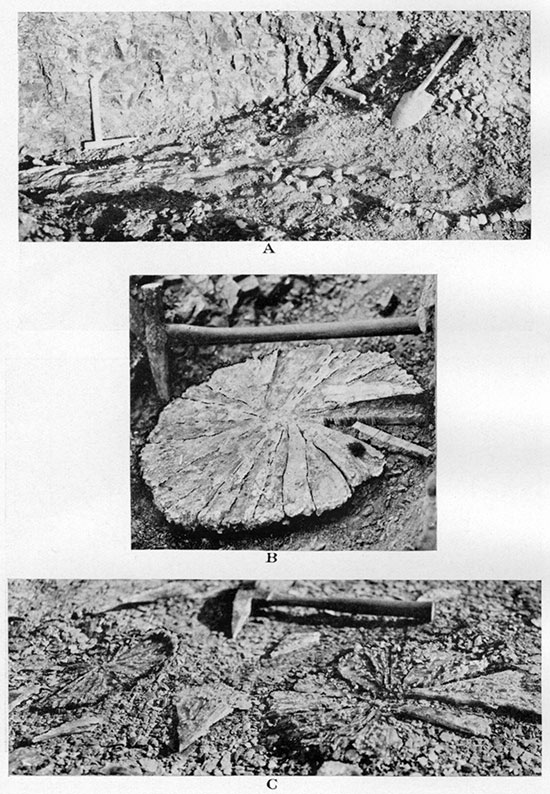
T. 12 S., R. 40 W. Several exposures of the Lake Creek Shale member were studied at the head of the Pond Creek basin, in SE, sec. 23, SW, sec. 24, SW, sec. 13 and in sec. 25 of T. 12 S., R. 40 W. In the uppermost Lake Creek shale, immediately below the basal concretionary zone of the Salt Grass member, in SE, sec. 23, the following fossils were collected: Baculites compressus var. reesidei, Inoceramus saltgrassensis and a vertebra of a mosasaur. In the SW, sec. 24, the same uppermost portion of Lake Creek shale yielded the following forms: Serpula kansasensis, Ostrea cf. congesta, Inoceramus saltgrassensis, I. sp., Anysomion cf. centrale, Baculites compressus var. reesidei, B. compressus s. s. (?), Scaphites nodosus var. brevis, and in sec. 25 Serpula cf. lineata, Baculites compressus var. corrugatus, Placenticeras meeki were collected.
T. 12 S., R. 42 W., and T. 11 S., R. 42 W. The topmost part of the Lake Creek shale member is exposed below the lowermost limestone concretionary zone of the Salt Grass formation in the southwest corner of sec. 36, T. 11 S., R. 42 W., and in the SE NE sec. 2, T. 12 S., R. 42 W. The exposed shale below the limestone concretionary zone of the first exposure is as follows (see, also, Pl. XIX-3):
| Section of Lake Creek member in SW, sec. 36, T. 11 S., R. 42 W., Wallace County | Feet. |
|---|---|
| Large lenticular limestone concretions at the base of Salt Grass shale member | .3 |
| Shale, gray | 4.1 |
| Streaks of limonite concretions | .1 |
| Shale, gray | 2.7 |
| Rusty streak | .05 |
| Shale, gray | 11.2 |
| Bed of rusty limonite | .3 |
| Dark gray to black shale with many rusty streaks and abundant bones and scales of fishes | 6.3 |
| Rusty streak with occasional cone-in-cone structure | .1 |
| Shale | 3.8 |
| Siderite concretions | .1 |
| Shale | 6.5 |
| Siderite concretions | .1 |
| Shale | 3.2 |
| Total | 38.85 |
| For the upper continuation of the section see page 109. | |
In the same uppermost dark shale of the Upper Lake Creek member, which is exposed in the core of the small structural height of Salt Grass canyon, in the NE, sec. 12, T. 12 S., R. 42 W., many rusty streaks and a considerable quantity of crystalline gypsum, often making large rosettes, were observed.
T. 11 S., R. 40 W. The most extensive exposures of Lake Creek shale were observed along Lake creek, or Turtle creek, beginning a little east of state highway No. 27 and extending down the stream. The uppermost beds, having almost no fossils and few thin streaks of rusty limonite and a streak of very flat light-brown cone-in-cone concretions, are exposed in a deep draw in the W2, sec. 35, and in a little draw in the middle south part of sec. 26, T. 11 S., R. 40 W. A little lower bed of the Lake Creek shale is exposed in the SE SW, sec. 25, T. 11 S., R. 40 W. Several streaks of concretionary limonite, pinkish limy concretions and a few very thin bentonite streaks were observed and one specimen of Baculites compressus var. reesidei was collected. The shale is exposed, also, in the NW, sec. 36, T. 11 S., R. 40 W.
T. 11 S., R. 39 W. The Lake Creek member is exposed in the SW, sec. 30, and the NW, sec. 31, T. 11 S., R. 39 W. In these two localities only dark-brown streaks of concretionary limonite and small light-gray. to nearly white limy concretions were observed. Many shells of Inoceramus saltgrassensis and fragments of larger Inoceramus sp. and Scaphites cf. nodosus were collected. In the NW, sec. 29, T. 11 S., R. 39 W., Inoceramus saltgrassensis, I. proximus var. subcircularis and a large I. sp. were collected in similar shale. In the SE, sec. 29, T. 11 S., R. 39 W. B. compressus var. corrugatus was collected by Joe De Tilla and cordially submitted to the writer. The beautiful specimen was made by him the type of var. corrugatus. Good exposures of Lake Creek shale were observed in everyone of the many and short draws on the south side of Lake creek in T. 11 S., R. 39 W. In the SE, sec. 33, the following fossils were collected: Serpula kansasensis, Inoceramus saltgrassensis, I. cf. convexus, Lucina subundata, Anchura sublaevis, Baculites compressus var. reesidei, Scaphites nodosus var. brevis. In the NW, sec. 34, the collected fauna includes Inoceramus convexus, Ostrea cf. congesta, Baculites compressus var. reesidei, Acantoscaphites nodosus s. s. (?). In the middle of sec. 35 and in the west part of sec. 36, T. 11 S., R. 39 W., typical thin pancake-like limy concretions and rusty limonite concretions of the upper Lake Creek shale are exposed. The following fauna belongs to these exposures: In section 35 Inoceramus saltgrassensis, I. sp., Pteria sp. aff. linguiformis, Thetis circularis, Anchura sublaevis, Acme cf. parva, Baculites compressus var. reesidei, Baculites sp. cf. pseudovatus, Acantoscaphites nodosus var. brevis; in section 36 Serpula cf. lineata, Inoceramus convexus, I. vanuxemi, I. saltgrassensis, Lucina occidentalis (a young individual), Baculites compressus var. reesidei, B. compressus var. corrugatus, B. sp. cf. compressus s. s., Acantoscaphites nodosus s. s., Ammonites sp.
On the north side of Lake Creek in the SW, NW, sec. 27, T. 11 S., R. 39 W., streaks of dark purple-brown limonite concretions with white limy cores overlie the heavy limestone concretions of the Upper Weskan shale. In the shale which apparently represents the lowermost beds of the Lake Creek member the following fossils were collected: Serpula (?) wallacensis, S. cf. lineata, Inoceramus proximus, Baculites sp. cf. compressus s. s.
T. 11 S., R. 38 W. Lowermost beds of Lake Creek shale are exposed above the Weskan shale at the Robidoux well, in the SW, sec. 31, T. 11 S., R. 38 W. The following fossils were collected: Serpula (?) wallacensis, Baculites sp. cf. pseudovatus, Acantoscaphites nodosus var. quadrangularis, Placenticeras sp. and Mosasaurus ribs.
T. 12 S., R. 39 W., and T. 12 S., R. 38 W. Many good exposures of Lake Creek shale are located on each side of the large southern tributary to Lake Creek in secs. 1, 2, 11 and 12, T. 12 S., R. 39 W., and in secs. 7 and 18, T. 12 S., R. 38 W. The shale that is exposed in the southwest corner of sec. 7, T. 12 S., R. 38 W., contains brown limonite concretions with thin yellow rusty crust and small flat oval limy concretions. Among the collected fossils the following forms were recognized: Serpula cf. lineata, Inoceramus cf. proximus, Lucina cf. subundata, Baculites compressus s. s., B. compressus var. reesidei. North of this exposure, in the northwest corner of sec. 7, T. 12 S., R. 38 W., in the ditch beside the county road large darkgray limestone concretions with a thin cone-in-cone crust are exposed with a streak of purple-brown limonite below. Serpula (?) wallacensis was found in the shale at the top of the exposure. This is probably the topmost bed, No. 12, of Upper Weskan shale and the overlying shale belongs to the base of the Lake Creek member. In the exposure in the N2, sec. 12, T. 12 S., R. 39 W., the following fossils were collected: Serpula cf. lineata, S. (?) wallacensis, Inoceramus cf. proximus, Baculites compressus var. corrugatus. In the center of sec. 2, T. 12 S., R. 39 W., Acantoscaphites nodosus var. quadrangularis and Baculites compressus var. reesidei were found. The shale of the last two sections probably belongs to the middle portion of the Lake Creek member. The shale exposed in the northeast corner of sec. 11, T. 12 S., R. 39 W., contains many flat oval white limestone concretions with Ostrea cf. congesta, Inoceramus sp. and Acantoscaphites nodosus var. brevis, and probably belongs to the higher beds of the Lake Creek member. To the upper beds. of the Lake Creek member belongs, also, the shale exposed in the S2, sec. 7, and in the N2, sec. 18, T. 12 S., R. 38 W., where the following fossils were collected: Serpula (?) wallacensis, S. cf. lineata, Anomia cf. subtrigonalis, Inoceramus saltgrassensis, I. sp., Thetis circularis, Pholadomia (Procardia) hodgii, Baculites compressus var. corrugatus, B. sp., and Scaphites sp.
A section of Lower Lake Creek shale was measured in the exposures at the head of a deep but short canyon in the northwest corner of sec. 15, T. 12 S., R. 38 W., where this shale is underlain by the Upper Weskan member. The following beds of the Lake Creek shale are exposed from top to bottom.
| Section of Lake Creek member in NW corner sec. 15, T. 12 S., R. 38 W., Wallace County | Feet. |
|---|---|
| Shale with few small limonite and white limestone concretions | 10.0 |
| Shale with streaks of small brown limonite and white limestone concretions on top; fragments of Inoceramus sp., Baculites cf. compressus s.s. and B. cf. pseudovatus | 15.0 |
| Streaks of brown limonite concretions with Serpula (?) wallacensis | .1 |
| Shale with two thin streaks of rust | 7.0 |
| Scattered brown to dark-gray concretions with thin crust of cone-in-cone structure | .2 |
| Shale with many streaks of brown concretionary limonite with white limy cores. Abundant Serpula (?) wallacensis, also Inoceramus sp. and Scaphites sp. | 8.0 |
| Very persistent streak of dark-brown limonite and gray to white limestone concretions | .2 |
| Shale with few limonite concretions | 14.0 |
| Large concretions of dark-gray limestone on top of Weskan shale. |
Beds of the Lake Creek member are also exposed at the head of Buckskin creek in the NW, sec. 3, T. 12 S., R. 38 W., and in the SE, sec. 30, T. 11 S., R. 38 W. In sec. 2, T. 12 S., R. 38 W., Baculites compressus var. corrugatus was found.
T. 11 S., R. 38 W. The shale of this member outcrops, also, occasionally on the south side of the north fork of Smoky Hill river in the northeast corner of T. 11 S., R. 38 W. Here in the shale with many streaks of concretionary limonite having occasional imperfect cone-in-cone crust, Baculites compressus var. reesidei and Scaphites sp. were found. In the exposure of similar limonite concretionary beds at the county line in the E2, sec. 12, T. 11 S., R. 38 W., the following fossils were collected: Serpula cf. lineata, S. (?) wallacensis, Inoceramus sp., Baculites compressus var. reesidei and var. corrugatus and bones of a mosasaur. Small concretions of manganite in crystalline kidneylike forms were found in a number. The shale of this exposure probably belongs to the middle part of the Lake Creek member.
The possible equivalents of the Lake Creek shale member outside of Kansas are discussed farther on in this chapter.
Salt Grass Shale Member
The name of this member is derived from Salt Grass Canyon, the southern tributary to Goose creek in secs. 1 and 12, T. 12 S., R. 42 W. Many exposures of the shale member on both sides of the broad and not very steep canyon permit study of the zones and beds of the member in detail. The average thickness of the member estimated in this locality is about 60 feet. The shale is lighter in color than the dark-gray to black shale of the top of the Lake Creek member. The Salt Grass shale can be conveniently subdivided into three zones: The lowest zone contains large limestone concretions (Pl. XV) in which occasionally a rich fauna of cephalopods and pelecypods is observed; the middle zone has many streaks of concretionary limonite with white limy cores containing abundant Baculites but practically no other fossils; and the upper zone has beautifully developed cone-in-cone concretions of rusty limestone (Pl. XVI E) and small septarian cores in concretions of limonite (Pl. XVI A), practically bare of fossils. In some exposures above these beds about 30 feet more of shale is exposed on the top of the upper zone. This 30 feet of shale is nearly featureless. No fossils were found, and only a few thin streaks of ordinary rusty limonite were noticed in this shale.
Plate XV--A, Zone of gray to white limestone concretions at the base of Salt Grass shale member in the southwest corner of sec. 6, T. 13 S., R. 41 W. B, "Lucina limestone" in a columnar body near the base of Salt Grass shale member. From a ditch on the east side of the road, in the SW NW, sec. 11, T. 12 S., R. 41 W. C, Casts of Lucina occidentalis in cavernous "Lucina limestone." From the NW NW, sec. 3, T. 13 S., R. 41 W. Natural size. D, Cast of Baculites compressus var. reesidei on the top of a large limestone concretion near the base of Salt Grass shale member. From the NW NE, sec. 3, T. 12 S., R. 42 W.
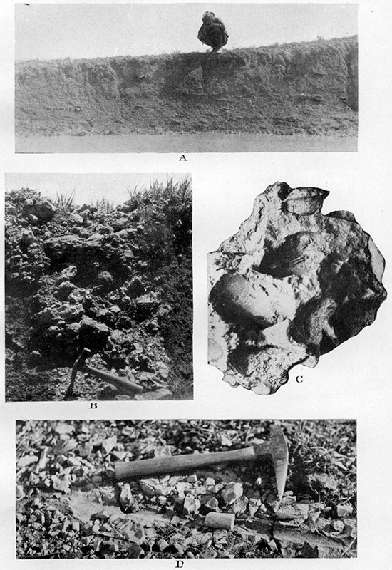
Plate XVI--A, Limonite concretion with a septarian core of calcareous limonite and with veinlets of calcite. Natural size. From the upper zone of Salt Grass shale member in the NE, sec. 12, T. 12 S., R. 42 W.
Rusty marl concretions with cone-in-cone structure. From the upper zone of Salt Grass shale member in the same locality: B, Craterlike depressions in place of fallen-out or weathered cones. Six-tenths natural size. C and D, Cone-in-cone structure broken across; cones are on the piece above (C) and their impressions on the piece below (D). Natural size. E, Lenslike concretion with cone-in-cone structure throughout, except in the core.
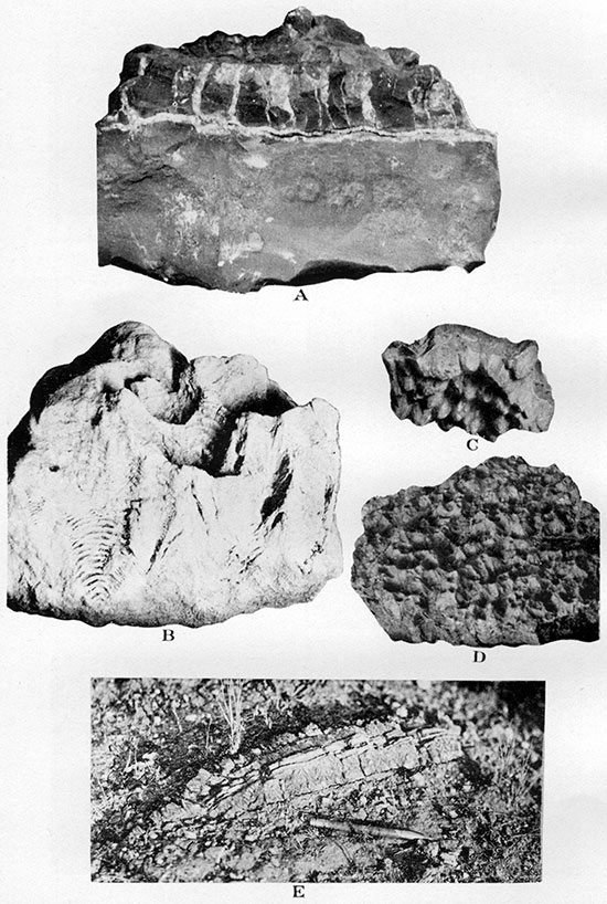
The lowest zone of the Salt Grass shale member in many places contains several layers of light-gray to nearly white limestone concretions, to which rarely a few smaller streaks of limonite concretions are added. The limestone of the concretions is fine-grained and compact and often contains no fossils at all. Occasionally, however, the fossils appear in a considerable number of specimens, usually on the top (Pl. XV D) or at the base of the concretions. The concretions are commonly oval in outline (Pl. XV A), flattened horizontally and traversed by many vertical cracks. Among these ordinary concretions there appear in places larger irregular bodies of limestone in which Lucina occidentalis (Pl. XV C) is very abundant. The limestone of these bodies is full of irregular veinlets which are partly or completely filled with yellowish crystalline calcite, The weathered surface of this limestone is quite rough.
Many of these peculiar bodies of limestone are elongated vertically (Pl. XV B). Similar and still larger bodies from Pierre of the Arkansas valley in eastern Colorado were originally described by Gilbert and Gulliver as "tepee cores," so named on account of the position of each core of limestone in a "conical hill of shale, with the limestone projecting slightly at top" (Gilbert, 1896, p. 669; see, also, Gilbert and. Gulliver, 1896). This limestone is also full of Lucina occidentalis shells, which are believed to be the main source of the calcium carbonate of the "tepee cores." The corresponding limestone bodies in the Pierre of Wallace County only rarely occur as cores of isolated conical hills resembling Indian tepees, but usually appear in horizontally spaced groups and form somewhat irregular benches and escarpments on the slopes of the hills. They can be conveniently called "Lucina limestone" from their content of Lucina shells, other fossils being found in these bodies in comparatively small number. "Lucina limestone" was rarely found in the other zones of the local Pierre, where it appears, also, as a local lateral change in the limestone concretionary zones. The sole outcrop of the similar "Lucina limestone" in the middle concretionary limestone zone of the Ostrea aff. lugubris zone of the Upper Weskan shale member has been described already. In the upper limestone zone of the Salt Grass member, also, "Lucina limestone" bodies were observed only once. Similar limestone occurs also in places near the top of the uppermost shale of the Pierre exposed at Beecher Island, Yuma county, Colorado.
Some large limestone concretions of the lowest limestone zone of the Salt Grass have a crust of cone-in-cone structure, but the cone-forming arrangement of the crystalline fibers in this crust is not pronounced, the fibers being nearly parallel. Owing to this the cone-in-cone crust weathers into debris like "chopwood" (Pl. XVIII D), somewhat similar to the structure around some concretions at the top of the Sharon Springs shale member (Pl. VII A).
In a few concretions Lingula sp. and scales and bones of small fishes were collected. The following is a complete list of invertebrates collected from the lower limestone concretionary zone of the Salt Grass shale member:
| Invertebrates from the lower zone of the Salt Grass member |
|---|
| Serpula kansasensis Elias n. sp. |
| Lingula sp. |
| Inoceramus vanuxemi (?) Meek and Hayden. |
| Inoceramus barabini Morton. |
| Inoceramus saltgrassensis Elias n. sp. |
| Yoldia evansi Meek and Hayden. |
| Yoldia scitula Meek and Hayden. |
| Lucina occidentalis Morton. |
| Lucina subundata Hall and Meek. |
| Anchura sublaevis Meek and Hayden. |
| Baculites compressus var. reesidei Elias n. var. |
| Baculites compressus var. corrugatus Elias n. var. |
| Baculites pseudovatus var. A, Elias n. var. |
| Acantoscaphites nodosus Owen. |
| Acantoscaphites nodosus var. brevis Meek. |
| Acantoscaphites nodosus var. quadrangularis Meek. |
| Scaphites plenus Meek and Hayden. |
| Scaphites reesidei Wade. |
The middle concretionary zone of the Salt Grass shale is characterized by small limonite concretions arranged in several streaks and usually with creamy to white limy oval cores. Some of these cores are made by casts of Baculites, which is the only fossil very common in the zone. The limonite of the concretions is usually a uniform light brown, differing from the commonly observed dark-brown, pinkish-brown and yellow colors of the limonite of the Lake Creek shale member. A very thin streak of bentonite at the base of the middle concretionary zone and a much thicker one at the top of the zone are locally observed, but altogether bentonite is rarely found in this shale member. Among the Baculites casts, which are confined mostly to the upper two streaks of concretionary limonite, the following two species were recognized: Baculites pseudovatus var. A (very common), B. compressus var. reesidei (rare). The most common casts, which have an ovate cross section, smooth surface and show no septa, must belong to B. pseudovatus and not to B. ovatus, the typical suture of ovatus never being observed on these specimens. Among other fossils which are only rarely found in this middle zone, the following species are recognized: Pecten venustus Morton, Valvata cf. subumbilicata Meek & Hayden, Aptychus sp.
The highest zone of the Salt Grass shale consists of several streaks, which for the most part have a rusty appearance, but locally change to more limy material and in a few places into nearly pure limestone. One to three closely spaced layers of flat and usually round lenses of cone-in-cone rusty brownish limestone (Pls. XIII, XIV and XV) constitute the most persistent streaks in the middle of the zone. In many places these cone-in-cone lenses form prominent escarpments and benches in the shale, providing the best key bed of the member. Above the cone-in-cone bed, but sometimes also below it, appear one to two streaks of limonite concretions with thin lens like septarian cores of light-brown to cream-colored marly material. These cores are perpendicularly broken into angular fragments, which are partly cemented together by crystalline calcite (Pl. XVI A). The concretionary streaks above the cone-in-cone bed are considered to be the topmost beds of Salt Grass member.
Plate XIV--Geologic sections of Weskan and Lake Creek members.
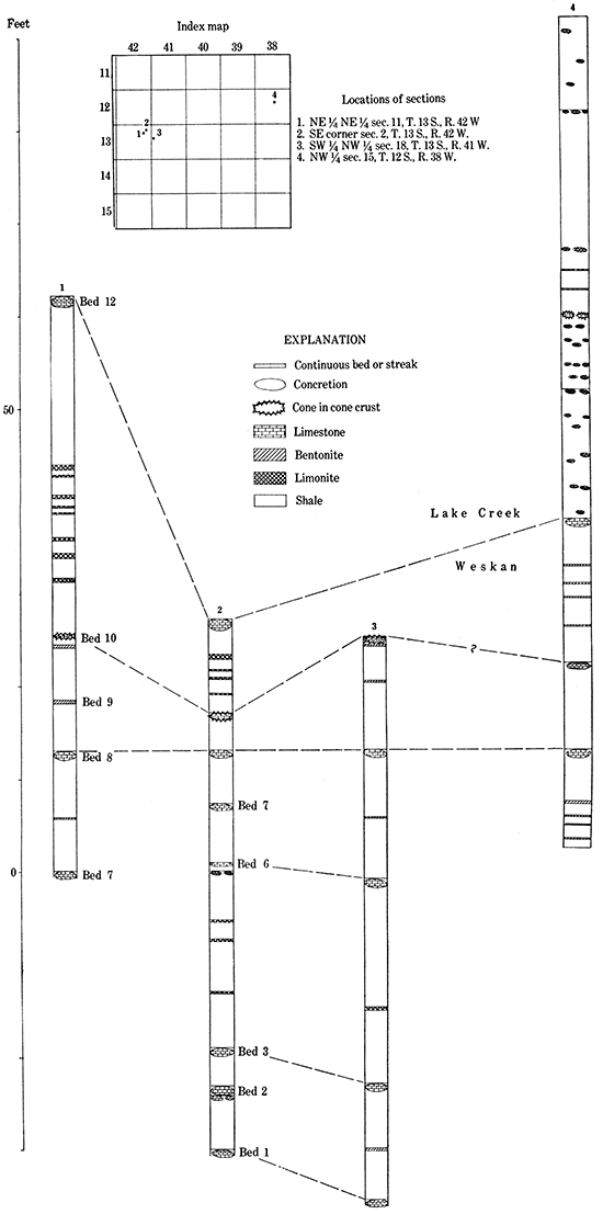
Fossils are exceptionally scarce in the highest zone of the shale member, but in one locality in Roy Johnston canyon, where a graduallateral change of cone-in-cone bed into "Lucina limestone" was observed, a collection of fossils was made among which the following species were recognized:
| Fossils from the top of the Salt Grass member |
|---|
| Serpula kansasensis Elias n. sp. |
| Serpula cf. lineata (Weller). |
| Pteria aff. linguiformis Evans & Shumard. |
| Lucina occidentalis Morton. |
| Baculites sp. |
| Discoscaphites nicolleti var. saltgrassensis Elias n. var. |
In another exposure of the member fossil wood of a conifer with burrows of Teredo sp. was collected. Bones of mosasaurs were also occasionally collected.
The shale of the Salt Grass member often has a light greenish tint, which is probably due to an ancient, pre-Ogallala weathering.
The writer has had an opportunity to study the cuttings of Pierre shale from a deep well in the Beecher Island area, from which he extracted and identified several specimens of foraminifera. The total thickness of the complete Pierre section in this locality is about 1,450 feet. The following foraminifera which were collected from the shale between 735 feet and 790 feet, or slightly below the middle of the section, must belong to a zone approximately corresponding to the Salt Grass shale of the Pierre in Wallace County.
| Foraminifera from the Salt Grass member |
|---|
| Nodosaria communis d'Orbigny. |
| Nodosaria obliqua Linney. |
| Globigerina rosetta Carsey. |
| Orbitolina sp. |
| Rubulus (Cristellaria) cultratus (Montfort). |
Distribution of Salt Grass Member
Salt Grass shale is widely distributed in the northwestern part of Wallace County, and though the member is less than one-third as thick as the underlying Lake Creek shale, it outcrops over a larger area than the latter member. This appears to be due to the stronger resistance to weathering offered by the Salt Grass shale member which is reinforced by the heavy concretionary limestone zones. This shale apparently was the capping rock of the hills and divides of the pre-Ogallala topography. The next zone below it in the Pierre section that resists weathering well is the Weskan shale, that is also reinforced with heavy limestone concretions. The Weskan shale capped the pre-Ogallala hills south and southeast of the area of distribution of the Salt Grass member.
Goose Creek, T. 11 S., R. 42 W. The following outcrops of the Salt Grass shale were studied along the upper part of Goose Creek basin. In T. 11 S., R. 42 W., in the center of section 33, cone-in-cone lenses of the upper zone; in W2, sec. 34, the same bed and overlying shale with rusty streaks of limonite; in S2, sec. 27, fiat large limestone concretions of the lower zone; in SE NE, sec. 34, same limestone concretions; in NE SE, sec. 34, cone-in-cone lenses and overlying septarian marl concretions; in southwest corner of sec. 36 a large exposure of shale with the lower zone of limestone concretions on the top. The fault that throws the shale of the eastern part of this exposure down, crosses the exposure in about the middle, and its strike probably is about north-south. The dip of the shale is 2° to 3° northeast. The following section was measured from top to bottom:
| Section of the Salt Grass member at SW corner sec. 36, T. 11 S., R. 42 W., Wallace County | Feet. |
|---|---|
| Shale | 1.0 |
| Scattered limestone concretions with Baculites pseudovatus var. A. | .2 |
| Shale | 2.6 |
| Scattered limestone concretions | .2 |
| Shale | 1.8 |
| Large lenticular concretions made of tough gray limestone | .3 |
The shale below belongs to the uppermost beds of Lake Creek member; for the continuation of the section see page 97.
At the head of the large northern tributary to Goose creek in the NE sec. 25, rusty cone-in-cone lenses and septarian marl concretions are exposed.
T. 12 S., R. 42 W. The exposures in T. 12 S., R. 42 W., are in NW and in SE, sec. 3, cone-in-cone lenses of the upper zone, and in NE, sec. 3, large limestone concretions of the lower zone with Baculites cf. pseudovatus, B. compressus var. reesidei, Lingula sp. and small fish scales. On the right side of the mouth of the Roy Johnston canyon the same limestone concretions are exposed, above which outcrops the middle zone with streaks of limonite concretions having white limy cores. Here, also, Baculites pseudovatus var. A was recognized. Farther up the canyon the limestone concretions of the lower zone of the member cease to outcrop and only the middle limonite zone and the upper zone with cone-in-cone rusty lenses and septarian marl concretions are exposed. A little south of the center of section 2 there is a very interesting exposure on a small hill near the bottom of the draw. Here one can observe a gradual change of the regular rusty cone-in-cone lenses of the upper zone of the member into somewhat rounded large bodies of "Lucina limestone." The bodies of "Lucina limestone" of the western part of the exposures decrease in size and become nearly spherical toward the east, and a crust of cone-in-cone structure appears around them. Farther toward the southeast and south the limestone bodies decrease still more in size and flatten horizontally and at the same time become rusty instead of light gray with a more intensively developed cone-in-cone crust. The appearance of septarian marl concretions above the same cone-in-cone bed in the near-by exposures verifies the identification of the upper zone of the Salt Grass member. The fossils collected in the "Lucina limestone" at the locality and in the accompanying smaller limestone concretions of the zone have been listed already in the general description of the upper zone of the member (p. 104). On the east side in the lower part of the next southern tributary to Goose creek, which is called Camp Canyon, in the NW, sec. 1, the middle limonite zone of the member with Baculites pseudovatus var. A was observed. Farther up the east side of the canyon, in the SW, sec. 1, the limestone concretions of the lower zone are exposed.
Many exposures were studied and measured around the Salt Grass canyon, the type locality of the shale member, which is in the SE, sec. 1, and in the E2, sec. 12, T. 12 S., R. 42 W. In the left fork of the canyon in the NW NE, sec. 12, the upper zone with two cone-in-cone layers and two septarian marl layers above are exposed. Here the fossil wood with Teredo burrows was collected. Farther up the left side of the main canyon the middle and lower zones of the member gradually appear toward the crest of the local minor "Salt Grass structure." In the "Lucina limestone" exposed near the top of the anticline Baculites compressus var. reesidei was collected, and in the middle zone of the limonite concretions which are exposed farther south Baculites pseudovatus var. A, Pecten vanustus and Valvata cf. subumbilicata were found. The following section, which represents the upper half of the Salt Grass shale, was measured in NW NE, sec. 12, from top down:
| Section of Salt Grass member in NW NE, sec. 12, T. 12 S., R. 42 W., Wallace County | Feet. |
|---|---|
| Limonite concretionary streak | .1 |
| Shale | 4.5 |
| Rusty streak | .05 |
| Shale | 1.0 |
| Septarian marl and limonite concretionary streak | .1 |
| Shale | 2.5 |
| Septarian marl and limonite, concretionary streak | .1 |
| Shale | 2.5 |
| Cone-in-cone rusty bed | .1 |
| Shale | 1.0 |
| Large round cone-in-cone lenses made of rusty limestone | .25 |
| Shale | 2.1 |
| Laminated, rusty limestone streak | .1 |
| Shale | 3.1 |
| Rusty streak | .05 |
| Shale | 1.0 |
| Limonite concretions | .1 |
| Shale | 5.0 |
| Streak of laminated, rusty limestone changing laterally to limonite | .2 |
| Shale | 2.3 |
| Small limestone concretions | .2 |
| Shale | 2.0 |
Farther south, on the west side of the draw, on the south or downthrow side of the fault which traverses the canyon and crosses the apex of Salt Grass anticline, the following section of the lower half of the Salt Grass shale was measured:
| Section of Salt Grass member in SW NE, sec. 12, T. 12 S., R. 42 W., Wallace County | Feet. |
|---|---|
| Shale | .5 |
| Small limestone concretions | .15 |
| Shale | 2.1 |
| Small limestone concretions | .1 |
| Shale | 1.8 |
| Bentonite, light-brown to light-gray | .8 |
| Shale | 1.5 |
| Limonite concretionary streak | .1 |
| Shale | 1.7 |
| Limonite concretionary streak with abundant Baculites pseudovatus var. A. | 15 |
| Shale | 2.5 |
| Limonite concretionary streak | .1 |
| Shale | 4.2 |
| Limonite concretionary streak | .1 |
| Shale | 2.1 |
| Limonite concretionary streak | .1 |
| Shale | 5.2 |
| Bentonite | .05 |
| Shale | 7.5 |
| Large limestone concretions | .2 |
| Shale | 1.3 |
| Streak of gypsum | .05 |
| Shale | 1.0 |
| Total | 36.30 |
At the head of the canyon, in the SE, sec. 12, only poor exposures of the upper zone of the member were observed. On the east side of the canyon a complete section of the member is exposed on the northern or upthrow side of the above-mentioned fault. The following section was measured:
| Section of Salt Grass member in SE, NE, sec. 12, T. 12 S., R. 42 W., Wallace County | Feet. |
|---|---|
| Shale | 13.8 |
| Rusty limestone with cone-in-cone structure | .15 |
| Shale | 8.0 |
| Shale with streaks of gypsum | .2 |
| Limonite concretions | .2 |
| Shale | 7.1 |
| Limonite concretions | .2 |
| Shale | 4.3 |
| Bentonite, light-gray to brown | .8 |
| Streak of gypsum and rust | .2 |
| Shale | 3.9 |
| Limonite concretions with limy cores. Abundant Baculites pseudovatus var. A | .25 |
| Shale | 6.7 |
| Limonite concretions | .15 |
| Shale | 12.1 |
| Large concretions with soft limy core and outer crust made of manganite, rust and gypsum | .6 |
| Shale | 1.5 |
| Limestone concretions, lateral change to north to thinner but almost continuous limestone streak with light-gray to creamy cone-in-cone structure. Weathered to "chopwood" | .3 |
| Shale | 3.8 |
| Thick streak of crystalline gypsum | 8.0 |
| Total | 72.3 |
| The last three beds belong to the top of the Lake Creek shale member. | |
Another nearly complete section of the member was measured on the prominent hill in the northeast corner of section 12 opposite the large left tributary of Salt Grass canyon. The following beds are exposed:
| Section of the Salt Grass member at NE NE, sec. 12, T. 12 S., R. 42 W., Wallace County | Feet. |
|---|---|
| Loam of Ogallala formation | |
| Streak of rusty limonite | .05 |
| Shale | 2.5 |
| Septarian marl and limonite concretions | .1 |
| Shale | 3.1 |
| Septarian marl and limonite concretions | .1 |
| Shale | 3.8 |
| Rusty limestone streak, laterally changing to cone-in-cone structure | .2 |
| Shale | 3.8 |
| Large round lenses of rusty limonite with cone-in-cone structure | .2 |
| Shale | 2.7 |
| Rusty limestone streak, laterally changing to cone-in-cone structure | .2 |
| Shale | 3.5 |
| Limonite concretions | .1 |
| Limonite concretions almost immediately below | .1 |
| Shale | .2 |
| Limonite concretions with coral-like structure | .1 |
| Shale | 2.5 |
| Limonite concretions | .1 |
| Shale | 3.25 |
| Limonite concretions, here and there Baculites pseudovatus var. A | .1 |
| Shale | 1.45 |
| Limonite concretions | .1 |
| Shale | 2.9 |
| Limonite concretions | .1 |
| Shale | 11.7 |
| Limonite concretions | .1 |
| Shale | 7.5 |
| Rusty limestone with cone-in-cone structure | .2 |
| Total | 50.75 |
The upper zone with cone-in-cone lenses of rusty limestone and the lower zone with large light-gray limestone concretions are exposed in places on the eastern side, down the canyon.
T. 11 S., R. 41 W. In T. 11 S., R. 41 W., the Salt Grass shale exposures were observed in the southwest corner, in the center and in the northwest corner of section 31. In the best locality, in the center of section 31, a complete typical section is exposed, the beds here dipping south about 1° to 2°.
T. 12 S., R. 41 W. In T. 12 S., R. 41 W., on the south side of Goose creek, the beds of Salt Grass shale are exposed in places beneath the prominent escarpments of the Ogallala "mortar beds." In the small canyon in the SE SW, sec. 6, the lower limestone concretionary zone and the overlying beds are exposed, and farther northeast, on the right side of the canyon, heavy cone-in-cone structures of the upper zone were observed.
"Lucina limestone" of the lower zone is exposed on both sides of the county road about half a mile south of Goose creek in sections 10 and 11 (Pl. XV B) . The beds dip north more gently than the slope of the hill. The limestone concretions of the same zone outcrop at the head of the little draw west of the road, in the southeast corner of section 10, where also overlying limonite concretions with many Baculites pseudovatus var. A are exposed.
The whole thickness of the Salt Grass member is exposed in the NW, sec. 12, on the left side of Goose creek, opposite Halsey school. Here the limestone concretions of the lower zone of the member are in the form of large parallel cylindrical bodies which extend north 26° east. The dip of the bed that forms an escarpment is 3° north.
Collins draw. T. 12 S., R. 42 W. The Salt Grass member is well exposed along the whole length of Collins draw. In T. 12 S., R. 42 W., the upper zone with cone-in-cone lenses of the rusty limestone and the underlying limonite beds with Baculites pseudovatus var. A. are exposed on the southwest side of the draw in sections 14,13 and 24.
T. 12 S., R. 41 W. In T. 12 S., R. 41 W., the same beds of the member are exposed in the NW SW, sec. 19, in the NE NW sec. 29, and in the NW sec. 28. In the large exposure in the southwest corner of section 22 the lower zone of limestone concretions, occasionally with cone-in-cone crust, was observed. Serpula kansasensis, Inoceramus saltgrassensis and Acantoecaphites nodosus var. brevis and var. quadrangularis were collected. In the central part of section 27 many exposures of the Salt Grass member beneath the prominent escarpments of Ogallala "mortar beds" were observed. In the north and northwest parts the lenses of cone-in-cone rusty limestone of the upper zone outcrop, and in the NE SW, section 27, the beds of septarian marl and limonite concretions were noted below the cone-in-cone concretions, which is the reverse of their normal position above the cone-in-cone beds. On the east or upthrow side of the fault, which traverses the shale in about the north-northeast direction but does not affect the overlying beds of Ogallala, the limestone concretions of the lower zone of the member are nearly continuously exposed along the foothills for about a quarter of a mile. Locally larger bodies of "Lucina limestone" were observed.
Draw marked by abandoned schoolhouse. T. 12 S., R. 41 W. In the "Schoolhouse" draw, which is south of Collins draw and is the next large right-hand tributary to Goose creek, there are also many exposures of Salt Grass shale. The nearly white limestone concretions of the lower zone outcrop on the right side and near the bottom of a small canyon in the center of the NW, sec. 32. Many small shells of Anchura sublaevis and a few young individuals of Lucina occidentalis were collected. On the right side of the mouth of this little canyon several streaks of concretionary limonite with Baculites pseudovatus (?) are exposed. In the NE SE, sec. 32, are several exposures of the lower and middle zones of the member.
T. 13 S., R. 41 W. The shale member is extensively exposed in the group of hills traversed by the short canyons in the NE, sec. 4, and in the northern part of sec. 3 in T. 13 S., R. 41 W. In the large irregular bodies of "Lucina limestone" and in the surrounding concretions of the ordinary compact limestone of the lower zone the following fossils were collected: Pecten cf. venustus, Lucina occidentalis, Anchura sublaevis, Baculites compressus var. reesidei, and Scaphites plenus.
Northern tributaries to Willow creek. T. 13 S., R. 42 W. The shale of the following exposures on the northern tributaries to Willow creek is correlated with the Salt Grass shale. In the NE SE, sec. 1, T. 13 S., R. 42 W., on both sides of the right fork of "Bone Gulch" the shale, which dips northeast, contains large cone-in-cone concretionary lenses of rusty limestone, below which is a zone containing many limonite concretionary streaks, some with cores of white limestone and abundant Baculites pseudovatus var. A.
T. 13 S., R. 41 W. A little farther down the draw, at the junction of the two forks, "Lucina limestone" is exposed at the foot of the right side of the canyon. On the left side of the left fork of the draw, in the SW~ NW sec. 6, T. 13 S., R. 41 W., the same cone-in-cone lenses and the underlying limonite concretionary zone with abundant Baculites pseudovatus var. A are exposed. Still farther down the draw the white limestone concretions of the lower zone begin to appear and are extensively exposed in the southwest corner of section 6, where the following fossils were collected: Inoceramus barabini, I. saltgrassensis, Baculites compressus var. reesidei and Scaphites reesidei Wade. In the deep basin at the head of the little draw in the center of the NW, sec. 7, T. 13 S., R. 41 W., the same zone of concretionary white limestone accompanied by larger bodies of rough "Lucina limestone" is well exposed and contains in places a number of small Inoceramus saltgrassensis shells. The limonite concretionary zone above the limestone concretions is exposed in the northwest part of the little basin, where also cone-in-cone rusty limestone appears. The white limestone concretions and limonite concretions containing Baculites pseudovatus var. A outcrop also in the SE NW sec. 7, where they overlie the Lake Creek shale member and dip gently northwest.
Tributaries to Smoky Hill river. T. 13 S., R. 41 W. The lower zone of the Salt Grass member is extensively exposed on both sides of the draw marked by the two abandoned houses in the NE, sec. 6, T. 13 S., R. 41 W. The zone of limestone concretions, accompanied by many bodies of "Lucina limestone," dips gently southeast, forming with the overlying "mortar beds" of the Ogallala the northwest flank of a syncline (Pl. XXIII B).
A small exposure of Salt Grass shale appears at the very head of a small southern tributary to Smoky Hill river in the SW SE, sec. 13. Here the white limy concretions, "Lucina limestone," and probably also the overlying limonite concretionary zone crop out.
T. 12 S., R. 40 W. The lower limestone zone of Salt Grass member outcrops extensively at the top of the Lake Creek shale, at the head of the south fork of Pond creek on state highway No. 27, in secs. 22, 23 and 26 of T. 12 S., R. 40 W. In the NW NE sec. 26, the following fossils were collected: Serpula kansasensis, Inoceramus vanuxemi (?), I. saltgrassensis, Lucina subundata, Anchura sublaevis, Baculites compressus var. reesidei, Acantoscaphites nodosus s. s., A. nodosus var. brevis. In sec. 23: Serpula kansasensis, Inoceramus saltgrassensis, Anchura sublaevis and Baculites compressus var. corrugatus.
Lake Creek. T. 11 S., R. 39 W. Only one outcrop of Salt Grass shale was found in the basin of Lake creek. This is situated on the east side of the north tributary to the creek about two miles north of Madigan ranch, in the NE, sec. 18, T. 11 S., R. 39 W. In the abundant exposed limestone concretions the following fossils were collected: Inoceramus sp., Baculites compressus var. reesidei and B. pseudovatus var. A. The limonite concretionary streaks were observed above the limestone concretionary zone.
Equivalents of Salt Grass, Lake Creek and Weskan Shale Members outside of Wallace County
The Salt Grass, Lake Creek and Weskan shale members of the Wallace County Pierre cannot be correlated very easily with the members of the "Pierre group" elsewhere, chiefly because very little has been done in subdivision of the Pierre in other regions, and usually the collected and studied fossils have not been very well tied to the several zones of this formation. Nevertheless, the main features of the members of the Wallace County Pierre described in this paper can be recognized in the somewhat schematical subdivisions as outlined by Gilbert for the Pierre of the Arkansas valley in eastern Colorado, and a better correlation can be approached with the Pierre of South Dakota, a complete set of diamond-drill cores from which formation was studied recently by Russell and Stanton.
Gilbert's subdivisions of the Pierre in the Arkansas Valley of Colorado are presented in graphic form on Fig. 4. As has been shown already, the "Barren zone" of Gilbert corresponds at least in part to the Sharon Springs shale member of western Kansas. The "Rusty zone," which overlies the "Barren zone" of the Pierre in the Arkansas valley, has, according to Gilbert's brief description, the combined features of the Lake Creek and Weskan shales of Wallace County. It contains the same kind of large concretions "4 to 8 inches thick and two or three times as broad" "dark-gray, tough fine-textured," as are found in the Weskan shale of Wallace County, and its fragments of concretions weathered to "color of iron rust" that cover the slopes of the hills and give them a "reddish-brown color" are in this respect very much like the innumerable weathered concretions of the Lake Creek shale. The thickness of the "Rusty zone" is a little more than one and one-half times as large as the combined thickness of the Lake Creek and Weskan shales, which is about the same ratio as that between the thickness of the Salt Grass shale and that of the "Baculites zone" of Gilbert, which are the next members of the Pierre in Wallace County and in the Arkansas valley, respectively. The features of similarity between the Salt Grass member and the "Baculites zone" of Gilbert include the lighter shade of the shale in these members than that in the "Rusty zone" and in the Lake Creek shale below them. The much greater abundance of the Baculites in the "Baculites zone" and in the Salt Grass member than in the zones below appears to be more than a mere coincidence. Unfortunately, we do not know which particular species of Baculites belongs to the "Baculites zone" of Gilbert. He refers his specimens to Baculites compressus, but the photograph that is given by Gilbert in Plate LXII (Gilbert, 1896, table opposite page 568) under the name B. compressus does not give enough evidence to verify his identification.
Figure 4--Correlation of the zones of the Pierre in some of the midwestern states.
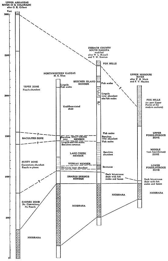
If the suggested correlation is correct, the "Tepee zone," the next higher zone of Gilbert's scheme, which he estimates to be 1,000 feet thick, corresponds to the upper half of the Pierre, which is eroded in Wallace County. It is possible, also, that the "Baculites zone" of Gilbert corresponds to the uppermost part of the Lake Creek shale of Wallace County, in which the Baculites compressus var. reesidei is very abundant. In this case the Salt Grass shale with the abundant "Lucina limestone" bodies at the base corresponds to the basal portion of the "Tepee zone," in which the "Lucina limestone" cores are very characteristic. It is possible, also, that the "Baculites zone" of Gilbert includes both the Salt Grass member and the uppermost part of the Lake Creek member of the Pierre of Wallace County.
A more precise correlation of the Wallace County Pierre with the Pierre of South Dakota appears to be possible. Although the subdivisions of the Pierre exposed along the upper Missouri river, as set forth by Meek and Hayden (see table p. 117), are too schematic and perhaps in part erroneous, the detailed description of the lithology and fossil content of the Pierre based on the study of cores obtained from a test well in northern Ziebach County, South Dakota, offers somewhat reliable grounds for correlation. It has been pointed out already that the lowermost 140 feet of the very dark gray bituminous shale, containing many bones and scales of fishes, of the Ziebach County well most probably corresponds to 155 feet of the Sharon Springs shale member. Above this dark bituminous shale ordinary unctuous shale with many streaks of bentonite was observed. The bentonite even predominates over the ordinary shale in the lower 200 feet, but is less abundant in the 160 feet of shale above. The invertebrate fossils, among which Baculites and Inoceramus are most abundant, are decidedly more numerous in the lower 200 feet. It appears probable that the lower part of the total 360 feet of bentonite shale corresponds to Weskan shale and the upper part to Lake Creek shale of Wallace County, the total thickness of these two members being 370 feet.
In the next beds above in the Ziebach County well abundant remains of Baculites are especially noted. The zone of abundant Baculites is about 60 feet thick and a little below it a bed of shale with fish bones and scales is recorded. This fish-scale bed appears to correspond to the dark shale with many fish scales a little below the base of the Salt Grass member in Wallace County. It is remarkable that between this thin bed with fish bones and scales and the lowermost 140 feet of dark-gray bituminous shale with abundant fish bones and scales no remains of fishes were recorded in the cores of the Ziebach County well. During his survey in Wallace County the writer paid special attention to the presence or absence of fish remains in the local Upper Cretaceous, and he succeeded in collecting a considerable amount of well-preserved scales of small fishes from the upper part of the Niobrara, from the Sharon Springs member of the Pierre and from the base of the Salt Grass member and a little below it, also, in Beecher Island shale, but he did not find fish scales in either the Weskan or the Lake Creek member, except at the very top of the latter member.
Considering the fact that the Pierre shale of Wallace County was studied on the outcrops, whereas the Ziebach County Pierre shale was studied in the cores of a well, the above-noted features of similarity between the corresponding portions of the sections must be considered to be very striking and more important than certain dissimilarities, most of which are apparently due to differences in the sampling of the rocks. It is quite clear, for instance, that the concretions, which appear to be so plentiful in the Pierre of Wallace County, are actually spaced so much apart that only very few of them have a chance to be met by a drill making cores of about 2 inches or less in diameter. Therefore all the important concretionary zones on which the precise subdivision of Pierre of Wallace County is based are apparently not recognizable in the cores of the well. Furthermore, it is apparent that the fossils in the cores come chiefly from the shale and few from the concretions, most of which were not met by the drill, whereas in the field work the fossils were collected largely from the concretions, the shells in the shale being usually very fragile and most of them broken into small fragments during the process of weathering of the shale. It is possibly partly due to this different origin of the fossils that the very few species of shells that were specifically identified from the lower half of the Pierre of the Ziebach County well do not appear in the identified lot of invertebrates of the Wallace County Pierre.
Another important difference between the corresponding members of the Pierre of the two localities is the apparent considerable amount of bentonite beds in the zone of Ziebach County Pierre corresponding to the Lake Creek member of Wallace County, in which streaks of bentonite were only rarely observed. The corresponding decrease of bentonite content is noticeable, also, in the Weskan shale of Wallace County as compared with the corresponding division of the Pierre in the Ziebach County well, where bentonite is the predominant rock. It is true that the name bentonite is not mentioned in the description of the shale of the Ziebach County well (Russell, 1925), but in the description of the shale "from 1,050 on down to 1,445" there are "numerous strata of light bluish-gray clay shale, that when immersed in water will swell to many times their original volume, turning to a soft plastic mud." This is the common property of the clays of the bentonite group, and therefore the writer arbitrarily refers this "clay shale" of the Ziebach County well to this rock. In the 200 feet of share of this well that apparently corresponds to the Weskan shale of Wallace County linearly all the strata" consist of the rock that swells, and the streaks of nearly white bentonite in the Weskan shale of Wallace County make only about 3 per cent of the whole volume of the shale. It was noticed, however, that at least a few more beds of ordinary gray shale in the type locality of the Lower Weskan shale, in the southwest corner of sec. 4, T. 13 S., R. 40 W., also have the property of swelling and disintegrating into fine mud when immersed in water. A remarkable tendency toward cross-bedding was noticed in the portion of the exposed shale, which is immediately below the lower thick white bentonite streak and contains several thin streaks of this rock. (See Pl. VIII A.) It is interesting that in the bentonite shale of the Ziebach County well "from 1,360-1,410 the dip is generally at a high angle, in some cases as high as 25 degrees, as indicated by the way the core breaks, by the indistinct laminations and by the inclined fossils" (Idem, p. 5). If this is the original inclination of the strata, it must have originated not in the mud but in a somewhat coarser material that was altered into clayey matter after the deposition took place. As bentonite was proved to be nothing but altered volcanic ash, it can possibly be originally inclined or crossbedded.
The writer did not try to test all the ordinary gray shale of the Wallace County Pierre in order to determine whether it has or has not the properties of bentonitic clays, and therefore he regards it as quite possible that the bentonitic clays may have a somewhat larger distribution in the local Pierre than is stated in this report (Those selected specimens of ordinary gray shale of Lower Weskan member which were tested did not show the properties of bentonite.). Only light-gray to creamy and to light-brown streaks, which differ strikingly in color from the rest of the dark-gray shale and which showed the property of swelling and almost instant disintegration in water, are recorded as beds of bentonite in this report. At any rate the Weskan shale member of the Pierre and particularly the Lower Weskan shale have a proportionately larger amount of bentonite clays than the other members of the formation, which is in accord with the general observations of the cores from the corresponding zones of Pierre in the Ziebach County well.
The Pierre subdivisions of Wallace County cannot be precisely correlated with the zones of Pierre in northeastern Colorado at present, on account of the considerable difference in the thickness of the formation in the two regions together with differences in lithologic nature and in fossil content. Several thick sandy members of the Pierre in northeastern Colorado have no lithologic equivalents in the Pierre of Wallace County, where no sand beds have ever been noted. Correlation of the members that differ in lithology could be made on the basis of fossil content, but comparatively few fossils have been collected and identified from definite horizons of the thick section of the Pierre of northeastern Colorado. The following fossils were collected in the Larimer sandstone on Fossil creek south of Fort Collins and identified by Reeside (Mather, Gilluly and Lusk, 1928, p. 89):
| Inoceramus sagensis Owen. |
| Anisomyon centrale Meek. |
| Anisomyon subovatus Meek & Hayden. |
| Baculites compressus Say. |
| Scaphites nodosus Owen. |
The fossils, though regarded as wide-ranging species, were noticed to be especially abundant in the Larimer sandstone (Idem, p. 89). According to Reeside (Reeside, 1929, p. 271), Exogyra costata Say from Fossil Ridge, near the locality on Fossil creek, which he described, came from the Rocky Ridge or the Larimer sandstone, from which also the many fossils reported by Henderson were collected (Henderson, 1907, pp. 149-152; 1908, pp. 179-192 and 1920, pp. 31-32). These fossils, according to Reeside, indicate Upper Campanian age. The following of the Fossil Ridge forms were found in the Pierre shale of Wallace County:
| Inoceramus barabini Morton. |
| Inoceramus proximus Tuomey. |
| Inoceramus vanuxemi Meek & Hayden. |
| Anisomyon centrale Meek. |
| Baculites compressus Say. |
| Acantoscaphites nodosus (Owen). |
| Discoscaphites nicolleti (Morton). |
| Placenticeras meeki (whitfieldei) Boehm. |
Although not all of these species recorded from the Fossil Ridge may strictly correspond to the species described under the same names in this report, the whole fauna, and especially the presence together of such important index fossils as Acantoscaphites nodosus and Discoscaphites nicolleti, suggest the correlation of the Larimer and Rocky Ridge sandstones with the Salt Grass and possibly upper Lake Creek shale members of Wallace County. The presence among the Fossil Ridge fauna of Inoceramus vanuxemi, which in Wallace county was not found below the Lake Creek shale member, supports this correlation, and none of the ether comparatively wide-ranging forms contradicts it.
The Larimer and Rocky Ridge sandstones of northeastern Colorado were found a little below the middle of the local Pierre (Mather, Gilluly and Lusk, 1928, pp. 90-92). and the Salt Grass and upper Lake Creek shale members of Wallace County are also about in the middle or slightly below the middle of the original pre erosional deposit of the local Pierre. If this is correct, it indicates that the thickening of the Pierre toward the west affects the lower and upper halves of the formation in about equal proportion.
It is important to point out that the areas of distribution of the Pierre in which this formation can be subdivided into members more or less strictly comparable in lithology and thickness to those into which it is here subdivided in northwestern Kansas are aligned from southeastern Colorado through the northeastern part of that state and the northwestern corner of Kansas, and farther north in southern and central South Dakota. In the western part of Nebraska, which lies in line with these comparable Pierre deposits, this formation is not exposed. The total thickness of the Pierre along this broad belt is fairly uniform, being in average about 1,500 feet with a gradual increase toward the west and a decrease toward the east. It is reasonable to conclude that these lithologically and paleontologically similar sediments, which thus constitute a belt of regular thickness and width, were deposited in similar environments of the Pierre sea and that this belt extended parallel to the general trend of the Upper Cretaceous sea. The depth and other features of this sea apparently changed in an east-west direction, which explains the great change in thickness and some changes in lithology of the Pierre west of the above-outlined belt in the piedmont region of the Rocky Mountains.
The proposed correlation of the Pierre shale members of Wallace County and adjacent area with the best known Upper Cretaceous formations and faunal zones of North America and Europe is presented in graphic form in the table opp. p. 130.
Upper Part of the Pierre Formation
The writer has had opportunity to study the fossils from the Pierre shale of the Beecher Island area, Yuma county, Colorado, collected by various members of the survey party of Mentor Etnyre in 1927-'28. He made, also, a brief personal examination of the shale and its fossil content in the field. As the shale of the Beecher Island area continues into Cheyenne county, Kansas, it is desirable to include a brief description of the rocks and fossils of this shale, which comprises the uppermost beds of the Pierre, and may be conveniently designated as the Beecher Island shale member.
Plate XVII--Rusty marl concretions with cone-in-cone structure. "Grand Canyon" style of weathering in the outer crust of the structure. Natural size. From upper zone of Salt Grass member in the NE sec. 12, T. 12 S., R. 42 W.
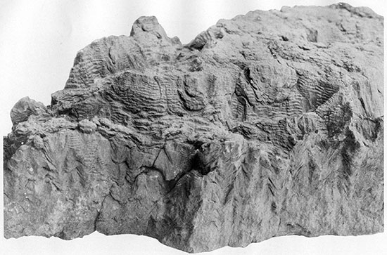
Plate XVIII-Rusty marl concretions with cone-in-cone structure. Natural size, A, B, and C from upper zone of Salt Grass shale member in the NE, sec, 12, T. 12 8., R. 42 W. A, Typical sample. B and C, Typical weathering of cone-in-cone structure. D, "Chopwood" weathering of nearly fibrous variety of cone-in-cone structure. From lower zone of Salt Grass shale member in the NE, sec, 12, T. 12 S., R. 42 W.
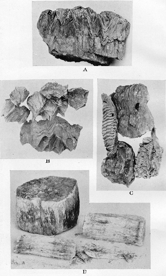
Plate XIX--Geologic sections of Salt Grass and Lake Creek members.
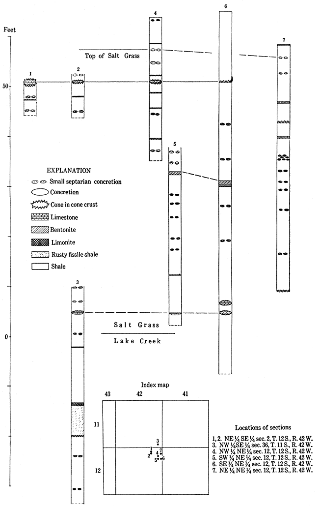
Beecher Island Shale Member
The Beecher Island shale member is chiefly light-gray shale having a distinct greenish tint on many outcrops. Thin streaks of white and brownish bentonite are found only in the lower part of the shale, where also limestone concretions, the largest 1 foot thick, are common. In the middle and. upper parts of the shale thin streaks of limonite and rusty limestone, some of the latter with cone-in-cone structure, are numerous. Irregular-shaped and comparatively small limestone bodies with Lucina, seen near the top of the section, constitute the uppermost concretionary zone of the Beecher Island member. Casts of Lucina are occasionally found, also, in the slightly calcareous shale of the same horizon, above which about 5 to 10 feet more of shale with rusty limonite streaks are exposed. The total thickness of the Beecher Island shale member reaches 100 feet. Below the lowermost concretionary zone of the member, which consists of large limestone concretions, some 1 foot thick, and a group of bentonite streaks above, a considerable thickness (more than 80 feet) of black, nearly featureless shale with practically no concretions and none of the larger invertebrate fossils is exposed in the southern part of the Beecher Island area. Fossils are abundant in nearly all concretions of the section, but the greater part of the collected material came from the lowest concretionary zone. Large, beautiful casts of Baculites grandis and less abundant casts of B. clinolobatus n. sp. came from the limestone concretions of this zone, from which also many Discoscaphites abyssinus were collected. The best specimens of the abundant and very typical Tardinacara (Pseudoptera) fibrosa and T. (P.) whitii were collected from the limonite streaks of the middle and upper parts of the section, where also Inoceramus and gastropods were chiefly found. The fauna of the Beecher Island shale member exhibits a nearly complete change compared with that of the lower half of the Pierre as seen in Wallace County; only such long-ranging forms as Lucina occidentalis, Ostrea cf. congesta and Inoceramus proximus survived into Beecher Island time. The complete list of the identified fossils from the Beecher Island shale is as follows:
| Serpula sp. |
| Lingula sp. |
| Ostrea cf. congesta Conrad. |
| Ostrea pellucida Meek and Hayden. |
| Pecten cf. venustus Morton. |
| Tardinacara (Pseudoptera) fibrosa (Meek & Hayden) Elias: |
| Tardinacara (Pseudoptera) whitii (Toepelman) Elias. |
| Inoceramus sagensis Owen. |
| Inoceramus proximus Tuomey, Meek em. |
| Volsella sp. (n. sp. ?). |
| Solemya subplicata Meek and Hayden. |
| Lucina occidentalis (Morton). |
| Lucina subundata Hall and Meek. |
| Acmae cf. parva. |
| Anisomyon sp, (n. sp. ?). |
| Cymbophora (Mactra) gracilis Meek & Hayden. |
| Melania sp. cf. wyomingensis Meek. |
| Anchura americana Evans and Shumard. |
| Fasciolaria cf. buccinoides Meek and Hayden. |
| Fasciolaria (Cryptorhytis) cf. flexicostata Meek and Hayden. |
| Valvata sp. (n. sp. ?). |
| Baculites grandis Hall and Meek. |
| Baculites meeki Elias n. sp. |
| Baculites clinolobatus Elias n. sp. |
| Discoscaphites conradi (Morton). |
| Discoscaphites conradi d. var. gulosus Morton. |
| Discoscaphites abyssinus Morton. |
| Bones of mosasaurs. |
| Scales and bones of small fishes. |
Reeside (in Mather, Gilluly and Lusk, 1928, p. 112) reports the following species from apparently the same shale member, collected "from sec. 2, T. 2 S., R. 43 W., Arikaree river, south of Wray, Colo.":
| Lucina occidentalis Morton. |
| Lunatia sp. |
| Baculites sp. |
| Discoscaphites sp. |
He reports, also, Inoceramus fibrosus Meek and Hayden (Tardinacara [Pseudoptera] fibrosa of the writer) from beds in many localities, which he refers to the same "transition zone between Fox Hills and Pierre." That the Beecher Island shale most probably represents the transition zone between these two formations is also the opinion of the writer, which was expressed by him in 1928 (Report on the Paleontology of Beecher Island area for the Etnyre Syndicate).
The well of 1928 at Beecher Island was started in the upper part of the Beecher Island shale. Examination of the cuttings from this well revealed no distinguishable foraminifera down to about 95 feet. In the samples from 95 to 110 feet, which correspond to the shale slightly below the base of the Beecher Island member, the following species were identified:
| Anomalina taylorensis Carsey. |
| Gumbelina (Textularia) globulosa Ehrenberg. |
| Rotalia cretacea Carsey. |
| Gumbelina (Textularia) globifera Reuss. |
In the Pierre shale at about the same horizon as the Beecher Island shale member, near the Phillips Petroleum Co.'s Andrews No. 1 well, which is in sec. 3, T. 22 S., R. 42 W., Yuma county, Colorado, a few fragmentary dicotyledon leaves were collected, among which the writer identified the following forms:
| Salix cf. gardneri Knowlton. |
| cf. Ficus minima Knowlton. |
| cf. Celastrus artica Heer. |
| Cinnamomum (?) sp. |
| Eucalyptus (?) sp. |
The flora, though very imperfectly preserved, appears to be nearest to the Vermejo formation assemblage of plants of Raton Mesa, Colorado, which is considered to be of upper Pierre or Fox Hills age.
| Table of Correlation of the Upper Part of the Upper Cretaceous of Kansas, with the Contemporaneous Formation of Eastern North America and Western Europe. | |||||||||||||||
|---|---|---|---|---|---|---|---|---|---|---|---|---|---|---|---|
| Standard section of Europe. | Standard section of Great Plains. | Typical section of southern and central Montana. | Typical section of northwestern Kansas. | Typical section of Gulf and Atlantic Coasts. | |||||||||||
| Age. | Faunal zones. | Formations. | Faunal zones. | Members. | Faunal zones. | Formations. | Faunal zones. | ||||||||
| Danian. | Hercoglossa danica. | Laramie. | No cephalopods Calyptraphorus. |
Wanting. | Wanting. | ||||||||||
| Maestrichtian. | Parapacilydescus neubergicus. | Montana | Fox Hills. | Discoscaphites conradi, D. iris Sphenodiscus lenticularus. |
Bearpaw | Ripley (of Tennessee). | Owl Creek. Discoscaphites iris |
Exogyra costata zone | |||||||
| Bostrychoceras polyplocum. | Transitional beds. | Montana | Beacher Island shale. | Discoscaphites conradi. D. abyssinus. |
|||||||||||
| Pierre | Discoscaphites nicolleti. Acantoscaphites nodosus. |
Judith River. | Undifferentiated. | McNairy. | |||||||||||
| Senonian | Upper Campanian. | Hoplites varians | Acantoscaphites nodosus. Scaphites plenus |
Claggett. | Salt Grass shale | Baculites pseudovatus var. A. Scaphites reesidei., S. plenus |
Coon Creek. Scaphites reesidei. |
||||||||
| Upper Lake Creek shale | Acantoscaphites nodosus s. s. Baculites corrugatus. |
Selma chalk (of Tennessee). | Exogyra cancellata subzone. | ||||||||||||
| Lower Lake Creek shale | Baculites compressss s. s. | ||||||||||||||
| Lower Campanian. | Scaphites hippocrepis. Upper limit of Scaphites s. s. in Europe. |
Scaphites hippocrepis. | Eagle. | Upper Weskan shale. | Anomia cf. subtrigonalis. | Snow Hill (of Carolinas). Taylor marl (of Texas). |
Exogyra ponderosa zone. | ||||||||
| Lower Weskan shale. | Anomia cf. subtrigonalis. | Eutaw (of Tennessee). | |||||||||||||
| Sharon Springs shale. | Small fishes. | ||||||||||||||
| Santonian. | Discocaphites aquisgranensis. | Colorado. | Niobrara. | Desmoscaphites bassleri. | Telegraph Creek. | Colorado. | Niobrara. | Orange chalk. | Hesperornis. | Austin chalk (of Texas). | Mortoniceras subzone. | ||||
| Emscherian or Coniacian. | Dicoscaphites arnaudi. Scaphites lamberti. |
Scaphites vermiformis. S. ventricosus. |
Niobrara. | Blue and white chalk. | Rudistes. | ||||||||||
| Fort Hays limestone. | Inoceramus deformis. | ||||||||||||||
| Turonian | Augoumian. | Scaphites geinitzi. | Benton. | Scaphites warreni. Prionocyclus wyomingensis. Scaphites larvaeformis. Prionotropis woolgari. |
Carlile. | Benton | Blue Hills shale. | Prionocyclus wyomingensis | Eagle Ford. | Exogyra upatoensis zone. | |||||
| Ligerian. | Mammites nodosoides. | Metoicoceras whitei. Inoceramus labiatus. |
Greenhorn. | ||||||||||||
| Graneros. | |||||||||||||||
Undifferentiated Pierre
The part of the Pierre between the Beecher Island shale member and the Salt Grass shale member was not studied by the writer. It is possibly exposed in some river valleys of Cheyenne county, Kansas, and the adjacent counties east and south. The uppermost 80 feet of this shale, which is exposed below the Beecher Island shale in the valley of Arikaree river, consists of nearly featureless darkgray to black shale with practically no concretions in it, and the lowermost 30 feet, occasionally exposed above the Salt Grass shale member in Wallace County, consists of gray shale with a few thin, rusty limonite streaks.
In the approximately corresponding part of the Pierre in the Arkansas river valley of eastern Colorado and in the southern Black Hills region the limy cores of the so-called "Tepee Buttes" are plentiful, and fossils were collected from these bodies and from the surrounding ordinary limestone concretions. In the concretions of this zone Gilbert found the following fossils, which he regards as typical for the "Tepee zone" of the Pierre:
| Inoceramus sagensis. |
| Inoceramus cripsi (probably var. barabini, as it seems to the writer). |
| "Large baculite," which is referred to Baculites compressus, but the size of" which, "2 or 3 inches in diameter" (Gilbert, 1896, opposite p. 668), oval cross-section and broad lateral undulations, as shown on Pl. LXII, suggest Baculites grandis Hall and Meek. |
| Scaphites nodosus, which looks like S. nodosus Owen and not like anyone of the many varieties of this species (Pl. LXV -2, Idem.). |
| Heteroceras nebrascense. |
| Placenticeras placenta. |
The same fossils, together with many other forms, are recorded by Henderson from the Pierre shale "above the Hygiene sandstone" north of Boulder (Henderson, 1920, p. 27; see, also, Stanton, 1888, pp. 184-187) or from about the same zone of the Pierre.
Prev Page--Formations not Exposed || Next Page--Tertiary
Kansas Geological Survey, Geology
Placed on web Nov. 6, 2014; originally published April 1, 1931.
Comments to webadmin@kgs.ku.edu
The URL for this page is http://www.kgs.ku.edu/Publications/Bulletins/18/04_strat2.html