![]()
Prev Page--Geologic Structure || Next Page--Local Subsidences
Mineral Resources
Petroleum and Natural Gas
Though neither gas nor oil has been found as yet in paying quantities in Wallace County, or in the surrounding area of Kansas, Nebraska and Colorado, the presence of commercial supplies of gas or oil in this part of the country is a possibility which fascinates both the local residents and the oil scouts from outside, who often visit this country. The big oil concerns also occasionally send their geologists to examine this part of the Great Plains, to lease this or that portion of it and to undertake various geologic explorations for oil and gas, but little drilling has yet been done. The majority of the test wells in the area have been drilled by local residents as individuals or united in small exploration companies. The location of some of the wells drilled by them was based on geologic explorations for which private geologists were employed, but the location of the majority of them seems to have been chosen on questionable geologic data or on no geologic ground at all.
Those who know how insufficient have been the geologic data upon which the great majority of these wells have been located do not regard the discouraging results of the drilling as proof that there are no commercial supplies of oil or gas in the area, and one may question whether these results really are as discouraging as they seem to be. In nearly everyone of these wells a show of oil and gas was encountered in various "sands" of the underground formations. Therefore the presence of these valuable minerals in northwestern Kansas is established. It remains to be proved, however, whether there are any natural accumulations of gas or oil that will pay for their exploitation. The largest among the local accumulations of gas so far discovered is at Beecher Island, in Yuma county, Colorado, about 50 miles northwest of Wallace County. The gas is dry and was burned safely and without odor for both lighting and heating by the exploration party in 1927-'28. The initial output of one of the old holes was 2,000,000 cubic feet per day under 450 pounds pressure. The combined steady output of one of the old wells and a new one drilled in 1928 was sufficient for running the drilling machine of the next deep well in 1929. The gas horizon of Beecher Island is at the top of Smoky Hill chalk of the Niobrara formation.
The oil-producing area in Kansas that lies nearest to Wallace County is in Russell and neighboring counties, about 100 miles east, and in 1929 oil was discovered, also, in Ness County, about 80 miles east-southeast. The main pay zone lies near the base of the Pennsylvanian and is encountered at a depth of about 3,000 feet, If the Permian and Pennsylvanian formations are of the same thickness in Wallace County as they are in Russell and Ness counties, the stratigraphic horizon corresponding to the oil-producing sand of those counties would be found in Wallace at about 4,500 feet below the surface. The Phillips Petroleum Co.'s well, 5,055 feet deep, drilled east of Beecher Island near the state line of Kansas, proved that it is easily possible to drill in the area down to this depth. There are, however, sands at much less depth in northwestern Kansas which could serve as reservoirs for commercial accumulations of oil and gas, providing enough oil or gas is present. In fact some of these higher strata are oil producers in Colorado. The oil and gas now being produced at Fort Collins, about 180 miles northwest of Wallace County, are derived from the uppermost beds of the Dakota group, and good showings of oil have been reported from the Codell sandstone, which is at the base of the Fort Hays and is regarded as a possible oil-producing bed in the vicinity of the Kansas-Colorado boundary (Mather, Gilluly & Lusk, 1928, p. 107). The recent (1930) discovery of a new possibly commercial oil and gas field north of Orchard on the Fort Morgan anticline, which is about 130 miles northwest of Wallace County, is reported in the newspapers to have been made at the top of the Dakota sandstone, at 6,666 feet from the surface. This figure appears to give a larger thickness of rocks overlying the Dakota in this area than was supposed, but there are hardly any other sands below the Dakota which could be mistaken for this easily identified formation.
Following is a list of the potential producing sands in Wallace County and their stratigraphic distance from the top of the Niobrara, the elevation of which above sea level is represented by the solid contours on the structural map of the county.
- Smoky Hill chalk. The formation is partly pervious, and gas is produced from its top beds at Beecher Island, in Colorado. A show of oil and gas at the top of the formation is recorded in the deep wells north of Goodland, Sherman County, Kansas. Gas was discovered in an unknown horizon of the formation in the old wells at Cheyenne Wells, Cheyenne county, Colorado, and in the Robidoux well of Wallace County a show of gas is recorded 260 feet above the base of the Niobrara.
- Fort Hays limestone. At Cheyenne Wells, in Colorado, the "chalk rock" at the base of the Niobrara, which apparently corresponds to the Fort Hays, is saturated with brackish water (Darton, 1905, p. 329). The top of the limestone is about 700 feet below the top of the Niobrara.
- Codell sand. This sand may be present below the Fort Hays, in the western part of Wallace County. The top of the sand is about 750 feet below the top of the Niobrara.
- Uncorrelated sand. White sand, possibly limy, lies 350 to 370 feet below the base of the Fort Hays or 1,100 to 1,120 feet below the top of the Niobrara. Strong supply of water reported in both the Wulfekuhler and Robidoux wells; show of oil and gas in the former well.
- Dakota sand. Artesian water came from the Dakota in the Wulfekuhler, Robidoux and other wells of northwestern Kansas, and a light show of oil in the Wulfekuhler well. It is the oil-producing sand of northeastern Colorado. The top of the Dakota in Wallace County is about 500 feet below the Fort Hays or 1,250 feet below the top of the Niobrara.
- Uncorrelated sand (possibly Sundance). Sand and gravel lying on the top of the red beds. Water reported in Wulfekuhler well. It is about 370 feet below the top of the Dakota or about 1,620 feet below the top of the Niobrara.
- Sands in red beds. Several beds of sand within the red beds have been found to contain water. "Oil sand showing dead oil" is recorded about 1,500 feet below the top of the red beds, or about 1,900 feet below the top of the Dakota in the Moffett and Andrews No. 1 well in Logan County, Kansas.
Though the series of sedimentary rocks penetrated by deep borings in northwestern Kansas undoubtedly includes several pervious beds, which are interbedded with impervious clayey shales and thus provide good reservoirs for the accumulation of water, oil. and gas, only a few "black" and thus presumably bituminous shales are recorded in the wells below the Niobrara. Hence a doubt may be expressed as to whether there is any local "mother rock" of petroleum in the local Cretaceous (except in the outcropping Pierre), in the Permian or in the drilled part of the Upper Pennsylvanian formation. Even if there is no such mother rock, however, the possibility of migration of oil and gas from more distant beds into the local pervious sands is not entirely excluded.
Besides the actual presence of oil and gas and the presence of reservoirs made of pervious beds inclosed between impervious rocks, there is a third requirement for an accumulation of these in commercial quantities, and this is the presence of some trap which may check the migration of oil and gas through the "sands" and thus create a "pool." Among the various kinds of traps that are known to oil geologists, closed anticlines and dome types are the most common and hence are looked for most in geologic explorations for oil. The appreciable folding of both Upper Cretaceous and Tertiary rocks in Wallace County was described and discussed in the chapter on geologic structure. At least two phases of folding, one in postCretaceous and pre-Ogallala time and the other in post-Ogallala time, have taken place in Wallace County and the surrounding area. The principal folds trend in one of two directions, and in some places the folds of the two systems cross each other. It seems as if the largest closed structural highs of the area have been formed in these intersections. One of these, and possibly the largest in Wallace County, is the Willow Creek anticline north of Weskan. Many other anticlines and domes are scattered through nearly the whole of the county. Among these are the structural highs on the flanks of which the Robidoux and Wulfekuhler wells were drilled. The writer believes that neither of these two wells is situated close to the apex of a structural high.
This statement does not mean, however, that the writer believes that commercial pools of oil, gas or both will be necessarily tapped if the apices of the most prominent closed anticlines of Wallace County are drilled, because, first of all, there might not be enough oil and gas in the area, or at least in the upper portion of the local sector of the earth's crust, to accumulate in paying quantity. The structural map of an area far from proved oil fields merely helps a proper selection of places for test wells by showing the most prominent anticlines of the area and the structurally low spots, which, according to the anticline theory of accumulation of oil and gas, are not likely to be the sites for such accumulation. The exception to this rule concerns only those very few oil fields in which there is no underground water, and where oil, taking the place of the water, accumulates in the structural lows. There is plenty of water in both the surficial and in the deeply buried sands in Wallace County and in the surrounding area, and therefore this exception to the rule is not applicable here.
It is important, furthermore, to guard against exaggerating the usefulness of a map showing the structure of the outcropping formations when a deep boring is to be made. To begin with, the folds observed in the surficial formations may gradually die out in the underlying beds. On the other hand, they may develop into greater folds farther down. The actual condition may be ascertained only after a series of deep holes has penetrated the deep-seated formations. A general hint as to the possible continuance in depth of anticlines and domes is their areal size--the larger the folds the less is the chance of their dying out in a short distance downward. It must be kept in mind, furthermore, that the axial planes of these anticlines and domes are not necessarily always vertical, and therefore their apices may be deflected in depth, which is actually the case with many. It appears to be advisable, therefore, not to drill very deep holes on the basis of the structural map alone, which shows the folding and faulting of surficial formations. Greatest attention should be given to the proper record of the rocks encountered in every new deep well in the area, because with the increase of the number of these wells accurate knowledge of the general features of the underground structure of the area will be gradually gained.
The writer has made a preliminary attempt to plot the results of the deep wells already drilled in Wallace County and the surrounding area. Though not all the desirable data concerning these wells have been collected yet, the preliminary plotting shows that the prominent group of folds that traverses Wallace County generally persists into as deep-seated beds as the Fort Hays limestone and the Dakota sandstone.
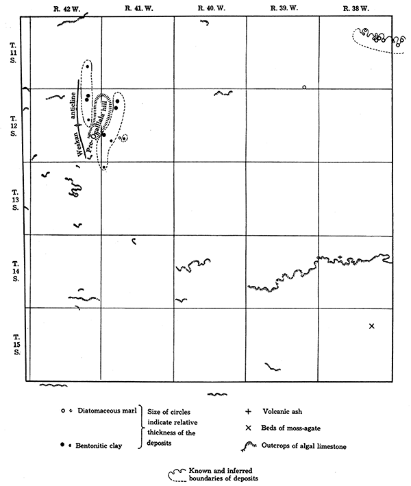
Figure 6--Map of the mineral resources of Ogallala, Wallace County.
Clays
The clays of Wallace County belong to the Pierre and to the Ogallala. Loess, also, can be considered a clay to some extent, but it has properties peculiar to it, and is not used in the ceramic industry.
The whole thickness of the Pierre is made of clayey shale, but the commercial value of most of this shale is low. The systematic and thorough examination of the shale of the same formation in the neighboring area of eastern Colorado gave results that are generally applicable to the clayey shale of the Wallace County Pierre and is quoted here (Butler, 1914, pp. 115-116).
"The Pierre is essentially a formation of low-grade brick shales. Almost all the shales will fuse below cone 5, and over 60 per cent will burn red; while, of the remainder, about 90 per cent will burn pink. Over 40 per cent of the samples tested, however, are so deficient in tensile strength that they are unadapted to the manufacture of stiff-mud brick or earthenware. Twenty per cent of all the beds tested are probably worthless, and the same proportion might be used in making other products besides brick. The worthless beds sampled all lie near the top of the formation, except one case where a lower shale has been metamorphosed or changed by the intrusion of a mass of igneous rock. Fifteen per cent of the samples vitrified fairly well, but none gave much reason to suppose that a good paving brick could be made from them."
"While much of the formation will make good red brick, the product is not usually so attractive as that obtained from the Graneros and Carlile shales, and the absorption is apt to be rather high."
The field examination of the Pierre shale of the county shows a variable proportion of unevenly distributed calcium carbonate, calcium sulphate (gypsum) and sulphate, carbonate, and hydroxides of iron, all of which have a more or less harmful influence on the usefulness of the clays. The flaky black shale of the Sharon Springs and Lake Creek members of the formation is the poorest kind of shale for making bricks. The best shale, some of which is nearly free from the above-listed harmful impurities, is the gray clayey shale with interbedded thin bentonite streaks, which belongs to the Lower Weskan member of the Pierre. The best outcrop of this clayey shale is in the SW, sec. 4, T. 13 S., R. 40 W., on the south side of Goose creek, about four miles northwest of Sharon Springs; it outcrops, also, in the SW, sec. 6, SW, sec. 8, and in other places in the same township. The outcrop in SW, sec. 31, T. 12 S., R. 38 W., about three and one-half miles north of Wallace, also seems to have few damaging impurities.
The bentonitic clays of the Ogallala formation are more interesting from a commercial standpoint, but their usefulness and value can be established only after research work or special commercial tests. Only a few of these Ogallala clays can be used for making bricks, because many of them contain calcium carbonate and calcium sulphate. On the other hand, they may possibly be valuable for oil refining.
It is recommended to those who are interested in the production of bentonite that they "should make a careful investigation of the commercial possibilities of the deposit in question before investing heavily. Such a study should include the possibility of marketing the product, the specifications demanded, the price obtainable, the cost of mining, treating, and shipping to market, the size of the deposit and the nature of the crude bentonite. Most consumers desire a homogeneous product that will remain uniform over a period of years," which implies that a commercial deposit of bentonite must be of considerable size and fairly homogeneous (Davis and Vacber, 1928, p. 29).
The Ogallala bentonite beds (Pls. XXX A, XXX B and XXX C) of Wallace County are fairly thick and' range from 6 to 30 feet of a uniform grade of clay. Laterally these beds may not be very extensive, . but some that are exposed could be traced in the field over several hundred yards. Perhaps the largest deposit is in the SW, sec. 19, T. 12 S., R. 41 W. A bed of pale-green clay in places 30 feet thick and of an apparently uniform texture is here exposed. The exposure extends for about 150 yards in a west-east direction and lies at the head of a wide, basin-like canyon, which is a southern tributary to Collins draw. The overburden consists of Pleistocene gravel and loess and is in places 20 feet thick. In the Roy Johnston canyon two beds of bentonitic clay, one 6 feet and the other 7 feet thick, are exposed. The later, which is the upper bed of the two, is exposed on several branches of the repeatedly forking Johnston canyon. The bentonite of this canyon has a considerable overburden (40 feet or more) and therefore cannot be stripped and must be mined. The lower bed of bentonitic clay at the mouth of the canyon, one mile west of Woodhouse ranch, reaches 20 feet in thickness and is exposed for 300 yards or more. Only part of the bentonite of this exposure can be stripped.
In all of these beds bentonitic clays contain efflorescences and nodules of calcium carbonate and veins of gypsum (the latter in the deposit in the SW sec. 19, T. 12 S., R. 41 W.). However, taking into account the fact that most crude bentonites contain a considerable amount of impurities of this and other sorts, which must be removed by expensive washing, the Wallace County Ogallala bentonites do not seem to be exceptionally impure. All in all they appear to be uniform enough and extensive enough for a commercial prospecting and testing.
Bentonite is used in refining crude oils and fats, as a binder and filler for various products and in many other ways. For particulars in regard to bentonite and its commercial uses see Davis and Vacher, Bentonite, its property, mining, preparation and utilization: Technical paper 438, Bureau of Mines, 1928; also Bentonite, properties, sources, geology, production: Bulletin 107, Silica Products Co., Kansas City, Mo., 1930.
The "yellow dirt" or loess of Wallace County (Pls. XX A, XXXV A and XXXV B), which is in all ways comparable to the loess of China (see chapter on loess), is a wonderfully fertile subsoil of the county and is a good material for holding water in dams and irrigation ditches, but can hardly be used for commercial purposes as clay, having too high a percentage of calcium carbonate.
Volcanic Ash
The known volcanic ash beds of Wallace County are not extensive. The writer found only one bed of bluish-white volcanic ash near the base of the Ogallala in the SE, sec. 8, T. 14 S., R. 38 W. The bed is only 2 feet thick and has a very large overburden.
Some localities of probably Pleistocene ash in Wallace County have been recorded by M. Etnyre (Landes, 1928, p. 46).
Gravel and Sand
Both gravel and sand are very common in Wallace County. There is a thick and persistent bed of loose gravel in the upper part of the Ogallala. This bed in places is 20 feet thick and is exposed extensively on the north and south sides of Willow creek and on the north side of the south fork of Smoky Hill river, north of Weskan. Owing to its high position in the Ogallala section, this gravel is exposed high on the flanks of the river valleys. Good exposures of probably the same bed of gravel are on the south side of the north fork of Smoky Hill river along the north county line, in T. 11 S., R. 42 W. Another locality is in the SW, sec. 35, T. 11 S., R. 40 W. This gravel bed of Ogallala pinches. out or becomes thinner and cemented in the southeastern part of Wallace County.
A widespread gravel bed is that of the Pleistocene at the base of the loess formation, but the thickness of this bed varies greatly. Good outcrops of this gravel, some as much as 30 feet thick, have been noted in the following localities:
| Northeast corner of sec. 4, T. 11 S., R. 28 W. Low on the valley on the north side of north fork of Smoky Hill river; 30 feet thick. This gravel may also belong to alluvium of the river. |
| Sec. 22, T. 12 S., R. 40 W., near the head of the draw; 10 to 20 feet thick. NE, sec. 6, and SE, sec. 13, T. 13 S., R. 41 W., thickness unknown. |
| West side of sec. 1, T. 13 S., R. 39 W. Two prominent knobs on the hill. Probably 10 to 15 feet thick. Also in other places. |
The alluvial sands (Pl. XXXV C), which grade into gravel in places, fill up the river valleys wherever Ogallala is extensively exposed. They are distributed through the valley of the south fork of Smoky Hill river, in western Wallace County, and gradually become thinner toward the east, where the river loess becomes predominant in the valley.
On the upper part of Goose creek the sands are heavy and they thin gradually toward the east, and then toward the, south along the valley.
There is plenty of sand on the north fork of Smoky Hill river in the northeast part of T. 11 S., R. 38 W., and especially in the valley of its southern tributary in secs. 23 and 24, T. 11 S., R. 38 W. The sand is present in the valleys of nearly all other creeks and draws of the county on the slopes of which Ogallala is exposed. At present the sands and gravels of Wallace County are used but little.
The sands of the south fork of Smoky Hill river are dug at the main roads north and northwest of Weskan in secs. 23 and 18, T. 13 S., R. 42 W. Gravel for ballasting railroad tracks is dug in a small pit northeast of Weskan, in the NE, sec. 35, T. 13 S., R. 42 W.
Stone
Building Stone
The massive chalk that forms prominent cliffs between softer chalky beds of the Niobrara has been used as building material, but the chief exposures of this kind of chalk are in Logan County east of Wallace. The massive chalk is very uniform in texture, is of pleasant creamy to orange color and is so soft that it can be sawed easily into almost any size blocks. The walls at Fort Wallace, now in restored condition, are built of the sawed blocks of chalk, and the same material was used for the memorial monument (see Pl. XXXIX A). In spite of its softness the chalk resists weathering strongly. Even the finest details of the carved ornaments on the monument at Fort Wallace have not been obliterated, and the monument was erected sixty-three years ago.
Unfortunately the buildings made of sawed chalk blocks are too rigid to resist exceptionally severe tornadoes, but in this respect they are no more dangerous than brick buildings. To make these rigid constructions as much tornado-proof as possible the bricks or blocks must be tied together firmly. The same rules for safe construction that are followed in zones of earthquakes are equally applicable to the areas visited by tornadoes. A few houses and barns in the Smoky Hill river valley southeast of Wallace, which were built of sawed blocks of chalk, were apparently wrecked by a fierce blow of wind and have not been restored.
Another building stone that is sometimes used by the residents of Wallace County is the hard limestone of the Ogallala formation. The three beds of limestone that have been used for this purpose are the white limestone at the top of the diatomaceous marl, exposed near the Marshall ranch, on the south side of the north fork of Smoky Hill river, in T. 11 S., R. 38 W.; the white limestone grading into chert on the top of the diatomaceous marl, exposed east of the Collins ranch, in sec. 29, T. 12 S., R. 41 W.; and the pink concentrically banded limestone at the top of the Ogallala. Plate XXXIX B shows a small quarry opened in the last-mentioned limestone in sec. 4, T. 11 S., R. 42 W, All these limestones are in beds from 1 to 4 feet thick and as a rule break into irregular-shaped slabs and are altogether much inferior to Niobrara chalk as building stones. The limestone of the Marshall ranch was used for the foundation of the old Robidoux ranch house, and out of the Collins ranch limestone the whole house, now abandoned, in sec. 22, T. 12 S., R. 41 W., was built.
Ornamental Stones
Among the material of the gravels of the Ogallala and the Pleistocene there are occasionally found well-worn pebbles and some crystals of transparent and colorless or smoky rock crystal. Fairly good gems have been cut out of some of these pebbles by local citizens. Fragments of green and red jasper, of agate and of silicified wood are more common, but less attractive, stones among the material of the conglomerates.
The pink concentrically banded compact limestone at the top of the Ogallala takes polish nicely (Pl. XXI B) and in a nontechnical sense can be called marble. It is a beautiful stone but can be used only for small ornaments, because it occurs broken into slabs and blocks of moderate to small size.
Moss agate is another ornamental stone of Wallace County. The first state geologist of Kansas, B. F. Mudge, discovered and described this stone from a locality in the Tertiary (Ogallala) south of Fort Wallace [Mudge, 1874 (reprinted in 1896), p, 15]. The writer examined a bed of variously colored semitransparent moss agate in the Ogallala exposure on the east side of the canyon in the NW sec. 11, T. 15 S., R. 38 W., which is possibly the locality referred to by Mudge. The stone takes grinding with comparative ease and without getting cracked. It takes, also, a good polish. The bed to which the moss agate belongs is about 2 feet thick and is made of spongy siliceous matter with irregular bands of only slightly porous to solid, opallike, milk to nearly transparent material with small black, irregular dendrites in it. The cliff of Ogallala in which the bed of moss agate was observed consists of the following beds from the top down:
| Feet | ||
|---|---|---|
| 5. | White spongy limestone, hard, with irregular bands of milky chert | 3 |
| 4. | Same limestone, softer, no chert | 5 |
| 3. | Hard spongy and cavernous chert with moss agate | 2 |
| 2. | Calcareous grit, soft, becoming harder toward the base | 3.5 |
| 1. | Grit, medium hard with larger pebbles | 5.5 |
Diatomaceous Marl
Three areas of diatomaceous marl in Wallace County have been discovered and studied by the writer. The largest one, on the Marshall ranch on the north fork of Smoky Hill river, has been called "chalk rock" by local residents and also has been supposed to be volcanish ash, as similar white rock with abrasive or polishing qualities is widely distributed in western Kansas. A microscopic examination under high magnification (300 times or more) discloses the fact that this rock in Wallace County consists almost entirely of the siliceous tests of fresh-water diatoms and of flaky calcium carbonate.
Constitution of the Marl
Preliminary quantitative analysis of an average sample, prepared from the upper 5 feet, which is about half of the bed at the Marshall ranch, showed that dry rock with moisture expelled at about 105° C. consists of about 81 per cent of matter soluble in hydrochloric acid. This is chiefly if not entirely fine, flaky calcium carbonate. About 90 to 95 per cent of the insoluble part consists of siliceous tests of diatoms and siliceous spicules of sponges. Fine to medium grained quartz sand with a slight mixture of feldspar constitutes the balance of the insoluble part. Owing to the construction of the box-shaped empty tests of diatoms the percentage of the volume occupied by these tests is much greater than the percentage by weight. Roughly estimated about one-half of the rock by volume is made up of diatoms.
Possible Uses
The large content of calcium carbonate makes it appropriate to call the rock a diatomaceous marl instead of a diatomaceous earth. Another reason for this term for the Marshall ranch rock lies in the difference between the practical uses that can possibly be made of diatomaceous marl and those of the pure or nearly pure varieties of diatomaceous earth obtained from southern California and other localities.
The diatomaceous earth, which consists chiefly or entirely of the tests of diatoms, is a highly porous rock and is used now chiefly as a sound and heat insulator in building construction, as a filter for purifying drinking water and for other uses in which high porosity, neutrality to acids, or the hardness or sharpness of the minute tests of diatoms composing it are of advantage. The rock from the Marshall ranch might be regarded as a diatomaceous earth mixed with a large quantity of flaky calcareous matter. It is softer and much less porous than regular diatomaceous earth and far from neutral to acids. Thus, though the diatomaceous marl of Wallace County can probably be used for some purposes for which diatomaceous earth is now employed (for instance, as sound and heat insulators, as an abrasive, etc.), it is obviously an inferior material compared with the purer grades of the latter. On the other hand, the intimate mixture of diatomaceous tests with calcium carbonate appears to have peculiar useful properties of its own, which will decide its place and its value among other mineral resources of this country.
It was noticed that if the amount of silica, and to a much less extent alumina and some other impurities, in some limestones of Europe is increased to about 12 per cent or more, lime manufactured from these rocks begins to acquire the property known as "hydraulicity," that is, it can harden or "set" under water. The natural cement made of these limestones is known as "hydraulic lime." Hydraulic lime is white and in this and some other important respects differs from the ordinary yellow or brown natural cements of the "Roman cement" type, which contain a much smaller amount of calcium carbonate and in which alumina and iron constitute a considerable part. A typical natural cement of this latter kind is manufactured at Fort Scott, Kan. The limestone from which the Fort Scott hydraulic cement is made contains: Silica, 18.09 per cent; alumina, 3.44 per cent; iron oxide, 4.27 per cent; lime, 35.32 per cent; and magnesia, 4.62 per cent (average analysis, Eckel, 1928). The most famous and typical hydraulic lime is that known as Le Teil or La Farge, made from a limestone found in Ardeche, France. This limestone consists of calcium carbonate very intimately intermixed with finely divided silica. It contains very little alumina and oxide of iron, which are the constituents generally necessary to bring about the union of silica and lime to form a cement, but in spite of this the silica is so finely divided and so well distributed that it unites readily with the lime when the limestone is burned at a sufficiently high temperature. When subsequently a little but proper quantity of water is poured in, it slakes or disintegrates into fine powder and thus does not need to be ground, which is an unavoidable expense in the manufacture of ordinary cements of both the Portland and the natural hydraulic cement (Roman) types.
As has been said, the Wallace County diatomaceous marl is a chalky substance with about 18 to 19 per cent of silica. It is composed chiefly of very fine tests of diatoms intimately mixed with flaky calcium carbonate. There may be a trace of alumina. It remains to be seen if the two most important components of the Marshall ranch rock, calcium carbonate and silica, are fine enough and mixed intimately enough to produce a good natural hydraulic lime after being burned.
One hundred pounds of the diatomaceous marl from the Marshall ranch has been shipped by the Kansas Geological Survey to the United States Bureau of Standards, which has agreed to make tests in order to find out if the rock can be used for manufacture of hydraulic lime. The experiments of the Bureau of Standards are not completed, but preliminary study shows "from the work up to date it would appear that this material can be burned so as to produce a lime having hydraulic properties (Letter of Bureau of Standards, Dec. 29, 1930).
Hydraulic lime has some properties that make it different from Portland cement and from natural hydraulic cements. It sets more slowly than these cements, but ultimately becomes as strong as Portland cement. The slow setting is an advantage for some special purposes, as for foundations and abutments where settling may occur. The structure is free to take its permanent position before the lime sets, and cracks are thus avoided. It is used, for instance, in place of Portland cement as grouting outside the cast-iron tubes used for lining tunnels made by the shield system. Being low in iron and soluble salts, hydraulic lime is light-colored and does not stain masonry, having thus a fair market for architectural uses in cities, especially in the east and southeast parts of the United States, where this cement is now imported annually (Eckel, 1928, p. 178).
The available American and French literature lacks precise description of the lithologic characters of the Le Teil marl, but the reported chemical constitution is almost identical with that of the Marshall ranch diatomaceous marl. The following are analyses of some European limestones from which hydraulic lime is manufactured (Idem, P. 180).
| Le Teil, France | Senonches, France |
Hansbergen, Germany |
||
|---|---|---|---|---|
| Silica (SiO2) | 12.40 | 16.80 | 17.00 | 11.03 |
| Alumina (Al2O3) | .60 | .81 | 1.00 | 3.75 |
| Iron oxide (Fe2O3) | .50 | trace | * | 5.07 |
| Lime (CaO) | 47.49 | 45.50 | 44.80 | 43.02 |
| Magnesia (MgO) | * | * | .71 | 1.34 |
| Carbon dioxide (CO2) | 37.31 | 35.67 | 35.99 | 35.27 |
| * Not determined. | ||||
The Marshall ranch diatomaceous marl is a fresh-water deposit of lower Pliocene age, whereas the siliceous marl of Le Teil constitutes the Criocera marls of the marine Lower Neocomian of the Cretaceous. The source of the finely distributed silica in the beds from Le Teil is unknown. The possibility of the presence of diatoms irr these rocks is not excluded, for the tests of these organisms are known in marine Cretaceous limestones of European Russia and of California.
Description of the Marshall Ranch Deposit
The Marshall ranch diatomaceous marl (Pls. XXXI A, XXXVIIA, XXXVIII A, XXXVIII B and XXXVIII C) outcrops on the south side of the north fork of Smoky Hill river in secs. 10, 11 and 12, T. 11 S., R. 38 W., in Wallace County, and extends into sec. 7, T. 11 S., R. 37 W., in Logan County. The total length of the exposures, interrupted in places by loess, is slightly more than three miles. The thickness of the bed ranges from 2 or 3 feet, in the middle of section 11, to 11 feet in the eastern part of this section. The average thickness from here to the easternmost exposure in Logan County is about 7 feet. In the west half of section 11 the diatomaceous marl is more limy and is hard, but in the NW sec. 10, it is somewhat softer. On the top of the bed there is nearly always a thin hard ledge of white limestone, usually full of small cavities representing molds of freshwater gastropods. This limestone is a few inches to a foot thick. At the base of the diatomaceous marl there is generally a light-gray clay (Pl. XXXVIII C) with some mixture of calcareous matter and diatoms, but locally there is greenish sand in place of clay at the base. A number of mammalian and other bones have been found in this sand.
The constitution of the diatomaceous marl is fairly uniform throughout. It is everywhere a snow-white chalky rock, light and very fragile. However, it resists weathering, and together with the capping thin limestone forms low cliffs and benches on the southern slope of Smoky Hill river valley. In a few places erosion has formed separate cliffs of the diatomaceous marl, which are scattered on the smooth, gently descending slope of the valley. The rock is usually massive and is cut by widely spaced vertical joints into large blocks (Pl. XXXVIII B). However, it has also a distinct horizontal stratification and can be broken with comparative ease along the closely spaced bedding planes.
The Ogallala formation, to which the diatomaceous marl bed belongs, is slightly folded in this area (Pl. XXXVII A) and consequently the bed is not at the same elevation at all places along the outcrop. It is about 60 feet above the level of Smoky Hill river at the west end of the exposure, and ranges from 80 to 120 feet above it in the middle and eastern parts, whereas the river drops about 50 feet in the interval.
The overburden above the diatomaceous marl consists of the thin hard limestone and in some places of nearly 15 feet of Ogallala grit, slightly cemented with calcium carbonate. Above this lie gravel and loess of the Pleistocene. The specific gravity of airdry rock is about 1.53, which is approximately three times as much as that of pure diatomaceous earth from California.
The supply of diatomaceous marl at the Marshall ranch locality can be roughly estimated in the following way~ The length of the exposures of the marl with average thickness of 6 feet is about 2Y2 miles. The zigzag arrangement of exposures along this length makes it possible to observe that the thickness of the bed does not decrease appreciably within at least one-eighth of a mile at right angles to the general trend of the outcrop. The overburden ranges from 0 to 30 feet in thickness. Considering that this strip of diatomaceous marl, which is 2 1/2 miles by one-eighth of a mile in area, is decreased by about one-half by the many canyons and gulches in which the rock is eroded away, the total volume of the remaining diatomaceous marl on the divides between the small canyons is about 26,136,000 cubic feet. As the diatomaceous marl weighs about 85 pounds to a cubic foot, this volume corresponds to more than 1,000,000 tons. This estimate does not pretend to be exact, but gives the correct idea as to the amount of diatomaceous marl which could be stripped where overburden does not exceed 30 feet.
Other Deposits of Diatomaceous Marl
Two other outcrops of diatomaceous marl in Wallace County have been studied. One that was shown to the writer by James T. Madigan is in the SE SE, sec. 35, T. 11 S., R. 39 W., at the very head of one of the many draws on the south side of Lake creek. The soft snow-white diatomaceous marl, with apparently the same qualities as possessed by that of the Marshall ranch, makes here a small, inconspicuous outcrop. The small size of the outcrop is probably due to the absence of the hard limestone at the top of the bed. The thickness of the outcropping rock is about 3 or 4 feet, but neither the base nor the top is visible. A few feet above the outcrop loess can be seen in the bluffs at the head of the canyon, and below and somewhat down the canyon there are a few outcrops of Ogallala grit.
The third locality of diatomaceous marl and the one in which the diatoms were first recognized by the writer in 1928, is in the northeast corner of the NW~, sec. 29, T. 12 S., R. 41 W., about half a mile east of the Collins ranch. The diatomaceous marl of this locality is of somewhat different color and texture from the other deposits. It is light gray and is softer than the rock from Marshall ranch. There is probably less calcium carbonate and more diatoms in this rock, and it contains an admixture of clayey material. It is slightly harder at the top and is capped by limestone partly silicified into compact, tough chert. The bed is 4 feet thick and is underlain by greenish-gray clay. The lateral extent of the bed seems to be insignificant.
Soft light-colored rocks in which diatoms constitute a considerable part are known in southwestern and western Nebraska and in Beaver County, Oklahoma, from which locality they probably extend into Meade and Seward counties of southwestern Kansas. The diatomaceous deposits of Nebraska belong chiefly to the Pleistocene (Barbour, Eleanore, 1910, pp. 3-4), but at Agate, Sioux county, is a deposit considered by H. J. Cook to belong to the lower Harrison formation of lower Miocene age (Personal communication of H. J. Cook to the writer, March 18, 1930).
The Beaver County, Oklahoma, diatomaceous marl was explored by Cragin, who calls it "chalk marl" and refers it to the "Loup Fork Tertiary" on the strength of some mammalian remains that he collected (Cragin, 1891, pp. 29-32). Cragin cites the identification of several species of diatoms in the marl by Francis Wolle, to whom he sent a sample for microscopic examination. The same locality was visited in 1893 by Case, who collected there a great many beautifully preserved impressions of dicotyledonous leaves and other fossils, which are deposited at the University of Kansas (Case, 1894, pp. 143-147). A much smaller collection of leaves, also gathered by Case, was studied by E. W. Berry, who concludes that they belong to the upper Miocene, but possibly also to the lower Pliocene (Berry, 1918, pp. 627-686; also in Gould & Lonsdale, 1926, pp. 84-39).
According to Case "the chalk appears in limited outcrops for about thirty miles along both sides of the Beaver, at a distance of three or four miles from the immediate river valley" between Beaver City and Alpine, the outcrops being "capped with flint." The largest bed of chalk "is that on the south bank of the Beaver, about four miles up a small tributary called 'Gypsum creek.'" [Case, 1894, p. 145] Neither Case nor Cragin measured the exact thickness of the bed, but one may infer from their descriptions that the bed must be more than 5 feet thick.
Another locality of diatomaceous marl in Beaver County, closer to the Kansas boundary line, is described by Buttram in the east central part of the NW~, sec. 4, T. 5 N., R. 27 W. This occurs in a bed 12 feet thick and contains: SiO2, 10.68 per cent; Fe2O3-Al2O3, 23.49 per cent; and CaO, 35.55 per cent (Buttram, 1914, p. 40). The material contains abundant diatoms, which are believed to account for practically all the silica in the rock.
Adams has briefly described (Adams, 1902, pp. 801-308) "a soft chalky limestone about 10 feet in thickness," which is exposed on both sides of the Cimarron river in Seward County, Kansas. He compared it with the beds in Beaver County, Oklahoma, described by Cragin and Case. It is thus probable that the Tertiary diatomaceous marls of Oklahoma extend into southwestern Kansas. Whether these beds belong to the Ogallala formation in a restricted sense and whether they can be equivalents of the Marshall ranch diatomaceous marl remains to be determined. Plenty of fossils from the Beaver County locality have been collected and recorded by Cragin and Case, but except the few dicotyledonous leaves described by Berry none have been described.
Underground Water
Except on a few stretches of land where little water is obtainable from shallow wells, the residents of Wallace County have a good supply of wholesome water for domestic use and for cattle. This is largely a "sheet water" from sands and gravels of Ogallala, especially from the base of this formation. The underlying Pierre shale and, in the southeastern part of the county, the underlying shaly chalk of the Cretaceous constitute the impervious floor which supports the sheet water at the base of the Ogallala. The same Cretaceous formations constitute the impervious bottom of the valleys, upon which rest the alluvial sands and gravels saturated with water of "underflow." This "underflow water" is usually good and plentiful. The valleys of Rose creek and Eagle Tail creek are especially noted for their rich supply of water, even in years of drought that occasionally strike western Kansas. The water of these creeks is supplied by the large number of springs flowing from the base of the Ogallala, which builds the nearly horizontal high plateau of the southern part of the county. Eagle Tail creek and especially Rose creek developed deep and extensive basins in this southern plateau. It has been noticed since the explorations of water resources of the High Plains by Robert Hay that wherever the sandy Ogallala formation of the divides is poorly developed or not present at all, and the mantle of loess rests directly on the Cretaceous, there is but little or no sheet water in the irregular bodies of sand and gravel at the base of the loess. Loess, though a porous rock and usually saturated with water, acts as an impervious barrier and is successfully used for water storage in irrigation dams and ditches. This quality of loess is due to its having an extremely fine capillary porosity, so that it absorbs greedily a considerable quantity of moisture but does not part with it easily and does not let it through, thus checking its migration.
The areas of wide development of Ogallala, with little loess over it or with the overlying loess cut by a net of ravines or by groups of nearly circular depressions, are areas of the greatest imbibition of atmospheric precipitation in the High Plains.
The deep Robidoux and Wulfekuhler wells proved that the Dakota sandstone, the top of which is from 1,100 to 2,000 feet below the surface of Wallace County, yields a considerable supply of artesian water, which is, however, much inferior to the sheet and underflow water for drinking. In the Wulfekuhler well the artesian : water of the Dakota was capped at 1,437 feet, and the water rose 700 feet in the hole. Another water sand, also within the Dakota, was reached at 1,511 feet, and the hole became filled with water.
In the following list the available information in regard to the supply of sheet water of the divides and the underflow of the valleys is given for every township in the county.
| Water resources of the townships |
|---|
| T. 11 S., R. 42 W. Sheet water within Ogallala and at the base of it; valley water along larger streams; 160 feet to water in the NW, sec. 8; 120 feet to water in the SE, sec. 4; 41 to 58 feet to water in section 24. |
| T. 11 S., R. 41 W. Sheet water within Ogallala and at the base of it; valley water along larger streams. |
| T. 11 S., R. 40 W. Sheet water within Ogallala and at the base of it; valley water along larger streams; 68 to 76 feet to water in the NE, sec. 2; 125 feet to water in section 14; 60 feet to water in the east part of section 22. Dirt dam is built across the draw in the NW, sec. 27, to hold water for irrigation. |
| T. 11 S., R. 39 W. Chiefly valley water along Lake creek and along its larger left tributaries. Less water in the north. Little or no water on the right or south side of Lake creek. |
| T. 11 S., R. 38 W. Sheet water at the base of Ogallala; valley water along larger streams; 180 feet to water in the NW, sec. 14; 45 feet to water in the SE, sec. 13. |
| T. 12 S., R. 42 W. Sheet water chiefly at the base of the Ogallala; valley water along larger streams; i08 to 130 feet to water in section 10; 90 feet to water in the east part section 18; 140 feet to water in the NE, sec. 19; 160 feet to water in the east part of section 30. No water encountered though "black shale" was struck at depth over 100 feet. Large depression in sections 9 and 16, east of abandoned schoolhouse, always wet in the bottom. Little or no sheet water in the central part of the township, which is on the line of Weskan meridianal structural ridge. |
| T. 12 S., R. 41 W. Chiefly valley water along larger streams. Little sheet water in west central and no sheet water in east central part of the township where Ogallala thins out and loess overlies Pierre shale directly; 24 feet to water in Collins draw in section 22. |
| T. 12 S., R. 40 W. Sheet water in northern half of the township and valley water along larger streams. Less or no sheet water in south and southeast parts where Ogallala thins out and loess overlies Pierre shale directly. Dip circular basin, "Old Maid's pool," in the northeast corner of section 30 never dries up; 17 feet to water in Goose creek valley in the southeast corner of section 32. |
| T. 12 S., R. 39 W. Little or no sheet water in the northern half of the township. Valley water along larger streams. All old basins and cave-ins in northeastern part of the township are dry except one recent cave-in in section 1, which cuts through the channel of the intermittent stream and is full of water. |
| T. 12 S., R. 38 W. Chiefly valley water along larger streams. No or very little sheet water in central, southern and southeastern parts of the township where loess overlies the Pierre shale directly with only insignificant local remnants of Ogallala between. However, the large basins in the southeastern part of the township are wet on the bottom. |
| T. 13 S., R. 42 W. Plenty of sheet water within Ogallala and at the base of it and valley water in Smoky Hill river and in Willow creek; 80 feet to water in the northeast corner of section 3; 60 feet to water in the NW, section 10; 10 feet to water in the valley of Smoky Hill river in section 24; 157 feet to water in section 28 and 159 feet in section 34; 40 feet to water in section 32. The water in the last place is considered hard. Geologic study of the area indicates that the water comes from a sand in the upper part of the Ogallala formation. The hardness of the water is most probably due to calcium carbonate dissolved from Ogallala sediments, which are especially rich with lime near the top of the formation. |
| T. 13 S., R. 41 W. Sheet water at the base of the Ogallala. Valley water along larger streams; 50 feet to water in section 24; 16 to 30 feet to water in the north of section 34. |
| T. 13 S., R. 40 W. Mostly valley water along the main streams. Very little water in the central part of the township north of Sharon Springs, and little or no sheet water in the north, northeast, and southwest parts, where loess overlies the Pierre shale directly; 27 to 39 feet to water in the southern part of section 27 and in the northern part of section 34, the water being supplied by the underground stream of the intermittent Eagle Tail creek; 20 feet to water in Smoky Hill river valley in the NE, sec. 24. |
| T. 13 S., R. 39 W. Little sheet water, the Ogallala being absent from most parts and loess overlying the Pierre shale directly. Valley water along the larger streams; 40 feet to water in Eagle creek valley in the NW, sec. 30; 16 feet to water in Smoky Hill river valley in the west of section 26. |
| T. 13 S., R. 38 W. Chiefly valley water along the larger streams. |
| T. 14 S., R. 42 W. Sheet water within and at the base of the Ogallala. Valley water along North Ladder creek. Probably little water southwest of Weskan, on the line of Weskan structural ridge; 143 feet to water in the NE, sec. 3. |
| T. 14 S., R. 41 W. Sheet water within Ogallala and at the base of it. Valley water along the larger streams; 85 feet to water in the SE, sec. 15; 70 feet to water in the NE, sec. 22; 115 feet to water in the NW, sec. 36. |
| T. 14 S., R. 40 W. Sheet water within Ogallala and at the base of it; little sheet water in the northwest corner of the township, where loess overlies the Pierre shale directly. Valley water along the larger streams; 120 feet to water in the SE, sec. 18; 170 feet to water in the NE, sec. 17; 135 feet to water in the SW, sec. 16, and in the NE, sec. 12. |
| T. 14 S., R. 39 W. Sheet water within and at the base of the Ogallala. Valley water along larger streams except in the large draw in the northeast corner of the township, which has but little underground water. |
| T. 14 S., R. 38 W. Sheet water within and at the base of the Ogallala in the middle and southern parts of the township. Valley water in larger streams in the south. Little water and most of it not fit to drink in the many canyons on the slope of Smoky Hill river valley. Dirt dam is built in the canyon in the SE, sec. 1, which holds water for irrigation. |
| T. 15 S., R. 42 W. Sheet water at the base of the Ogallala and valley water along the larger streams. No water in the central part of the township (area shaded on the structural map) probably because the area is on the middle of an underground hill projecting into the Ogallala; 150 feet to water in the NW, sec. 2, and 163 feet to water in the west part of section 2; 150 feet to water in the NE, sec. 1; 200 feet to water in the SW, sec. 36; 200 feet to water in the SW, sec. 7. |
| T. 15 S., R. 41 W.; T. 15 S., R. 40 W.; T. 15 S., R. 39 W.; and T. 15 S. R. 38 W. Sheet water in Ogallala and valley water along the larger streams; 150 feet to water in the NW, sec. 4, T. 15 S., R. 41 W. |
Prev Page--Geologic Structure || Next Page--Local Subsidences
Kansas Geological Survey, Geology
Placed on web Nov. 6, 2014; originally published April 1, 1931.
Comments to webadmin@kgs.ku.edu
The URL for this page is http://www.kgs.ku.edu/Publications/Bulletins/18/06_mine.html