![]()
Prev Page--Mineral Resources || Next Page--Bibliography
Local Subsidences
An abrupt sinking of ground, producing deep steep-sided holes and basins, has been recorded in many places in western Kansas. The first scientific record of ground subsidences known to the writer was made by Robert Hay, who described sink holes in sec. 23, T. 8 S., R. 42 W., in Sherman County. These were in the form of "a series of broad cracks, some over 2 feet across, running in every direction . . . and extending over several acres. . . . When the cracks were discovered men went down some of the large fissures, from 6 to 8 feet deep, and under the parts where the cracks were narrow, as in a tunnel" (Hay, 1895, pp. 555-656). These cracks and sink holes were noticed after "very heavy rains and almost a cloudburst at this point," at the end of May in 1894, but, as Hay remarks: "The storm of last May probably only completed a process of widening natural channels that percolating waters had been busy performing for ages." The area of subsidence is described by Hay as part of a broad but inconspicuous basin on a long slope inclining to Beaver creek on the south, where the Tertiary grit (Ogallala) is exposed. Hay points out that "here are large fissures in the soil which will carry down to the porous grit itself all the water falling on the area," which is described as a region of great imbibition, supplying the sheet water in the grit (Ogallala). The explanation given by Hay of the immediate cause of these lenticular sink holes in the .broad basin of the area seems to be satisfactory, but no attempt was made by him to explain how the old broad basin itself originated. The latest phases of the development of the basin perhaps could be explained by the repeated occurrence of sink holes like those of 1894, but as Hay noticed, "the bottom of the old basin is a little farther down the slope," and, nevertheless, the cause that started the subsidences resulting in the broad basin remains unexplained. The subsoil of this area is "plains marl" of Hay, or yellow dirt of common parlance, or loess, as it is called in this report. This is a material through which water does not readily circulate, as is explained in discussing underground water. There must have been, therefore, some causes within the underlying formation, the pervious "Tertiary grit" of Hay (or Ogallala) or farther below, which started the subsidence of the impervious loess above. It seems as if a caving, probably repeated several times, in the underlying Ogallala or in the formations below it, started an initial subsidence, and that in the further development of a broader basin out of this initial subsidence, opening of successive cracks in the loess and undermining work of surficial water along these cracks, in the way explained by Hay, played an important role. The gradual development of a system of cracks around sink holes and a "gradual basining of a large tract" around the holes are explained and beautifully illustrated by Johnson (Johnson, 1901, pp. 705-718), who studied in detail the local subsidences in Meade county, Kansas, and in the adjacent area.
Though Johnson makes a rather sharp distinction between "basins" and "sink holes" of this area and offers a different explanation for the origin of each kind of depression, he concludes generally that all "the innumerable hollows in the High Plains surface, large and small alike, are due to ground settlement rather than to some process either of original construction or of subsequent erosion" (Idem, p. 702). He rejects the origin of even most shallow basins and "buffalo wallows" by wind excavation on account of the surface being "too firm." It is protected by a close-knit sod, and besides "the soil beneath is adobe, comparatively hard" (Idem, p. 702).
However, Darton explains the origin of the "buffalo wallows" by a combined action of buffaloes and wind. He states (Darton, 1915, pp. 86-37, footnote 2) that the "large circular pits, called buffalo wallows," which are common on the plains, "were started by buffaloes either in wet spots or at places where there is salt or alkali, which the animals lick. The tramping of the hoofs of the heavy animals wears the sod thin, and then the wind soon blows out a cavity, or if water collects in it the mud is carried out in large amounts in the shaggy coats of the buffaloes, who delight to wade or roll in a water hole."
Shallow basins of the "buffalo wallow" type are observed here and there on the flat divides in Wallace County. The writer does not see any objection to the explanation of their origin that is set forth by Darton and that seems to be implied in the common name, "buffalo wallows."
Johnson accepted the view that pronounced "sink holes such as St. Jacobs Well and the Salt Well, also the great depressed areas, such as Big Basin and the much larger Meade Basin, . . . may be attributed to caving, resulting from removal of soluble masses within the underlying rocks," but he believed that "the innumerable upland basins, especially where the floor is Cretaceous to great depths, are clearly to be ascribed to grain-by-grain process of readjustment and compaction at work within the Tertiary only" (Johnson, 1901, p. 711).
The chief difficulty, as he saw it, "in the way of accepting caving within the rocks of the floor . . . is the fact that the Tertiary of the High Plains does not everywhere rest directly upon the Red Beds . . . and over the greater part of western Kansas, for example, Cretaceous rocks, mostly sandstones and shales to a great depth, constitute the floor; yet small basins are no less numerous there" (Johnson, 1901, p. 705). There is hardly any doubt that the solution of great portions of salt and gypsum in red beds cause the caving of overlying formations, as was explained by Haworth, Johnson and other students of the problem, but the possible similar solution, though probably not 01) as large a scale, of the portions of chalk and limestone of the Upper Cretaceous of the High Plains is far from being impossible and in fact is now regarded as the most probable cause of the local subsidences in Wallace County and the adjacent area (Moore, 1926, pp. 96-97; Elias, 1930, pp. 316-320).
The explanation offered by Johnson for the origin of the comparatively shallow and not abrupt depressions or "saucer-form hollows" is the differential "settling within the Tertiary" (Johnson, 1901, pp. 703-705). A somewhat similar explanation was advanced earlier by Haworth (Haworth, 1897, pp. 20-21). whose views are as follows: "Swales" of "the Tertiary plains in the West" are most probably "located in places where the Tertiary materials were not quite as solid and firm as elsewhere, consequently, by the natural settling process, a difference in the surface was produced. As soon as such a depression was formed the rain waters from the higher grounds around would drain into it, and consequently a greater movement of water immediately under it would take place. This accumulation of water would dissolve and carry away by downward percolation a greater amount of matter than would be dissolved elsewhere."
Johnson explains that the "appearances indicate basining of the alluvial surface as a consequence, first, of rain-water accumulation in initial faint unevennesses of the plain; second, of percolation of this ponded surface water downward to the ground water in increased amount from these small areas of concentration, rather than from over the whole surface uniformly, with the result that the alluvial mass is appreciably settled beneath the basins only. The inference is at once suggested that this settlement takes place as the combined effect of mechanical compacting of the ground particles and chemical solution of the more soluble particles. Finally, these effects should be cumulative, resulting in the growth noted, since, with enlargement of the basins, concentration of rain water within them will be on an increased scale" (Johnson, 1901, pp, 703-704).
When offering their explanation of the origin of sink holes in the areas outside the known distribution of gypsum-bearing and salt-bearing red beds, these authors did not regard the loess of the High Plains (plains marl of R. Hay or Sanborn loess of this paper) as a formation distinct, widespread and stratigraphically wholly independent of the arenaceous Tertiary ("Tertiary grit" of R. Hay, or Ogallala), and Johnson apparently even did not differentiate the loess of the High Plains from "alluvium." The very distinct mantling of the comparatively thick and impervious loess formation over both the Tertiary and the Upper Cretaceous of the High Plains, is, however, a very important structural feature of the area, especially in connection with the movement of surficial and shallow waters, as was demonstrated first by Hay. The thickness of the loess is ordinarily from 30 to 50 feet on the divides, but it attains even 180 feet in the northwest corner of the state. The water that gathers in shallow depressions on this mantle does not have any better chance to drain through the practically impervious (see chapter on Sanborn loess) loess than elsewhere. In fact, the water in very shallow basins, which can be seen here and there very high on nearly level surfaces of the divides, stands as ponds and small lakes for many days and even weeks after heavy rains until finally it evaporates, but it is not drained through the loess. Only from depressions that are so deep as to penetrate the mantle of loess down to the sandy and agglomeratic lower zone of the Pleistocene, can water collected in them enter the pervious basal zone of the Pleistocene and the arenaceous Ogallala below. But until this depth is reached the developing of the depressions can go on only with the help of settling or caving of the underlying rocks of Ogallala or of the still deeper formations.
It does not seem probable to the writer that differential mechanical settling within the Ogallala, which is not more than 200 feet thick, could be so uneven as to produce differences in thickness of tens of feet, which would make possible any surficial depressions penetrating the mantle of loess. It appears to be quite possible, however, that underground water of the Ogallala works out small cavities in this formation by dissolving calcium carbonate, with which this formation is richly impregnated. The gradual settling or sudden caving of the Ogallala over the places of greater solution may, of course, result in some settling of loess above. However, depressions thus formed will probably never develop into much larger or much deeper basins, so we must conclude that the larger basins must have been caused by the solution of rocks in deeper strata than those of the Ogallala.
A deep and sudden subsidence in a place where Tertiary rocks are absent and where the red beds with possible soluble rocks are too deep for consideration occurred in 1926 near Sharon Springs. This caving of the ground created much excitement among the local residents and attracted much attention from geologists and from visitors. A sign "Smoky Basin Cave-in" has been erected at the crossing of the dirt road to the subsidence with U. S. highway 40 S., four miles east of Sharon Springs. From this crossing one has to go two miles south and about two miles east, and then a turn to the left (north) through gates will bring the visitor to the cave-in. This nearly circular and steep-sided hole now has a connection with the usually dry channel of Smoky Hill river. The cave-in extends even below the channel of the river and has its bottom much below the water level of the Smoky Hill river underflow, so it is now always filled with water; but originally the hole was dry. The following is a description of the subsidence as it appeared in 1926 (Moore, 1926a, pp. 95-96; see, also, Moore, 1926, pp. 130-131):
"The present dimensions of the basin formed by the subsidence are about 350 feet from east to west by 250 feet from north to south. At first the hole was much smaller, and it had a considerable but unmeasured depth, estimated by early visitors at 300 to 500 feet. Although Smoky Hill river is here dry, water from the underflow gradually filled the depression, forming a pond which, at the time of the writer's visit, was 75 feet below the adjacent upland to the east. Systematic soundings showed a gradual increase in depth of the water to about 50 feet, and then in the middle part of the depression a practically vertical-sided hole in which the depth of water was 165 to 170 feet. The computed volume of the depression is approximately 1 1/2 million cubic feet."
"Pierre shale is exposed in the walls of the sink, and near by there are very good exposures of this formation. The overlying Niobrara chalk is exposed a short distance east of the sink, south of Wallace."
Since this description was written the hole somewhat increased in diameter by the sliding down of the walls along concentric cracks, which developed around the subsidence, but this process, tending toward filling of the basin, is now much slower than it was in the year when it began. The walls are still very steep, and the bottom lake is deep.
Moore offered the following explanation for this and similar subsidences in Wallace County (Idem, p, 96).
"The structural relationships of the Cretaceous rocks show that water entering tile Niobrara in eastern Colorado throughout a large area northeast of Las Animas may be expected to migrate down the dip to this soluble and more or less porous formation, emerging at the exposures 1,500 feet or more nearer sea level in Logan and other counties farther east in Kansas. It seems evident that the subsidence near Sharon Springs is due to the formation of a cavity of considerable size in the upper part of the chalk, following which. failure of the roof caused the cave-in."
"The occurrence of crater-like depressions of varying size at several places in Wallace County under conditions that show clearly a depression of the Cretaceous rocks, the Tertiary being very thin or absent, indicates that solution of the chalk followed by subsidence of the overlying materials has taken place from time to time in the recent geologic history of the region."
Another explanation was offered by Russell, who believes that his observations in Wallace, Logan and other counties in western Kansas exclude the possibility of the dissolving of underground chalk, "because of the impervious and relatively insoluble nature of the chalk, and because the solution could take place only at the outcrop (Russell, 1929a, p. 605). He suggests that large caverns in the Niobrara formation could be produced by tensional faults, "the thinness of the overlying strata" together with "the relatively rigid character of the Smoky Hill chalk" providing sufficient causes for accidental caves between the walls of a fault, the walls of the cavities being "sufficiently strong to resist the pressure for a considerable time." The time for the occurrence of such cavities dates back, according to Russell, to "late Pliocene or early Pleistocene," when the tensional faulting of the Ogallala occurred. This means that the walls of the supposed cave-ins, produced by tensional faulting of this time, resisted the pressure of overlying rocks for 500,000 to 1,000,000 years of Pleistocene and Recent times before collapsing.
If large cavities in underground strata of Niobrara chalk could originate in connection with faulting of post-Ogallala (early Pliocene) time, the sudden subsidence over these supposed "tensional" cavities hundreds of thousands of years later seems to be mechanically unsound, unless some sort of gradual weakening of the roof of the cavities occurred. However, if destructive undermining work of ground water is completely excluded, as suggested by Russell, there seems to be no agency that would gradually weaken the roof and cause its final collapse. No such agency is suggested. The daily change of temperature, which is an important factor in disintegration of the rocks on the surface, certainly has no effect on rocks buried hundreds of feet below the surface. There is perhaps a slight chance that the roof of an underground cavity in the Niobrara might yield very gradually with time, if the pressure of overlying strata was just a fraction higher than the elastic limit of the Niobrara rocks. However, even if such a condition existed at the time of origin of the "tensional" voids, the gradual erosion of overlying beds would soon change the condition, decreasing the overlying load to a point well below the elastic limit of the cavern's walls. As a matter of fact, the thickness of overlying beds since Ogallala time has been reduced to about one-half of the original thickness of the beds above the underground chalk of the Smoky Basin cave-in. The thickness of the Pierre shale overlying the Niobrara chalk at the Smoky Basin cave-in is now hardly more than 200 feet (In the paper published by the writer in 1930 the thickness according to his preliminary estimate was stated as "hardly more than 350 feet--probably less"), although at the time of faulting there was not less than 100 to 150 feet of additional thickness of shale, now eroded away, and above the shale there was about 100 feet, constituting the local section of Ogallala (according to direct measure in the nearest outcrop south).
As noted by Russell, there is a fault, which can be seen in the north wall of the Smoky Basin cave-in, cutting the area of present subsidence about in the middle. The fault was examined by the writer and can readily be recognized by the change of color and some other lithological features, such as a profusion of fish scales and concretions on the northwest or downthrow side of the fault. However, the presence of this fault can hardly help the "tension cavities" theory. This fault seems to be truly a normal or tension fault, but the plane of faulting is much inclined toward the northwest (45° to 60°), and the starting place of the subsidence is on the east side of the present basin, or east of the surface line of the fault (Pl. XLA).
If the underground dip of the fault does not differ appreciably from the surficial dip just stated, which is only a natural extrapolation of surficial observation, then the place of the supposed "tensional cavity" in the Niobrara chalk will be west of the center of the present cave-in basin and still farther from the initial place of subsidence.
Figure 7 shows the eccentric position relative to the Smoky Basin cave-in of the nearest possible tension-fault cavity in the underground beds of Niobrara chalk. The thickness of overlying Pierre shale is shown according to the estimate by the writer. The allowance of 700 feet of shale above the cavity, as suggested by Russell, would place the nearest possible tension-fault cavity about 400 feet farther from the subsidence.
Figure 7--Diagram of Smoky Basin cave-in.
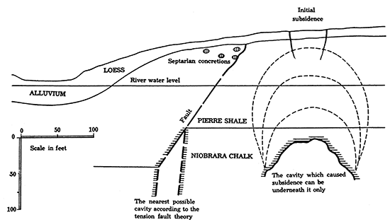
The position of a cavity directly below the initial subsidence is shown on the sketch (Fig. 7). According to the laws of rock subsidence as established by J. Callen, H. Fayole, and others, based on extensive studies in mines, a subsidence over an undermined area of horizontally stratified rock is propagated in a fairly straight vertical direction. A system of subsequently developed domelike cracks is formed, and along these cracks parts of strata tear off and fall down.
The Cretaceous formations at the Smoky Basin cave-in are nearly or quite horizontal; therefore no other than a vertical cave-in over an underground cavity in these formations may reasonably be inferred. The cavity is presumably located in the top layers of Niobrara chalk, but it could be formed equally well in deeper layers of Niobrara. The vertical scale of the sketch is not exaggerated.
The writer is inclined to think that the fault of the Smoky Basin cave-in might be only an indirect cause for the occurrence of the subsidence, its influence being limited to allowing the surface water to enter the chalk through fissures developed in connection with the faulting. Observations in coal mines show that faults are rarely quite dry, but that ordinarily a large or small amount of surficial water moves along the fault planes. The coal-bearing formations are commonly fairly argillaceous, a condition, however, that does not generally lead to a complete sealing of the fault fissures.
The lower part of the Pierre shale, which overlies the Niobrara chalk in the area of the Sharon subsidence, does not consist of clayey shale alone but is made of alternating beds of clayey shale, flaky shale, and porous and rigid pseudo chalky shale. It seems to be quite possible, if not probable, that zones of cracks or breccia, which might develop in places along the fault, provided channel ways through which circulating surficial waters could descend to the Niobrara chalk.
Surficial waters that entered fissures at and around the Smoky Basin fault have certainly been charged with carbon dioxide and thus could aid greatly in the solution of the chalk, but this could be done, also, by water not carbonized at all. Davis justly emphasizes the fact that "limestone is, as compared to sandstone and shale, rather readily soluble in noncarbonated water," and "it is well to bear in mind that some share, perhaps a, large share, in the solutional excavation of caverns may be accomplished, very slowly to be sure, by noncarbonated water" (Davis, 1930, p. 487).
It seems clear that whether underground water in the Niobrara chalk migrated from distant outcrops of the formation or descended directly through the fissures along fault zones, the solution of the chalk would not be uniform. There are doubtless more soluble and more pervious parts of the chalk traversed by various fissures, along which the water would circulate more readily. This would result in differential solution of the calcareous matter in the chalk, which could lead to the formation of caves and could contribute to the collapse of their roofs.
It is quite interesting to note that according to Weller, who studied the origin of caves in various limestones, those "comparatively porous limestones which offer free passage for the water in all directions do not commonly develop sink holes and caves unless, for some reason, the circulation of the water is concentrated locally," while, on the other hand, "sink holes and caves are developed to their maximum perfection" in beds of limestone "practically impervious to water except along fissures or bedding planes," where "consequently solution is localized along certain lines" (Weller, 1927, p. 45).
It seems apparent to all students of the origin of underground caves that the water that is capable of solution and corrosion of calcareous rocks does not necessarily fill up either the particular paths along which it moves or the caves caused or enlarged by its circulation. Therefore, a subsidence over such a cave; as was true of Smoky Basin cave-in, may have initially a dry bottom, the amount of water in the cave being only enough to fill the space between the blocks and fragments of the collapsed roof, which covered the floor.
It appears to be quite possible that caverns of deformation, such as the tensional fault cavities suggested by Russell, or of a similar sort, could have been actually produced in the comparatively rigid Niobrara, which, as observations show, is much broken into larger and smaller tilted blocks. However, as was shown above, the particular cave-in east of Sharon Springs is not situated above a possible tension cavity in connection with the fault discovered in the wall of the cave-in. It is possible and even probable that in other places the fissures, the fault breccia and similar more-permeable zones along faults served as canals for water circulation and were in places gradually enlarged and finally caved in. However, the cavities produced by faulting could not possibly collapse long after their origin without the action of some undermining water, as was explained above.
In secs. 1, 2 and 3, T. 12 S., R. 39 W., there are four cave-ins in a row, the smallest and the most recent of which (Pl. XL B) is somewhat south' of the center of section 1. These subsidences, which have already been described by Russell (Russell, 1929a, p. 606), are possibly arranged along an arching fault through which the underground water of the Niobrara, which here is about 500 feet below the surface, is circulating. According to James T. Madigan, the cave-in south of the center of section 1 (see Pl. XL B) originated about 1900. This cave-in cuts across the channel of the local draw and is filled with water from the underflow. The next two subsidences west of here are situated on the north side of the valley, their rims being about at the base of the valley slope. They have dry bottoms, and their walls are only moderately steep owing to prolonged erosion. The fourth and westernmost subsidence of this group is much larger in area but is very shallow, which is probably, at least in part, due to a much older origin of the cave-in. The gradual filling of caveins of this type by the slumping of the walls is described in detail by Johnson, who studied similar subsidences in Meade county, Kansas (Johnson, 1901, pp. 705-712).
Though the arrangement of the four subsidences just mentioned along a curved line suggests a group of underground cavities along a fault, there are other subsidences in Wallace County which are either isolated or are arranged in irregular groups. A group of large and ancient subsidences. in the southeastern corner of T. 12 S., R. 38 W., has no particular order of arrangement. The bottoms of these basins are usually wet, being on the level of sheet water of the sandy base of the local loess formation.
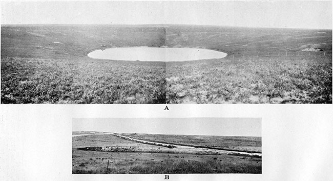
The solitary Old Maid's Pool (Pl. XLI A), in the northeast corner of sec. 30, T. 12 S., R. 40 W., is perfectly circular and has always water at about the same level, which is also apparently the level of the sheet water at the base of the loess formation. Pierre shale is exposed on the south side of the basin.
Another large basin, probably an old cave-in, is on the middle of the line between secs. 9 and 16, T. 12 S., R. 42 W. The bottom of this basin is usually wet.
North of Wallace County two subsidences are reported by Russell (Russell, 1929a, p. 606), six miles south of Goodland, near state highway No. 27, and south of Wallace County the nearest known cave-ins are in Hamilton County. The latest sudden subsidence in this area occurred late in 1929 and was reported by Mr. Herbig, of Irene post office, in the following words:
"We are having lots of snow. Some wind. On Sunday morning, November 10, 1929, there occurred a strange thing in the way of a sink hole seven miles northwest of here. On the northeast corner of sec. 22, T. 25 S., R. 43 W., a. place about 20 feet in diameter sank about 20 feet deep." [From personal letter of November 12, 1929, to S. D. Flora, of Topeka, forwarded to state geologist.]
The place of the subsidence was visited by K. K. Landes in the summer of 1930, by Bass, Stryker and Ver Wiebe on August 29, 1930, by the writer early in October of the same year and again by the writer in company with Landes April 10, 1931. The subsidence was described in detail by Bass (Bass, 1981, pp. 201-205) and by Landes (Landes, 1981, p. 708). The circular hole, with vertical walls rising about 6 feet above the water level, was about 50 feet in diameter when visited by the writer in 1930 (Pl. XLI B). According to Herbig the hole was dry until after heavy rains. The subsidence is situated at the edge of the bottom of a dry valley that runs from here southeastward. Many similar but more ancient sink holes are scattered along this valley. One of these, named "Devils Hole," is in the SW SE, sec. 30, T. 25 S., R. 42 W., and was, according to Herbig, about 15 feet deep forty-four years ago, but now is only about 10 feet deep.
At the time of the last visit of Landes and the writer the slumping of the walls of the hole advanced to such an extent that the public road has been engulfed across its entire width. This slumping also exposed the shale, which is undoubtedly Benton shale, in the eastern side of the hole beneath alluvium. This observation permits us to conclude that "the original cavern was formed in pre-Dakota strata, because very little soluble rock is found in the Graneros or Dakota formations (Landes, 1981, p. 708). Landes concludes that "dissolution of soluble preDakota strata, possibly salt but more probably gypsum, caused the formation of the original cavern underlying the Hamilton County sink."
Plate XL--A, Smoky Basin cave-in as it appeared in 1929. View of eastern wall of the basin, showing traces of the initial subsidence and the line of fault. In tile NE SE, sec. 33, T. 13 S., R. 39 W. B, Thirty-year-old cave-in across the channel of a small intermittent creek. In the S2, sec. 1, T. 12 S., R. 39 W., looking southeast. C, Circular basin and "gates" in Ogallala. In the NE SW, sec. 27, T. 12 S., R. 41 W., looking south.
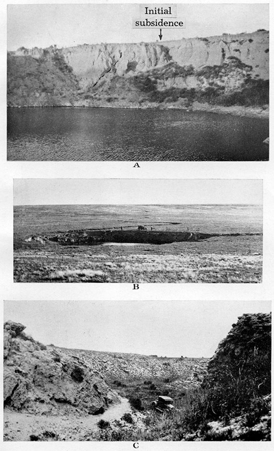
Plate XLI--A, Old Maid's Pool, an old cave-in. In the northeast corner of sec. 30, T. 12 S., R. 40 W. B, Recent subsidence. which undermined county road in the northeast corner of sec. 22, T. 25 S., R. 43 W., in Hamilton County, Kansas. Photograph taken in May, 1930.
Prev Page--Mineral Resources || Next Page--Bibliography
Kansas Geological Survey, Geology
Placed on web Nov. 6, 2014; originally published April 1, 1931.
Comments to webadmin@kgs.ku.edu
The URL for this page is http://www.kgs.ku.edu/Publications/Bulletins/18/07_subs.html