![]()
Prev Page--Contents || Next Page--Stratigraphy
Introduction
Purpose and Scope of Investigation
Published work pertaining to the Graneros Shale of Kansas consists largely of generalized lithologic descriptions that are scattered through several county reports published by the State Geological Survey of Kansas. Except for studies in Russell County by Rubey and Bass (1925) little of the stratigraphic and almost nothing of the geographic distribution of the fauna has been reported in print. No prior attempt has been made to synthesize field and laboratory data gathered from exposures along the entire outcrop belt.
The present study is based on field investigations made during the summers of 1960 to 1964 and on laboratory analysis of rock samples and fossil collections assembled in the course of the fieldwork. Extensive study of Graneros exposures furnished a primary basis for detailed understanding of lateral and vertical stratigraphic relationships that are depicted graphically in Plate 1 (in pocket). Exhaustive search for macroinvertebrate fossils was made in order to establish paleontological zonation and correlation of the formation. The main objective of this study is interpretation of paleoecology and depositional environment of the Graneros in central Kansas and determination of the significance of the formation with respect to the general sedimentary history of the Western Interior Sea during Late Cretaceous time.
It is hoped that this work will furnish a framework, as well as a stimulus, for future studies, foremost among which might be geochemical studies of paleosalinity and paleotemperature of the Graneros Shale.
Previous Work
Prior to 1897 only casual reference had been made to Kansas rocks now assigned to the Graneros Shale. The earliest definitive description of the unit, then called "the Bituminous Shale Horizon," is that by Logan (1897, p. 216) in which general features such as thickness, color, and structure of the shale are recorded. Logan (1899a, p. 84) expanded this description and correlated the shale with the Graneros of Colorado. The most comprehensive previous description of the Graneros Shale in Kansas is that by Rubey and Bass (1925, p. 51-54) in Russell County. Their work emphasized lithologic and paleontologic characters of the Graneros and such additional information as its manner of exposure and distinguishing features. Other useful descriptions of the Graneros are included in reports on the geology of Ellis and Hamilton counties by Bass (1926) and Ness and Hodgeman counties by Moss (1932). The work of Plummer and Romary (1942) does not treat the formation specifically or in detail but contributes generally to knowledge of Graneros lithology, correlation, and environment of deposition in central Kansas. Among the county groundwater bulletins issued by the State Geological Survey of Kansas in recent years several include brief summaries of Graneros stratigraphy and some include measured sections of the formation. As part of a subsurface study of Mesozoic rocks in western Kansas, Merriam (1957a) published a brief description of the Graneros Shale and indicated subsurface distribution of the formation on several correlation charts. Merriam, et al. (1959) described the lithology and fossils of the Graneros Shale in a core from Cheyenne County. The position of the Graneros Shale in the first cycle of late Cretaceous deposition in Kansas has been discussed by Hattin (1962a, 1962b, 1964 [19661. Previous studies of Graneros fossils are discussed under separate title elsewhere in this report.
Location and Description of Area
Geography
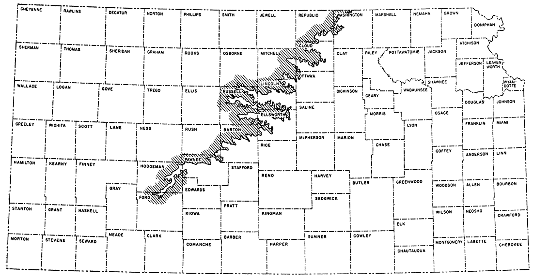
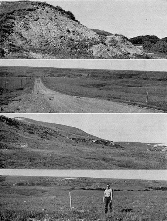
In central Kansas the Graneros Shale outcrop area trends almost exactly northeastward from the southwestern terminus in Ford County to the Nebraska border in Washington County and occupies parts of thirteen intervening counties (Fig. 1). The outcrop area is approximately 210 miles long and a maximum of about 55 miles wide across Ellsworth and Russell counties, measured perpendicular to the northeast-southwest trend. Several major streams cross the outcrop, including, from south to north, the Pawnee River, Walnut Creek, the Smoky Hill River, the Saline River, the Solomon River, and the Republican River. Among the best natural Graneros exposures are those along and in tributaries to Sawlog Creek (a southern tributary to Pawnee River), Smoky Hill River (Fig. 2, A), and Saline River, especially in bluffs capped by Greenhorn Limestone. Exposures are poor in the northern counties owing to Pleistocene deposits and heavier vegetation and in the area between northern Barton County and central Hodgeman County owing chiefly to relatively gentle terrain.
Figure 1--Map showing outcrop of the Graneros Shale in central Kansas.
Interstream areas in the outcrop region are mainly flat to gently rolling uplands (Fig. 2, B) largely underlain by Greenhorn Limestone and devoted mostly to the raising of wheat. In contrast, the Graneros outcrop generally forms a relatively steep slope (Fig. 2, C) in a narrow belt along valley walls (Fig. 2, D) and upland margins, and the land is devoted almost exclusively to pasturage. Oil is produced in eight counties along the central and southern parts of the outcrop, the most notable being Russell, Ellis, and Barton. Several bulletins of the State Geological Survey of Kansas describe ground-water conditions in the counties along the Graneros outcrop belt but the Graneros Shale is not an aquifer.
Figure 2--Topographic expression of the Graneros Shale and adjacent formations. A, Natural exposure of Graneros Shale on south side of Smoky Hill River, sec. 26, T 15 S, R 16 W, Ellis County (Loc. 21). B, View from sec. 36, T 12 S, R 15 W, Russell County, looking southeast across Salt Creek valley toward upland surface developed on Greenhorn Limestone. C, Slope (top center) developed on Graneros Shale; Dakota Formation exposed below. View toward west in sec. 1, T 13 S. R 15 W, Russell County. D, Dakota, Graneros (covered), and Greenhorn in south wall of Salt Creek Valle)". View toward south from sec. 36, T 12 S, R 15 W, Russell County.
General Geology
The Graneros Shale lies at the base of the Colorado Group, which in Kansas is subdivided as follows:
| Colorado Group | ||
| Niobrara Chalk | ||
| Smoky Hill Chalk Member | ||
| Fort Hays Limestone Member | ||
| Carlile Shale | ||
| Codell Sandstone Member | ||
| Blue Hill Shale Member | ||
| Fairport Chalk Member | ||
| Greenhorn Limestone | ||
| Pfeifer Shale Member | ||
| Jetmore Chalk Member | ||
| Hartland Shale Member | ||
| Lincoln Limestone Member | ||
| Graneros Shale | ||
The Graneros of central Kansas is underlain conformably by the Dakota Formation and is overlain, with demonstrable stratigraphic hiatus, by the Greenhorn Limestone. At the southern end of the outcrop the Graneros is overlain locally by the Ogallala Formation (Pliocene) and in some measured sections along the Smoky Hill and Saline River valleys the Graneros is overlain by Pleistocene terrace alluvium. Pleistocene loess overlies the Graneros in many areas at the northern end of the outcrop.
Regional dip on top of the Dakota Formation in the Graneros outcrop belt is generally northward at approximately 6 to 7 feet per mile (Merriam, 1957b). The configuration of this surface is complicated by anticlinal and synclinal structures that lie within the outcrop belt (Merriam, 1958).
The Graneros outcrop lies mostly in the central part of the Smoky Hills section of the Dissected High Plains between hilly terrain developed on Dakota rocks to the southeast and a low, discontinuous, intricately dissected escarpment held up by Greenhorn rocks to the northwest. Topographic expression of these two features is best developed in areas of greatest relief adjacent to the major streams that cross the area. None of the major east-west highways pass close to high bluffs along the larger streams so the average traveler remains unaware of the considerable relief and extensive rock exposures in and adjacent to the Graneros outcrop. Local relief exceeds 300 feet in northeastern Russell County and much spectacular scenery is the result of stream erosion of Cretaceous strata in this and adjacent counties. Dissection of the Graneros Shale by major streams and their tributaries has produced a highly digitate outcrop, and locally extreme thinning of the outcrop in upstream areas is occasioned by low stream gradients in combination with low dip.
The width of the Graneros outcrop area is generally less than a quarter of a mile but locally exceeds one mile. Outcrop width is controlled almost entirely by topography rather than by changes in dip or stratigraphic thickness. Where local relief is high, as along the Saline River, the Smoky Hill River, and Sawlog Creek, the outcrop is commonly less than 100 feet wide. Except for a few road cuts, exposures in large interstream areas are sparse and incomplete. Few beds in the Graneros are sufficiently resistant to retard erosion but, probably because of small stratigraphic thickness, the formation generally lacks the miniature badlands that are so common in its younger analogue, the Blue Hill Shale.
Procedure
Field study of the Graneros Shale was accomplished during parts of each summer from 1960 to 1964. Exposures were located by means of reference to published work, by personal contact with other geologists, and by systematic traversing of the outcrop area. The Geologic Map of Kansas (Moore and Landes, 1937), maps accompanying various reports of the State Geological Survey of Kansas, State Highway Commission county plat maps, maps in U. S. Geological Survey construction-materials circulars, and U. S. Geological Survey topographic maps formed the basis for planning the traverses.
Stratigraphic sections were measured with a hand level and stadia rod or a steel tape. Most measurements were made to the nearest tenth of a foot, but thin and very thin units, such as sandstone, limestone, and bentonite beds were measured to the nearest hundredth of a foot. Each measured section was subdivided into sedimentary units of uniform lithology, limited vertically by changes that are readily detected in the field. The dip and azimuth of directional sedimentary structures were made with a Brunton compass wherever possible. Exposures were ditched with a trench pick as necessary to permit the study of a continuous section of rock.
Each sedimentary unit was described separately, and lithology, thickness, color, fresh and weathered, degree of induration, character of bedding, fossils, secondary minerals, sedimentary structures, and other pertinent data were recorded. Colors are based on the Rock Color Chart prepared by Goddard, et al. (1948). Fossils were collected from nearly all places containing identifiable organic remains, but no attempt was made to collect all the material available at each exposure. Fragile specimens were covered with a protective coating of alvar and packaged in tissue paper to insure safe transport. Six key sections, each representing the entire or nearly entire thickness of the formation, were selected for systematic sampling. Measured units of shale, bentonite, and poorly indurated sandstone and siltstone were ditch sampled; hand samples for thin-section study were collected from lithified sandstone and limestone units. Additional hand samples were collected from other localities to insure laboratory study of each kind of rock represented in the formation. Hand specimens of sedimentary structures were collected for further study and for purposes of photography.
In the laboratory, thin sections were cut from samples of sandstone, siltstone, limestone, bone beds, and concretionary structures and point counts were made on thin sections of the more common rock varieties. Photographs were prepared from representative thin sections. Several samples of poorly indurated sandstone were disaggregated and sieved to determine grain-size distribution. Shale samples from key sections and a number of other localities were washed for study of the microfossils. Several shale samples were analyzed chemically for pyrite, gypsum, and organic-carbon content. Clay minerals and quartz content of shale samples from key sections and selected bentonite samples were determined by X-ray diffraction techniques.
The following text contains some descriptive terms that have widely divergent usages, so these terms are explained below. Bedding terminology is that cited by Dunbar and Rogers (1957, p. 97). Grain sizes mentioned in field and laboratory descriptions are based on the Wentworth scale. The term "shale" is used throughout the text for fissile, clayey sedimentary rocks. In addition, it should be noted that color codes are shown in parentheses only after names for which two colors appear in the Rock Color Chart (Goddard, et al., 1948). The sample-identification code used in this report is based on alphabetic designation of age and formation, followed by locality number, followed by alphabetic unit designations lettered from the base upward. Thus KG-1-A should be read "Cretaceous, Graneros, Locality 1, basal unit."
Acknowledgments
It is my pleasure to thank my former students, C. B. Hatfield, D. E. Hall, Judith G. Clark, and L. E. Sponsel, each of whom served, during parts of one or more summers, as my field assistants. Dr. Hatfield also made most of the X-ray determinations of clay minerals. I would also like to thank Norman Sohl, of the United States Geological Survey, for his identifications of Graneros gastropods, and Don Eicher, of the University of Colorado, for identifying a representative suite of Graneros foraminifers. I am most grateful to W. A. Cobban, of the United States Geological Survey, and E. G. Kauffman, of the United States National Museum, each of whom visited me in the field on separate occasions and discussed at length many aspects of Graneros paleontology and stratigraphy in other states. Both of these friends aided me in the identification of Graneros macroinvertebrate fossils, and Dr. Cobban reviewed the manuscript. Thanks are also due Norman Plummer of the State Geological Survey of Kansas for his aid in locating exposures of the Graneros Shale. Chemical analyses of shale samples and X-ray determinations of alunite, jarosite, and bentonite samples were made under the direction of R. K. Leininger, of the Indiana Geological Survey, and C. W. Beck, of Indiana University, respectively, and I thank them for these kindnesses. Special thanks are given the following staff members of the Geology Department, Indiana University: Leonard Neal, for preparation of thin sections; Bill Moran and John Peace, for final drafting; George Ringer, for preparation of photographs; Ellen Freeman, for library assistance; and Janet Griffin, for preparation of rough and final drafts of the typescript. My sincerest appreciation is extended to my longtime friend and colleague, D. F. Merriam, of the State Geological Survey of Kansas. His enthusiasm and encouragement are largely responsible for the completion of this study.
Prev Page--Contents || Next Page--Stratigraphy
Kansas Geological Survey, Geology
Placed on web Dec, 15, 2014; originally published December 1965.
Comments to webadmin@kgs.ku.edu
The URL for this page is http://www.kgs.ku.edu/Publications/Bulletins/178/02_intro.html