![]()
Prev Page--Ground Water Formations || Next Page--Ground Water
Geomorphology
Stream Development
The topographic features in the area of this report are the products of Pleistocene erosion and deposition. At the close of Pliocene time, the area from the Rocky Mountains to the Flint Hills was a nearly featureless aggradational plain crossed by streams flowing toward the east. During the formation of this plain in central Kansas the Cretaceous rocks were buried under a mantle of debris, which attained a thickness of 300 feet but thinned sharply toward its eastern margin. The remnants of the Ogallala Formation, which was deposited by these streams, cap the divides between the main streams in central Kansas.
In early Pleistocene (Nebraskan) time a drainage system developed on the Ogallala aggradational plain and erosion removed a large amount of these deposits. The main streams probably flowed south along the softer shales between the more resistant Cretaceous limestones that were uncovered by erosion. These streams cut valleys as much as 80 feet below the top of the Ogallala Formation (Fig. 8) and left alluvial deposits that now cap the ridge extending southeastward from Antonino and also left the unconsolidated deposits in a widespread area north of Big Creek in the vicinity of Victoria. Some of the deposits in the vicinity of Victoria may be colluvium overlying a surface graded to a terrace or Hood plain of the major early Pleistocene stream that flowed southward across this area. Stream deposits that may be a continuation of those in the Victoria and Antonino areas were noted at Galatia in northwestern Barton County by Latta (1950, p. 68). Little is known about the relief of the surface during the Nebraskan Stage.
Figure 8--Stages in development of Smoky Hill Valley.
By Kansan time erosion had removed much of the Ogallala deposits in the outcrop area of the Carlile Shale (Pl. 1), and the present drainage system was being established. At that time streams occupied Smoky Hill and Big Creek valleys, as shown by deposits of Pearlette volcanic ash in both valleys. In eastern Trego County and western Ellis County the volcanic ash and associated deposits of the Sappa and Grand Island Formations fill a narrow channel, which was cut into the Carlile Shale and was covered by a widespread younger alluvial deposit. The stream that cut this channel may have been of the approximate size of the modern Smoky Hill River in southern Ellis County. Maximum depth of bedrock cutting during this interval was about to the level of the present river, nearly 300 feet below the top of the Ogallala Formation. Deposits of Pearlette volcanic ash west of Hays near Yocemento suggest that a stream of Kansan age occupied the approximate position of Big Creek. Volcanic ash in a locality in the southeastern part of sec. 17, T. 14 S., R. 19 W., is unrelated to either of the two major streams. This ash may be in a valley that was tributary to ancestral Smoky Hill River. Its location between two nearby escarpments of the Fort Hays Limestone member gives a good indication of the amount of erosion since the ash was deposited and the amount of escarpment retreat since Kansan time.
The events immediately following the cutting and filling of the narrow Kansan channel along Smoky Hill River are not entirely clear. During Illinoisan time a major stream flowing along the Smoky Hill Valley deposited the material underlying the widespread Pfeifer Terrace and overlapping the Kansan channel fill (Pl. 3, Fig. 7, 8). The broad shale surface beneath the Illinoisan deposits may have been beveled by the stream or it may have been a pediment surface graded to the Kansan channel during late Yarmouthian time and modified slightly as the Illinoisan rocks were deposited. The thick widespread sand and gravel deposits beneath the Pfeifer Terrace are correlated with the Crete Formation. In places these deposits grade upward into stratified silt, which is probably the lower part of the Loveland Formation. Thin discontinuous deposits of loess overlie Cretaceous rocks in the upland. The loess was carried into the area by winds from the Hood plains of glacier-fed streams. Loess of Illinoisan and early Sangamonian age is widespread over north-central Kansas and extends as far south as Rice and McPherson Counties (Frye and Fent, 1947). In much of central Kansas, late Sangamonian time was a period of equilibrium when very little erosion took place and was ideal for the formation of the well-developed Sangamonian soil at the top of the Loveland Formation. Inasmuch as evidence of a soil of Sangamonian age has been noted at only a few localities in this area, erosion may have been the dominant physical process here at the time the Sangamonian soil was being developed elsewhere.
During early Wisconsinan time, silt from the Hood plains of Platte and Republican Rivers was drifted over north-central Kansas by strong northwesterly winds (Swineford and Frye, 1951). Early Wisconsinan loess, the Peoria Formation, has been recognized only locally in the report area, and it is thinner and more discontinuous than in areas farther north and west (Frye and others, 1949, fig. 2).
During Wisconsinan time, Smoky Hill River intrenched its valley completely through the Illinoisan deposits and 60 to 80 feet into the underlying shale (Pl. 3, Fig. 8). It is not known whether downcutting took place throughout the Wisconsinan or mainly during one substage. After valley cutting, the alluvial deposits in the inner valley of Smoky Hill River were laid down and the Schoenchen Terrace was formed. The upper part of the deposits beneath this surface is late Wisconsinan, but some of the basal sand and gravel in the buried valley may be early Wisconsinan in age. Rapid accumulation of material during the early phase of deposition is indicated by cedar logs and limbs found in the lower gravel during excavation for the Cedar Bluff dam and by fragments of soft shale mixed with resistant rock materials.
The low terrace along Big Creek is probably of late Wisconsinan age also and was formed after an interval of valley cutting similar to the Wisconsinan interval in the Smoky Hill Valley. The record of events in the Big Creek valley is not as clear as in the Smoky Hill Valley because deposits of the various stages in the Pleistocene have not been differentiated. Downcutting during each interval of erosion was almost confined to earlier Pleistocene rocks, and intrenchment of the bedrock was not so pronounced as along Smoky Hill River. Pearlette volcanic ash in Big Creek valley indicates that the valley has been the site of a major stream since Kansan time. Probably the post-Kansan history of the valley is similar in most respects to that of the Smoky Hill Valley.
Although erosion has been the dominant process during Recent time, very little bedrock has been eroded and only a small amount of late Wisconsinan material has been removed from the valleys of Big Creek and Smoky Hill River. Locally, as much as 30 feet of material has been eroded during dissection of the Schoenchen Terrace. Accumulation of 10 to 15 feet of sand and gravel on the Hood plain followed the period of erosion or occurred simultaneously with the later part of the erosion. Along Big Creek, Recent erosion was restricted to the silty part of the late Wisconsinan terrace deposits and was accompanied by the deposition of several feet of silty material on the Hood plain. Modern Hoods such as those of 1951 have added a small amount of silt to the surface of the late Wisconsinan terrace of Big Creek.
Pediments
In 1942 Frye and Smith described pediment-like slopes in the High Plains along Cimarron River in Seward County and along Smoky Hill River in Logan and Gove Counties. In Logan County, these slopes are developed in the homogeneous nonresistant Smoky Hill Chalk member of the Niobrara Chalk and are graded to the terrace along Smoky Hill River. On the upland side in many places they blend imperceptibly into the valley walls, but locally they end abruptly at the foot of cliffs formed in resistant chalk beds. In western Ellis County and eastern Trego County similar slopes have developed in the Carlile Shale. They grade into the Pfeifer Terrace surface so imperceptibly that the boundary between the two features can not be determined precisely. On the upland side they locally grade into and mask the escarpment formed by the basal beds of the Niobrara Formation so that a graded slope is developed from the escarpment to the high terrace surface. At many places pediments are mantled by a thin layer of colluvium consisting of a mixture of loess, weathered shale, and chalk fragments. Locally, a pediment may be dissected by erosion and a series of smaller pediments graded to lower levels may be developed on the eroded part.
Plate 9 shows a remnant of a partly dissected pediment in southwestern Ellis County in sec. 8, 9, 16, and 17, T. 15 S., R. 20 W. This surface was graded to the escarpment of the Fort Hays Limestone member at the south and to the Pfeifer Terrace at the north. Erosion subsequent to pediment formation has formed a badland area about half a mile wide between the pediment remnant and the limestone escarpment, and down cutting of the Smoky Hill Valley has formed an escarpment between the pediment and the valley (Fig. 9). Late Pleistocene erosion has intricately dissected the shale on the south and east sides of the pediment remnant and formed badlands that are separated from the pediment by a pronounced escarpment. Although streams are beginning to erode the pediment, the surface at the south end is still relatively undissected and probably has been protected by the veneer of colluvium.
Plate 9--Aerial view of central part of T. 15 S., R. 20 W., showing large pediment remnant, "badlands" developed on Carlile Shale, escarpment formed by Fort Hays Limestone member, and segment of Smoky Hill Valley. Arrow points north and is 1/2 mile long. (Features are labeled on Fig. 9.)

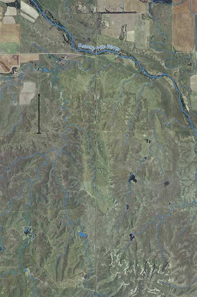
Figure 9--Map of area shown in Plate 9.
Frye and Smith (1942, p. 218) concluded that the High Plains pediments were formed by slope processes, especially erosion by closely spaced minor streams, sheet wash, and weathering creep. The grading of these surfaces to the Pfeifer and other terrace levels suggests that each pediment formed at the same time as the alluvial surface to which it is graded, or at least before extensive erosion of the terrace. The pediments in this area probably were formed at different times during the Pleistocene, and the formation of multiple pediments has been a continuing process.
Asymmetric Valleys
Bass (1926, p. 13), in describing the topography of Ellis County, stated concerning the main streams: "…their valleys are markedly steeper on the south sides than on the north sides." Later (1929, p. 17-23), he discussed in detail the origin of asymmetric valleys in Kansas and concluded that the south-facing slopes of eastward-flowing streams were exposed to greater physical weathering in the form of alternate wetting and drying, freezing and thawing, wind action, and possibly greater chemical weathering because of more heating than the north-facing slopes. In this area major valleys seem to be asymmetric where their streams are against one bedrock wall for long stretches of the stream and the entire terrace area is on the other side of the stream.
Big Creek Valley is asymmetrical throughout the area shown on Plate 1 because the south wall is formed by Cretaceous bedrock and the north slope by the broad Pleistocene high terrace. Smoky Hill Valley is asymmetrical in southwestern Ellis County where pediment slopes grade into the Pfeifer Terrace on the north side of the river, and the bedrock slopes or badlands developed in the Carlile Shale form the south wall. East of Schoenchen the Smoky Hill Valley is almost symmetrical except locally, as near Schoenchen and near Pfeifer, where the river is against the north bedrock wall and the slope on the south side is gentle (Pl. 3).
Prev Page--Ground Water Formations || Next Page--Ground Water
Kansas Geological Survey, Geology
Placed on web Feb. 4, 2013; originally published March 1961.
Comments to webadmin@kgs.ku.edu
The URL for this page is http://www.kgs.ku.edu/Publications/Bulletins/149/05_morph.html