![]()
Prev Page--Contents || Next Page--Geography, Geology
Introduction
Purpose of Investigation
The investigation of this report area in Smoky Hill River valley in Trego, Ellis, and Rush Counties is a part of the program for the development of the Missouri River Basin by the United States Department of Interior. In Kansas, the ground-water investigations made under the Missouri Basin Program have been coordinated with those made under the co-operative ground-water program begun in 1937 by the United States Geological Survey, the State Geological Survey of Kansas, the Division of Sanitation of the Kansas State Board of Health, and the Division of Water Resources of the Kansas State Board of Agriculture. The present status of investigations resulting from these programs is shown in Figure 1.
Figure 1--Index map of Kansas showing area discussed in this report and other areas for which ground-water reports have been published or are in preparation.
The purposes of this investigation were: To determine the natural occurrence and quality of the ground water before conditions were disturbed by irrigation developments; to determine the availability of ground water and its suitability for domestic, stock, municipal, and irrigation uses; to learn the geologic factors that control the occurrence of ground water; and to determine the chemical quality of the water in relation to geologic formations.
Location and Extent of Area
The area described in this report is a narrow strip extending from Cedar Bluff dam in southeastern Trego County to the eastern boundary of Ellis County. It includes the valleys of Smoky Hill River, Big Creek, and North Fork of Big Creek and the intervening and adjacent uplands. The area is about 37 miles long and ranges in width from 4 to 13 miles. It contains about 365 square miles.
Previous Investigations
The Cretaceous stratigraphy of Kansas has been a subject of interest to geologists since the railway explorations and the Hayden territorial surveys of the 1860's. Adams (1898) has given a historical summary of the early studies of the Cretaceous rocks in Kansas. Many of the early field investigations and fossil collections were made by Mudge, who in 1878 presented the geologic outlines of western Kansas, using the stratigraphic classification set up by Meek and Hayden along Missouri River in Nebraska in 1862. Haworth (1897a) described the physiography of western Kansas and (1897b) the Tertiary rocks in Kansas. The Upper Cretaceous rocks were described by Logan (1897), who recognized several formations first described and named by Gilbert (1896) from exposures along Arkansas River in Colorado. Williston (1898, 1900) described the vertebrate paleontology of the Cretaceous rocks. In a report on the mineral waters of Kansas, Bailey (1902) presented analyses of water derived from Cretaceous rocks.
In 1913 Haworth described the occurrence of ground water in the Dakota Formation (p. 91-99) and in the Tertiary rocks (p. 57-68) of Kansas. Bass described the geology of Ellis County in detail (1926, p. 11-52) and included a short section on ground water. Frye and Brazil (1943) reported on ground water in the oil-field areas of Ellis and Russell Counties, which include the northeastern part of this area. Recent reports by Byrne, Coombs, and Bearman (1947, 1949) describe the occurrence of construction materials in this area.
Methods of Investigation
This project was started in the summer of 1946, as a part of the Missouri Basin program of the U. S. Department of Interior. Many wells were inventoried and an observation-well program was established in the eastern part of the area. During four months in the summer and fall of 1949, hydrologic and geologic data were collected in the area. The well inventory was completed, water levels were measured in many of the wells listed in Table 11, and the observation-well program was expanded to include the western part of the area. Depth to water was measured from a fixed point at the top of each well by steel tape graduated to hundredths of a foot. The altitude of the measuring point for each well was determined by level parties of the Bureau of Reclamation and the U. S. Geological Survey using a spirit level. The wells shown on Plate 2 were located by odometer, hence locations are accurate to about 0.1 mile.
In 1949, the geology was studied in the field, and the geologic map (Pl. 1) was prepared on aerial photographs made for the U. S. Department of Agriculture. Forty-nine test holes were drilled to determine the character, thickness, and extent of the water-bearing formations. These test holes penetrated the entire thickness of Pleistocene deposits and a few feet of the underlying bedrock (Pl. 3). The test holes were drilled with the hydraulic-rotary Grilling machine owned by the State Geological Survey and operated by W. T. Connor, B. M. Yazza, and D. W. Berry. Samples of the drill cuttings collected in the field by D. W. Berry were examined with a binocular microscope in the office, and the field logs were modified as necessary. Additional data on the character and thickness of the water-bearing formations were obtained from field examination of outcrops and from residents in the area. In 1956, 80 test holes were jetted in Pleistocene deposits in and adjacent to Smoky Hill River valley in the western part of the area.
Chemical analyses of samples of water collected from 49 wells were made in the laboratory of the Quality of Water Branch at Lincoln, Nebraska. The analyses of the public water supplies for the cities of Hays and Victoria were made by the Division of Sanitation of the Kansas State Board of Health.
Well-Numbering System
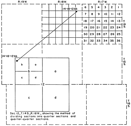
The well-numbering system used in this report utilizes the General Land Office survey according to the following sequence: Township, range, section, quarter section, and 40-acre tract within the quarter section. The numbers used to designate the township, range, and section are those assigned in the General Land Office survey. The quarter sections and 40-acre tracts are lettered a, b, c, or d in a counterclockwise direction beginning with the northeastern quadrant. For example, well 14-18-12bb (Fig. 2) is in the NW NW sec. 12, T. 14 S., R. 18 W. If two or more wells or test holes are in the same 40-acre tract, they are numbered serially in the order in which they were inventoried; for example, 14-22-25da1, -25da2.
Figure 2--Sketch illustrating well-numbering system used in this report.
Acknowledgments
Appreciation is expressed to the residents of the area for providing information about ground-water supplies and for aiding in the collection of field data. Special thanks are given Ben Brungardt, city manager of Hays at the time this study was made, and to the water superintendents of Hays and Victoria for information about their city water supplies and the geology of the well fields.
The manuscript of this report has been reviewed critically by several members of the U. S. Geological Survey and the State Geological Survey of Kansas; by Robert V. Smrha, Chief Engineer, and George S. Knapp, Engineer, of the Division of Water Resources of the State Board of Agriculture; by Dwight F. Metzler, Director, and Willard O. Hilton, Geologist, of the Division of Sanitation of the Kansas State Board of Health; and by Robert L. Smith, Executive Secretary, and William E. Steps, Engineer, of the State Water Resources Board. Chemical analyses of water samples from the municipal supplies of Hays and Victoria were made by Howard Stoltenberg, Chemist, of the State Board of Health.
Prev Page--Contents || Next Page--Geography, Geology
Kansas Geological Survey, Geology
Placed on web Feb. 4, 2013; originally published March 1961.
Comments to webadmin@kgs.ku.edu
The URL for this page is http://www.kgs.ku.edu/Publications/Bulletins/149/02_intro.html