| Original published in W.W. Hambleton, ed., 1959, Symposium on Geophysics in Kansas: Kansas Geological Survey, Bulletin 137, pp. 143-152 | ||
Chief Geophysicist, Aero Service Corporation and Canadian Aero Service, Ltd.
The complete article is available as an Acrobat PDF file.
The aeromagnetic data obtained along the north border of Kansas by Aero Service Corporation in 1948 have been analyzed to determine the depth and structure of the Precambrian basement rocks and to compare these data with depths and structure obtained from wells and with Bouguer gravity anomaly data.
The depth to the basement obtained from aeromagnetics is in good general agreement with the well depths, considering that the magnetic control from only a single profile was used. There is little or no correlation between Bouguer gravity anomaly and aeromagnetics or basement structure, probably owing to wide separation of gravity stations and the fact that the source of the gravity anomalies may be attributed to the sedimentary rocks.
This paper reports an analysis of the aeromagnetic data that were obtained along the northern border of Kansas in 1948 by Aero Service Corporation (Jensen, 1949) and published without analysis. Illustrations show depths to basement rocks, as determined from aeromagnetic data, and compare these depths with depths to basement obtained from wells along or in the vicinity of the flight line. The well depths to basement rock were obtained from Merriam and Hambleton (1956).
The Bouguer gravity anomaly data were obtained from Woollard's (1943) transcontinental profile. The purpose of introducing the gravity data is to examine the possible relationship between subsurface structure, magnetic anomalies, and gravity anomalies.
Most readers are familiar with the Schmidt type of vertical magnetic balance, but may not be as familiar with the saturable-core magnetometer developed by Gulf Research and Development Corporation for magnetic surveys. These instruments are described and compared briefly.
The vertical magnetic balance used in magnetic ground surveys consists of a sensitive moving element (two parallel magnetized blades) balanced on quartz or sapphire knife edges that rest on quartz bearings. The torque of the vertical component of the earth's magnetic field is counter-balanced by the gravitational torque acting on the system. The angular displacement of the system is proportional to the change in the vertical component of the earth's magnetic field. The sensitive element is housed in an insulated container, and the observations of the angular displacement are made through a telescope. The instrument is extremely sensitive to deviation from a level position and to accelerational motion. The sensitive magnetic element is shown in Figure 1.
Figure 1--The moving system of the Schmidt-type vertical magnetometer.
The saturable-core magnetometer was devised because the magnetic balance, owing to its motion sensitivity, could not be modified for use on aircraft. The sensitive element of the airborne magnetometer consists of a ferromagnetic core, which is approximately saturated by the earth's magnetic field. This saturation field is nulled by current flowing in a coil wound about the core. If the sensitive element is moved to a point where the field increases, the original current flowing in the coil will not null the earth's magnetic field, and a signal of unbalance is detected. The increase in current necessary to null the increase in field is proportional to the increase in the earth's magnetic field. Thus, a continuous recording of changes in the earth's magnetic field can be obtained if variation in nulling current is recorded continuously. A schematic electronic block diagram for the saturable-core recording magnetometer is shown in Figure 2.
Figure 2--Block diagram of saturable-core recording magnetometer. (After Wyckoff, Geophysics, 1948.)
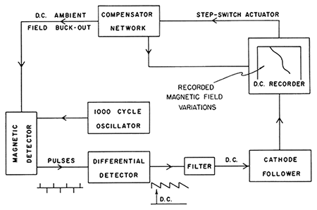
The saturable-core magnetometer measures variation of the earth's total magnetic field rather than the vertical component, inasmuch as large orientation errors are introduced if measurements of the vertical component are attempted. Additional saturable cores orient the sensitive element of the magnetometer in the direction of the earth's magnetic field with greatest accuracy; consequently, orientation errors are of the order of one gamma, the sensitivity required in petroleum exploration.
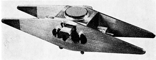
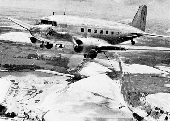
The sensitive element, the orienting saturable cores, which are in a plane perpendicular to the sensitive element, and orienting motors, which maintain the sensing element in a direction parallel to the earth's total magnetic field through the error signals received from the orienting cores, are mounted in a bomblike container. This unit, commonly called a "bird", is shown with its connecting cable and winch in Figure 3. The amplifier and recording units are mounted inside an aircraft; the "bird" usually is towed (Fig. 4) in order to minimize the effects of magnetic fields originating in the aircraft. Small aircraft are now being used because the weight of the unit has been decreased and the sensitive element can be mounted on the aircraft, owing to improved methods of compensating for the effects of the aircraft.
Figure 3--The "bird" housing the sensitive element with sensing motors, and the winch for the airborne magnetometer.
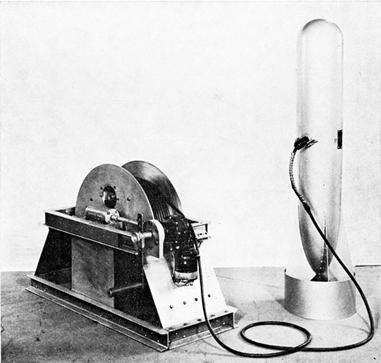
Figure 4--The aircraft in which amplifiers and recording elements are mounted and the towed "bird" of the airborne magnetometer.
In conventional magnetic ground surveys it is relatively simple to position the station where observations are made. These stations are located on a map and the magnetic data are contoured to produce an isomagnetic map of the area. In airborne magnetic surveys no direct ground contact is made, and the data are worthless if the ground position of the observations can not be recovered (located). Thus, it was necessary to devise auxiliary equipment and techniques for mapping the data that were obtained from the airborne magnetometer with ground survey precision.
Airborne magnetometer surveys in petroleum basins usually are made at barometric altitudes such that the average terrain clearance is about 1,000 feet. This terrain clearance reduces or eliminates the effects of magnetic fields due to surface or near-surface materials, but does not greatly reduce the magnetic anomalies caused by the basement rocks. In mineral surveys, a constant terrain clearance of the order of 500 feet is maintained and monitored continuously by an APN-1 recording radio altimeter.
The horizontal position of the aircraft is monitored by a continuous-strip-film camera, which records the flight path of the aircraft. Although the pilot attempts to follow a predestined flight path from strip photos, a monitored record is made of his actual flight. After the flight has been completed, the image on the strip camera print is compared with the image on a photo mosaic, and the actual flight path is used to compile a flight-path map.
The magnetic record, the radio altimeter record, and the strip-film record are correlated, by means of reference marks that are recorded simultaneously on all three records. Hence, when the flight path is recovered, it is possible to locate the exact ground position of the magnetic data.
The speed of obtaining data on the ground is controlled by availability of roads and the type of topography and may range from a few miles to a maximum of about 50 miles per day. Furthermore, the magnetic data are obtained discontinuously because observations are made at stations and coverage is controlled by water cover, jungle cover, and culture.
Airborne survey data are obtained at speeds of 140 or 150 miles per hour. The average speed is reduced to about 100 miles per hour, owing to turn-arounds to return to a parallel flight path in the opposite direction. In addition, airborne magnetometer data are obtained and recorded continuously, and rarely are there gaps in the data because of water or jungle cover or culture. Hence, an airborne magnetometer survey permits "blanketing" an area and obtaining maximum amount of data commensurate with the economics of the particular survey.
Merriam and Hambleton (1956) have discussed the geology along the northern border of Kansas in relation to Jensen's (1949) magnetic profile. Rocks ranging in age from Precambrian to Recent are present in the geologic column, but only sedimentary rocks of Pennsylvanian to Recent age crop out along the flight path. Farquhar (1957) described and reported the distribution of igneous and metamorphic rocks in the Precambrian basement complex. Inasmuch as the airborne magnetometer is affected mainly by the magnetite in the basement rocks, the outcropping sedimentary rocks are not of consequence in this interpretation of the magnetic data.
From west to east, regional geologic structures along the flight path (Fig. 5) include a portion of the Hugoton Embayment, the Cambridge Arch, the Salina Basin, the Nemaha Ridge, and the Forest City Basin.
Figure 5--Flight line, variations of the earth's total magnetic field, the Bouguer gravity anomaly, and the basement structure from aeromagnetics and from wells along north border of Kansas. [Larger version of this figure is available as an Acrobat PDF.]
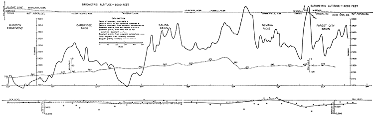
Cursory examination of the total magnetic intensity profile (Fig. 5) shows that the average intensity of the earth's magnetic field decreases to the west. Although the over-all decrease in intensity along the profile is approximately 900 gammas, the gradient is not smooth. An increase of about 400 gammas is observed near Cedar Bluffs, the approximate location of the Cambridge Arch. A second high of the order of 700 gammas between Woodruff, Kansas, and Superior, Nebraska, is at the approximate location of the Salina Basin. Another high of the order of 300 gammas is located between Hubbell, Nebraska, and Summerfield, Kansas. The magnetic level drops to a relatively low intensity on the west flank of the Nemaha Ridge. Relatively sharp magnetic anomalies are superimposed on the regional magnetic low over the Nemaha Ridge. An isolated magnetic high of the order of 800 gammas is observed on the approach to the Forest City Basin. Only at the Cambridge Arch is there any marked coincidence of structural high and magnetic high.
The major magnetic anomalies, with the possible exception of the sharp magnetic anomaly near the Missouri border, probably are caused by differences in the rock of the basement complex. The width of these anomalies ranges from 70 miles for the broad high located at the Cambridge Arch to 40 miles on the approach to the Nemaha Ridge. Intra-basement sources are 10 to 15 miles deep if it is assumed that the anomalies are elongate and at right angles to the flight path, and that the depth to the source of an anomaly is approximately one-fourth the anomaly width. At a depth of 15 miles, however, the normal temperature gradient would raise temperatures to the Curie point (the temperature at which materials cease to be ferromagnetic). Thus, it may be seen that the broad magnetic anomalies do not correspond to known structural features, and the depth calculations, based on broad anomalies, are of questionable value.
Basement rock depths also were determined from analysis of the minor anomalies observed along this profile. The methods described by Agocs and Isaacs (1956) and Peters (1949) and a model comparison described by Vacquier and others (1951) have been used in making these depth determinations. It was assumed that (1) the profile is at right angles to the elongation of the magnetic anomalies; (2) the magnetic anomalies are caused by elongate structures; (3) the sides of the material causing the magnetic anomalies are vertical; (4) the magnetic anomalies are caused by abrupt changes in the magnetite content of the basement rock; and (5) the depth to the source of the magnetic anomalies is proportional to the horizontal extent of the local flank gradients of the magnetic anomalies.
It is to be expected that the simplifying assumptions will introduce relatively large errors in depth determinations; nevertheless, quantitative data may be obtained therefrom. It must be realized also that an areal magnetic survey yields far better depth determinations than a single profile and that these data were obtained at barometric altitudes ranging from 4,000 to 6,000 feet above mean sea level. The purpose of this paper, however, is to compare basement depth determinations from aeromagnetics and well data within the severe limitations imposed by the single profile.
From the Colorado border east to Cedar Bluffs (Fig. 5), the basement depths obtained from the wells and from magnetics show excellent correspondence. From Cedar Bluffs to Woodruff the depths to the basement horizon obtained from magnetics are far greater than the depths obtained from wells. These errors may be due to deviation of anomaly strike direction from right angles to the profile.
From Woodruff eastward to the Missouri border, the correspondence between basement depth obtained from wells and from aeromagnetics is fair. Across the western part of the Salina Basin the calculated basement depths are 1,000 to 1,500 feet shallower than the well depths. In the section between Superior, Nebraska, and Hubbell, Nebraska, the magnetic depth determinations are relatively consistent with well depths, and show a probable deepening of the basin.
East of the Salina Basin the Nemaha Ridge is well outlined by depths obtained from magnetics data, but the depth on its western flank seemingly is abnormally great. The magnetic data indicate a major deep of the order of 5,000 feet below sea level on the approach to the Forest City Basin. The basement depth decreases eastward into Missouri.
Woollard's (1943) Bouguer gravity anomaly profile is compared with the magnetic profile and basement structure (Fig. 5). The route of the gravity traverse was 40 to 70 miles south of the magnetometer flight path; consequently, comparisons may not be completely valid. The Bouguer anomaly shows an increase of about 150 milligals from the Colorado border to a point east of Hubbell, Nebraska. Eastward from Hubbell, the Bouguer anomaly abruptly decreases about 80 milligals and then increases about 25 milligals on a relatively flat gradient to the Missouri border. The 80-milligal Bouguer gravity anomaly discontinuity east of Hubbell does not coincide with an east-flank fault of the Nemaha Ridge, but seemingly it does coincide with the western part of a broad dual magnetic high.
The Bouguer gravity anomaly bears no obvious relation to subsurface structure, and corresponds only with the westward gradient of the magnetic intensity.
There is relatively good agreement between basement depths calculated from aeromagnetic data and well depths at some places. On the east flank of the Cambridge Arch and on the west flank of the Nemaha Ridge, the calculated depths are much greater than the well depths. In the western part of the Salina Basin the calculated depths are 1,000 to 1,500 feet too shallow. One or more of the assumptions used in the calculations could be in error. It was hoped that subsurface structures determined from well or aeromagnetic data would correspond to some degree with the Bouguer gravity anomaly. Furthermore, it was hoped that the major gravity discontinuity east of Hubbell would correspond to a major discontinuity in the basement depth derived from magnetic data. There may be minor indication of this correspondence, but a definite relationship is not clear. Profiles from other places show remarkable correspondence between basement structure, as determined from the aeromagnetics, and the Bouguer gravity anomaly; the correspondence is insignificant for this profile.
The writer wishes to thank W. Lucas of the Magnetic Division of Aero Service Corporation for the original aeromagnetic tape from which the depth analyses were made, and D. C. Fitzsimmons, of Canadian Aero Service, Ltd., for drafting the illustrations. Figure 1 was supplied by Walter Ruska, of Ruska Instrument Corporation, who kindly granted permission for its use.
Agocs, W. B., and Isaacs, K. (1956) Tunis to Lisbon airborne magnetometer profile: Geophysical Prospecting, v. 4, no. 1, p. 10-23.
Farquhar, O. C. (1957) The Precambrian rocks of Kansas: Kansas Geol. Survey Bull. 127, pt. 3, p. 49-122. [available online]
Jensen, Homer (1949) Airborne magnetic profile above 40th parallel, eastern Colorado to western Indiana: Geophysics, v. 14, no. 1, p. 57.
Merriam, D. F., and Hambleton, W. W. (1956) Relation of an airborne magnetic profile to the geology along the Kansas-Nebraska border: Kansas Geol. Survey Bull. 119, pt. 7, p. 251-266. [available online]
Peters, L. J. (1949) The direct approach to magnetic interpretation and its practical application: Geophysics, v. 14, no. 3, p. 290-320.
Vacquier, V., Steenland, N. C., Henderson, R. G., and Zietz, Isidore (1951) Interpretation of aeromagnetic maps: Geol. Soc. America, Mem, 47, p. 1-151.
Woollard, G. P. (1943) Transcontinental gravitational and magnetic profile of North America and its relation to geologic structure: Geol. Soc. America Bull., v. 54, p. 747-790.
Kansas Geological Survey
Comments to webadmin@kgs.ku.edu
Web version Nov. 19, 2013. Original publication date 1959.
URL=http://www.kgs.ku.edu/Publications/Bulletins/137/Agocs/index.html