Kansas Geological Survey, Bulletin 134, part 8, originally published in 1959
Originally published in 1959 as Kansas Geological Survey Bulletin 134, part 8. This is, in general, the original text as published. The information has not been updated.
The Plattsburg Limestone is anomalously thick in the Neodesha-Fredonia area, increasing from an average of about 20 feet to a maximum thickness of 115 feet. Thickening is due to increase in the Hickory Creek Shale (middle member) from 1 to 45 feet, and the Spring Hill Limestone (upper member) from 3 to 88 feet in thickness.
The Plattsburg Limestone and the overlying Vilas Shale have been studied in outcrops in the eastern part of the Neodesha-Fredonia area and have been traced underground in the central and western parts of the area by means of about 200 drillers logs. Nineteen outcrop sections, measured, described, and sampled in detail, form the basis for lithologic and genetic interpretations. About 150 rock samples were studied microscopically by means of acetate peels and enlarged negative photographic prints made from the peels.
The principal cause of thickening of the Plattsburg Limestone is interpreted to be deposition of an extensive, lens-shaped marine bank that rose above the general level of the surrounding sea floor. The bank was at least 14 miles long in a northwest-southeast direction, and about 10 miles wide. Two smaller, detached thickened portions of the Plattsburg Limestone in the area probably represent small banks. A second cause of thickness variations in the Plattsburg Limestone is local structural warping during deposition, which permitted greater thicknesses to accumulate over downwarps and lesser thicknesses over upwarps. Thickness of the Vilas Shale also has been affected by this cause.
Thickness of the Vilas Shale has been observed to be inversely related to thickness of the Plattsburg Limestone at most localities. Part of the Vilas Shale is interpreted to be an off-bank time equivalent of part of the thickened Spring Hill member.
Deposition of the bank is interpreted to have been strongly influenced by lime-secreting organisms, including crinoids, bryozoans, brachiopods, mollusks, and algae. The organisms may have influenced deposition of silt and clay (Hickory Creek member) by exerting a sediment-binding effect, and probably helped stabilize slopes at least as great as 7° on the edges of the bank. In addition, they contributed large quantities of calcareous material to the upper part (Spring Hill member) of the bank.
Where thick, the Spring Hill member of the Plattsburg is divided into three tabular lithologic subdivisions in regular vertical sequence. The lower subdivision contains abundant irregular fragments and pellets, much of it seemingly of algal origin. The middle subdivision contains abundant visibly crystalline calcite intimately associated with encrusting calcareous algae. The upper subdivision contains abundant calcarenite composed of grains of various degrees of rounding and sorting. During deposition of the crystalline subdivision, lime-secreting algae may have imparted rigidity to deposits forming on the bank, thus creating a reef if the bank extended into shallow water. During deposition of other parts of the Plattsburg bank, the deposits probably were not wave resistant.
Porosity in the Spring Hill member is related to limestone lithology. The crystalline limestone subdivision, where pores and vugs are conspicuous in visibly crystalline calcite, is most porous. The thickened Spring Hill Limestone of the Neodesha-Fredonia area may provide an example of a porous limestone lens that might serve as an oil reservoir; some oil pools in Pennsylvanian limestones of central and western Kansas may occur in porous lenses of similar origin.
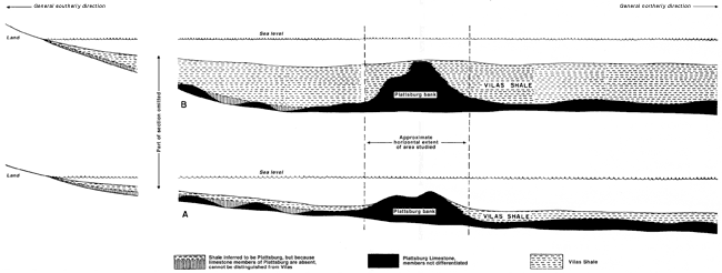
The Plattsburg Limestone (Lansing Group, Upper Pennsylvanian) anomalously thickens in the area near Neodesha and Fredonia, southeastern Kansas (Fig. 1), where it increases from an average of about 20 feet thick to a maximum of 115 feet. This study was undertaken to interpret the causes and the economic significance of this thickening. The Plattsburg Limestone was studied in outcrops in the eastern part of the Neodesha-Fredonia area and was traced by means of drillers logs in the western part of the area where it passes underground (Pl. 1A).
Figure 1--Index map showing location of Neodesha-Fredonia area and outcrop belt of combined Plattsburg Limestone and Vilas Shale.
The principal cause of thickening of the Plattsburg Limestone in the Neodesha-Fredonia area is interpreted to be deposition of an extensive, lens-shaped, submerged marine bank that rose above the general level of the surrounding sea floor. The shape of the marine bank is partly reflected by present thickness variations in the Plattsburg Limestone (Pl. 1A). A second but less important cause of thickness variations is structural warping during deposition, which permitted greater thicknesses to form over downwarped places and less over upwarped places.
Relatively large, abrupt increases in thickness of certain Pennsylvanian and lower Permian limestones in Kansas have been interpreted to be reef or bioherm deposits (O'Connor and Jewett, 1952; Hattin, 1957; Wilson, 1957; and Davis, 1959). The thickened Plattsburg Limestone in the Neodesha-Fredonia area is thought not to have generally attained the wave-resistant status of a true reef, nor strictly to have formed a bioherm. The term bank is used here as a general term merely to denote a submerged shallow area that rises above the adjacent sea floor; the term does not imply possession of an appreciable degree of wave resistance, as does the term reef, nor imply creation chiefly by organisms, as does the term bioherm. It is possible, however, that the Plattsburg bank at times attained some degree of wave resistance, and of course, organisms were important in its creation.
I wish to express my appreciation to Daniel F. Merriam of the State Geological Survey of Kansas, for his participation in part of the field work and for making numerous suggestions; to Herbert Mendoza of the University of Kansas, for making the acetate peels used in this study; and to Holly Wagner of the U. S. Geological Survey, for critically reading the manuscript and for making accessible to me his extensive collection of drillers logs in the Neodesha-Fredonia area.
I am also indebted to John Mark Jewett and Howard G. O'Connor, of the State Geological Survey of Kansas, for critically reading the manuscript. Thanks are due also to Cecil M. Taylor, of Stanford University, for making photographic prints of the acetate peels; to Mrs. Dorothy Lloyd, of Stanford University, for typing the manuscript; and to John Davis of the University of Kansas, who accompanied me at various times in the field.
The abnormal thickness of the Plattsburg Limestone near Neodesha was first noted by Newell (1933) in connection with reconnaissance mapping and stratigraphic studies in southeast Kansas. Newell's mapping has been incorporated in the Geologic Map of Kansas (Moore and Landes, 1937), but his measured stratigraphic sections remain unpublished. Many of Newell's measured sections were used in selecting outcrops for redescription and remeasurement in this study. After Newell's studies, very little geological work leading to publication was done in Wilson and Montgomery Counties until the mid-1940's, when the Kansas State Highway Department began to conduct engineering geological studies in connection with highway construction programs. As a result of this work, one brief article was published (Chelikowsky and Burgat, 1947) describing thickness variations of units within the Lansing Group between Altoona and Fredonia. In addition, a considerable volume of unpublished engineering geological information has been accumulated by the State Highway Department, although most of the information does not bear directly upon this study.
In 1953, Wagner and Harris published a summary of stratigraphic studies in the Fredonia quadrangle, providing improved descriptions of the Plattsburg and Vilas formations as well as of other rocks of the region. In 1954, Wagner's geologic map of the Fredonia quadrangle was published, showing that the Plattsburg Limestone is exposed in the southeast corner of the Fredonia quadrangle, extending its known outcrop area slightly farther northwest.
In 1957 Wilson published the results of a brief study of the Stanton Limestone in western Montgomery County, southwest of Neodesha. Wilson interpreted thickened portions of limestone members of the Stanton as barrier reefs, although it seems that they are similar to the thickened Plattsburg Limestone in the Neodesha-Fredonia area and are not necessarily true reefs. In 1959, Davis concluded that the thickened portions of the Plattsburg Limestone exposed near Neodesha are mainly reef deposits, an interpretation with which the present author is not wholly in agreement.
This study was conducted in a rectangular area that includes slightly more than half of Wilson County and about one tenth of Montgomery County (Fig. 1). Studies in the eastern part of the area have consisted principally of description, measurement, and sampling of nineteen outcrop, sections of the Plattsburg Limestone. In addition, the thickness of the Vilas Shale was measured at localities where both it and the Plattsburg Limestone are exposed. In the rest of the area, where neither the Plattsburg Limestone nor the Vilas Shale is exposed, their thicknesses were studied by examination of drillers logs. Thickness data from approximately 200 drillers logs were selected for incorporation in the isopachous maps of the Plattsburg (Pl. 1A) and of the Vilas (Pl. 1B). Individual drillers logs are subject to appreciable error, and some of the logs examined were rejected because of uncertainty as to their reliability.
Good outcrops are scarce within the area, necessitating the examination of roadcuts, quarries, and stream banks in the search for the best exposures. The locations of outcrop sections described and measured are given in the appendix; eleven are in roadcuts, four are in quarries, and four are along stream banks. The quarry and stream-bank exposures are generally good, whereas the roadcut exposures range from excellent to poor.
In field work, hand leveling was used to measure vertical distances. About 200 limestone samples were collected, generally at intervals of 4 to 6 feet or where important lithologic changes occur. Many of the specimens were oriented by marking top and north directions on them before they were removed from the outcrop, permitting them to be re-oriented later in the laboratory.
Laboratory work has consisted of examination of 150 acetate peels of limestone specimens of the Spring Hill member. The peels have yielded much information about the types and proportions of rock-forming organisms, and have assisted in establishing lithologic subdivisions of the Spring Hill member.
Acetate peels reproduce microscopic details of limestones with remarkable fidelity. The acetate peels of this study were made as follows. Each oriented specimen was sawed along a vertical north-south plane and on a horizontal plane. Non-oriented specimens were merely sawed in a convenient direction. The sawed surfaces were polished and then etched by immersing them in dilute hydrochloric acid for a fraction of a minute. The acid reacts on various limestone particles at different rates, some particles being more readily attacked than others. The acid etches out the details of the rock in fine relief, and these details are in turn transferred to an acetate peel. The peel is made by pressing the rock surface against a sheet of draftsman's acetate that has been softened with acetone. The acetate sheet hardens in a few hours after evaporation of the acetone and may be peeled away from the rock surface. The acetate peels have been protected by sealing them between 3 1/4 x 4-inch lantern-slide cover-glass plates.
Peels, as contrasted with ordinary-sized thin-sections, allow larger rock surface areas to be studied. Most of the peels used in this study were about 2 1/2 by 3 1/2 inches in area. The peels were either viewed directly or were used to make enlarged negative photographic prints. The negative photographic prints were made by projecting the peels in a standard photographic enlarger onto high-contrast photographic printing paper, such as Kodabromide F-5. The enlarger lens aperture was stopped down to about f/11 to give sufficient depth of field to insure sharp, focus. Negative peel prints produced in this way have proved more convenient to use than peels themselves because the prints provide several magnifications and several prints may be easily viewed and compared simultaneously. Peel prints shown in this report are reproduced at a magnification of 1 3/4. [Note: images are enlarged for use on the web and magnifications have been recalculated.]
Comparison of peel prints of both vertically and horizontally oriented surfaces has proved useful in studying specimens containing algal crusts. The crusts, which tend to lie horizontal, appear somewhat different in horizontal surfaces as compared with vertical surfaces (Pl. 6, 7, 8, 10).
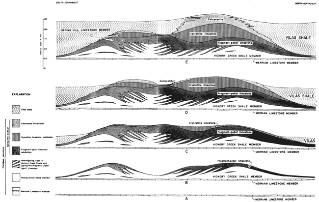
The lithologic subdivisions of the Spring Hill Limestone member, whose recognition at measured sections has been aided by acetate peels, are shown in a correlation cross section (Pl. 2) and in a fence diagram (Pl. 3). The section and the diagram attempt to portray the structure of the divisions of the Plattsburg and of the Vilas Shale in the eastern part of the Neodesha-Fredonia area at the end of deposition of the Vilas Shale and before regional tilting occurred. Both the section and the fence diagram employ the contact between the Vilas Shale and Captain Creek Limestone member (of the Stanton Limestone) as the horizontal datum. Assuming that beds adjacent to the contact were deposited nearly horizontal, the structure of the underlying Plattsburg shown in the section and diagram should approximate that which existed at the end of Vilas deposition. At some of the outcrop localities included in the fence diagram (Pl. 3), the Vilas Shale and Captain Creek Limestone member are absent because of recent erosion. In such areas, the base of the Merriam Limestone member (Plattsburg) has been substituted as a horizontal datum, the thickness interval between the base of the Merriam member and the Vilas-Captain Creek contact being assumed to be about the same over much of the eastern part of the area.
The Plattsburg Limestone is included within the Lansing Group, which in turn is included within the Missourian Stage of the Upper Pennsylvanian. The sequence of groups into which the Missourian Stage is divided and the divisions of the Lansing Group are summarized in the following table:
Table 1--Groups composing the Missourian Stage, with list of formations and members in Lansing Group.
The Plattsburg Limestone, named by Broadhead (1866, p. 317) from outcrops in northwestern Missouri, overlies the Bonner Springs Shale of the Kansas City Group, and underlies the Vilas Shale, the Plattsburg is identified in southeastern Nebraska, and has been traced from south-central Iowa across northwestern Missouri and eastern Kansas to the Oklahoma boundary. It becomes discontinuous near the Oklahoma boundary, but it seemingly reappears farther south and is represented in the upper part of the Ochelata Group of Oklahoma (Moore and others, 1951, p. 80). Its thickness varies from place to place and its average thickness in Kansas has been stated by Moore (1949, p. 115) to be about 20 feet. Its thickness is known to range from 6 to 115 feet in the Neodesha-Fredonia area. The Plattsburg Limestone is divided into three members, which are described in ascending order below.
The Merriam Limestone is the lowermost member of the Plattsburg Limestone. In the Neodesha-Fredonia area, the Merriam Limestone member generally consists of a single dense limestone bed, 1 to 3 feet thick, which contains abundant sponges Heliospongia and Girtyocoelia. North of the area, the thickness range is greater and thicknesses of as much as 10 feet occur (Moore and others, 1951, p. 81).
The Hickory Creek Shale is the middle member of the Plattsburg Limestone. In the Neodesha-Fredonia area, the Hickory Creek Shale member consists of gray to yellowish-gray calcareous clay shale, which contains extremely abundant crinoid stem discs and fragments of bryozoans and of the sponges Heliospongia and Girtyocoelia. Its thickness ranges from 1 to 45 feet in the area, although the thickness range is much less elsewhere in Kansas. Where it is thick in the area, limestone beds are common and in places are incorporated in large-scale cross beds that dip as much as 7° (Pl. 3, 4B). Individual limestone beds vary greatly in thickness from place to place and are composed of fragmental limestone resembling fragment-pellet type limestone in the lower lithologic subdivision of the overlying Spring Hill Limestone member. The boundary between the Hickory Creek and Spring Hill members is marked by a general upward transition from shale to limestone, but the presence of limestone in the Hickory Creek member makes establishment of the boundary arbitrary in places. Where large crossbeds occur, the Hickory Creek and Spring Hill members seem to interfinger, adding to the difficulties of establishing an exact boundary.
Plate 4--Crossbedded Hickory Creek Shale member in shale pit at brick plant (Loc. 17, SW sec. 7, T. 31 S., R. 16 E.). Thick Hickory Creek Shale member containing many limestone beds. A. Strike section showing lenticular limestone beds in shale. Wavy-bedded limestone at top of cliff is relatively thin Spring Hill member. Wall of pit is about 60 feet high. B. Dip section showing 7° dip of shale and limestone beds. Dipping beds interpreted to have been deposited on sloping sides of bank. Rock exposure is about 40 feet high.
The Spring Hill Limestone is the uppermost member of the Plattsburg Limestone, overlying the Hickory Creek Shale member and underlying the Vilas Shale. In the Neodesha-Fredonia area, the Spring Hill member ranges from 3 to 88 feet in thickness. Elsewhere in Kansas its thickness is variable, but its maximum thickness is less. The Spring Hill member may be subdivided in places where exposed in the Neodesha-Fredonia area into three tabular masses of contrasting lithology, which occur in regular vertical sequence and which may be traced laterally and correlated (Pl. 2, 3). The lithologic subdivisions are, in ascending order, (1) fragment-pellet limestone subdivision, (2) crystalline limestone subdivision, and (3) calcarenite subdivision. The subdivisions are intergradational, making it difficult to establish precise boundaries between them.
Limestone that has been termed fragment-pellet limestone makes up the lowest subdivision of the Spring Hill member in the Neodesha-Fredonia area, forming a tabular mass, which ranges from about 3 to 35 feet in thickness. The limestone is composed chiefly of fragments of calcareous algae and of invertebrate fossils, and also contains numerous irregular small pellets. Plate 5 exhibits its typical peel-print appearance. Fossil fragments include crinoid stem discs, bryozoans, the sponges Girtyocoelia and Heliospongia, mollusks, and brachiopods. The bulk of the rock, however, is composed of very irregular particles or fragments that are thought to be derived from calcareous algae. These particles impart a distinctive mottled appearance, which permits the rock to be easily distinguished in peels from other limestone types in the Spring Hill member. The algae presumed to have supplied the particles have not been identified. The algal particles generally make up half or more of the rock, and the rest is composed of fragments of invertebrate fossils, of pellets, and of fine matrix.
Plate 5--[Note: images enlarged for web display and magnifications recalculated.] Fragment-pellet limestone (Spring Hill member). Negative peel prints, all x2.3. A. Vertical surface of Spec. 174 showing sponges. Arrow points to top of bed. (Loc. 15, S. line SW sec. 34, T. 30 S., R. 15 E.) B. Vertical surface of Spec. 126 illustrating fragment-pellet limestone. Arrow points to top of bed. (Loc. 18, SW NW sec. 24, T. 31 S., R. 15 E.) C. Horizontal surface of Spec. 126 revealing partial fine recrystallization.
The pellets are not sharply distinguished from algal particles, except that the pellets are smaller, generally ranging from about 1/4 to 3/4 mm in maximum dimension, and are more rounded or oval in shape than larger particles. The pellets are composed of fine material and lack concentric layers and radial fibers that ooliths commonly possess. It is suspected that the pellets are also of algal origin, perhaps being derived from the same general source as the larger algal particles, but it is also possible that some represent lithified fecal pellets, which occur in many Paleozoic and younger limestones.
Fragment-pellet limestone is not generally visibly crystalline, contrasting strongly in this respect with the conspicuously crystalline limestone of the middle subdivision of the Spring Hill member. Large pores and crystal-lined vugs, which occur generally in the crystalline limestone, are likewise uncommon in fragment-pellet limestone.
Limestone of the fragment-pellet subdivision seems to be distributed throughout most of the Neodesha-Fredonia area and it forms the entire sequence of the Spring Hill where the member is thin, although forming only the lower part where the member is thicker.
The middle lithologic subdivision of the Spring Hill member has been termed the crystalline limestone subdivision because of the presence of conspicuous quantities of visibly crystalline calcite. Much of the crystalline calcite is closely associated with encrusting forms of calcareous algae, either surrounding algal fragments or occurring within the algal material itself. In addition to algae, invertebrate fossils including brachiopods, mollusks, bryozoans, and crinoids have contributed much fragmental material to the rock. Irregular thin laminae of gray shale are commonly intercalated in the limestone. The crystalline limestone subdivision ranges from a featheredge to about 45 feet thick, although the gradational nature of boundaries between it and underlying and overlying lithologic subdivisions make establishment of its thickness partly arbitrary in places. The extent and approximate thickness of the crystalline limestone subdivision in the eastern part of the Neodesha-Fredonia area are shown in the fence diagram (Pl. 3).
Two principal growth forms of encrusting calcareous algae are common in the crystalline limestone subdivision: (1) algae represented by encrusted thin blades or fronds, which are believed to have been derived through disintegration of upright-growing algal forms, and (2) encrusting forms that grew prostrate on the sea floor and that are preserved essentially in the position of growth.
It is probable that several algal forms are shown in limestone peel prints reproduced in Plates 6 to 9. The forms may be rudely classified according to thickness. Plate 6 shows a form whose fragments average about 0.15 mm thick and which seems to be distinct from the forms shown in Plates 7 and 8, whose fragments average about 0.7 mm thick. The thicker fragments show some resemblance to the alga Anchicodium, which has been identified in certain Pennsylvanian limestones in Kansas by Johnson (1946, p. 1112), although no algae have been identified generically in this study. The name "Marksia", however, has been informally applied in the field to some of the elongate algal fragments because of their resemblance on a weathered surface to pencil marks.
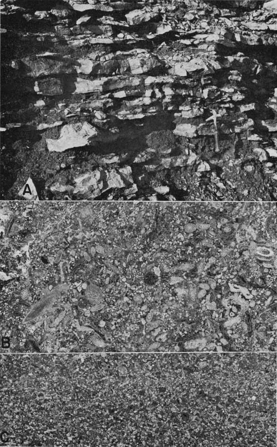
Plate 6--[Note: images enlarged for web display and magnifications recalculated.] Thin algal crusts (Spring Hill member). Limestone containing abundant fragments of encrusted calcareous algae, which appear as irregularly wavy thin crusts averaging about 0.15 mm thick. Crust fragments are thought to be derived from leaf-like blades of upright-growing algal forms. Fragments of bryozoans also present. Totally dark spots are pore spaces, many surrounded by visibly crystalline calcite. Negative peel prints, x2.3; Spec. 243. (Loc. 12, W2 NE sec. 15, T. 30 S., R. 15 E.) A. Vertical surface showing layered effect produced by accumulation of encrusted blades; arrow points to top of bed. B. Horizontal surface of same specimen showing irregular surface of blades.
Plate 7--[Note: images enlarged for web display and magnifications recalculated.] Algal crusts (Spring Hill member). Limestone contains abundant fragments of encrusted calcareous algae, which appear as irregular blades averaging about 0.7 mm thick. This algal form seems closely related to that shown on Plate 6 except for greater thickness. Crust fragments thought to be portions of leaf-like blades from an upright-growing algal form. Some rounded particles are thought to be small fragments of abrasion-rounded crusts. Dark patches are pores, many surrounded by visibly crystalline calcite. Negative peel prints, x2.3 (Loc. 14, S line SE SW sec. 23, T. 30 S., R. 15 E.) A. Vertical surface of Spec. 33; arrow points to top of bed. B. Horizontal surface of Spec. 32.
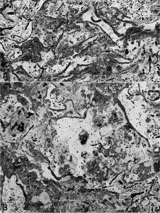
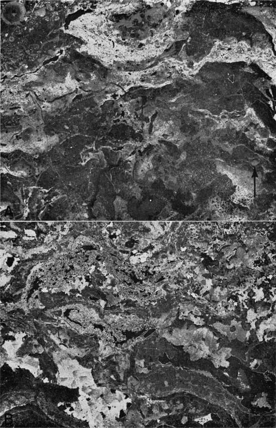
Plate 8--[Note: images enlarged for web display and magnifications recalculated.] Algal crusts surrounded by crystalline calcite (Spring Hill member). Limestone contains abundant fragments of encrusted algal blades. Part of space between blade fragments occupied by crystalline calcite (dark) similar in appearance to crystalline calcite composing blades themselves. Rest of space is filled with lithified fine limy mud (light-appearing) not visibly crystalline. Some of crystalline calcite between algal blades may represent open-space precipitation of calcite. Blade fragments interpreted to have been detached from upright-growing algal forms. Accumulated blade fragments may have formed porous mat sufficiently rigid to maintain open spaces and serve as filter trap for fine sediment. Negative peel prints, x2.3; Spec. 129. (Loc. 18, SW NW sec. 24, T. 31 S., R. 15 E.) A. Vertical surface; arrow points to top of bed. B. Horizontal surface.
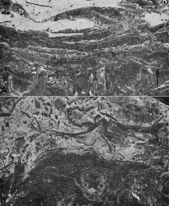
Plate 9--[Note: images enlarged for web display and magnifications recalculated.] Algal crusts surrounded by coarsely crystalline calcite (Spring Hill member). Coarsely crystalline limestone thought to have formed chiefly by precipitation of calcite in open spaces between algal crusts. Algal crusts now only faintly discernible. Totally dark patches are pore spaces, which may in part represent unfilled original space between crusts, or which may have been developed through later re-solution of calcite. Negative peel prints; x2.3. (Loc. 14, S. line SE SW sec. 23, T. 30 S., R. 15 E.) A. Vertical surface of Spec. 35. Note cross sections of several brachiopod shells and fenestrate bryozoan fronds that are not visibly crystalline. B. Horizontal surface of Spec. 36 showing abundant pore space.
Examples of calcareous algae that are believed to have been preserved essentially in position of growth are shown in Plate 10. These algae have been informally termed "cauliflower crusts" because of their rude similarity to the surface of a cauliflower head. A well-preserved example is shown in Plate 1OA; it consists of small, irregularly lumpy, finely laminated crusts. A poorly preserved example, which is believed to represent recrystallized material, is shown in Plate 10 B, C. Only the gross outlines have been preserved in the recrystallized material; the laminae and any other internal details have been obliterated, although fragmental debris derived from invertebrate fossils and pelletal material have escaped recrystallization. It is not known whether the well-preserved example (Pl. 10A) represents the same form as the recrystallized example (Pl. 10 B, C), but the gross outlines of the two forms are similar, suggesting that they may be related. It is probable that the cauliflower-shaped crusts represent simple colonial forms of algae similar to several genera that have been identified in Pennsylvanian limestones in Kansas and Colorado (Johnson, 1940, 1946).
Plate 10--[Note: images enlarged for web display and magnifications recalculated.] Cauliflower algal crusts (Spring Hill member). Crusts are thought to be preserved in position of growth. Negative peel prints; x2.3. A. Crusts that have escaped recrystallization and in which growth laminae are preserved. Spec. 151, from SW cor. sec. 5, T. 34 S., R. 15 E. B. Vertical surface of limestone in which only outlines of cauliflower-like crusts are preserved. Growth laminae, if originally present, have been obliterated by recrystallization. Not known whether form shown in 10 B, C represents same alga shown in 10 A. Numerous pellets and small abraded fragments fill spaces between cauliflower crusts and have escaped recrystallization. Spec. 38. (Loc. 14, S. line SE SW sec. 23, T. 30 S., R. 15 E.) C. Horizontal surface of Spec. 38. Large irregular patches represent parts thought to be second stage of recrystallization that has obliterated earlier-formed textures.
Much of the visibly crystalline calcite that surrounds encrusted algal fragments has been derived either through recrystallization of fine lime mud, or more probably through precipitation of calcium carbonate in open spaces between the algal fragments. It seems possible that the algal fragments may have created a loose mat as they accumulated, permitting fine material to filter down to fill the spaces between fragments. Any space left unfilled, however, may have been filled later by precipitated crystalline calcite. Plates 6 to 9 show examples of limestone arranged in order of progressive increase in amount of crystalline calcite. Only a moderate part of the rocks shown in Plates 6 and 7 is visibly crystalline, whereas the examples shown in Plates 8 and 9 are in large part visibly crystalline. Evidence suggesting that a large part of the calcite shown in Plates 8 and 9 may represent open-space precipitation of calcite around algal fragments is found in the rude tendency for the long axes of calcite crystals to be oriented perpendicular to the surfaces of the algal fragments (central part of Pl. 8A). Crystals growing in open space outward from the walls of a pore or vug would tend to have long axes perpendicular to the surface. Wray (1959) has interpreted crystalline calcite surrounding algal fragments in certain Pennsylvanian bioherms of New Mexico to be open-space fillings, citing similar evidence. In addition, part of the visibly crystalline calcite in these examples is probably the result of solution of originally deposited material followed by redeposition of crystalline calcite in the open spaces created through solution. Where the volume of material redeposited is less than that removed in solution, considerable pore space may remain. Plates 6, 7, and 9 show good examples of intricate, small pore spaces (black-appearing), which are thought to represent in part space left through incomplete refilling of solution pores and vugs.
Appearance of limestone of the crystalline subdivision in quarry and stream-bank exposures is shown in Plates 11 and 12. Large pores and small elongate crystal-lined vugs are conspicuous, although some of the cavities that appear on the rock surfaces (Pl. 11C, 12) are not pores or vugs, but are due to removal of irregular shale laminae, which weather out readily.
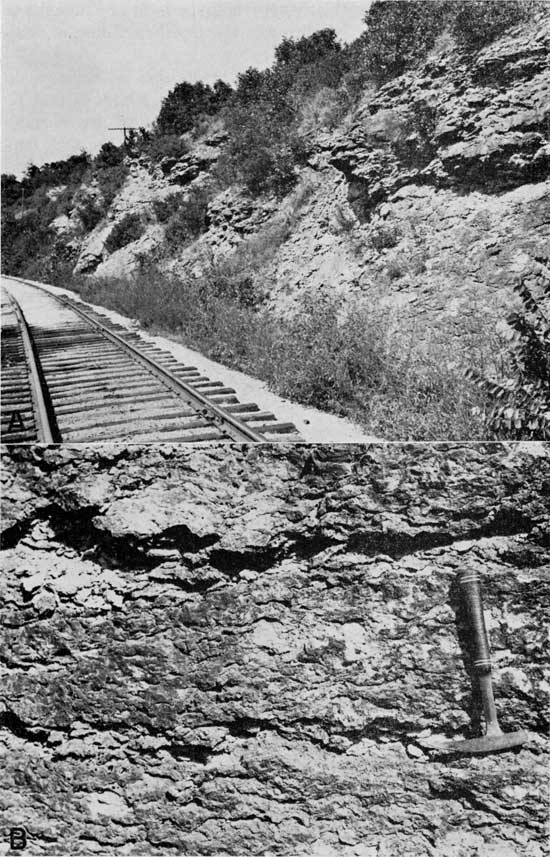
Plate 11--Quarries in Spring Hill member. A. Carr Quarry, 1 mile northwest of Neodesha, at which limestone from crystalline subdivision of Spring Hill member is extracted. (Loc. 13, NW sec. 18, T. 30 S., R. 16 E.) B. Quarry 3/4 mile northwest of Sycamore. Topmost few feet in quarry face consists of calcarenite, lower part is in crystalline limestone subdivision. (Loc. 18, SW NW sec. 24, T. 31 S., R. 15 E.) C. Close view of crystalline limestone shown in 11B. Contains abundant encrusting algae. Darker patches are light-brown coarsely crystalline calcite. Elongate, irregular open spaces represent both crystal-lined pore spaces and spaces left after shale partings have fallen out upon weathering.
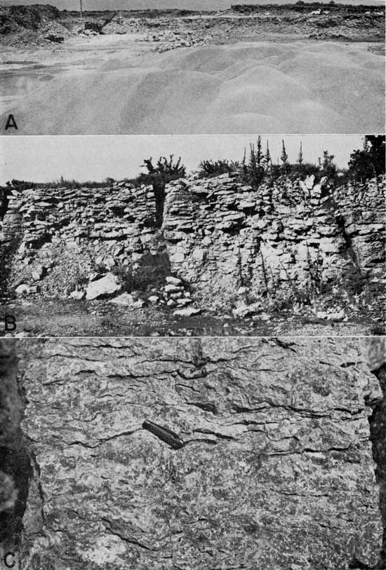
Plate 12--Weathered surface of crystalline subdivision of Spring Hill member. Rock is exposed in bluffs along Fall River adjacent to St. Louis-San Francisco railroad track (Loc. 10, SE SW sec. 30, T. 29 S., R. 15 E.) Rock contains abundant encrusting algae. Open spaces represent pore spaces as well as voids created where shale partings have fallen out. Bedding planes are obscure at this locality, although commonly obvious elsewhere. A. Broad view. B. Close view.
The upper lithologic division of the Spring Hill Limestone member has been termed the calcarenite subdivision because of the presence of bedded calcarenite. The calcarenite beds are cross-laminated in places, and commonly vary considerably in thickness in short horizontal distances. Equally variable beds of gray shale generally separate the calcarenite beds (Pl. 13A). The calcarenite subdivision ranges from a featheredge to about 35 feet thick (Pl. 2, 3).
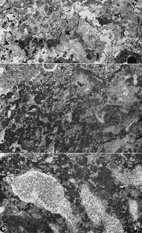
Plate 13---[Note: images enlarged for web display and magnifications recalculated.] Calcarenite of Spring Hill member. A. Thin calcarenite beds separated by irregular thin beds of gray, Vilas-type shale. B. Calcarenite in which particles are poorly to moderately rounded and sorted. Contains abundant fusulinids, shell fragments, crinoid stem discs, and irregular particles possibly derived from calcareous algae. Negative print; x2.3; Spec, 235. (Loc. 9, SW NW sec. 32, T. 29 S., R. 15 E.) C. Fine-grained calcarenite. Particles include subrounded fragments of fusulinids, crinoid stem discs, fenestrate bryozoan fronds, and ramose bryozoans. Negative peel print; x2.3; Spec. 44 (Loc. 13, NW sec. 18, T. 30 S., R. 16 E.)
The calcarenite is composed of bioclastic debris of varying degrees of coarseness, rounding, and sorting. Examples range from fine to coarse and are composed of poorly sorted, irregular grains to relatively well sorted, rounded grains (Pl. 13B, C). The grains consist of crinoid stem discs, fusulinids, algal (?) pellets, and fragments of bryozoans, brachiopods, gastropods, sponges, and calcareous algae. In some beds, the fragments are encrusted with the alga Osagia. Examples of calcarenite exhibiting a low degree of rounding and sorting show some resemblance to fragmental limestones of the fragment-pellet, or lower lithologic subdivision, but fusulinids are common in the upper subdivision and are absent in the lower subdivision.
Shale beds in the calcarenite subdivision are composed of clay shale similar to the Vilas Shale, and it is probable that they are thin tongues of Vilas Shale interfingering with the Spring Hill calcarenite beds. If this assumption is correct, the calcarenite beds are lateral facies equivalents of part of the Vilas Shale. It is probable that the crystalline limestone subdivision and the upper part of the fragment-pellet subdivision are facies equivalents of the Vilas Shale, because they also contain thin shale beds. Unfortunately, there are no broad lateral exposures that might permit tracing of the Vilas Shale into the Spring Hill member. The thickness relations of the Plattsburg Limestone and the Vilas Shale suggest, but do not prove, that the two formations are partial time equivalents of each other. Where the Plattsburg is thick, the Vilas tends to be thin and is as little as 2 feet thick. Where the Plattsburg is thin, the Vilas tends to be thick, attaining a maximum thickness of about 130 feet. These inverse thickness relations could be caused by lateral facies chances, an explanation offered by Chelikowsky and Burgat (1947) for thickness changes in the Plattsburg and Vilas west of Altoona. It is also conceivable, however, that thickness differences in the Vilas Shale are due solely to deposition over an irregular sea floor, thin parts forming over submarine topographic highs where thick Plattsburg deposits bad formed previously.
The Spring Hill member of the Plattsburg Limestone has been quarried at three localities within the area shown on Plate 1. The quarries, situated in localities where the Plattsburg Limestone is relatively thick, are listed below:
Thick parts of the Spring Hill Limestone member, which occur where the Plattsburg is relatively thick, should be suitable for quarrying at other localities in the Neodesha-Fredonia area. The isopachous map of the Plattsburg (Pl. 1A) reveals that the thickest parts of the Plattsburg Limestone occur in an area extending between Fredonia and Neodesha. Additional quarries might be located where the Plattsburg is exposed and accessible.
Although no oil is produced from the Plattsburg Limestone in the Neodesha-Fredonia area, the thickened Spring Hill member of the Plattsburg Limestone may provide an example of a large lensing porosity zone similar to certain porous zones in Pennsylvanian limestones that yield oil in central and western Kansas.
Conspicuous pores in the Spring Hill member are virtually confined to the crystalline limestone subdivision, where they occur in close association with light-brown and dark-yellow crystalline calcite (Pl. 11C). The fragment-pellet and calcarenite subdivisions contain much less visibly crystalline calcite and are of lower porosity. In general, the degree of porosity is related to the degree of crystallinity. Beds that contain large proportions of relatively coarsely crystalline calcite are the most porous; beds that contain small proportions have few visible pores.
The presence of coarsely crystalline limestone in the Spring Hill member has been shown to be closely related to the presence of various forms of encrusted calcareous algae. Thus, it is possible to show some relation between the degree of porosity and types of rock-forming organisms. Five limestone types from the Spring Hill member are arranged in order of decreasing porosity below:
Relations between porosity and types of rock-building algae suggest that oil-reservoir properties of Pennsylvanian limestones in central and western Kansas might be partly controlled by presence or absence of encrusting algae. It is conceivable that reservoir conditions might be predicted from limestone observed in well cuttings and cores.
On succeeding pages, an attempt is made to interpret the deposition of the Plattsburg Limestone in the Neodesha-Fredonia area. Interpretations made involve varying degrees of speculation, for it is generally difficult or impossible to interpret accurately the conditions under which ancient sedimentary deposits were formed. A series of hypothetical cross sections (Fig. 2) has been drawn to portray graphically the successive steps in the deposition of the thickened part of the Plattsburg Limestone, and to show the relations between the thickened Plattsburg Limestone and the Vilas Shale during deposition.
Figure 2--Series of hypothetical cross sections illustrating successive steps in development of Plattsburg bank in eastern portion of Neodesha-Fredonia area. Length of sections approximately 15 miles. Note large vertical exaggeration. A. Deposition of Merriam Limestone member. B. Deposition of Hickory Creek Shale member and lower part of fragment-pellet limestone subdivision of Spring Hill member. No sharp division between Hickory Creek Shale and Spring Hill Limestone members can be made, because beds of each member interfinger with the other. Overlapping dipping beds interpreted to have formed on sloping sides of irregularly lobate bank, creating opposing dips. C. Deposition of rest of fragment-pellet limestone and lower part of crystalline limestone subdivision of Spring Hill member. Vilas Shale interpreted as deposited adjacent to bank at greater depth, interfingering with Spring Hill member. D. Deposition of rest of crystalline limestone subdivision and lower part of calcarenite subdivision. Additional deposits of Vilas Shale encroach upon sloping sides of bank. E. Deposition of uppermost calcarenite beds and encroachment of Vilas Shale over bank. A larger version of this figure is available.
The Merriam Limestone member is not distinguished by abnormalities of thickness in the Neodesha-Fredonia area and ranges from about 1 to 3 feet thick. It is interpreted to have been deposited on a nearly horizontal sea floor (Fig. 2A), which probably undulated slightly, perhaps accounting for the small variations in thickness. Environmental conditions favored the growth of sponges, which are present in profusion in the limestone.
Deposition of the Hickory Creek Shale member represents a change from deposition of the more or less pure limestone of the Merriam member to deposition of calcareous muds and interbedded limestones (Fig. 2B). Despite the transition from clear to intermittently muddy sea-bottom conditions that this change suggests, the environment remained hospitable to sponges, as indicated by their abundance in the shale. Varying thicknesses of clay and mud accumulated from place to place, resulting in the accumulation of a thickened lens of mud that varied about twenty-fold in thickness, judging from present variations in thickness of the Hickory Creek member. From time to time, limestone beds of fragment-pellet lithology were intercalated with the mud.
The thickened lens of shale and limestone is interpreted to have been deposited as an irregular marine bank, which rose above the general level of the surrounding sea floor. Evidence suggesting this is provided by large-scale crossbeds, which at locality 17 (appendix; Pl. 2, 4B), dip about 7° southwest and strike northwest, and at locality 18, two miles southwest of locality 17, dip about 5° in the opposite direction, toward the northeast. The presence of large crossbeds implies the existence of differences in elevation during deposition, for the crossbeds must have accumulated on slopes inclined at least as steeply as the present inclination of the crossbeds relative to adjacent regular beds. Compaction after deposition would tend to cause the original dips to be decreased. The variable dip directions of the crossbeds suggest that they were greatly affected by topographic irregularities, such as lobed projections of the bank.
Some idea of the dimensions of the mud bank may be gained from the isopachous map of the total Plattsburg thickness (Pl. 1A), assuming that the thickness of the Hickory Creek member is roughly proportional to the thickness of the total Plattsburg (Pl. 2). The thickened portion of the Plattsburg extends in a northwest-southeast direction for about 14 miles and the width, measured in a northeast-southwest direction, is about 10 miles. The original southeastward extent of the thickened Plattsburg is unknown, erosion having truncated the Plattsburg in the eastern part of the area. Two other thickened portions of the Plattsburg occur in the area, one in T. 28 S., R. 15 E., and the other in T. 28 S., R. 13 E. (Pl. 1A). These may represent separate, smaller banks.
The conditions under which the mud bank was deposited may be speculated upon. It is possible that the bank consisted of a large number of overlapping deltaic deposits, which in the aggregate formed a northwest-trending delta complex. The source of clay and mud deposited in the bank is unknown, although these materials may have been derived from land areas that lay in a general southerly direction, suggested by the increasingly shaly composition of many Pennsylvanian deposits when traced southward into Oklahoma. On the other hand, the calcareous materials probably had a local source, as they consist in large part of fragments of lime-secreting organisms that probably lived near the sites of deposition.
Lime-secreting organisms may have served also as sediment-trapping and binding agents. Frond or stalk-like forms of bryozoans, crinoids, and sponges anchored to the top and sloping sides of the bank may have helped to stabilize the mud deposits and to permit them to accumulate on slopes at least as steep as 7°. It is possible that noncalcareous algae or other forms of sea weeds served as sediment-binding agents, although no direct evidence has been found to indicate that such plants lived on the bank. Modern marine mud banks in Florida Bay (Ginsburg, 1956) may be cited as examples of mound-shaped marine deposits stabilized by plants. Ginsburg and Lowenstam (1958) suggest that banks of soft limy mud now forming in the very shallow waters of Florida Bay are bound together by the marine grass Thalassia, which grows in abundance over the banks. Consequently, it seems possible that seaweed-like plants may have helped stabilize the Hickory Creek muds.Deposition of clay and silt forming the Hickory Creek member gradually gave way to deposition of predominantly calcareous material forming the fragment-pellet subdivision of the Spring Hill member. No sharp boundary between the Hickory Creek and Spring Hill members exists where the Plattsburg is thickened. Interlayered shales and limestones that exhibit large-scale crossbedding, although included within the Hickory Creek member, might also logically be placed in the Spring Hill member. The shale beds are of Hickory Creek lithology but the limestone beds are of Spring Hill (fragment-pellet) lithology.
Calcareous debris forming fragment-pellet limestone is thought to have been derived locally. Calcareous algae seem to have contributed the bulk of fragmental and pelletal debris, although sponges, crinoids, and other marine invertebrates also contributed significant volumes of material. It seems likely that the environment over the higher parts of the bank was especially favorable for growth of these organisms, perhaps owing to greater clarity of water or other factors associated with shallower depth. Calcareous debris was probably swept downward to accumulate on the slopes of the bank to form the limestones of the large-scale crossbeds (Pl. 4B).
As deposition of limestone over the bank continued, there was a gradual and poorly marked transition from calcareous deposits consisting predominantly of fragmental and pelletal material to deposits formed principally by encrusting calcareous algae (Fig. 2C, D) which are now partly crystalline. Both prostrate, laminar forms and erect, frond-like algal forms seem to have been present and both probably possessed sufficient stiffness to have served as bank-stabilizing agents by trapping and binding the loose sediment. Wray (1959) interprets certain algal bioherms or banks in the Upper Pennsylvanian of New Mexico as having been built up through the influence of a sediment-trapping baffle mechanism of leaf-like algal fronds of the calcareous algae Anchicodium and Ivanovia. A similar stabilizing mechanism is envisioned to have guided deposition of limestone portions of the Plattsburg bank, inasmuch as an alga showing some resemblance to Anchicodium is present in the crystalline limestone subdivision. Furthermore, it is likely that crinoids and bryozoans also exerted a sediment-binding and trapping effect. Growth of calcareous algae was probably greatly encouraged by the higher energy conditions associated with shallower water over the bank. Algae are dependent on sunlight as their primary source of energy, of course, and light intensity is greater in shallow water than in deep water. Consequently, it is probable that the rate of production of calcareous material over the bank was considerably greater than in deeper waters.
If the mass of calcareous material forming over the bank was built up into extremely shallow water and if the mass possessed sufficient coherence and rigidity to be strongly wave resistant, it may be regarded as a true reef. Evidence concerning its wave resistance is not clear. Fragments of calcareous algae and other organisms would not be expected to possess much wave resistance in themselves, but if firmly cemented together they might have formed a rigid mass. Prostrate-growing cauliflower-shaped encrusting algae that were not fragmented may have possessed considerable rigidity and been able to bind loose material together, imparting an appreciable degree of wave resistance.
The superior elevation over the bank may have had an additional important influence in allowing much more calcareous material to form over the bank than in deeper water. It is believed that mud represented by the Vilas Shale was deposited at greater depths around the bank at the same time that predominantly calcareous material was deposited over the bank. Support for this contention is found in the thin beds of gray shale that occur intermittently through the Spring Hill member. These beds are similar to Vilas Shale in lithology, and they may represent tongues that are laterally continuous with the Vilas (Fig. 2 C, D). If this interpretation is correct, it seems that depth was the ruling factor in governing whether clay mud or predominantly calcium carbonate was deposited. Perhaps turbid currents of suspended clay and silt moving along the sea floor were virtually confined to deeper places because of their greater density as compared with clear sea water, whereas conditions were favorable for production of calcareous material principally in shallow water. On the other hand it is conceivable that the entire Vilas Shale was deposited after the Spring Hill member had been deposited and does not interfinger.
The final step in development of the Plattsburg bank was deposition of calcarenite and interbedded shale (Pl. 13A) over the higher parts of the bank (Pl. 2, 3). The shale beds are of Vilas lithology, and it is believed that they represent tongues of the Vilas Shale that continued to be deposited adjacent to the bank (Fig. 2E). The calcarenite beds are composed of grains contributed by crinoids, fusulinids, bryozoans, brachiopods, and mollusks and show varying degrees of rounding and sorting. In some beds, the grains are encrusted with the alga Osagia, forming "osagites". The contributing organisms probably lived over the bank, and the granular material that they provided was deposited nearby, which is suggested by the localized occurrence of the calcarenite beds. Rounding and sorting of the grains, though indicating transportation by waves and currents, do not necessarily signify transportation over long distances. Lane (1958, p. 153) has estimated that osagite deposits have formed at depths of approximately 60 feet, comparing them with deposits containing encrusting algae forming on the Bahama banks. If Lane's estimate is correct, the top of the bank may have lain at depths of about 60 feet during deposition of the calcarenite subdivision.
Deposition of calcarenite and shale beds continued over the highest parts of the bank almost until the Captain Creek Limestone member of the Stanton Limestone was deposited. Bank development in the Neodesha-Fredonia area continued, however, with development of three successive thickened limestone lenses in the Stanton Limestone, which are probably similar to the Plattsburg bank in origin. The first is in the Captain Creek Limestone (lower member of the Stanton Limestone) about 7 miles southwest of the Plattsburg bank, the second is in the Stoner Limestone (middle member of the Stanton) about 12 miles southwest, and the third is in the South Bend Limestone (uppermost member of the Stanton) about 15 miles southwest. These thickened limestones have been interpreted by Wilson (1957) as barrier reefs, but it is questionable whether they possessed sufficient wave resistance to be classed as true reefs. Thus, it seems that four successive banks were formed, each lying farther southwestward than the preceding bank.
The significance of the thickened Plattsburg Limestone in the Neodesha-Fredonia area could be best understood if the relations of the Plattsburg and Vilas formations were better understood over large distances. South of the Neodesha-Fredonia area, the Plattsburg is discontinuous and seems to undergo important facies changes and locally is oolitic southwest of Independence, Kansas. North of the area, the Plattsburg is continuous but exhibits changes in thickness and lithology from place to place that have not been critically studied everywhere.
Figure 3 is a series of two hypothetical cross sections, one of which shows the regional setting of the Plattsburg bank during deposition, and the other soon after the close of deposition. No horizontal dimensions are shown, because of inadequate knowledge, nor is the precise direction of the cross sections indicated. The general increase in proportions of shale and sandstone in Pennsylvanian rocks southward suggests that a land area existed in a general southerly direction and may have served as a local source of clay and silt incorporated in the Plattsburg and Vilas formations. The Plattsburg bank of the Neodesha-Fredonia area may be only one of a series or chain of irregular banks that formed north of the land area. The banks may have been analogous to barrier reefs, in that they lay between the land area to the south and the shallow, open sea to the north, but they were probably ineffective barriers because they were not laterally continuous (Pl. 1A), permitting land-derived clay and silt to be transported past them and to be deposited on the seaward (northerly) side as well.
Figure 3--Hypothetical cross sections illustrating regional setting of Plattsburg bank during deposition. Horizontal dimensions are purposely omitted because of insufficient knowledge. Deposits equivalent to Plattsburg south of bank consist partly of shale, as limestone layers pinch out. Presence of land area to south is conjectural, but is suggested by general increase in proportion of shale in upper Pennsylvanian rocks toward south. A. Bank during deposition of middle part of Spring Hill member, showing contemporaneous deposition of Vilas Shale. B. End of deposition of bank followed by complete encroachment by Vilas Shale. A larger version of this figure is available.
The Plattsburg bank persisted above the general level of the sea floor (Fig. 3A) almost until the close of Plattsburg-Vilas deposition, when additional deposits of clay and silt engulfed the bank, creating a nearly level sea floor (Fig. 3B). As the Plattsburg-Vilas sequence was formed, either sea level rose or the region subsided, permitting deposition to be more or less continuous. Studies of the cyclic succession of many Pennsylvanian deposits in eastern Kansas indicate that the shallow Pennsylvanian seas that extended over the midcontinent region fluctuated in depth, and it is likely that depth varied during deposition of the Plattsburg-Vilas sequence (Moore, 1949, p. 78, 144).
Van Siclen (1958) has shown that late Pennsylvanian and early Permian deposits in western and central Texas may be interpreted in terms of topography of the sea floor during deposition; he recognizes deposits formed on shallow submarine shelves, on slopes, and on deeper level portions that lay below wave base. He has shown that in various places limestones that formed on shallow shelves were expanded upward on their seaward edges to form reefs or other calcareous topographic prominences (banks). These reefs or banks lay seaward from land areas, and the intervening submerged areas were lagoon-like. Van Siclen has envisioned a typical depositional cycle governed by a period of rising sea level as follows: During the initial stages of a rise in sea level, organic limestones accumulated on a submerged coastal plain or shelf unhindered by arrival of much clay and sand. When drainage on land began to supply more terrestrial material, a new series of land-derived deposits was built out over the old drowned shelf, gradually restricting the area of limestone accumulation and ultimately covering it.
Van Siclen's concepts may be applied with some reservations to the Plattsburg-Vilas sequence. The thickened Plattsburg generally corresponds to his barrier reef or bank, and the Vilas shale corresponds to the series of land-derived deposits that gradually engulfed the limestone accumulation.
Locality number
1. NW SW sec. 8, T. 28 S., R. 17 E., Wilson County. Low creek bank exposes Merriam, Hickory Creek, and Spring Hill.
2. Center sec. 33, T. 29 S., R. 16 E., Wilson County. Shale quarry at Buffville brick plant. Excellent exposures of Merriam, Hickory Creek, and Spring Hill.
3. NW sec. 18, T. 29 S., R. 16 E., Wilson County. Deep road cuts along Highway 47 provide good exposures of Merriam, Hickory Creek, Spring Hill, Vilas, and Captain Creek.
4. NW SW sec. 17, T. 29 S., R. 16 E., Wilson County. Eroded hillside provides poor to fair exposures of Spring Hill, Vilas, and Captain Creek.
5. West line NW sec. 14, T. 29 S., R. 15 E., Wilson County. Shallow cuts along county road provide poor exposures of Merriam, Hickory Creek, Spring Hill, Vilas, and Captain Creek.
6. South line SW SE sec. 24, T. 29 S., R. 15 E., Wilson County. Surface of county road provides poor exposures of Spring Hill, Vilas, and Captain Creek.
7. NE NW sec. 2, T. 30 S., R. 15 E., Wilson County. Ditches along county road provide poor exposures of Spring Hill, Vilas, and Captain Creek.
8. NW NE sec. 3, T. 30 S., R. 15 E., Wilson County. Ditches along county road provide good exposures of Merriam, Hickory Creek, Spring Hill, Vilas, and Captain Creek.
9. SW NW sec. 32, T. 29 S., R. 15 E., Wilson County. Bluff on north side of Fall River provides excellent exposures of upper part of Spring Hill. Vilas and Captain Creek poorly exposed.
10. SE SW sec. 30, T. 29 S., R. 15 E., Wilson County. Bluffs along east side of Fall River and railroad cuts provide excellent exposures of upper part of Spring Hill. Vilas and Captain Creek poorly exposed.
11. SW NW sec. 10, T. 30 S., R. 15 E., Wilson County. Eroded hillside adjacent to county road provides poor to good exposures of Hickory Creek, Spring Hill, and Vilas.
12. W2 NE sec. 15, T. 30 S., R., 15 E., Wilson County. Surface and ditches of county road provide poor exposures of Spring Hill, Vilas, and Captain Creek.
13. NW sec. 18, T. 30 S., R. 16 E., Wilson County. Carr limestone quarry provides excellent exposures of upper part of Spring Hill and of Vilas and Captain Creek. Merriam and Hickory Creek poorly exposed.
14. South line SE SW sec. 23, T. 30 S., R. 15 E., Wilson County. Deep cuts along Highway 96 provide excellent exposures of Spring Hill, Vilas, and Captain Creek. Merriam and Hickory Creek moderately well exposed on adjacent eroded hillside.
15. South line SW sec. 34, T. 30 S., R. 15 E., Wilson County. Creek bank provides fair exposures of Merriam and part of Hickory Creek. Surface of county road provides poor exposures of rest of Hickory Creek and of Spring Hill.
16. NE SW sec. 4, T. 31 S., R. 15 E., Montgomery County. Creek bank provides poor and probably incomplete exposure of Spring Hill.
17. SW sec. 7, T. 31 S., R. 16 E., Montgomery County. Shale quarry at Brickton brick plant provides excellent exposures of Merriam, Hickory Creek, and Spring Hill.
18. SW NW sec. 24, T. 31 S., R. 15 E., Montgomery County. Quarry provides excellent exposures of Merriam, Hickory Creek, and Spring Hill.
19. South line SE sec. 16, T. 31 S., R. 15 E., Montgomery County. Surface and ditches of county road provide poor exposures of Merriam, Hickory Creek, Spring Hill, Vilas, and Captain Creek.
Broadhead, G. C. (1866.) Coal measures in Missouri: St. Louis Acad. Sci. Trans., v. 2, p. 311-333.
Chelikowsky, J. R., and Burgat, V. (1947) Structures and convergence of the formations in the Lansing group, Wilson County, Kansas: Kansas Acad. Sci., Trans., v. 50, p. 89-96.
Davis, J. C. (1959) Reef structure in the Plattsburg and Vilas Formations (Missourian) in southeast Kansas: Compass (Sigma Gamma Epsilon), v. 36, p. 319-335.
Ginsburg, R. N. (1956) Environmental relationships of grain-size and constituent particles in some south Florida carbonate sediments: Am. Assoc. Petroleum Geologists, Bull., v. 40, p. 2384-2427.
Ginsburg, R. N., and Lowenstam, H. A. (1958) The influence of marine bottom communities on the depositional environments of sediments: Jour. Geology, v. 66, p. 310-318.
Hattin, D. E. (1957) Depositional environment of the Wreford megacyclothem (Lower Permian) of Kansas: Kansas Geol. Survey, Bull. 124, p. 124-150. [available online]
Johnson, J. H. (1940) Lime-secreting algae and algal limestones from the Pennsylvanian of central Colorado: Geol. Soc. America, Bull., v. 51, p. 571-596.
Johnson, J. H. (1946) Lime-secreting algae from the Pennsylvanian and Permian of Kansas: Geol. Soc. Amer., Bull., v. 57, p. 1087-1120.
Lane, N. G. (1958) Environment of deposition of the Grenola Limestone (Lower Permian) in southern Kansas: Kansas Geol. Survey Bull. 130, pt. 3, p. 117-164. [available online]
Moore, R. C. (1949) Divisions of the Pennsylvanian System in Kansas: Kansas Geol. Survey, Bull. 83, 203 p. [available online]
Moore, R. C., and Landes, K. K. (1937) Geologic map of Kansas: Kansas Geol. Survey.
Moore, R. C., and others (1951) The Kansas rock column: Kansas Geol. Survey, Bull. 89, 132 p. [available online]
Newell, N. D. (1933) The stratigraphy and paleontology of the upper part of the Missouri Series in eastern Kansas: Unpublished Ph. D. dissertation, Yale University.
O'Connor, H. G., and Jewett, J. M. (1952) The Red Eagle Formation in Kansas: Kansas Geol. Survey, Bull. 96, pt. 8, p. 329-362. [available online]
Van Siclen, D. C. (1958) Depositional topography--examples and theory: Am. Assoc. Petroleum Geologists, Bull., v. 42, p. 1897-1913.
Wagner, H. C. (1954) Geology of the Fredonia quadrangle, Kansas: U. S. Geol. Survey Geol., Quad. Map 49.
Wagner, H. C., and Harris, L. D. (1953) Stratigraphy of outcropping Pennsylvanian rocks of the Fredonia quadrangle, Kansas: U. S. Geol. Survey, Oil and Gas Invest. Chart 48.
Wilson, F. W. (1957) Barrier reefs of the Stanton formation (Missourian) in southeast Kansas: Kansas Acad. Sci., Trans., v. 60, p. 429-436.
Wray, J. L. (1959) Origin of some Pennsylvanian algal bioherms in southwestern United States (abstract): Program, 1959 Nat. Conv., Am. Assoc. Petroleum Geologists, Dallas, p. 80-81.
Kansas Geological Survey, Marine Bank Development in Plattsburg Limestone
Placed on web Feb. 23, 2009; originally published in Dec. 1959.
Comments to webadmin@kgs.ku.edu
The URL for this page is http://www.kgs.ku.edu/Publications/Bulletins/134_8/index.html