![]()
Prev Page--Stratigraphy, Buried Rocks || Next Page--Stratigraphy, Permian
Stratigraphy, continued
Exposed Rocks
The Paleozoic rocks exposed in Cowley County fall into three natural divisions if we classify them according to their lithology and their topographic expression. The lower division is composed of beds of shale and shaly limestone about 335 feet thick, the middle division is composed of alternately bedded thick limestone and shale more than 600 feet thick, and the upper division is composed of soft shale beds 80 feet thick. As described under "Surface features," the rocks of the lower division form grass-covered steep slopes in the east face of the Flint Hills, those of the middle division form rock "steps" or terraces ascending westward, and those of the upper division form an almost level plain in the westernmost part of the county. The beds have not been grouped on this basis, however, but they have been described for the most part under more or less arbitrary divisions defined and named by early workers in central Kansas and now well established. There are four of these divisions--the Wabaunsee group, of Pennsylvanian age, including eight formations, and the Council Grove, Chase and Sumner groups, of Permian age, including a total of eleven formations. The lowermost of the three natural divisions mentioned above comprises the lowermost four formations of the Wabaunsee group; the middle natural division comprises the uppermost four formations of the Wabaunsee group, the Council Grove and Chase groups, and the lowermost two formations of the Sumner group; and the uppermost natural division is made up of the uppermost formation of the Sumner group, only the lower part of which is present in the county.
| Geologic Formations Exposed in Cowley County, Kansas The United States Geological Survey classes Permian and Pennsylvanian as series in the "Carboniferous System." |
|||||
|---|---|---|---|---|---|
| System | Series | Group | Formation and member | Thickness in feet |
Character |
| Quarternary | Recent | Alluvium and dune sand | 0-55± | Stream deposits of sand, gravel, and clay beds. | |
| 0-50± | Wind-blown sand in southwestern part of county. | ||||
| Pleistocene | Gravel and loess | 0-10± | Chert-gravel terraces chiefly bordering the Walnut and its tributaries 10 to 100 feet above stream beds. | ||
| 0-30+ | Wind-blown fine-grained reddish-brown material mantling surface in southwestern part of county. | ||||
| Tertiary (?) | Pliocene (?) | Gravel | 0-20 | Chert-gravel terraces 150 to 225 feet above streams. | |
| Permian | Sumner | Wellington formation | 80+ | Varicolored clay shale containing a few thin beds of gypsiferous limestone (lowermost 80 feet exposed). | |
| Herington limestone | 30 | Light buff limestone and dolomite. | |||
| Enterprise shale | 45 | Greenish and bluish-gray shale. | |||
| Luta limestone | 20 | Thin-bedded light gray fossiliferous limestone. Because of poor exposures in this county it is for convenience mapped with the Enterprise shale. | |||
| Chase | Winfield limestone | 10 | Light buff limestone, weathering dull gray, in two massive beds. | ||
| Doyle shale | 85± | Varicolored shale with minor amounts of limy shale and limestone. | |||
| Fort Riley limestone | 45-55 | Thick and thin bedded light buff limestone. | |||
| Florence flint | 11-35 | Thick-bedded limestone containing layers of nodular chert. | |||
| Matfield shale | 58-65 | Varicolored shale interbedded with gray limestone. | |||
| Wreford limestone | 33 | Gray limestone containing chert. | |||
| Council Grove | Garrison shale including the Crouse limestone member. | 140 | Interbedded varicolored shale and gray limestone. Crouse limestone member, 4 to 6 feet thick, about the middle. | ||
| Cottonwood limestone. | 10 | Gray limestone; upper part weathers nearly white. | |||
| Pennsylvanian | Wabaunsee | Eskridge shale | 35-40 | Gray and maroon shale, limy in upper part. | |
| Neva limestone | 22-28 | Buff limestone; weathers dull gray, has sharply rough surface. | |||
| Elmdale shale including the Red Eagle limestone member | 80 | Maroon and gray shale, in part limy. Red Eagle member includes 20 feet of thin-bearded gray limestone near middle of formation. | |||
| Foraker limestone including the Americus (?) limestone member | 50 | Thick-bedded gray limestone containing chert and large Fusulinas and minor amount of shale. Americus (?) member consists of blue-gray limestone 2 1/2 to 4 feet thick, occurring in the lowermost part of the formation. | |||
| Admire shale | 265 | Predominantly gray shale. Contains several brown-weathering beds of limestone and sandstone. | |||
| Emporia (?) limestone | 15 | Interbedded brown limestone and gray shale. | |||
| Humphrey (?) shale | 45 | Mostly shale beds. Contains some brown micaceous sandstone in upper part. | |||
| Burlingame (?) limestone | 10 | Brown limestone containing a thin unit of shale in the middle. | |||
Pennsylvanian System
Wabaunsee Group
The Wabaunsee group, comprising nearly half of the total thickness of the exposed rocks of Cowley County, is divisible into two parts on the basis of its lithology. A thick series of shale beds with minor amounts of limestone and sandstone occupy the lower three-fifths, and thick beds of limestone alternating with shale make up the upper two-fifths. The limestone and sandstone beds in the lower part weather brown, and those in the upper part weather light gray to white. In spite of including nearly half of the total thickness of the exposed stratigraphic section, the rocks of the Wabaunsee group occupy less than one-tenth of the surface of Cowley County, their outcrop being largely confined to Tps. 31 to 35 S., R. 8. K, and T. 35 S., R. 7 E. Compared with the moderate relief characteristic of the greater part of the state the topography of the area in which this group crops out is rugged. Relief of 350 feet within a mile is present in parts of this area. The surface is characterized by great terraces of bare limestone ledges, terminated on the east by a high, steep slope that descends to a broad plain stretching far to the east in Chautauqua County. The beds of the lower division of the group form the steep slopes of the lowermost great rise or step of the Flint Hills. In the southeastern part of the county the lowermost limestone formation of the upper part of the group, the Foraker limestone, caps the slope as a bare rock ledge and forms the top of the bench, the higher limestone formations forming lesser steps above it in the westward-rising slope. Streams that head west of the brink of the Flint Hills have cut steep-sided miniature gorges through the limestone beds of the upper part of the Wabaunsee group, but upon emerging into the soft rocks of the lower part the valleys immediately flare, in marked contrast with the narrow gulches upstream.
The Wabaunsee group has been divided in Kansas into eight formations, named, from the base upward, the Burlingame limestone, Willard shale, Emporia limestone and Admire shale, constituting the lower or shaly part of the group; and the Americus limestone, Elmdale shale, Neva limestone and Eskridge shale, constituting the upper two-fifths of the group, which is likewise the part that forms the rock terraces. [Note: G. E. Condra (1927), after detailed consideration of the nomenclature of the lower Wabaunsee beds, concludes that the proper sequence of formations from the base upward is Burlingame limestone, Humphrey shale, Emporia limestone, Willard shale, Tarkio limestone, McKissick Grove shale, Admire shale, etc.--R. C. Moore.] In Cowley County limestone beds immediately above the horizon of the Americus limestone are much thicker than further north, and the name Foraker is extended from northern Oklahoma to designate these strata; the basal bed of the Foraker is tentatively identified as equivalent to the type Americus limestone.
Inasmuch as the rocks of the lower shaly division occupy a relatively small area in the southeastern part of the county, an area which has attracted but little attention from the oil and gas operators, and which is not readily accessible because of scarcity of roads traversing it, less study was given to the details of the composition of its beds than to any other beds cropping out within the county. The beds below the Admire shale occupy a thickness of about 70 feet, and the Admire makes up the succeeding 265 feet. The identification of the separate formations in this part of the section is somewhat doubtful, as they were not studied at their type localities farther north in Kansas nor traced from known localities.
The Wabaunsee group of beds can be identified in most well logs of this general region as the thick series of shale and thin beds of limestone or shaly limestone, and in many localities thin beds of sandstone, that occur beneath the thick limestone beds in the several hundred feet next above. It is rarely possible to identify the precise position of the top or bottom of the group, however, or to identify its individual formations.
Burlingame (?) Limestone
[Note: * Recent stratigraphic studies by me indicate that Mr. Bass has correctly identified the Burlingame, Humphrey and Emporia beds as described here.--R. C. Moore.]
A threefold series of limestone and shale beds about 10 feet thick, tentatively correlated with the Burlingame limestone, crops out at the county boundary in the SE, sec. 9, T. 34 S., R. 8 E. It consists of two units of dense, brittle limestone separated by about 2 feet of shale. The upper limestone unit, which is 4 feet 10 inches thick, contains numerous specimens of fossil Cryptozoa, which are particularly abundant in the uppermost foot. The limestone surrounding the fossil forms has weathered away, displaying the fossils in relief on the surface of the bed. The lowermost foot of the upper unit is thin bedded and more or less shaly. The middle part of the upper unit occurs in two beds that are hard and brittle and break with conchoidal surfaces. Only 2 feet of the lower limestone unit is exposed, the remainder being concealed by alluvium, and so its total thickness is not determined. The exposed part resembles the limestone of the upper unit except that it lacks the fossil Cryptozoa. The rock of both limestone units is steel gray on freshly broken surfaces and weathers brown.
The Burlingame (?) limestone occupies so small a part of the surface of Cowley County that it is of relatively little importance. It can rarely be detected with certainty in logs of drilled wells. Its correlation with the Burlingame limestone, named by Haworth from Burlingame, Osage county, Kansas, is by no means certain (Haworth, 1898, p. 72). Plate VII-c of Kansas University Geological Survey, volume 9, by Haworth and others, shows the outcrop of the Burlingame limestone crossing the Cowley County boundary in sec. 9, T. 34 S., R. 8 E. Its position as thus shown in section 9, however, and just east of the county boundary in the vicinity of Cedarvale appears to represent more nearly the position of the outcrop of a series of beds of limestone about 45 feet above the limestone beds herein correlated with the Burlingame. These higher beds are here provisionally correlated with the Emporia limestone. The same group of beds (Burlingame through Emporia) were examined at Madison, in northeastern Greenwood County, where the outcrop of the Burlingame limestone is shown by Haworth, on Plate VII-b of the publication cited, as passing just south and west of the town. At that locality limestone beds containing Cryptozoa occur in the approximate position of the Burlingame limestone shown on Haworth's map, and the strata in the succeeding 60 feet closely resemble those succeeding the lowermost limestone in sec. 9, T. 34 S., R. 8 E., Cowley County. On this basis the lower limestone beds are correlated with the Burlingame limestone, and the succeeding shale and limestone beds are tentatively assigned respectively to the Humphrey shale and Emporia limestone.
Humphrey (?) Shale
Above the Burlingame (?) limestone is a steeply inclined soil-covered slope that presumably is composed largely of shale or other soft rocks. In sec. 9, T. 34 S., R. 8 E., the lowermost 3 feet is gray clay shale; the succeeding 35 feet is covered; above the covered interval is a ledge of weathered brown fine-grained micaceous quartz sandstone. The lowermost few inches of the sandstone bed is filled with fossils and is very limy, and the uppermost foot is also limy and fossiliferous. Succeeding the sandstone is 6 feet of gray shale that weathers brown and ocherous and contains a few lenses of fossiliferous limestone 1 to 2 inches thick. A particularly conspicuous slabby limestone bed that is literally crowded with fragments of crinoid stems occurs 2 feet above the base of this shale. This entire series of beds with an aggregate thickness of about 45 feet is tentatively correlated with the Humphrey shale (Condra, 1927, p. 77). The correlation is based on identification of the Burlingame and Emporia limestones, the evidence for which is set forth with the description of Burlingame (?) limestone. The Humphrey (?) shale occupies only a small area in the southeastern part of the county and was not mapped separately. The sandstone near the top of the formation, with the overlying limestone beds of the Emporia (?) limestone, forms a relatively prominent bench that is particularly conspicuous in the vicinity of Cedarvale, a few miles east of the Cowley County boundary, in T. 34 S., R. 8 E. It is this sandstone that is exposed in the street on the south side of the Cedarvale high-school grounds, and the limestone beds above it occupy the surface in the northwestern part of the town. This series of beds forms a pronounced terrace immediately south of Cedarvale south of Cedar creek. This formation is not readily identifiable in many well logs, although the sandstone in its upper part is recorded in some.
The following fossils collected from the limy parts of the sandstone bed in the upper part of the formation were identified by G. H. Girty, of the United States Geological Survey:
| U.S.G.S. No. 6155, collected near west quarter corner of sec. 10, T. 34 S., R. 8 E. | |
|---|---|
| Crinoid stems, etc. | Productus pertenuis |
| Rhombopora lepidodendroides | Pustula nebraskensis |
| Derbya sp. | Deltopecten occidentalis |
| Productus cora | Myalina swallowi |
Emporia (?) Limestone
In the southeastern part of Cowley County above the Humphrey (?) shale is a series of interbedded limestone and shale, with an aggregate thickness of 15 feet, that is tentatively referred to the Emporia limestone. The basis for this correlation is given in the description of the Burlingame (?) limestone. In sec. 9, T. 34 S., R. 8 E., the following section was measured:
| Feet | |
|---|---|
| Weathered brown smooth limestone | 3 |
| Covered slope, probably limy shale | 5 |
| Mostly limestone. Lowermost 2 feet forms a ledge; weathers brown; contains some chert and fossils | 8 |
The Emporia (?) limestone, with the sandstone underlying it in the upper part of the Humphrey (?) shale, supports a prominent bench at the foot of the lowest steep Flint Hills slope in the southeastern part of Cowley County and the western part of Chautauqua County. It is particularly prominent in the northwestern part of Cedarvale, in western Chautauqua County, and south of Cedarvale on the south side of Cedar creek.
The outcrop of the Emporia (?) limestone was not mapped in Cowley County, but was included with the next underlying and next overlying formations. This formation cannot be delimited in many logs of wells. Some logs record the sandstone immediately beneath it, and in those logs its position can be determined. Its beds are useful for surface mapping to a minor extent.
The following fossils collected from the Emporia (?) limestone were identified by G. H. Girty:
| U.S.G.S. No. 6155a, collected about a mile west of Cedarvale, in the NE, sec. 9, T. 34 S., R. 8 E. | |
|---|---|
| Enteletes hemiplicatus | Pseudomonotis kansasensis |
| Productus cora | Orthonema sp. |
| Productus semireticulatus | |
Admire Shale
[Note: As revised by G. E. Condra, "Admire Shale" as here used includes, in ascending order, Willard shale. Tarkio limestone (apparently absent in southern Kansas), McKissick Grove shale and Admire shale (restricted). The Kansas Geological Survey accepts this revised classification.--R. C. Moore.]
The thickest division of strata composed predominantly of shale in Cowley County is the Admire shale, with an aggregate thickness of about 265 feet, based on measurements made with an aneroid barometer on the eastern county line in T. 34 S., R. 8 E. Little detail as to individual beds in the formation was obtained, in part because no detailed examination of the formation was made and in part because of a lack of extensive exposure. The prevailing softness of the beds manifests itself at the surface by soil-covered slopes lacking bare-rock exposures. The formation occupies the steeply inclined slope beneath the Foraker limestone that forms the first great bench of the Flint Hills, an area that contains some of the most rugged surface features in the state. These features are particularly well developed in the southeastern part of Cowley County. Practically no detailed knowledge of the lowermost 135 feet of the formation was obtained in the field. It is believed to be made up in general of shale with minor amounts of shaly sandstone and shaly limestone. A bed of micaceous sandstone that weathers rusty brown, estimated to be a little below the middle of the formation, crops out in a number of places in the extreme southeastern part of the county. It is represented in the columnar section on Plate I as being in the approximate position of sandstone "B," described by Heald south and east of Cowley County, in the northwestern part of the Pawhuska quadrangle, Oklahoma, although its exact stratigraphic position was not determined in Cowley County (Heald, 1918, p. 63). Several beds of limestone that are sufficiently persistent and prominent at the surface to constitute mappable units throughout areas of many square miles occur in the uppermost 130 feet of the formation. The rocks between the beds of limestone form sod-covered slopes and are presumably composed largely of shale. The limestone beds all weather tan or brown, in striking contrast with the prevailing gray and white of the limestone beds in the succeeding formations. Many of them are abundantly fossiliferous. The base of this uppermost unit of the formation is occupied by a bed of argillaceous limestone, only the upper 6 1/2 feet of which was seen, and its full thickness was not determined. This limestone bed weathers brown, fractures into conchoidal chips, and is sparingly fossiliferous. From 20 to 25 feet above it is a dark gray hard crystalline even-bedded limestone 1 foot thick, that contains some fossils and weathers dull brown. Succeeding this thin bed and separated from it by an interval presumably occupied by shale, although not exposed, is a bed of limestone 6 feet thick that makes a fairly prominent ledge. It is underlain by sandstone 4 feet or more thick. The bed is marked in many places by springs, several of which are piped to stock tanks. The mass of the bed weathers tan and breaks down into conchoidally curved chips very similar to the 6 1/2-foot limestone at the base of this division. In the uppermost few inches, however, is a slabby bed of blue-gray color that is crowded with fragments of crinoid stems, most of which are less than a quarter of an inch in diameter, although a few measure half an inch. The 45 to 55 feet of strata that succeed this limestone bed form a covered slope in most localities. The middle 20 feet is exposed in the northeastern part of the county, and there consists of limy shale and soft shaly limestone. Above the 55 feet of shaly beds is a bed of limestone 5 feet thick that weathers into porous honeycombed masses of yellow-buff color. It crops out in the slope 20 feet beneath the top of the Admire formation, or 20 feet beneath the blocky blue limestone bed of the Americus (?) limestone that is everywhere so prominently exposed, and marks the base of the thick gray limestone series of rock "steps" above. The uppermost 20 feet of the Admire shale forms a covered slope and is rarely exposed. Partial exposures and its topographic expression indicate that it is composed largely of beds of shale and shaly limestone.
The Admire shale is sharply defined above by the Americus (?) limestone member of the Foraker limestone, which is clearly exposed almost everywhere along its outcrop as a blocky bed of blue-gray limestone about 2 1/2 feet thick--the lowermost gray-weathering limestone in the exposed rocks of the county. Although the base of the Admire shale is not so clearly exposed as the upper boundary, its approximate position is placed near the outer edge of the low bench formed by the Emporia (?) limestone.
The Admire shale was named by Adams from exposures near Admire, in northern Lyon County, Kansas, and described as shale about 40 feet thick occurring between the Emporia and Americus limestones (Adams, Girty, and White, 1903, p. 53).
Although the precise top and bottom of this formation cannot be readily recognized in logs of wells drilled in Cowley County, the formation as a unit is determinable. It is commonly logged as shale with a few thin sandstone and limestone beds. In the Waite Phillips well, H. Thurlow No. 7, in the SE, sec. 17, T. 33 S., R. 3 E., the Admire shale is believed to occupy the interval between depths of 705 and 980 feet. In the Roxana Seacat well, in sec. 36, T. 33 S., R. 4 E., it is believed to occupy the interval between depths of 555 and 817 feet.
The thin beds of sandstone that occur in the Admire shale are shown by records of wells throughout the county to be lenticular. These sandstone beds have supplied good yields of gas in a number of areas east and southeast of Winfield, north and northeast of Arkansas City, and near Dexter, Otto and Wilmot. The gas from these sands contains an unusually high percentage of helium in several localities. These beds are correlated with the prolific shallow gas sands of the Augusta and El Dorado fields of Butler County.
Foraker Limestone
Thick-bedded limestone containing chert and a minor proportion of shale and shaly limestone with an aggregate thickness of 50 feet constitutes the Foraker limestone in Cowley County. Its most outstanding characteristic is the presence of abundant large sized specimens of the fossil protozoan Fusulina* that occur in the limestone beds and in the chert. [Note: Most of the fusulinids in the Foraker belong to the genus Triticites (see Dunbar and Condra, 1927) but the upper beds contain numerous specimens of Fusulina longissima.--R. C. Moore] It is also characterized by the regularity and striking outcrop of several of its beds. The lowermost bed in the formation, which constitutes the Americus (?) limestone member, is separated from an upper division of thick-bedded limestone by 10 to 13 feet of soft shale and crops out prominently, breaking into sharply bounded rectangular blocks that are everywhere present in the slope a few feet beneath the rock ledge of the thick-bedded part of the formation. [Note: Recent field work by G. E. Condra and me has shown definitely that the Americus limestone of the type locality extends southward and constitutes the basal part of the Foraker as described by Mr. Bass and by Heald and others in Osage county, Oklahoma.--R. C. Moore.] Likewise in many localities a bed of limestone about 1 foot thick, 33 feet above the base of the formation, crops out as great slabs that lie upon a gently inclined slope that recedes upward from the rock ledge below. These features of the Foraker formation are well shown about a quarter of a mile north of the Winfield-Cedarvale highway in the SW, sec. 6, T. 34 S., R. 8 E. Although they are prominent characteristics of the formation they are secondary to the occurrence of the large specimens of Fusulina in the chert and limestone, which constitutes the most distinguishing characteristic of the formation, not only at the outcrop but in cores from drilled wells.
Plate III--Upper: A part of the Foraker limestone, showing beds 15 to 20 feet above the Americus (?) member, in the NW, sec. 7, T. 34 S., R. 8 E. Lower: Upland floored by Fort Riley limestone, containing sunken basin near north quarter, comer of sec. 4, T. 30 S., R. 5 E.
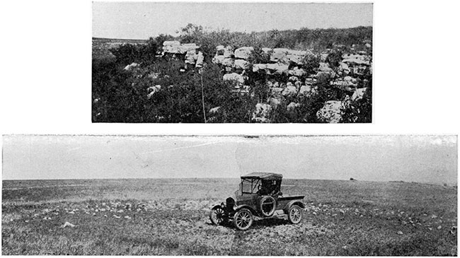
From the base upward the formation comprises a bed of blue-gray limestone 2 1/2 to 4 feet thick, the Americus (?) limestone member; 10 to 13 feet of shale, forming a covered slope in most localities; 2 feet of ocherous weathered limestone, not everywhere exposed; 11 feet of thick-bedded light-buff limestone (see Pl. III) and light tan and blue chert containing large specimens of Fusulina and forming a rock ledge capping the steep slope of the Admire shale, the limestone weathering white and the chert light tan; a covered gently graded slope composed of softer thin-bedded limestone forming a strip from 20 to 50 feet wide extending back of the rock ledge; great slabs about a foot thick of white, weathered limestone like that below; and thin-bedded limestone crowded with large Fusulina, in most localities forming a covered slope. Because of the position of the resistant Foraker limestone above the thick unit of soft shale of the Admire formation erosion has produced long, prong-like ridges capped by the Foraker beds. The steep slopes of the ridges rise 200 to 300 feet above the surrounding surface and project eastward from the Flint Hills rim, forming some of the most rugged topography in Kansas. Thus nearly everywhere along the outcrop of the Foraker formation in southern Kansas the topographic position and prominence of its outcrop are sufficient to identify the formation.
The following section of the Foraker limestone was measured in sec. 34, T. 30 S., R. 8 E.:
| Feet | Inches | ||
|---|---|---|---|
| Elmdale shale | |||
| Foraker limestone: | |||
| Thin-bedded cream-colored limestone, in part crowded with large Fusulina. Forms covered slope | 10 | 6 | |
| Massive light-cream sugary-textured limestone that weathers white and forms a ledge of enormous slabs. The uppermost real prominent bed in the formation contains Fusulina of large size | 1 | ||
| Thin-bedded limestone, with Fusulina, relatively soft and weathers into rocky slope receding from bluff below | 10 | ||
| Thick-bedded light-buff sugary-textured limestone and interbedded tan and blue chert. Large Fusulina occur in the chert and limestone. Forms a bluff | 11 | ||
| Soft limestone; weathers in ocherous-brown thin slabs exposed in places at the foot of the bluff of light-gray limestone. Locally concealed. Fusulina present | 2 | ||
| Gray shale, in part limy | 2 | 6 | |
| Hard, dense blue to blue-gray limestone (Americus [?] limestone member), Contains kidney-shaped nodules of chert 3 to 5 inches in diameter irregularly but not abundantly scattered through the bed. The lowermost few inches of the bed is abundantly fossiliferous. Large specimens of Fusulina occur in the limstone and a few in the chert | 2 | 6 | |
| Total Foraker limestone | 47 | ||
| Admire shale. | |||
A section measured a short distance south of the state line on the Cedarvale-Foraker road, in about sec. 16, T. 35 S., R. 8 E., is as follows:
| Feet | Inches | |||
|---|---|---|---|---|
| Elmdale shale | ||||
| Shale, drab; weathers light tan | 8 | |||
| Shaly limestone, weathering porous, and shale | 5 | 6 | ||
| Tan shale | 2 | |||
| Foraker limestone | ||||
| Limestone, relatively soft, thin bedded; forms covered slope in most localities | 14 | |||
| Light-buff, fairly coarse-grained massive limestone; weathers in large slabs with total thickness of bed, and crops out in slope about 50 feet back of the bluff formed by the lower part of the formation | 1 | |||
| Slope of weathered, relatively thin-bedded limestone | 8 | |||
| Thick-bedded light-buff, weathered gray, fairly coarse-grained limestone, and some interbedded chert. Large Fusulina in limestone and chert. Forms bluff. | 13 | |||
| Shale, in part limy, and covered | 11 | |||
| Americus (?) limestone member | ||||
| Blue-gray dense limestone; abundant Fusulina. | 1 | 2 | ||
| Blue limy shale; weathers tan | 2 | |||
| Blue-gray dense limestone; Fusulina and other fossils, most abundant 8 inches below top | 2 | 7 | ||
| Total thickness of Foraker limestone | 50 | 11 | ||
| Admire shale | ||||
| Dark-gray shale | 8 | |||
| Shaly limestone, blue-gray; weathers tan | 4 | |||
| Gray shale | 1 | 6 | ||
| Shaly tan limestone | 9 | |||
The large Fusulinas so characteristic of the Foraker appear to be present throughout the formation, although they are not everywhere conspicuous on weathered surfaces. The chert occurs mostly interbedded with the thick-bedded ledge. It is not as abundant as in the younger Wreford limestone and Florence flint, but is sufficiently abundant and widespread in occurrence to be conspicuous everywhere in this region, either in place or weathered upon the surface, thus marking the position of the Foraker. For the most part the chert occurs in thin nodular bands or lenses interstratified with limestone beds that are 6 to 18 inches thick. The chert layers commonly follow the bedding planes; some are nodular and some lenticular. Some lenses are 2 to 3 feet long and 4 to 6 inches thick. The chert is blue-gray on freshly broken surfaces but weathers to a light tan color. It can readily be distinguished from chert of other formations of the region by the presence of the well-preserved Fusulinas.
The lower boundary of the Foraker formation is sharply defined by the base of the Americus (?) limestone member, which is more resistant to weathering than the shale beds above and below it, and is in consequence widely exposed. The upper boundary of the Foraker is rarely exposed, as the uppermost limestone beds, which are soft and somewhat shaly, grade into the overlying shale beds and with them form a soil-covered slope. The massive limestone bed that forms large slabs about a foot thick occurs approximately 15 feet beneath the top of the formation, however, and is rather widely exposed, and by measurement from this bed the approximate position of the top of the formation can be located in the covered slopes.
The Foraker limestone can be recognized in most drill records in this general region as the thick limestone above a thick interval of limy shale (Admire) and a short distance below a series of red shale and limestone beds. In cores from core-drill holes it is readily distinguished by the abundance of large Fusulinas, parts of the formation being largely composed of the spindle-shaped tests about one-eighth of an inch in diameter and three-eighths of an inch long. The formation is prominently exposed near the eastern edge of the county in Tps. 32 to 35 S., R. 8 E.
The Foraker limestone was named by Heald, from exposures near Foraker, Osage County, Oklahoma, about 10 miles south of Cowley County (Heald, 1917, pp. 21, 25). In previous Kansas reports the strata of this formation except the lowermost 6 feet have been included in the Elmdale shale. The differentiation of the Foraker limestone in Kansas therefore necessitates a redefinition of the Elmdale shale. The Foraker has not been traced northward beyond the boundary of Cowley County, but it is exposed in central Chase County near the bridge spanning Cottonwood river east of Elmdale, and so it is assumed to be continuous between this locality and Cowley County. At the exposure seen near Elmdale the general features characteristic of the formation in Cowley County are present. It crops out as a thick-bedded limestone massed with large Fusulinas. No chert was seen at this locality, however, and the limestone beds are much softer here than in Cowley County. They are, therefore, readily decomposed, and as a result are covered by a mantle of soil in most localities in this region.
[Note: The section east of Elmdale exhibits clearly all of the subdivisions of the Elmdale shale differentiated and named by Condra in Nebraska (1927, p. 84), with the Americus limestone at the base and Neva limestone at the top. The Foraker probably includes equivalents of the Americus limestone, Stine shale, Houchen Creek limestone, Hughes creek shale and Long creek limestone. In view of the known remarkable lateral persistence of minor stratigraphic units from Nebraska to central Kansas, it is likely that detailed stratigraphic work will afford basis for definite determination of the relations of the type Foraker to Americus and Elmdale.--R. C. Moore.]
The following stratigraphic section was measured a few hundred feet south of the bridge in the SW, sec. 26, T. 19 S., R. 7 E., near Elmdale, Chase County:
| Feet | Inches | |||
|---|---|---|---|---|
| Elmdale shale: | ||||
| Green-gray clay shale | 6 | |||
| Limy shale | 11 | |||
| Foraker limestone: | ||||
| Thick-bedded light-buff soft limestone containing abundant tests of large Fusulinas and some other fossils | 20 | |||
| Covered; some limestone exposed | 8 | |||
| Limy shale | 3 | |||
| Light-buff thick-bedded limestone, containing abundant large Fusulinas and other fossils | 2 | 6 | ||
| Greenish clay shale | 5 | 6 | ||
| Very limy shale | 2 | |||
| Blocky gray dense limestone. Contains abundant large Fusulinas in upper part of bed. Peculiar markings on upper surface. Lowermost 4 inches is massed with an assemblage of fossil shells (Americus [?] limestone member) | 1 | 6 | ||
| Total thickness of Foraker | 42 | 6 | ||
| Admire shale: | ||||
| Tan and gray clay shale | 1 | |||
The blocky bed at the bottom of the Foraker is apparently the lower bed of the Americus limestone as originally described and exposed near Americus, about 25 miles northeast of this locality, and is believed to be continuous with the Americus (?) member of Cowley County (Kirk, 1896, pp. 80, 81).
Americus (?) limestone member. At the type locality of the Americus limestone, a short distance southwest of Americus, Lyon County, Kansas, the following section was measured:
| Feet | Inches | |
|---|---|---|
| Blue-gray fossiliferous limestone, in part crystalline (flagstone bed) | 6 | |
| Abundantly fossiliferous, weathered gray limy shale | 6 | 6 |
| Massive light-buff limestone. Lowermost 5 inches is crowded with fossils and fossil fragments. Uppermost few inches contains large Fusulinas abundantly. Quarried extensively in the years past | 1 | 8 |
The light-buff limestone bed of this section is believed to be continuous with the lowermost limestone unit (about 4 feet thick) in the Foraker limestone in Cowley County. Although the member was not traced across the area intervening between the Americus type locality and Cowley County, exposures of it were seen at a few widely separated localities, and its identity is fairly well established. The upper limestone bed of the section measured near Americus appears not to be widespread. Aside from the fossils mentioned, the general appearance at the outcrop and the stratigraphic relation with beds above and below it, the Americus (?) limestone member has in many localities peculiar markings on its upper surface that resemble hoof imprints made by deer in soft mud and are believed to be significant. They were seen in abundance on the upper surface of the bed near the Cottonwood river bridge 1 1/4 miles east of Elmdale, Chase County; on the upper surface of what is believed to be the same bed in the railroad cut northeast of Grand Summit, Cowley County; and on Rock creek in the extreme southeastern part of Cowley County. As here used the Americus (?) limestone member is the lowermost limestone unit in the Foraker limestone. In Cowley County it ranges between 2 1/2 and 4 feet in thickness, crops out extensively, and nearly everywhere along its outcrop breaks into rectangular blocks that conspicuously mark its position in the slope a few feet beneath the rock ledge formed by the beds in the middle division of the Foraker. Characteristic exposures of this sort were seen also at several localities outside of the county--in northern Oklahoma a few miles south of the southeast corner or Cowley County; in Greenwood County, Kansas, particularly a few miles west of Madison; and in west-central Lyon County southwest of Americus, at the type locality of the member. The Americus (?) limestone is hard and dense, is blue-gray when fresh, and weathers light buff to gray. It commonly contains kidney-shaped nodules of chert sparingly scattered irregularly through the member. In many localities the lowermost few inches of the member is crowded with fossils, and large Fusulinas are scattered throughout the limestone and chert, being particularly abundant near the top of the member.
A section of the Americus (?) limestone member and beds a few feet above and below it, well exposed in a recent road cut in the big hill in the NW, sec. 7, T. 34 S., R. 8 E., on the Winfield-Cedarvale road about 2 1/2 miles southeast of Hooser, is described below:
| Feet | Inches | ||
|---|---|---|---|
| Foraker limestone: | |||
| Thick-bedded light-buff, weathered gray limestone in upper part and weathered ocherous-brown limestone in two beds in lower part. The lowermost foot is almost entirely made up of tests of large Fusulinas | 2 | ||
| Tan-weathered shale. The uppermost few inches is a mass of Fusulinas. At 2 1/2 feet beneath the top is a limestone bed 2 inches thick that is massed with fossils, and 6 inches beneath is another similar bed | 12 | 6 | |
| Americus (?) limestone member: | |||
| Blue-gray, dense, hard, in part crystalline limestone; parts of bed contain abundant large Fusulinas | 4 | 3 | |
| Admire shale: | |||
| Dark-gray, finely laminated shale | 1 | 10 | |
| Tan limestone | 6 | ||
| Gray limy shale | 1 | 5 | |
| Tan fossiliferous shaly limestone | 3 | 8 | |
The Americus (?) limestone member constitutes an excellent key bed for structural geologic mapping in the area of its outcrop in Cowley County, because it is so extensively exposed, regular in thickness, and constant in appearance, and because the ledge forming part of the member varies only a few inches in its stratigraphic position.
Elmdale Shale
As defined by Prosser (1902, p. 708) and subsequently used in Kansas, the Elmdale shale included a series of beds of shale and limestone above the Americus limestone and below the Neva limestone, with a total thickness of 130 feet. The strata between the same limiting beds are but little less than 130 feet thick in Cowley County, but the lower third of this total thickness combined with the Americus (?) limestone is herein called the Foraker limestone, thus restricting the name Elmdale shale to the strata between the Foraker and Neva limestones, having a total thickness of about 80 feet. The lowermost third of the Elmdale formation as thus defined is mostly shale and is succeeded by 20 feet of thin-bedded gray limestone, of which the uppermost 2 to 3 feet is deep buff and soft, the whole 20 feet constituting the Red Eagle limestone member, which forms one of the most prominent ledges in the eastward-facing slope of the Flint Hills. The uppermost two-fifths of the member is composed of red and gray shale, in party limy, containing a few beds of limestone.
The Elmdale shale is exposed in the railroad cut 1 1/2 miles northeast of Grand Summit, where the following section was measured:
| Feet | Inches | ||
|---|---|---|---|
| Neva limestone. | |||
| Elmdale shale: | |||
| Gray limy shale, fossiliferous | 5 | 6 | |
| Blue-gray, dense, massive limestone. Crops out in sharp-edged ledge. Large blocks broken from ledge are strewn along the outcrop line | 4 | ||
| Covered slope, probably shale | 10 | 6 | |
| Thin-bedded light-gray limestone. Forms a band of thin slabs in the grassed slope | 2 | ||
| Covered slope | 5 | ||
| Red shale | 10 | ||
| Red Eagle limestone member: | |||
| Deep-buff coarse-grained soft, massive limestone. Weathers in large rounded nodules conspicuous in slope immediately above the prominent thin-bedded ledge | 3 | ||
| Thin-bedded gray limestone, practically free from fossils | 16 | 6 | |
| Gray shale, in part limy | 18 | ||
| Very limy gray shale | 5 | ||
| Total thickness of Elmdale shale | 79 | 6 | |
| Foraker limestone. | |||
On the headwaters of Rock creek, in the extreme southeastern part of the county, in T. 35 S., Rs. 7 and 8 E., the shale beds of the formation are not well exposed, but the limestone beds form prominent outcrops. The thin-bedded gray limestone of the Red Eagle limestone member, 20 feet above the base of the formation, makes the most jagged-appearing rock ledge cropping out in the Rock creek slopes and is marked by a number of shrubs and trees. At its top and lying a few feet back up the slope from the main ledge is the deep-buff bed that forms the uppermost part of the member. This bed is not continuously exposed, but because of its striking buff color is unusually conspicuous. Above the buff bed, 17 1/2 feet of covered slope intervening, is a bed of weathered dark-gray limestone 1 foot or more thick that is dense, in part crystalline, and weathers with a very sharply rough siliceous surface. At 10 feet above it is a thin-bedded thin gray limestone that is not prominently exposed, but forms a narrow band of platelike slabs on the surface. The Neva limestone caps the slopes.
The Elmdale shale not only has a threefold division in its lithologic composition, but has also a three-fold expression in the surface features it forms. On the divides the lower shale division occupies a broad, gently sloping surface; in the gulches it forms a narrow, steep slope between the Foraker limestone ledge below and the thin-bedded limestone of the Red Eagle member above, which in turn forms a prominent rock ledge or terrace. Next above, the upper half of the member forms a relatively broad band of sloping surface terminated above by the rock ledge of the Neva limestone. The Elmdale shale as a whole occupies a comparatively broad band of the surface, capping the lower of the two main benches of the Flint Hills, from the northern part of T. 32 S., R. 8 E., southwestward across Cowley County into Oklahoma. As a rule the formation is not clearly defined in well logs. In most logs the Elmdale formation is recorded as limestone and shale and is indistinguishable from the Foraker limestone below and the Neva limestone above. Some logs record red shale in parts of the unit occupied by this formation.
The following fossils, collected from the very limy shale in the uppermost few inches of the formation, in contact with the overlying Neva limestone, were identified by G. H. Girty, of the United States Geological Survey:
| U.S.G.S. No. 6163, collected in the SE, sec. 11, T. 34 S., R. 7 E.: |
|---|
| Productus cora |
| Pustula nebraskensis |
| Composita subtilita |
Red Eagle limestone member. The thin-bedded limestone 20 feet above the base of the Elmdale shale is one of the most conspicuous outcropping ledges in the Flint Hills slope. It is about 20 feet thick and consists throughout, except the uppermost 2 to 3 feet, of gray thin-bedded limestone. The top 2 to 3 feet is composed of deep-buff, rather coarse-grained massive limestone that weathers away easily and so is not exposed in all localities. Where present, this bed crops out as large rounded nodular masses, and because of its deep-buff color is unusually conspicuous on the slopes. The lowermost 5 to 10 feet of the member crops out typically as a series of gray beds, each 4 to 6 inches thick, forming a jagged rock ledge 5 to 8 feet thick. The upper part of the thin-bedded portion of the member forms a covered rocky slope capped by the deep-buff nodular bed lying in the slope a few rods back of the principal ledge. More shrubs and trees grow on the rock terrace formed by the Red Eagle limestone than on other beds above or below it.
The Red Eagle limestone was, named by Heald from exposures a few miles south of the Kansas-Oklahoma line, near Red Eagle schoolhouse, southwest of Foraker in northern Osage county, Oklahoma (Heald, 1917, p. 24, 25). The member was not traced northward beyond the boundary of Cowley County, but is believed to be continuous into central Kansas, because a limestone unit at the stratigraphic horizon of the Red Eagle member is exposed near the Cottonwood river bridge 1 1/4 miles east of Elmdale, Chase County.
Neva Limestone
One of the most persistent limestone formations present in Kansas is the Neva limestone, the outcrop of which can be traced from north to south across much of the state and on southward for 75 miles into Oklahoma (Miser, 1926). Characteristically it forms a ledge of dark-gray limestone that weathers to a very rough surface. On freshly broken unweathered surfaces it is buff, and in most localities a sufficient amount of the buff material is exposed in the face of the ledge to lend to the entire outcrop a slight buff hue when viewed from a distance and contrasted with other outcropping beds in the slope. It has not so deep a buff color, however, as the uppermost bed of the Red Eagle limestone, which lies about 35 feet below it. In some localities parts of the formation contain a relatively small amount of chert. The outcropping ledge is commonly only 3 to 6 feet thick, but the entire member has a total thickness of 22 feet in the northeastern part of Cowley County and 28 feet in the southeastern part. The measurement of 22 feet was obtained from an exposure in the railroad cut northeast of Grand Summit, in the SE, sec. 4, T. 31 S., R. 8 E., where the Neva limestone is exposed beneath the red shale in the lowermost part of the Eskridge shale. It consists of bedded buff-gray limestone, in part fossiliferous. Immediately below the Neva is 6 feet of limy shale containing a few thin beds of limestone, which is succeeded below by a massive bed of hard blue-gray limestone that forms a prominent ledge of sharp-edged blocks in this locality. The measurement of 28 feet was made in the railroad cut in the SW, sec. 12, T. 34 S., R. 7 E., 3 miles southeast of Hooser, where the Neva limestone is in part thin-bedded and in part thick-bedded dull-gray and buff limestone containing some chert. Some beds are fossiliferous. Beneath it is 5 1/2 feet of very limy fossiliferous shale, succeeded below by a bed of dense blue limestone that may be the correlative of the "blocky" bed that is present at about this horizon near Grand Summit. Chocolate-colored clay shale occurs in the succeeding formation above the Neva in the southern as well as the northern part of the county, but is rarely exposed.
The Neva limestone is recognizable in logs of drilled wells in this part of the state as the limestone unit above the lowest red shale in this part of the section. This lowest red shale is not reported in all logs, however. The red shale above the Neva in the lower part of the Eskridge shale also aids in the identification. The Neva limestone is one of the most readily recognized of the upper Pennsylvanian and Permian strata penetrated by the drill in Cowley County and can be identified in most of the wells. The formation is recorded as sandy lime in some logs, probably owing to the contained chert. Water is found in the Neva in many wells. The expression of the formation at its outcrop is that of a prominent ledge that lies near the foot of the upper slope of the Flint Hills in Cowley County, or it may be thought of as the highest prominent rock terrace of the lower main bench of the Flint Hills, which is formed mainly by the Foraker limestone below. The Red Eagle limestone and the Neva limestone form ledges or rock terraces at almost equal intervals above the Foraker limestone. Above the Red Eagle and Neva ledges another slope rises steeply to the ledge formed by the Wreford limestone, which caps an extensive plateau forming the crest of the Flint Hills.
Aside from the two localities of measured sections cited, the lower part of the Neva limestone is prominently exposed near the roadway just south of the west quarter corner of sec. 12, T. 34 S., R. 7 E.; near the head of Rock creek, in secs. 13 and 14, T. 35 S., R. 7 E.; and just east of the county boundary beside the highway in the W2, sec. 17, T. 31 S., R. 8 E. The outcrop of the formation as shown on Plate I was rather carefully checked and sketched in the southern half of the area that it occupies. Its position as shown in the northern half was generalized, being in part traced from mapping done by the Empire Gas and Fuel Company, and in part interpolated from the sketched outcrop lines of lower beds.
The Neva limestone was named by Prosser from its exposures northeast of Neva station, on the north side of Cottonwood river at the mouth of Diamond Creek, Chase County, Kansas (Prosser, 1902, p. 709; Prosser and Beede, 1904). The general characteristics of the formation exhibited at its type locality persist southward through Cowley County and into Oklahoma. At its type locality the Neva limestone, 11 feet thick, forms a prominent ledge. It is light gray with a light-buff hue, changes from a massive bed to bedded layers within a few rods along the outcrop, weathers to a pitted, sharply rough surface, and contains fossils in abundance grouped in masses irregularly distributed through the bed.
Eskridge Shale
Red to chocolate-colored, green and gray shale, in part limy, and a few thin beds of limestone, the whole about 35 to 40 feet thick, constitute the Eskridge shale of the Wabaunsee group, named from exposures in the vicinity of Eskridge, Wabaunsee county, Kansas (Prosser, 1902, p. 109). It is the uppermost formation of the Pennsylvanian system in Kansas, and lies above the prominently exposed Neva limestone and beneath the Cottonwood limestone. Inasmuch as the Eskridge shale is a body of relatively soft rocks between two beds of hard limestone, it forms a soil-covered slope terminated below by the Neva limestone bench and above by the Cottonwood ledge, and is rarely exposed. Much of its lower half is reddish to chocolate-colored clay shale, and the upper half is greenish-gray and gray calcareous fossiliferous shale, increasing upward in lime content and abundance of fossils. Its uppermost few feet is crowded with fossils and contains many irregularly shaped tubelike limy concretions constituting its most prominent characteristic. These concretions serve as one of the chief means of identifying the Cottonwood limestone, which overlies the Eskridge shale. Much of the total thickness of the formation is exposed in the railroad cut about 1 1/2 miles northeast of Grand Summit, where the following section was measured:
| Feet | Inches | ||
|---|---|---|---|
| Cottonwood limestone. | |||
| Eskridge shale: | |||
| Covered. (In other exposures in this region this part is yellow-gray to tan calcareous shale crowded with fossils, increasingly abundant upward, Contains many irregularly formed tubelike masses 1 to 1 1/2 inches thick and 2 to 12 inches long) | 13 | ||
| Greenish-gray shale, in part calcareous | 8 | ||
| Reddish to chocolate-colored clay shale | 5 | ||
| Bluish-gray thin-bedded limestone | 1 | ||
| Reddish to chocolate-colored clay shale | 8 | ||
| Covered | 1 | ||
| Total thickness of Eskridge shale | 36 | ||
| Neva limestone. | |||
Southeast of Grand Summit, at the county line on state highway No. 12, the total thickness of the formation is 37 feet, and the uppermost 20 feet is well exposed. Parts of the formation are exposed about 3 miles south of Hooser, in the SE, sec. 11, T. 34 S., R. 7 E., and the uppermost few feet of the formation crops out in the SE, sec. 8, T. 35 S., R. 7 E. The uppermost beds are exposed in a number of localities, but except in a few places the remainder of the formation is concealed. The most extensive outcrop of the Eskridge shale in Cowley County occupies a relatively narrow band extending a little west of south across the county in its extreme eastern part and lying in the eastward-facing slope of the Flint Hills.
The following fossils collected from the uppermost few feet of the Eskridge shale were identified by G. H. Girty:
| U.S.G.S. No. 6162. Collected near the center of sec. 11, T. 34 S., R. 7 E. | |
|---|---|
| Fenestella tenax | Composita subtilita |
| Pinnatapora sp. | Deltopecten occidentalis |
| Septopora biserialis | Deltopecten mccoyi |
| Meekopora prosseri | Pinna peracute |
| Derbya multistriata? | Pseudomonotis equistriata |
| Meekella striaticostata | Pseudomonotis kansasensis |
| Chonetes meekanus | Griffithides sp. |
| Pustula nebraskensis | Ostracoda indet |
| U.S.G.S. No. 6164. Collected in the SE, sec. 8, T. 35 S., R. 7 E. | |
|---|---|
| Fusulina sp. | Pustula nebraskensis |
| Fusulinella sp. | Ambocoelia planiconvexa? |
| Rhombopora lepidodendroides | Deltopecten occidentalis |
| Derbya multistriata | Deltopecten mccoyi |
| Derbya sp. | Euchondria neolecta? |
| Meekella striaticostata | Myalina kansasensis |
| Chonetes granulitfer? | Schizostoma catilloides |
| Productus semireticulatus | |
Prev Page--Stratigraphy, Buried Rocks || Next Page--Stratigraphy, Permian
Kansas Geological Survey, Geology
Placed on web Jan. 5, 2016; originally published May 15, 1929.
Comments to webadmin@kgs.ku.edu
The URL for this page is http://www.kgs.ku.edu/Publications/Bulletins/12/04_strat2.html