Kansas Geological Survey, Bulletin 119, Part 2, originally published in 1956
Originally published in 1956 as Kansas Geological Survey Bulletin 119, Part 2. This is, in general, the original text as published. The information has not been updated.
Six sinkholes involving rocks of Simpson age (Ordovician) were found from examination of logs of wells drilled in eastern Kansas. These sinks contain abnormally thick Simpson sediments, chiefly St. Peter sandstone, which is interpreted as having been deposited as fill in sinkholes developed on an eroded surface of dolomite and limestone of the Arbuckle group. Chert conglomerate and green shale are present in the bottom of the sinks. The shale consists mainly of an illitic clay and quartz, which may be residual weathering products formed in place or washed into the sinks. It is believed that these subsurface features are similar to the Otterville structure in Cooper County, Missouri.
In Kansas the presence of sinkholes is well known, and there are numerous descriptions of them and their mode of development (Frye, 1950; Schoewe, 1949). The best known sinks undoubtedly are those that affect the surface, particularly in western Kansas. The "Meade Salt Sink" developed in Meade County in March, 1879, across a cattle trail. Others of note are Big Basin and St. Jacob's well in Clark County. During the last 60 years, some sinks that developed almost overnight have attracted considerable attention because of their spectacular occurrence. One such example, described by Gordon (1938), developed near Potwin, Butler County, on the afternoon of September 22, 1937, and received world-wide publicity. These sinks affecting the surface are formed in beds ranging in age from Mississippian to Recent.
Of a less spectacular nature are sinkholes in the subsurface. On and along the flanks of the Central Kansas uplift, sinkholes that developed on the Arbuckle (Cambro-Ordovician) surface have been described by Walters (1946). Because of the close spacing of wells drilled in the search for oil in this region, there is abundant subsurface information to show the distribution and size of these solution features with a reasonable degree of accuracy. The karst topography in this region was formed as a result of solution of the dolomite of the Arbuckle group.
A similar development of karst topography on the top of Mississippian rocks is recognized in the subsurface in eastern Kansas and western Missouri. These structures are filled with Pennsylvanian sediments, and evidence of many of the sinks is observable on the surface. An example of a subsurface sink developed on the Mississippian surface in the Davis Ranch Pool, Wabaunsee County, has been cited by Smith and Anders (1951). Surface sinkholes in Cherokee and Mississippian rocks in southeastern Kansas were described by Pierce and Courtier (1937, p. 58-60).
Sinkholes in eastern Kansas filled with Simpson (Ordovician) rocks have been mentioned by Lee and others (1946), Lee, Leatherock, and Botinelly (1948), and Lee and Merriam (1954). In west-central Missouri it is possible to observe on the surface a similar sinkhole filled with Simpson (St. Peter) rocks near Otterville, Cooper County (Kansas Geol. Soc., 1941). By using information obtained in the study of this surface exposure, it is possible to understand better the conditions existing in the subsurface, where well samples provide the only readily available information. These subsurface sinks are not observable on the surface; they are indicated only by abnormal thickness of the Simpson rocks in drill holes.
Examination of logs of wells drilled in eastern Kansas revealed six wells that penetrated abnormally thick sections of Simpson. Because of the scarcity of wells that have been drilled as deep as the Arbuckle in this region, this number of sinkholes is somewhat surprising and would seem to indicate the presence of an extensively developed karst topography on top of the Arbuckle rocks in eastern Kansas. As information is decidedly scanty, it is difficult to make exact interpretations, but it is believed that available data warrant a few preliminary conclusions.
The presence of sinkholes developed on top of the Arbuckle limestone and dolomite surface in eastern Kansas seemingly would indicate a period of weathering and erosion before the deposition of Simpson sediments. This condition, of course, is most favorable for the development of porosity to form possible reservoir beds for the accumulation of oil and gas. Thus, there should be good possibilities for the entrapment of petroleum in the Arbuckle in eastern Kansas under favorable stratigraphic and structural conditions.
We are indebted to Garrett A. Muilenburg, Earl McCracken, and Robert D. Knight of the Missouri Geological Survey for stimulating discussions on Missouri sinkholes and for guidance in the field, and to Wallace Lee, consulting geologist, for critical review of the manuscript.
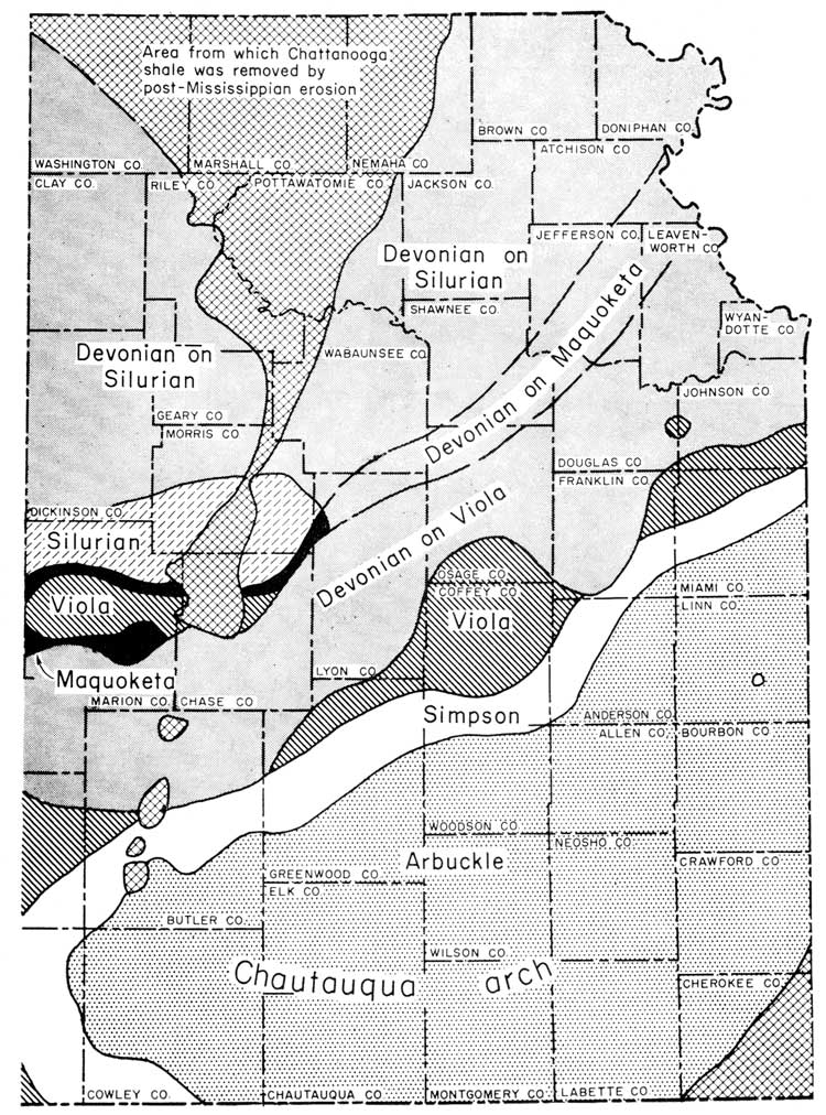
In Kansas the Simpson group is divided into two formations: the St. Peter sandstone (lower) and the Platteville formation (upper). The distribution of this group and other formations beneath the Chattanooga shale in eastern Kansas is shown in Figure 1. A map showing distribution of the group in parts of five states--Nebraska, Kansas, Missouri, Iowa, and Illinois--has been published by Lee and others (1946). A detailed description and correlation of the rocks of Simpson age in Kansas has been given by Leatherock (1945).
Figure 1--Map showing pre-Chattanooga areal geology (from Lee and Merriam, 1954).
According to Leatherock (1945) the St. Peter sandstone consists of three zones: upper and lower zones of sandstone and a middle zone of green clay shale. It is not possible to identify these zones in samples from wells in which the St. Peter fills sinkholes. The St. Peter is composed of white, fine- to medium-grained, well-rounded, frosted, quartz sand. It is loosely cemented with calcareous cement,, but in well samples may occur as loose sand grains. The sand is locally stained reddish by minor amounts of iron oxide in the cement. The normal thickness of the St. Peter in eastern Kansas is 10 to 84 feet (Leatherock, 1945, p. 11). The St. Peter is Chazyan in age, according to Twenhofel and others (1954).
The Platteville formation consists of green shale, limestone, dolomite, and sandstone. A bed in this formation that may be used for correlation is a persistent basal dolomite, which ranges in thickness from 5 to 35 feet (Leatherock, 1945). The formation as a whole is characterized by lateral changes. The maximum thickness of the formation is about 104 feet (Leatherock, 1945, p. 13). Twenhofel and others (1954) assign a Black Riveran age to the Platteville.
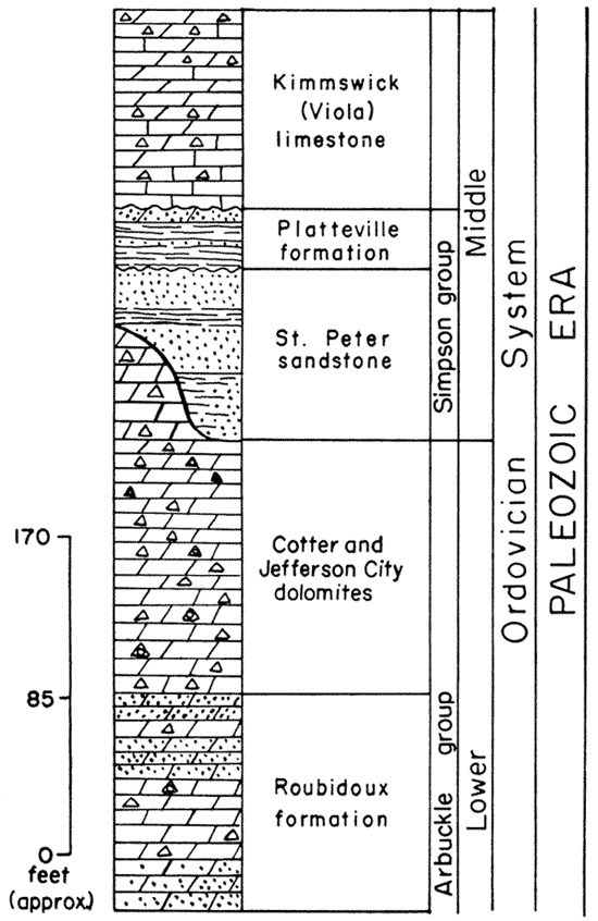
The Simpson group overlies the Arbuckle group unconformably (Fig. 2). In one well cited by Leatherock (1945, pl. 1) the St. Peter lies directly on the Lamotte (Reagan) sandstone; in an area on the Southeast Nebraska arch it overlies Precambrian rocks. Any one of the three zones of the St. Peter may be in contact with the Arbuckle. Thus, the Arbuckle surface presumably was extensively eroded before deposition of the Simpson sediments. The Platteville in turn unconformably overlies the St. Peter sandstone so that it too may be in contact with any one of the three zones. Likewise, the Kimmswick (Viola) limestone unconformably overlies the Platteville formation. These relations are shown on a series of stratigraphic cross sections published by Leatherock (1945, pl. 1).
Figure 2--Generalized stratigraphic section of Ordovician strata (adapted from Moore and others, 1952).
In northeast Kansas and southeast Nebraska, the dominant structural feature in the early Paleozoic was the Southeast Nebraska arch. Some movement occurred on the arch in pre-Roubidoux time, but the major movement occurred prior to the deposition of the St. Peter sandstone (Lee and others, 1946). The arch was a broad north-south-trending structure, the structural axis being situated in approximately the same geographic position as the axis of the present Nemaha anticline. After its uplift but before deposition of the St. Peter, sediments were stripped from the crest of the arch, exposing rocks as old as Precambrian. The thickness of the rocks increases away from the crest of the arch in all directions. A major basin was situated in central Missouri; in it more than 2,000 feet of sediments accumulated and were preserved between the Precambrian and Simpson rocks.
After uplift of the Southeast Nebraska arch and before deposition of Simpson sediments, the Arbuckle was exposed to weathering and erosion on the flanks of this structure. That this surface was extensively beveled is indicated by the occurrence of younger strata in succession away from the crest of the arch.
Beginning with the deposition of the St. Peter, the area of the Southeast Nebraska arch in northeastern Kansas and southeastern Nebraska became a sedimentary basin or negative element termed the ancestral North Kansas basin (Lee and others, 1946). This basin was the dominant structural feature in northeastern Kansas, southeastern Nebraska, and northwestern Missouri until the end of the Mississippian Period when the rise of the Nemaha anticline divided it into the Forest City basin on the east and the Salina basin on the west.
There are numerous outliers of St. Peter sandstone filling sinks or channel-like depressions on the surface and in the subsurface in west-central Missouri. The St. Peter that occurs as outliers is believed to have been preserved because of its stratigraphic position within the sinks or channel depressions. These structures remained intact because they were deeper than the lowest level to which the subsequent erosion progressed. Probably many similar outliers were completely eroded away where the depth of the sink fill did not extend below the level of subsequent erosion. Many isolated bodies of St. Peter, however, are judged to be remnants of a continuous bed of sand that was eroded back to its present truncated position.
On the other hand it is possible that the fill in these sink structures and channel-like depressions is not St. Peter in age but reworked St. Peter sand (Garrett A. Muilenburg, oral communication; Buehler, 1939). If this is the case, then these sinkholes are not necessarily pre-St. Peter or St. Peter in age. The difficulty in determining the age of the sinks results from the lack of beds overlying the fill, making it almost impossible to tell whether the fill is St. Peter or reworked material from that formation.
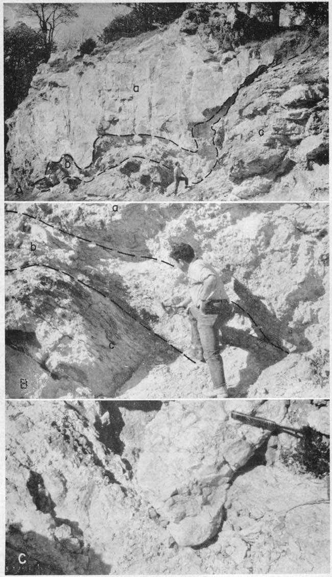
One such outlier that is exposed on the surface, and which has been called a filled sink, is situated near Otterville, Missouri (sec. 35, T. 46 N., R. 19 W.), and is described in the guidebook of the Kansas Geological Society 15th annual field conference (1941, p. 19) and by Bretz (1950, p. 798-800). At the Otterville structure the St. Peter unconformably overlies the Lower Ordovician (Canadian) Cotter dolomite (Pl. 1). The base of the St. Peter consists of a conglomerate in association with green shale, which has been interpreted as residual clay formed by the weathering of the underlying dolomite (Kansas Geol. Soc., 1941). Three samples of green shale were collected; two from the bottom of the sinkhole and one from a shale bed in the Cotter dolomite. X-rays analyses by Jane L. Dalton of the Kansas Geological Survey showed that the shale consists of hydrous-mica clay (including illite and a mixed-layer mineral) and quartz. One of the samples from the bottom of the sink contained a small amount of kaolinite, the other had no quartz; otherwise all three of the samples were almost identical in composition. Ada Swineford (oral communication) suggested that the shale in the sinkhole could be either residual from the weathering of the limestone and dolomite or washed into the structure. Of these two possibilities the latter is more probable. Above the conglomerate is sandstone typical of the St. Peter. According to one explanation the local structure in the Cotter dolomite gives evidence that the rocks had collapsed into a cavern, and later, after a period of weathering, the sink was filled with sandstone of the St. Peter. Interpretation of this sink is that the sandstone at this locality may have been confined to the sink structure and covered by the Cooper (Devonian) limestone, which was subsequently removed by erosion (Kansas Geol. Soc., 1941, p. 19). There is a possibility of some adjustment by slumping of the sand after deposition in the sink. Another interpretation (Bretz, 1950) is that the St. Peter was let down into the sink by slow collapsing of the roof of a cavity. Regardless of the origin, however, it is believed that this structure most closely resembles the sinkholes encountered in the subsurface in eastern Kansas.
Plate 1--A, View of Otterville struction in Cooper County, Missouri; (a) St. Peter sandstone, (b) conglomerate and green shale at bottom of sinkhole, (c) Ordovician Cotter dolomite. B, Closeup of contacts between conglomerate (a), green shale (b), and Cotter dolomite (c). C, Gouge in bottom of sinkhole along east side.
Other similar relations of St. Peter and underlying older rocks are also described in the Kansas Geological Society guidebook (1941). In the NE SE sec. 33, T. 46 N., R. 10 W., a remnant of channel fill of St. Peter occurs in the Jefferson City dolomite (Ordovician, Beekmantown) overlain by the Callaway limestone (Devonian) (Kansas Geol. Soc., 1941, p. 36.). Numerous other outliers of the St. Peter are shown on a cross section from Sedalia to Minneola, Missouri (Kansas Geol. Soc., 1941, p. 42). All these outliers are situated west of the beveled edge of the St. Peter sandstone.
Unklesbay (1952, p. 27) also mentions that the St. Peter fills channel-like depressions at the top of the Jefferson City formation in Boone County, Missouri. He thinks that the St. Peter was deposited in old shallow valleys and was protected from later erosion by its position. It is also probable that the St. Peter was once more widespread than at present and that it was removed by pre-Middle Devonian erosion.
A subsurface pre-Simpson sinkhole is shown on a cross section by Carmody and others (1941) in Putnam County, Missouri, near Unionville. At this locality one well penetrated nearly 200 feet of St. Peter, whereas the normal thickness of the formation in this area seemingly is about 40 feet as shown by the cross section. The St. Peter occurs in a sinkhole, which extends through the Cotter into the Jefferson City. The Decorah-Plattin formations overlie the St. Peter as a continuous cover.
In eastern Kansas, the Simpson filled sinkholes all occur in the subsurface. The location of these sinks is shown in Figure 3. Six wells revealed abnormal thickness of Simpson deposits. Inasmuch as each sink was penetrated by only one well, it is not possible to determine the size or shape of the structures.
Figure 3--Map showing location of known Simpson filled sinkholes in eastern Kansas.

The six wells that penetrate an abnormal thickness of Simpson in eastern Kansas are: Kasper No. 1 James in Johnson County (sec. 8, T. 13 S., R. 25 E.); Clark No. 1 Vaughn in Miami County (sec. 28, T. 17 S., R. 22 E.); Cram No. 1 Allen in Coffey County (sec. 13, T. 21 S., R. 15 E.); Herbel and Tyrrell No. 1 Henning in Coffey County (sec. 22, T. 21 S., R. 16 E.); Evan et al No. 1 Cook in Linn County (sec. 4, T. 22 S., R. 24 E.); and Sinclair-Prairie No. 9 McClaskey in Woodson County (sec. 29, T. 23 S., R. 14 E.) Samples were available from only four of them. A sample log, which had been studied by Hundhausen and Grohskopf, was available for the Clark No. 1 Vaughn well. In the absence of samples or a sample log for the Herbel and Tyrrell No. 1 Henning well, information had to be obtained from a drillers log.
The term "abnormal thickness" is relative, depending on local conditions. For example, in the Evan et al No. 1 Cook well, 40 feet of Simpson, probably representing an erosional outlier, is regarded as abnormal because no Simpson is present in Linn County in any nearby wells. The thickest known section of Simpson in eastern Kansas is 465 feet in the Kasper No. 1 James well. Normal sections of the Simpson range in thickness from about 35 to 170 feet (Leatherock, 1945).
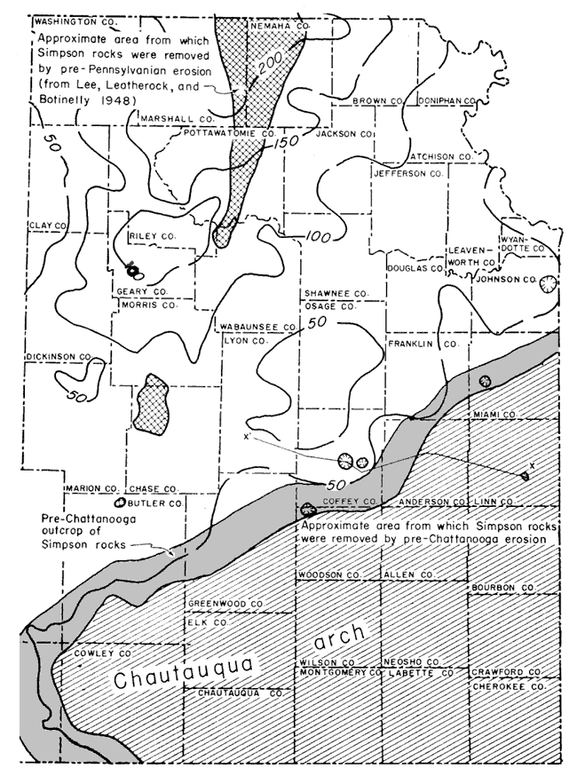
Figure 4 is an isopachous map of the Simpson group in eastern Kansas. The map, contoured on a 50-foot interval, roughly shows the outline of part of the North Kansas basin and Chautauqua arch. The pre-Chattanooga outcrop pattern of the Simpson group outlines the northwestern, western, and part of the southwestern flanks of the Chautauqua arch. The thickness of the Simpson rocks increases to the north into the North Kansas basin. Because both the upper and lower boundaries of the group are erosional, the contours are irregular. With more detailed control, the contours would be even more irregular. The areas from which the Simpson group was removed by post-Mississippian erosion show the crest of the Nemaha anticline.
Figure 4--Isopachous map of Simpson group in eastern Kansas. (Also shows location of cross section, Fig. 6.)
There seems to be a definite relationship of the sinkholes to the pre-Chattanooga outcrop pattern of the Simpson group. The sinks occur close to the outcrop or just down dip. The St. Peter in the sinkhole in Miami County is probably an erosional remnant. One possible explanation for this distribution is that the Arbuckle was more susceptible to solution on the flanks of the rising Chautauqua arch than in the deeper parts of the North Kansas basin. Until more evidence is accumulated, however, this explanation is only tentative.
In Johnson County in the center of the north line of the NE NW sec. 8, T. 13 S., R. 25 E., a dry hole, the Kasper No. 1 James, was drilled in 1937 to a total depth of 2,276 1/2 feet, from a surface elevation of 861 feet. This well penetrated an abnormal thickness of Simpson sediments interpreted as fill in a sink, as has been mentioned previously by Lee and others (1946).
In this well, 465 feet of Simpson is present, of which about 420 feet is St. Peter and the upper 45 feet is Platteville (Fig. 5). The St. Peter unconformably overlies the Arbuckle; the Platteville is overlain by the Kimmswick (Viola) limestone. nere are no other deep wells within a two-mile radius to indicate the normal thickness of the Simpson, but to the west in Douglas County, Leatherock (1945, pl. 1) shows the thickness of the St. Peter in two wells as 55 and 65 feet respectively. The Platteville is missing in these two wells.
Figure 5--Sample log of Simpson group and Kimmswick (Viola) limestone in Kasper No. 1 James well, Johnson County, Kansas. (Samples examined by W.R. Atkinson.) A larger version of this figure is available.
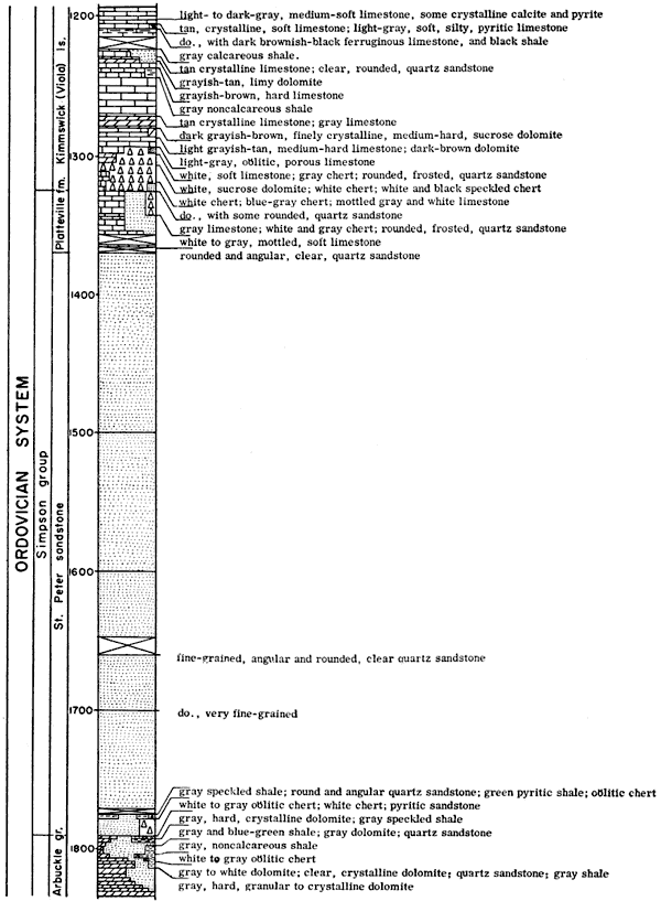
Seemingly the bottom of this sink resembles the bottom of the Otterville structure in Missouri. Green shale and chert occur at the base of the St. Peter in contact with the Arbuckle. From observations of the Otterville structure it may be assumed that the chert is part of a conglomerate in the bottom of the sink, and the green shale is associated with the conglomerate. William Miller, of the Department of Mining and Metallurgical Engineering, prepared an x-ray analysis of the green shale at the bottom of the sink from this well, which revealed a composition similar to that of the green shale in the bottom of the sink at Otterville. The shale is composed mainly of illitic clay and quartz. Above the green shale and chert, the St. Peter is typical fine- to medium-grained, well-rounded, frosted quartz sandstone.
It is possible that there was adjustment of the St. Peter sediments in the sink in post-Simpson time. From examination of well samples, however, it is not possible to tell whether the St. Peter has been disturbed.
Sinkhole B is situated in Miami County in the center of the SE SW sec. 28, T. 17 S., R. 22 E. The Clark No. 1 Vaughn, a dry hole, was drilled into this sink. Total depth of the well is 1,704 feet; the elevation of the well is 990 feet.
This well penetrated 254 feet of St. Peter, but the total thickness of the St. Peter sediments in the sinkhole is not known, because the well did not reach the Arbuckle. The St. Peter is overlain by the Kimmswick (Viola) limestone as the Platteville formation is missing.
The nearest well that penetrated the St. Peter in this vicinity is about 2 miles northeast. There 2 feet of St. Peter is present in the Sloan and Zook No. 1 Fenoughty well. To the northwest, in Douglas County, Leatherock (1945, pl. 1) shows 65 feet of St. Peter overlain by Kimmswick (Viola) limestone.
No samples were available from this well, but a sample log lacking lithologic descriptions had been plotted by Mary Hundhausen and J. G. Grohskopf.
Sinkhole C is situated in Coffey County in the SE NE SE sec. 13, T. 21 S., R. 15 E. The well that penetrated this sinkhole was the Cram No. 1 Allen, a dry hole that was drilled to a total depth of 2,222 feet. The elevation is 1,108 feet. This sink (Fig. 6) was shown on a cross section by Lee and Merriam (1954, pl. 2).
Figure 6--East-west cross section from Linn County to Lyon County, Kansas, showing two Simpson filled sinkholes (adapted from Lee and Merriam, 1954). A larger version of this figure is available.

This well drilled 287 feet of St. Peter sandstone but did not reach the Arbuckle. The St. Peter is overlain by the Kimmswick (Viola). The St. Peter exhibits its characteristic features as a fine- to medium-grained, well-rounded, frosted, quartz sandstone. Some of the sand is iron-stained, giving the sandstone a reddish tint. As the bottom of the sink was not reached, the total depth of the structure is not known.
The well nearest to the well that was drilled into the sink is located about 1 1/2 miles northwest; it penetrated 40 feet of St. Peter but the Arbuckle was not reached in this well either.
The Herbel and Tyrrell No. 1 Henning well penetrated a sink in Coffey County in the NW NW SW sec. 22, T. 21 S., R. 16 E. This well was drilled in 1953 to a total depth of 1,678 feet and penetrated the Arbuckle. It was a dry hole.
No samples were available from the well, and the drillers log includes no detailed lithologic descriptions but does indicate an abnormal thickness of Simpson, which is probably all St. Peter sandstone. About 185 feet of sand was encountered between the Kimmswick (Viola) and the Arbuckle. In a well about 1 mile northwest (Orlanda No. 1 Snider in the NW NW NW sec. 21, T. 21 S., R. 16 E.) only 65 feet of Simpson is present.
From the drillers log it is impossible to tell the condition of the bottom of the sink, as the entire interval, believed to be St. Peter, is logged as sand.
A sinkhole in Linn County in the SE SW SW sec. 4, T. 22 S., R. 24 E., was penetrated by the Evan et al No. 1 Cook dry hole. The elevation is 787 feet; the total depth drilled was 800 feet. This sink (Fig. 6) was also shown on a cross section by Lee and Merriam (1954, pl. 2).
A study of samples from this well revealed that 45 feet of Simpson is present, all of it St. Peter. The St. Peter overlies the Arbuckle, and the Mississippian overlies the St. Peter. The sand is fine- to medium-grained, loose, frosted, well-rounded quartz grains. The Arbuckle is brown dolomite containing transluseent chert. There was no evidence of green shale or conglomerate at the bottom of the sink. The St. Peter in this sink is an outlier on the northwest flank of the Chautauqua arch. No other well in the entire county is known to have encountered St. Peter sand. The outlier is about 25 miles southeast of the truncated edge of the Simpson group (Fig. 1). The most plausible explanation for this outlier is that the St. Peter occupies a sinkhole, and by virtue of its position was preserved until it was permanently covered by Mississippian deposits.
In northwestern Woodson County, the Sinclair-Prairie No. 9 McClaskey well, in the SE SE SW sec. 29, T. 23 S., R. 14 E., penetrated a sinkhole. This well was completed in the Arbuckle in June, 1922, at a total depth of 2,252 feet. It is in the Winterscheid field,, which produces from both the "Bartlesville" and the Mississippian.
This sinkhole is situated just a few miles northwest of the beveled edge of the Simpson group. A study of the samples revealed a thick section of St. Peter sandstone overlain by Chattanooga shale and underlain by Arbuckle dolomite. The sand is about 108 feet thick, in an area where the truncated Simpson should total less than 50 feet. In the lower part of the Chattanooga there is a white sandy limestone, which could be confused with the Kimmswick (Viola) or the "Hunton" (Siluro-Devonian). The uppermost part of the St. Peter is a medium-grained, subrounded, frosted sand of loose quartz grains. Some of the sand is fine-grained and iron-stained. In general the sand seems to be typical St. Peter. At the bottom of the sink is a greenish-gray, waxy, pyritic shale along with white milky and translucent chert. Some of the pyrite has been altered to rust-like porous "blobs", around which the shale is iron-stained. The shale and chert layer is about 6 feet thick. This unit probably corresponds to the conglomeratic zone at the bottom of the sink penetrated by the Kasper No. 1 James well and at the bottom of the Otterville structure in Missouri. The conglomeratic zone overlies the Arbuckle, which is a buff, cherty, crystalline dolomite.
No near-by wells indicate the normal thickness of the Simpson, but from the isopachous map (Fig. 4) it seemingly would be about 20 feet or less.
After the uplift of the Southeast Nebraska arch in southeastern Nebraska and northeastern Kansas, the Arbuckle surface was extensively beveled by weathering, erosion, and solution of the limestone and dolomite of the group. This extensive peneplain-like surface of low topographic relief would be ideal for the development of a karst topography with shallow valleys and channels developed locally. Accompanying the downwarp of the area to form the ancestral North Kansas basin, deposition of sediments of the Simpson group began. The St. Peter, which was deposited on the eroded and uneven surface of the Arbuckle, first filled the previously formed sinkholes and channel-like depressions. Thereafter a general coalescing of the sediments masked the topographic relief of the pre-Simpson surface, forming a continuous deposit. After Simpson deposition, a period of erosion preceded the deposition of the Kimmswick (Viola). Later, after uplift of the Chautauqua arch in southeastern Kansas, the Paleozoic sediments were stripped back from the crest before deposition of the Mississippian strata.
Similar Simpson filled sinks may have been developed on the Arbuckle surface farther west on the Central Kansas uplift, but erosion prior to the deposition of Pennsylvanian beds removed the rocks to a level below the deepest sink. Consequently any evidence of such Simpson filled sinkholes was removed. [Note: After this paper went to press the authors discovered a thesis from the University of Kansas written in 1947 by Kenneth G. Redman on The Ryan Oil and Gas Pool of Rush and Pawnee Counties, West-Central Kansas, which describes Simpson shale associated with angular chert fragments in sinkholes along the Southwestern flank of the Central Kansas uplift.] In northeastern Kansas the Arbuckle surface was covered by Simpson and younger deposits in the North Kansas basin to such a depth that it was not affected by erosion in Desmoinesian time (Pennsylvanian), which developed the karst topography on the Central Kansas uplift. After uplift of the Chautauqua arch the Arbuckle in southeastern Kansas was exposed by the stripping away of the Simpson and younger formations before deposition of the Chattanooga shale. This pre-Chattanooga erosion possibly was not as intense as the erosion in early Pennsylvanian time, which dissected the intervening Mississippian rocks, and did not proceed to the degree of destroying all of the Simpson filled sinkholes.
The bodies of abnormally thick Simpson sediments are believed to fill sinks rather than channels or collapsed structures, although evidence is not conclusive. Regardless of whether the sinks were formed and later filled or whether they developed as the St. Peter was being deposited, they exist. At any rate, from rotary well cuttings it would be difficult to recognize evidence for the mode of formation of the sinks. Then, too, lacking closely spaced well control it would be almost impossible to tell whether the abnormally thick sediments fill deep channels or sinkholes.
Considering all possibilities, sinkholes seem the most plausible explanation for these areas of thick St. Peter sediments. No deep channeling (on the order of 400 feet) of the pre-Simpson surface has been recognized either on the surface in Missouri or in the subsurface in Kansas. The low relief of this surface makes it seem a logical place for karst topography to develop, especially considering that it was underlain by soluble rocks. The distribution of the anomalies parallel to the pre-Chattanooga Simpson outcrop also suggests sinks rather than channeling. Channels would tend to develop perpendicular to the outcrop (which roughly parallels the structural axis of the uplift) and to trend away from the crest of the Chautauqua arch. No abnormally thick Simpson was found at any appreciable distance downdip from the outcrop; the present known distribution does not simulate drainage patterns. Last of all, seemingly there is a similarity between the surface Otterville structure in Missouri and the sinkholes in the subsurface of eastern Kansas.
Because the Platteville formation is not involved in the sinkholes, they are at least pre-Platteville in age and probably are pre-St. Peter (or pre-Simpson) in age.
Bretz, J H. (1950) Origin of the filled sink-structures and circle deposits of Missouri: Geol. Soc. America, Bull., v. 61, p. 789-834.
Buehler, H. A. (1939) "Filled sink" or "cave" deposits in the Ozark region: Kansas Geol. Soc., Guidebook, 13th Ann. Field Conf., p. 138-140.
Carmody, R. A., and others (1941) Geologic cross section from the Granite ridge in southern Nebraska to the Salem field in Illinois: Kansas Geol. Soc., Guidebook, 15th Ann. Field Conf.
Frye, J. C. (1950) Origin of Kansas Great Plains depressions: Kansas Geol. Survey Bull., 86, pt. 1, p. 1-20. [Available online]
Gordon, G. H. (1938) A recent sink hole near Potwin, Kans.: Kansas Acad. Sci., Trans., v. 41, p. 207-210.
Kansas Geological Society (1941) Guidebook, 15th Ann. Field Conf.; Central and northeastern Missouri and adjoining area in Illinois: Kansas Geol. Soc., Wichita.
Leatherock, Constance (1945) The correlation of rocks of Simpson age in north-central Kansas with the St. Peter sandstone and associated rocks in northwestern Missouri: Kansas Geol. Surv., Bull. 60, pt. 1, p. 1-16. [available online]
Lee, Wallace, and others (1946) Structural development of the Forest City basin of Missouri, Kansas, Iowa, and Nebraska: U.S. Geol. Survey, Oil and Gas Investi., prelim. map 48.
Lee, Wallace, Leatherock, Constance, and Botinelly, Theodore (1948) The stratigraphy and structural development of the Salina basin of Kansas: Kansas Geol. Survey, Bull. 74, p. 1-155. [available online]
Lee, Wallace, and Merriam, D. F. (1954) Cross sections in eastern Kansas: Kansas Geol. Survey, Oil and Gas Investi. 12, p. 1-8.
Moore, R. C. and others (1952) Graphic column of Kansas rocks: Kansas Geol. Survey.
Pierce, W. G., and Courtier, W. H. (1937) Geology and coal resources of the southeastern Kansas coal field: Kansas Geol. Survey, Bull. 24, p. 1-122.
Schoewe, W. H. (1949) The geography of Kansas, Part 2, physical geography (geology): Kansas Acad. Sci., Trans., v. 52, p. 261-333.
Smith, R. K., and Anders, E. L. Jr., (1951) The geology of the Davis Ranch oil pool, Wabaunsee County, Kansas: Kansas Geol. Survey, Bull. 90, pt. 2, p. 13-52. [available online]
Twenhofel, W. H., and others (1954) Correlation of the Ordovician formations of North America: Geol. Soc. America, Bull., v. 65, p. 247-298.
Unklesbay, A. G. (1952) Geology of Boone County, Missouri: Missouri Geol. Survey, v. 33, 2d ser., p. 1-159.
Walters, R. F. (1946) Buried Pre-Cambrian hills in northeastern Barton County, central Kansas: Am. Assoc. Petroleum Geologists, Bull. 30, p. 660-710.
Kansas Geological Survey, Geology
Placed on web Aug. 9, 2006; originally published in 1956.
Comments to webadmin@kgs.ku.edu
The URL for this page is http://www.kgs.ku.edu/Publications/Bulletins/119_2/index.html