![]()
Prev Page--Introduction || Next Page--Volcanic Ash Falls
Methods of Correlation
The approach to stratigraphic correlation within a complex of fluviatile deposits is of necessity quite different from the approach generally used for marine strata. Within the volume of sediments under consideration here are no continuous limestone beds, enclosed in shales and marked by distinctive faunas that are susceptible to virtually continuous tracing for hundreds of miles, as is true of the upper Paleozoic and Mesozoic rocks of this general region. In fact, within the Ogallala deposits of the central Great Plains there is no lithologic unit (with the exception of the "Algal limestone" at the stratigraphic top of the formation) that can, with certainty, be traced as much as 10 miles. This fact in itself clearly indicates that the members of the Ogallala are not generally mappable units, that they do not possess the distinct physical contrast with adjacent members (Pl. 1), generally regarded as essential for formal rock-stratigraphic units, and that their correlation must be based primarily on evidence of age relationships. Their status as members is justified, however, by the fact that when viewed grossly and regionally, they do possess general lithologic characters that contrast one to another.
In view of these facts, it is clear that many of the common techniques of correlation are unusable within the Ogallala formation and that it has been necessary to develop little-used or new techniques to establish age relationships within this mass of alluvium. Relations at both the top and bottom have been helpful to correlation; the top is locally marked by a distinctive limestone that serves as a reference, and the configuration of the lower surface indicates location of preexisting valleys and the most likely locale of earliest sedimentation. Correlation by petrographic character of lentils of volcanic ash (Fig. 1), a technique not commonly utilized in study of Neogene strata, has served to establish time equivalence from place to place. Paleontology constitutes the most generally usable line of evidence, fossil plant material being of paramount importance (Fig. 1). Each of these methods of correlation will be briefly discussed.
Figure 1--Maps showing locations of measured sections, localities from which plant fossils and fossil mollusks were collected, and Ogallala volcanic ash deposits in northwestern Kansas. A. Location of measured sections. Figures indicate thickness of Ogallala strata measured at each location. B. Localities from which plant fossils and fossil mollusks were collected. Circles indicate mollusk collections; crosses indicate plant collections. C. Ogallala volcanic ash deposits.
The "Algal Limestone"
The bed within the Ogallala formation that is clearly the most controversial and one of the most distinctive was described by Elias in 1931 and in the Kansas literature is generally referred to as the "Algal limestone" (Pl. 2A). In part his description was as follows (Elias, 1931, p. 136):
"On the top of these beds there was observed a peculiar and remarkably persistent hard limestone, which was traced not only over the larger part of Wallace County but also far north, west and* south in the adjacent area. This ledge of limestone is only 2 to 3 1/2 feet thick. It has an irregularly pitted surface and is made of unstratified, hard, compact, usually pinkish limestone and has a peculiar concentrically banded structure, which resembles closely that of the algal reefs and irregular pisolites of the Green River formation . . . . It is quite clear . . . that the bed belongs to the Ogallala and is the capping rock of the section."
He further stated concerning the Chlorellopsis limestone (Elias, 1931, p. 141):
" . . . the impression of the writer is that this rock was deposited on the nearly flat bottom of a very large and very shallow lake at the close of Ogallala time."
Not only has the presumed equivalent of this bed in the southern Great Plains been a subject of contrasting interpretations, but Elias' concept of origin of the bed in western Kansas has brought discussion in the literature. In 1940 Smith critically discussed the origin of the bed, stating (Smith, 1940, p. 90):
"The considerable difficulties attending this hypothesis are mainly those of satisfactorily explaining the origin of such ponding."
He discussed at some length the structural complications and hydrologic problems involved in such an extensive late Pliocene lake.
Frye (1945a) presented an hypothesis of "Algal limestone" formation in lakes that occupied consequent depressions and abandoned channel segments, after deposition had virtually ceased on the piedmont plain of alluviation that marked the top of the Ogallala deposits.
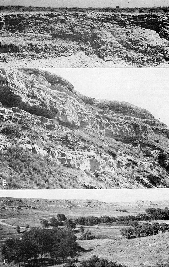
Plate 2--Ogallala formation in west-central Kansas. A. Kimball member with "Algal limestone" bed at top, NW NW sec. 30, T. 18 S., R. 28 W., Lane County (June 1954). B. Middle and Upper Ash Hollow member, Ogallala formation, NW NW sec. 11, T. 16 S., R. 33 W., Scott County (June 1954). See Scott County State Lake section. C. View toward northeast from NW NW sec. 11, T. 16 S., R. 33 W., Scott County, showing exposures of Ash Hollow member, Ogallala formation, along Ladder Creek valley (June 1954).
If this bed was produced in either of these environments--or if we deny evidence of fossil algae and postulate a mode of origin by development of a mature to senile lime-accumulating soil, later modified by solution and redeposition with resultant topographic lowering--the stratigraphic utility of the bed remains equally good. Since Elias first described the bed, there has been no field evidence observed that would deny that it occurs without exception at the stratigraphic top of the Ogallala and is clearly distinguishable from the capping units or calcareous paleosols that mark the termination of deposition of the several Pleistocene cycles of alluviation. In this region it has never been observed conformably overlain in a sequence, of deposits. This is in strong contrast to the western Texas-eastern New Mexico region (Bretz and Horberg, 1949; Price, Elias, and Frye, 1946) where beds of similar appearance are reported to occur both within and as the capping bed of stratigraphic units of several ages, ranging well up into the Pleistocene. Thus, the "Algal limestone" bed can be used in northern Kansas as a datum that marks the top of the formation and the top of the Kimball member. As the Kimball member is relatively thin, and inasmuch as its base is not clearly definable, exploration of its internal stratigraphy has been aided by vertical measurements downward from this bed.
Bedrock Configuration
The base of the Ogallala is useful stratigraphically in a very different way than is the top. Whereas the "Algal limestone" marks a constant stratigraphic position wherever observed, the basal beds at any two localities are unlikely to be at precisely the same stratigraphic position, nor precisely of the same age. All lines of evidence indicate that the Ogallala was deposited by streams flowing in a general easterly direction and that alluviation started in the lowest parts of broad, gently sloping erosional valleys. Therefore, it is expectable that the lowest, hence oldest, members be present in low areas of the bedrock, higher and younger beds transgressively overlapping the gently sloping valley flanks. As this concept has been checked repeatedly by other lines of evidence, it is therefore possible to use it for rough stratigraphic placement of deposits at localities where other evidence is lacking.
The relation of the configuration of the erosional surface at the base of the Ogallala to the stratigraphy of the formation has been fully recognized only recently (Merriam and Frye, 1954). The control exerted on the lower members by the erosional topography of this surface is strikingly illustrated in the generalized cross sections presented in Figure 2, and emphasized by the vertical exaggeration therein. Within the last decade detailed information concerning this surface has become available as a result of test drilling done under the cooperative State and Federal ground-water program. Much of this information recently has been summarized on a map showing areal geology and generalized contours (Merriam and Frye, 1954, pl. 1). Although in southwestern and central Kansas the erosion surface upon which the Ogallala was deposited has been modified significantly by Pleistocene erosion and local faulting, in the northwestern quadrant of the state, which is the area under consideration here, the bedrock surface depicted on the map is essentially the same as it was when Ogallala deposition began.
Figure 2--Diagrammatic cross sections of the Ogallala formation in northwestern Kansas. Based on maps by Merriam and Frye (1954) with schematic conversions of the cross sections to a horizontal plane at the stratigraphic top of the formation.
Volcanic Ash Lentils
The establishment of age equivalence of separated lentils of volcanic ash is judged to be the most precise method of time correlation available to us. The utility of this method for regional correlation of Pleistocene deposits has been demonstrated (Frye, Swineford, and Leonard, 1948), and recently the petrographic characters of the known volcanic ash falls recorded in the Miocene and Pliocene strata of the Great Plains have been described (Swineford, Frye, and Leonard, 1955). The characters of these ash falls will not be redescribed here. It was stated by Swineford, Frye, and Leonard (1955) that the several distinctive falls were differentiated from each other on the basis of differences in index of refraction, shape and thickness of shards, and other factors including chemical composition.
Volcanic ash from as few as two localities but known to be from the same fall may prove of value in stratigraphic correlation. Six ash falls in the Ogallala deposits of Kansas and Nebraska satisfy this minimum requirement, and have been described and named. One of these was studied at eight localities in the two states. Five of these volcanic ash falls are grouped in the middle part of the formation.
Distinctive Rock Types
With the exception of the "Algal limestone" and the volcanic ash lentils, there is a general lack of distinction of lithology among the Ogallala deposits (Pl. 2, 3, 4). There are, however, a few other uncommon rock types that possess, or have been thought to possess, stratigraphic significance. The most distinctive of these are the opal-cemented sandstone and conglomerate; white to gray porcelaneous chert and opal that have replaced calcium carbonate in silty beds; bentonitic clay; and soft limestone or marl, locally containing molds of snail shells.
Plate 3--Ash Hollow member, Ogallala formation, in northern Kansas. A. Middle Ash Hollow member, center W line of the SW sec. 7, T. 8 S., R. 26 W., Sheridan County (June 1954). See measured section for seed lists. B. Lower Ash Hollow member resting on uppermost Valentine member, exposed in south bluff of Sappa Creek valley NW NE sec. 34, T. 1 S., R. 27 W., Decatur County (July 1953). Abundant and diversified fossil seeds listed in measured section. C. Middle Ash Hollow member, SW sec. 30, T. 5 S., R. 22 W., Norton County (June 1954). Fossiliferous Valentine member exposed below Ash Hollow member at this locality. Fossil seeds listed in Edmond measured section.
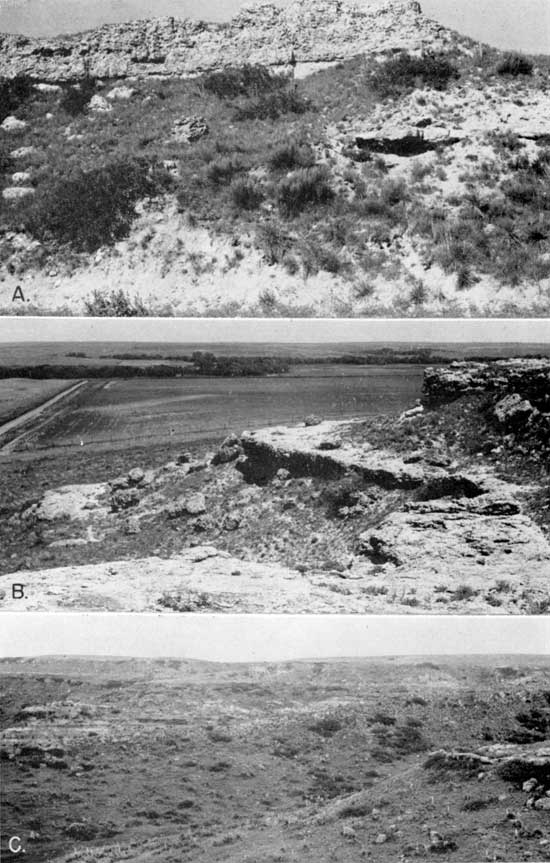
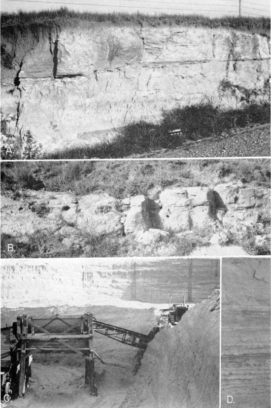
Plate 4--Ogallala volcanic ash. A. Dellvale volcanic ash bed, middle Ash Hollow member, NW NW sec. 2, T. 4 S., R. 24 W., Norton County (June 1954). The pick marks the base of the volcanic ash bed; fossil seeds are listed in measured section. B. Rawlins volcanic ash bed; lower Ash Hollow member, SE SE sec. 8, T. 14 S., R. 38 W., Wallace County (June 1954). See measured section. C. Calvert volcanic ash bed at type locality. Upper Valentine member, at Calvert, Norton County. The pit is operated by Wyandotte Chemical Corporation (1945). Fossil seeds are listed in Figure 3. D, Ripple marks in volcanic ash at Calvert mine.
Opal-cemented rock
The petrography of the opal-cemented rock was described by Frye and Swineford (1946), who believed that rocks of this particular lithology occur only in the lower part of the formation, below the zone within which the volcanic ash lentils are concentrated. They concluded that the source of the silica was the numerous lentils of volcanic ash at and above the stratigraphic position of the opaline sandstone (Frye and Swineford, 1946, p. 57) and thus these distinctive lentils have a general stratigraphic significance. The color of the cement (various tints of green) and its hardness and resistance to erosion make this particular rock type easily recognizable in the field.
Chert
The zones of white to gray chert, opal, and calcium carbonate rocks that generally lack clastic quartz grains coarser than silt or fine sand have a stratigraphic implication, different from that which may be inferred from the occurrence of opal-cemented rocks. Elias (1931, p. 136) described chert and moss agate a few feet below the "Algal limestone" in Wallace County and elsewhere. This rock is petrographically quite different from the green opaline sandstone (Frye and Swineford, 1946) and has been observed at many places in western Kansas in the Kimball member. Where its stratigraphic relation to the "Algal limestone" has been determined it occurs within 10 or 15 feet below that bed. Although the origin of this particular lithology is not clear, the chert seems to be genetically related to the relatively stable surface that developed on the alluvial plain after termination of Ogallala deposition. Although by no means a definitive stratigraphic marker, rock of this unusual lithology has some local utility.
Bentonitic clay
Relatively pure clay beds are not a common type of rock in the Ogallala, but they have been observed at several localities. Elias (1931, p. 153-158) discussed at some length the occurrence of these clays at the base of the Ogallala in Wallace County and elsewhere in northwestern Kansas. He stated (Elias, 1931, p. 153):
"In the basal part of the local exposures of Ogallala, there appear beds of fine plastic greenish and maroon-brown bentonitic clays interbedded with soft, dusty grit and sands."
He applied the name "Woodhouse clays" from a locality one mile east of Woodhouse ranch in Wallace County. The clay beds at all localities described are at or near the base of the Ogallala formation and he concluded that the deposits were for the most part the product of weathering of volcanic ash that had been deposited on the surface of the Cretaceous shale and chalk before the Ogallala was deposited, or very early during the deposition of these beds (Elias, 1931, p. 156-157). Subsurface samples of clay of similar appearance from the base of the formation in Thomas County have been described (Frye, 1945, p. 67) but it was suggested that this clay might be a weathering product of the underlying Cretaceous Pierre shale. Similar clays in Phillips County (Landes and Keroher, 1942) and in Norton County (Frye and Leonard, 1949; Byrne, Beck, and Bearman, 1949) have been described. Although clays of this type are clearly not restricted to one stratigraphic position, they are known principally from the basal part of the formation, but a few thin bentonite lentils are also observed at higher stratigraphic positions within the Ogallala. One such bed, about a foot thick, occurs above the volcanic ash in the Calvert ash mine in Norton County. Thin bentonites also occur interbedded with sand and gravel in an abandoned opaline-sandstone quarry near Woodruff. Bentonites are also reported in the lower part of the Ogallala in test holes in Phillips and Norton Counties (Frye and A. R. Leonard, 1949, p. 114, 117).
Bentonite lentils are seemingly restricted to the Valentine member of the formation; the alteration of the ash to montmorillonite may be related to high ground-water levels that obtained during the deposition of the Valentine and to the availability of magnesium ion from nearby Cretaceous marine shales.
Marl
Soft, silty to sandy diatomaceous limestone or marl is another distinctive rock type within the formation (Frye and Leonard, 1949). Although rocks of this lithology are more common in the lower half than the upper half of the formation, they are present at many stratigraphic positions and therefore have little stratigraphic value. At many places, however, rocks of this type contain molds and casts of fossil snails, which contribute greatly to our knowledge of the molluscan faunas.
Stratigraphic Sequence
One of the oldest techniques of stratigraphical geology is the comparison of sequences of rocks at different localities. The classic procedure of measuring a rock sequence and noting the relative position therein of distinctive fossils or of significant rock types and other data remains a fundamental tool of the stratigrapher, whether he is dealing with thin-bedded marine strata, or, as we are here, with a thick alluvial blanket. It is true that many of the details observed in a sequence of rocks have in themselves small utility in correlation, but they may give meaning to other criteria used. Thus, in the Ogallala formation, few individual beds have stratigraphic significance, but in general the beds fall into an indistinct but observable pattern that changes in character from the bottom to the top of the formation. This changing pattern is discernible in the graphic sections on Plate 1, and in more detail in the descriptive sections at the end of this report.
Fossil Vertebrates, Mollusks, and Plants
Fossil vertebrates have generally proved of greatest value in regional correlation of Cenozoic deposits, but have been utilized also for broad intercontinental correlations on the one hand and purely local correlations on the other. The assignment of Neogene age to the Ogallala deposits in northwestern Kansas, for example, has rested for many years on evidence based on a few collections of fossil vertebrates. For the detailed correlations attempted here, however, the collections available are inadequate because of their erratic vertical and areal distribution. Additional collecting would undoubtedly prove profitable, but inasmuch as such collections, well distributed throughout the stratigraphic section and the area, are not known to us our correlations depend but little on evidence from fossil vertebrates.
Elias, Frye, and others have noted fossil mollusk shells in a few places and molds of mollusk shells in limestone at many localities within the Ogallala but they did not determine the kinds of mollusks in the formation nor their vertical and regional distribution. Our studies have been limited, partly because of the labor involved in casting the molds, to the molluscan faunules at eight stratigraphically significant localities, but molds of mollusks are known to occur at many other localities. The small number and circumscribed distribution of the localities from which fossil mollusks have been obtained has severely restricted the use of these fossils in detailed correlation studies, but suitable collections of fossil mollusks permit correct placement of Ogallala beds in the recognized members.
Fossil plant remains, consisting of the excellently preserved hulls of grass seeds and nutlets or fruits of other plants, are widely distributed in Ogallala sediments in northwestern Kansas; this fact, and the pioneer work of Elias (1942) in establishing the approximate vertical range of the several kinds of plants represented in Neogene sediments in Kansas and Nebraska, give these fossils prime importance in both local and regional correlations in the area covered by Ogallala deposits. Most local assemblages of fossil seeds are sufficiently distinctive to permit recognition of at least the member of the Ogallala formation and, in the Ash Hollow, to permit stratigraphic placement even within the lower, middle, or upper part of the member.
Prev Page--Introduction || Next Page--Volcanic Ash Falls
Kansas Geological Survey, Geology
Placed on web Aug. 4, 2011; originally published March 1956.
Comments to webadmin@kgs.ku.edu
The URL for this page is http://www.kgs.ku.edu/Publications/Bulletins/118/03_corr.html