Kansas Geological Survey, Bulletin 114, part 4, originally published in 1955
Originally published in 1955 as Kansas Geological Survey Bulletin 114, part 4. This is, in general, the original text as published. The information has not been updated.
Structure maps on the Stone Corral formation of Permian age and on the Lansing group of Pennsylvanian age for 10 oil fields in central and western Kansas are compared. All the fields are relatively recent discoveries and are located in different structural provinces. The study shows that the structure on the Stone Corral reflects the Pennsylvanian structure with reasonable accuracy in 9 of the 10 fields. The lack of agreement in the Sunny Slope field may be due to lack of control.
The oil geologist is concerned primarily with finding geological traps of a character likely to provide reservoirs in porous rocks in which petroleum may accumulate. The most common type of trap in western Kansas occurs beneath local anticlines. Exploration can be carried on by surface mapping, subsurface mapping, and geophysics or a combination of these methods depending on the geological conditions. Over much of the area of western Kansas, generally speaking, surface mapping cannot be used reliably for determining structure at depth because the structural pattern of the Tertiary and Cretaceous rocks differs from that of the deeper Permian, Pennsylvanian, and older rocks. Consequently most of the exploration is carried on either by subsurface or geophysical methods in order to determine the structure of the older beds which lie below the surficial mantle of Cretaceous, Tertiary, and Quaternary strata (Merriam and Frye, 1954).
The Stone Corral formation of Permian age is the youngest formation that is both widely distributed and lithologically distinctive. It is, therefore, a good marker and is commonly used in structural work involving the pre-Cretaceous rocks of western Kansas. The Lansing group of Pennsylvanian age, which lies from 1,000 to 2,000 feet below the Stone Corral formation, is an important oil-producing zone. Because the Stone Corral occurs at shallower depths than the Lansing, it can be used as a datum horizon for geophysical, mainly seismograph (Glover, 1953), and core-drill exploration. It is the purpose of this paper to demonstrate that the Stone Corral reflects the structure of the older beds and thus is a good indicator of structure of the Pennsylvanian rocks and especially the Lansing group at depth in western Kansas.
Previous studies--A structural map on the Stone Corral formation for the WaKeeney oil field in Trego County, Kansas, which produces from the Lansing-Kansas City sequence, was published by Landes and Keroher (1939). Lee and Merriam (1954) show the regional structure on the Stone Corral formation for all of western Kansas. Merriam and Goebel (1954) show the structure of the Norton oil field, in Norton County, Kansas, both on the Stone Corral formation and on the Lansing group. Merriam and Atkinson (1955) present structure maps on the Stone Corral and Lansing and an isopach of that interval for the vicinity of the Cambridge arch. A regional isopachous map of the interval between the Lansing and the Stone Corral for western Kansas is shown by Merriam (in press). All this work has shown that there is a marked coincidence of structure on the Stone Corral and Lansing.
Present studies--For this study, maps have been prepared showing the structure on the top of the Stone Corral formation and on the top of the Lansing group in 10 oil fields in central and western Kansas: Adell (Sheridan County), Hayden (Rooks County), Hickman (Stafford County), Jennings (Decatur County), Law (Graham County), Nunn (Finney County), Ruggles (Osborne County), Stuttgart (Phillips County), Sunny Slope (Trego County), and Walz (Trego County). The location of these oil fields and their relation to major structural features of western Kansas are shown in Figure 1. All these fields except the Sunny Slope, which produces from Pennsylvanian Marmaton beds, produce from the Lansing-Kansas City sequence.
Figure 1--Index map showing location of oil fields discussed in this report and their relation to post-Mississippian structural elements of western Kansas.
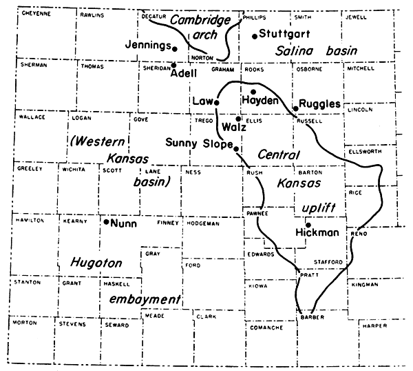
These fields were selected because (1) all produce from Pennsylvanian rocks; (2) they are located in different structural provinces--Hugoton embayment (Western Kansas basin), Central Kansas uplift, Cambridge arch, and Salina basin; (3) all are recent discoveries (Nunn, the oldest, was discovered in 1938) and considerable information, such as electric logs, is available; and (4) they are large enough to show the structure with considerable accuracy.
Information on the two datum planes--the top of the Stone Corral and the top of the Lansing--was obtained from electric logs, drillers logs, and scout tops. Producing wells and dry holes are shown on each map. In each field the structure contours on a 10-foot interval of both datums are superimposed for comparison (Figs. 2-11).
The stratigraphy is treated only briefly here; the reader is referred to Moore and others (1951) for a more comprehensive discussion.
The Stone Corral formation is the uppermost unit of the Sumner group of the Leonardian Series of Permian age. The formation is composed of anhydrite, dolomite, and shale. On the outcrop the anhydrite is leached out leaving only the dolomite. In the subsurface the formation consists largely of white to light-gray crystalline anhydrite which is commonly called the Cimarron anhydrite. The thickness of the formation ranges from 25 to 100 feet. In southwestern Kansas where the formation is the thickest it consists of two anhydrite beds separated by red shale (Lee and Merriam, 1954).
In outcrops the Lansing group (Missourian Series of Pennsylvanian age) is divided into three formations: Stanton limestone, Vilas shale, and Plattsburg limestone. The formations are subdivided into members, but in the subsurface these subdivisions are not easily identified especially in rotary well samples. The limestone is white to bluish gray, fine grained, and is thin bedded on the outcrop. The shale is gray, green, and black, clayey, and locally sandy. The average thickness of the group is about 85 feet on the surface (Moore and others, 1951, p. 78).
The Kansas City group, which underlies the Lansing, has an average thickness of 350 feet on the surface (Moore and others, 1951, p. 81). This group, like the Lansing, consists mainly of limestone, shale, and some sandstone. Oil produced from zones in the Lansing or Kansas City group is usually reported as Lansing-Kansas City production.
The regional structure on top of the Stone Corral formation has a northerly dip of about 5 feet to the mile in western Kansas, except in the area of the Cambridge arch and in parts of Comanche, Barber, and Kingman counties where it dips south. The Cambridge arch and Western Kansas basin are revealed by the configuration of the contours, but the Central Kansas uplift and the Salina basin are not recognized as such. The regional structure on top of the Lansing group has a southerly dip of about 5 feet to the mile into the Hugoton embayment. The Cambridge arch is also distinctly recognizable as well as the Central Kansas uplift and Salina basin to a lesser degree. The north dip on the Stone Corral formation and the south dip on the Lansing group produce a convergence to the north of about 10 feet to the mile. This convergence, although small, is important in considering the relationship of the structure on the Stone Corral formation and the Lansing group. This is especially true since the structural closure in most of the oil fields is small.
An explanation on some points concerning the structural development of western Kansas is probably in order at this place. Whether or not a major or minor structural feature is revealed on a structure map is dependent on the time when that feature was developed. Thus, because the Cambridge arch continued to develop after the Central Kansas uplift became quiescent, it is recognizable on the Stone Corral structure map whereas the Central Kansas uplift is not. This also is the case for the Hugoton embayment which was partially obliterated and modified by the post-Permian northerly tilting which formed the Western Kansas basin. However, this tilting was not steep enough to reverse the southerly dip of the older beds. Thus, the Mesozoic strata dip to the north and the Paleozoic strata dip to the south which explains the convergence of the interval between the Stone Corral formation and the Lansing group.
The following discussion points out relation of the structure on the top of the Stone Corral formation to the structure on the top of the Lansing group in 10 central and western Kansas oil fields.
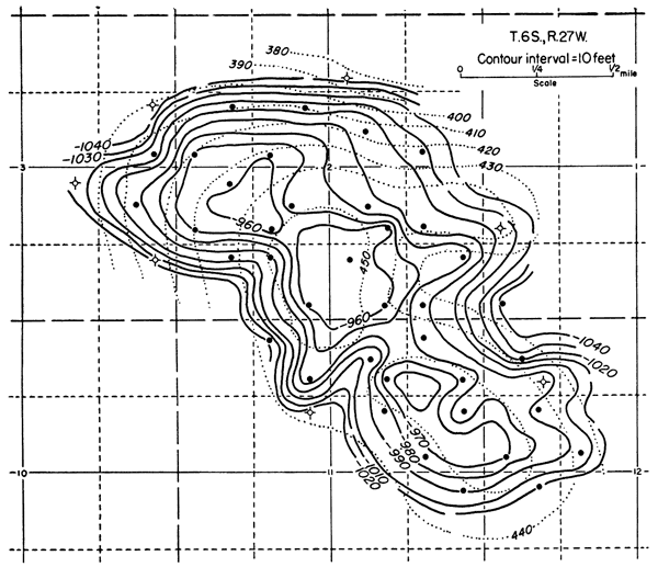
The Adell field, in Sheridan County in secs. 1, 2, 3, 11, and 12, T. 6 S., R. 27 W., was discovered in 1944. Cumulative production at the end of 1953 was 2,974,334 barrels of oil from the Lansing-Kansas City at a depth of 3,755 feet in the discovery well. The field covers an area of 1,200 acres; 1953 production was from 38 wells.
Structurally, the field is situated on the Jennings anticline (Merriam and Atkinson, 1955) on the west flank of the Cambridge arch. Several other oil fields are also located along the crest of this anticline where local areas of closure occur. The dip on the west side of the anticline is steeper than on the east side and the structure plunges to the south and southeast.
The Adell field (Fig. 2) is on a closed anticline which trends northwest-southeast. Three separate areas of closure on the Lansing are revealed. Maximum overall closure is 55 feet and the southeast end of the producing area is not yet defined, so that the total closure of the structure may be considerably more. The Stone Corral structure has a maximum closure of only 16 feet and there are two separate areas of closure. The structure on the Stone Corral and on the Lansing is very similar, especially in areal extent and geographic position. However, the difference in magnitude is striking.
Figure 2--Structure map on top of the Stone Corral (dotted contours) and Lansing (solid contours) of the Adell oil field, Sheridan County, Kansas.
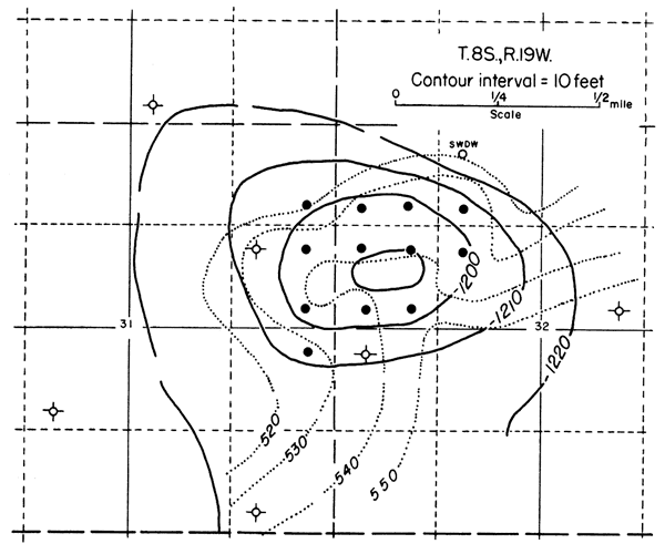
The Hayden field, located in Rooks County in secs. 31 and 32, T. 8 S., R. 19 W., was discovered in 1949. Cumulative production at the end of 1953 was 431,677 barrels of oil from the Lansing-Kansas City and Arbuckle at depths of 3,289 and 3,513 feet, respectively, in the discovery well. The field covers an area of 360 acres; 1953 production was from 13 wells.
Structurally, the field is situated on the northern end of the Central Kansas uplift just south of a large broad synclinal area which separates the Central Kansas uplift from the Cambridge arch (Lee and Merriam, 1954, pl. 1). The regional dip of the Stone Corral is north and the regional dip of the Lansing is slightly south.
Production is from a zone in the Lansing group on a slightly elongated closed anticline. The structure has a northwest-southeast trend and shows a closure of about 20 feet (Fig. 3). The structure on the Stone Corral formation is an elongated northeast-southwest anticline that shows no closure with a 10-foot contour interval and that flares from a northwesterly plunging structural nose. A similar relation was shown by Landes and Keroher (1939, p. 43) in the Wakeeney field where the structure on the Stone Corral has the same pattern.
Figure 3--Structure map on top of the Stone Corral (dotted contours) and Lansing (solid contours) of the Hayden oil field, Rooks County, Kansas.
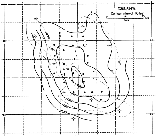
The Hickman field, located in Stafford County in secs. 27 and 34, T. 21 S., R. 14 W., discovered in 1951, had a cumulative production of 519,571 barrels of oil at the end of 1953 from Lansing-Kansas City and Simpson from depths of 3,522 and 3,747 feet, respectively, in the discovery well. The field covers an area of 760 acres; 1953 production was from 19 Lansing-Kansas City and 4 Simpson wells.
Structurally, the field is situated near the western margin of the Central Kansas uplift. The regional dip on the Stone Corral formation is to the north (Lee and Merriam, 1954, pl. 1).
The structure on the Lansing is irregular but shows a slight elongation in a northwest-southeast direction. There is about 20 feet of closure on this datum (Fig. 4). The structure on the Stone Corral is also irregular and shows only about 18 feet of closure. The crest of the anticline is located almost in the same place at both horizons.
Figure 4--Structure map on top of the Stone Corral (dotted contours) and Lansing (solid contours) of the Hickman oil field, Stafford County, Kansas.
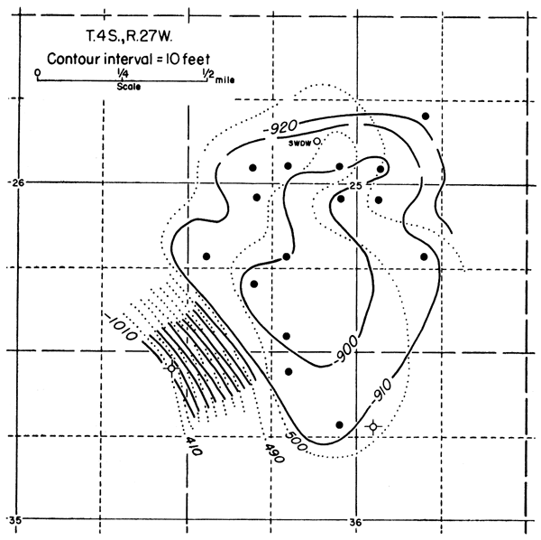
The Jennings field, located in Decatur County in secs. 25 and 36, T. 4 S., R. 27 W., was discovered in 1951. Cumulative production was 91,017 barrels of oil at the end of 1953 from the Wabaunsee group and from the Lansing-Kansas City at depths of 3,156 and 3,478 feet, respectively, in the discovery well. The field covers an area of 720 acres and 1953 production was from 11 wells.
Structurally the field is situated on the Jennings anticline which borders the western side of the Cambridge arch (Merriam and Atkinson, 1955). The Jennings anticline has already been discussed under the Adell field.
The structure map on the Lansing group (Fig. 5) reveals that the production is from a north-south elongated closed anticline. There is about 13 feet of closure on the structure, but inasmuch as the crest of the structure is yet undrilled, greater closure may be revealed later. The west flank of the structure is steep in comparison to the east flank. The closure on the Stone Corral amounts to about 10 feet. The structure on the Stone Corral is closely similar to the structure on the Lansing.
Figure 5--Structure map on top of the Stone Corral (clotted contours) and Lansing (solid contours) of the Jennings oil field, Decatur County, Kansas.
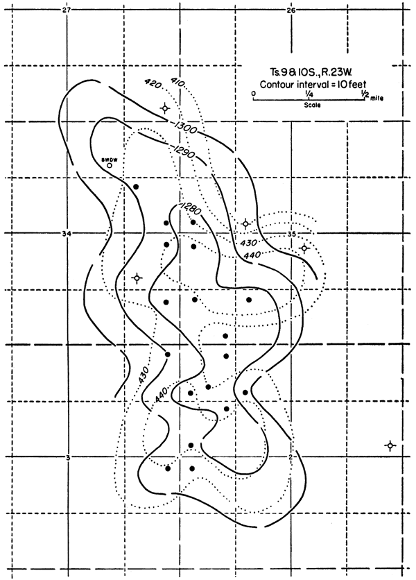
The Law field, located in Graham County in secs. 34 and 35, T. 9 S., R. 23 W. and secs. 2 and 3, T. 10 S., R. 23 W., was discovered in 1951. Cumulative production was 405,099 barrels of oil at the end of 1953 from the Lansing-Kansas City and Pennsylvanian basal conglomerate at depths of 3,922 and 4,126 feet, respectively, in the discovery well. The field covers an area of 860 acres; 1953 production was from 12 Lansing-Kansas City and 2 Pennsylvanian basal conglomerate wells.
Structurally, the field is situated on the northern end of the Central Kansas uplift just south of a large broad synclinal area which separates the Central Kansas uplift from the Cambridge arch. Its regional structural position is similar to that of the Hayden field in Rooks County.
The structure on the Lansing (Fig. 6) reveals an elongate north-south trending symmetrical anticline with a closure of about 16 feet. The structure on the Stone Corral coincides approximately with the structure on the Lansing and also shows about 16 feet of closure. The closure on the Stone Corral occurs, however, in two separate areas whereas there is only one large closure on the Lansing.
Figure 6--Structure map on top of the Stone Corral (dotted contours) and Lansing (solid contours) of the Law oil field, Graham County, Kansas.
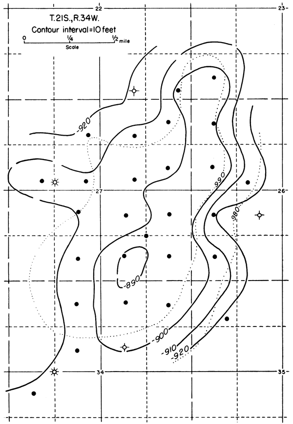
The Nunn field, located in Finney County in secs. 22, 23, 26, 27, 34, and 35, T. 21 S., R. 34 W., was discovered in 1938. Cumulative production was 1,989,381 barrels of oil at the end of 1953 from the Kansas City, Marmaton, "Cherokee," and "Mississippi lime." Production is from the "Cherokee" at 4,550 feet and from the "Mississippi lime" at 4,654 feet in the discovery well. The field covers an area of 1,300 acres; 1953 production was from 28 wells.
Structurally, the Nunn field is situated on a northeast-southwest trending anticline on the west flank of the Western Kansas basin as shown by Lee and Merriam (1954, pl. 1). The regional dip on the Stone Corral formation is northeastward. The Shallow Water and Keystone oil fields are also located on the same structural trend.
The structure on the Lansing (Fig. 7) reveals a northeast-southwest trending closed anticline with about 13 feet of closure. The structure on the Stone Corral has only about 10 feet of closure. The two structure maps coincide closely.
Figure 7--Structure map on top of the Stone Corral (dotted contours) and Lansing (solid contours) of the Nunn oil field, Finney County, Kansas.
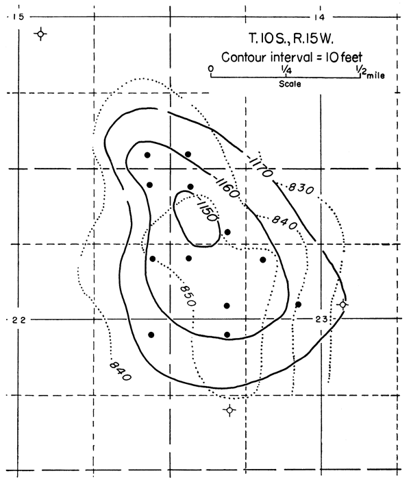
The Ruggles field, located in Osborne County in secs. 14, 15, 22, and 23, T. 10 S., R. 15 W., was discovered in 1952. Cumulative production was 156,015 barrels of oil at the end of 1953 from the Shawnee, Lansing-Kansas City, and Pennsylvanian basal conglomerate at depths of 2,986, 3,024, and 3,394 feet, respectively, in the discovery well. The field covers an area of 640 acres; 1953 production was from 12 wells.
Structurally the field is situated in the Salina basin just east of the east margin of the Central Kansas uplift. It seems to be on the same anticlinal axis as the Fairport anticline (Lee and Merriam, 1954, pl. 1). It is the only producing field in Osborne County.
The structure on the Lansing (Fig. 8) is an ovate north-south trending anticline with closure of about 20 feet. The Stone Corral structure is similar to that of the Lansing but is wider. Closure as shown on the Stone Corral is about 9 feet.
Figure 8--Structure map on top of the Stone Corral (dotted contours) and Lansing (solid contours) of the Ruggles oil field, Osborne County, kansas.
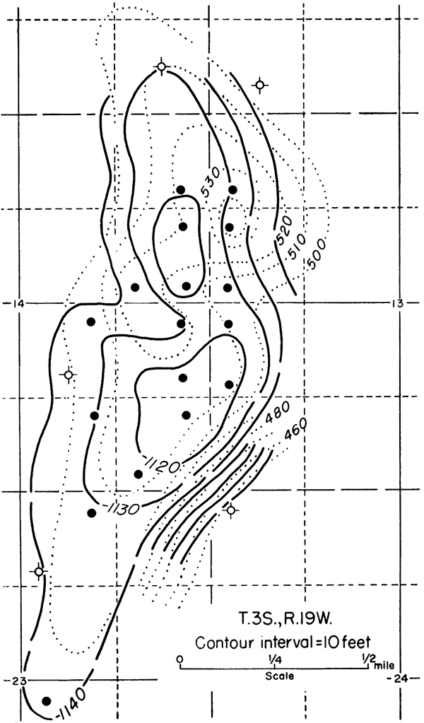
The Stuttgart field, located in Phillips County in secs. 13, 14, and 23, T. 3 S., R. 19 W., was discovered in 1950. Cumulative production was 186,946 barrels of oil at the end of 1953 from the Lansing-Kansas City at a depth of 3,146 feet in the discovery well. The field covers an area of 600 acres; 1953 production was from 12 wells.
Structurally the field is situated on the Stuttgart-Huffstutter anticline which parallels the eastern edge of the Cambridge arch and trends northeast-southwest. It is separated from the Cambridge arch by the northeasterly plunging Long Island syncline (Lee and Merriam, 1954, pl. 1); Merriam and Atkinson, 1955). There are several major oil fields located on this structure including the Huffstutter, Dayton, Stuttgart, Hansen, and Ray fields.
The structure on the Lansing (Fig. 9) reveals a northeast-southwest trending anticline with a closure of about 28 feet. The southeastern flank of the anticline is steep compared with the northwestern flank. Two separate areas of closure occur in the field. The Stone Corral structure also shows a northeast-southwest trending anticline with about 47 feet of closure. The southeastern flank is steeper than the northwestern flank. The structure on the two horizons is remarkably similar, except for the displacement of the crest on the Stone Corral east of the closure on the Lansing.
Figure 9--Structure map on top of the Stone Corral (dotted contours) and Lansing (solid contours) of the Stuttgart oil field, Phillips County, Kansas.
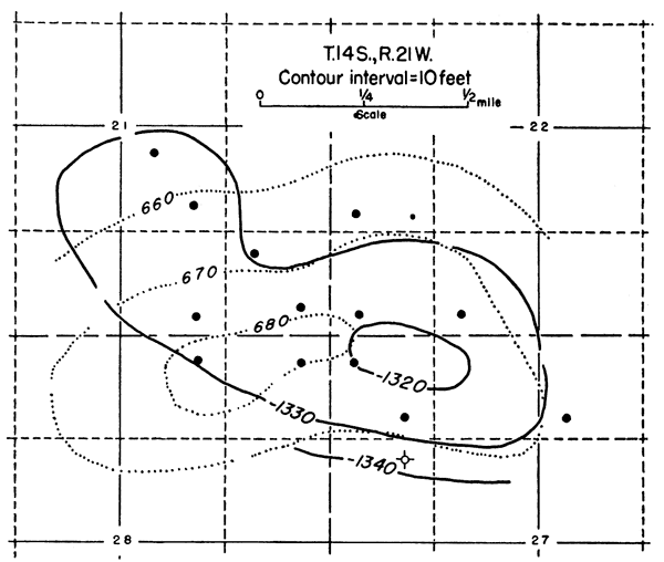
The Sunny Slope field, in Trego County in secs. 21, 22, 27, and 28, T. 14 S., R. 21 W., was discovered in 1952. Cumulative production was 119,235 barrels of oil at the end of 1953 from the Marmaton at a depth of 3,848 feet in the discovery well. The field covers an area of 640 acres; 1953 production was from 12 wells.
Structurally the field is situated in the Western Kansas basin just southwest of the western margin of the Central Kansas uplift. It occurs on a minor structural trend which parallels the uplift in a northwest-southeast direction and plunges northwestward (Lee and Merriam, 1954, pl. 1).
The structure on the Lansing (Fig. 10) reveals a northwest-southeast trending anticline with about 13 feet of closure. The southern margin of the field is vague because no wells have been drilled on this side. The structure on the Stone Corral is also a closed anticline but the crest is displaced to the west of the closure as shown on the Lansing. The closure on the Stone Corral seems to be about 14 feet although this is questionable because of the lack of information on the southwest flank of the anticline. The similarity of structure on the two horizons is slight, possibly due in part to lack of data toward the southwest, but both show closure in the general vicinity.
Figure 10--Structure map on top of the Stone Corral (dotted contours) and Lansing (solid contours) of the Sunny Slope oil field, Trego County, Kansas.
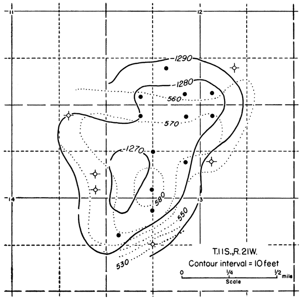
The Walz field, located in Trego County in secs. 12 and 13, T. 11 S., R. 21 W., was discovered in 1950. Cumulative production at the end of 1953 was 241,071 barrels of oil from the Lansing-Kansas City and Arbuckle at depths of 3,428 and 3,666 feet, respectively, in the discovery well. The field covers an area of 700 acres; 1953 production was from 11 wells.
Structurally the field is situated on the northern end of the Central Kansas uplift just south of a large broad synclinal area which separates the uplift from the Cambridge arch. The relation of the field to regional structure is similar to that of the Hayden and Law fields.
The structure on the Lansing (Fig. 11) shows an elongated anticline which trends in a northeast-southwest direction and which has about 10 feet of closure. The Stone Corral structure also trends northeast-southwest and has closure of about 16 feet. The two structures are almost identical in shape and structural relief although the Stone Corral crest is slightly east of the Lansing crest.
Figure 11--Structure map on top of the Stone Corral (dotted contours) and Lansing (solid contours) of the Walz oil field, Trego County, Kansas.
The Stone Corral structure reflects the Lansing structure with a reasonable degree of accuracy in western Kansas. This is shown by the close agreement of anticlinal structures on the Stone Corral and Lansing in 9 of the 10 fields which were studied. The one exception is the Sunny Slope field in Trego County and the lack of agreement of structure on the two horizons may be due to the lack of control. In most cases there is also a coincidence of the crests on the Stone Corral and the Lansing, although in the Sunny Slope field the crest on the Stone Corral is shifted to the west and in the Walz field it is shifted to the east. The shift of the crest in these fields amounts to less than half a mile.
The structures which occur in the Western Kansas basin (e.g. the Nunn field) and the Salina basin (e.g. the Ruggles field), in general, have less magnitude than those which occur on the Central Kansas uplift (e.g. the Hickman field). They in turn have less magnitude than the structures that occur in the vicinity of the Cambridge arch (e.g. the Adell field). This difference in magnitude is due partly to a different history of structural development and partly to location in relation to tectonic features. Thus, structures on the Cambridge arch would be steeper and more sharply defined than similar ones on the Central Kansas uplift because the Cambridge arch continued to develop after the Central Kansas uplift became quiescent. Structures that occur in the middle part of the basins should be of less magnitude than those on the flanks because they were farther from tectonically active areas and thus the formative forces.
In the area of the Central Kansas uplift it seems that some of the northeast-southwest structures (e.g. the Walz field) are sharper than those which trend in a northwest-southeast direction. As suggested by Lee and Merriam (1954, p. 20) these northeast-southwest trending folds, which parallel the Nemaha anticline, may still be developing. Also on the Central Kansas uplift and in the Western Kansas basin where the structural relief is lower, closed structures on the Lansing may not show closure on the Stone Corral, but may be reflected as an unclosed high developed on a plunging nose (e.g. the Hayden field). There is also less probability of coincidence of structure on the two horizons when the structural relief on the Lansing is small.
In general it can be stated that the structural relief on the Stone Corral is less than on the Lansing. Only two of the fields, Stuttgart and Walz, are exceptions. In the Stuttgart field the closure on the Stone Corral is almost 20 feet more than on the Lansing and in the Walz field it is only about 6 feet more. In the Adell field the closure on the Stone Corral is almost 40 feet less than on the Lansing; however, the difference in most of the fields is not quite that pronounced.
Glover, R. H. (1953) Seismograph pays off in Kansas: World Oil, vol. 137, no. 4, pp. 109-110, 112, 114, 116.
Landes, K. K., and Keroher, R. P. (1939) Geology and oil and gas resources of Logan, Gove, and Trego Counties, Kansas: Kansas Geol. Survey, Min. Res. Circ. 11, pp. 1-45. [available online]
Lee, Wallace, and Merriam, D. F. (1954) Preliminary study of the structure of western Kansas: Kansas Geol. Survey, Oil and Gas Investi. No. 11, Cross Secs. and Maps, pp. 1-23. [available online]
Merriam, D. F. (in press) Structural development of the Hugoton embayment: Proc. 4th Subsurface Geol. Symposium, Univ. of Oklahoma, Norman.
Merriam, D. F., and Atkinson, W. R. (1955) Tectonic history of the Cambridge arch in Kansas: Kansas Geol. Survey, Oil and Gas Investi. No. 13, in press. [available online]
Merriam, D. F., and Frye, J. C. (1954) Additional studies of the Cenozoic of western Kansas: Kansas Geol. Survey, Bull. 109, pt. 4, pp. 49-64. [available online]
Merriam, D. F., and Goebel, E. D. (1954) The geology of the Norton oil field, Norton County, Kansas: Kansas Geol. Survey, Bull. 109, pt. 9, pp. 125-152. [available online]
Moore, R. C., and others (1951) The Kansas rock column: Kansas Geol. Survey, Bull. 89, pp. 1-132. [available online]
Kansas Geological Survey, Geology
Placed on web Jan. 7, 2009; originally published in June 1955.
Comments to webadmin@kgs.ku.edu
The URL for this page is http://www.kgs.ku.edu/Publications/Bulletins/114_4/index.html