![]()
Prev Page--Glacial Debris || Next Page--Prospecting
Chapter IV—The Tertiary Area of Western Kansas
Before beginning a discussion of water conditions over the western part of Kansas it should be stated clearly and with emphasis that the mere geologic age of rock masses, or of areas, has nothing whatever to do with water conditions. It is true, however, and here is the main point, that rock masses of the same geologic age within a given area usually have substantially the same physical properties. From our present standpoint we care nothing for geologic age, as such. But since it has been found that the Tertiary and Pleistocene material of the West, hereafter for brevity referred to as Tertiary, is uniformly of a light, porous character, composed of sand and silt and gravel, these physical properties are always implied in the term Tertiary. Elsewhere, in many parts of the world Tertiary formations have entirely different physical properties, and hence could not play the role of water gatherers as they do in Kansas. Likewise, the Cretaceous shales of the West, which form an impervious floor underlying the Tertiary, are known to have certain particular physical properties here in Kansas, although elsewhere they may have very different properties and may serve poorly as a floor for water-bearing horizons. It is the physical properties of these formations of different ages that we must bear in mind. Their geologic names are used because we must have them designated in some way and these names will do as well as any others.
Many investigations of the water-bearing qualities of western Kansas Tertiary have been made by different people throughout the last 25 years. The first of special note was made under the direction of the U. S. Agricultural Department, with Col. E. S. Nettleton at the head of the investigations and W. W. Follet his chief engineer. These investigations covered a large area of the Great Plains throughout which water conditions are substantially the same. Their report is published in volume 4, part 2, Senate Executive Documents 41, 52d Congress, 1st session. These investigations resulted in much good, largely because they were the beginning of a correct understanding of the ground water of the West.
The term "underflow," now so widely used, as far as I can learn, was introduced by Judge J. W. Gregory, in 1889, then editor of the Garden City Sentinel, in which paper and in different eastern newspapers and magazines he published much regarding the general underflow of the Arkansas river valley and adjacent plains. The late Prof. Robert Hay was a member of the Nettleton commission and wrote a considerable part of their report. Also, in different places he published short articles upon the ground-water of the plains, all of which were beneficial. In the spring of 1895 the newly created Board of Irrigation Survey and Experiment began a series of investigations in the western part of the state, which resulted in the publication early in 1897 of a report consisting of 238 printed pages, with many maps and illustrations. In this report is an article contributed by the writer, the summing up of observations made during two field seasons with himself and from 9 to 12 assistants studying the Tertiary and Dakota groundwaters of the state. This was followed in 1897 by a 65-page pamphlet, known as Bulletin No. 6 of the Water Supply and Irrigation papers, U. S. Geological Survey, written by the present writer, describing a quadrangular area in western Kansas, one degree of latitude and one of longitude in extent, lying immediately north of the south line of the state and west of the 100th meridian [available online]. In 1903 a folio report, Professional Paper No. 32, was published by the U. S. Geological Survey, prepared by Mr. N. H. Darton, giving the geology and groundwater conditions of a large portion of the Great Plains, including the western two-thirds of Kansas [available online]. This valuable report has many maps and charts and an extended verbal description of water conditions in western Kansas, including the Tertiary underflow and the Dakota artesian water. In 1904 Dr. Charles Slichter and assistants made a series of interesting and instructive observations on the underflow water in the Arkansas River valley and adjacent areas in the vicinity of Garden City. The results of their work were published in Water Supply and Irrigation Paper No. 153, already referred to a number of times in this paper [available online]. Again, in 1908, Mr. Henry C. Wolff and assistants made similar investigations on the underflow of the South Fork of the Republican River near St. Francis, Cheyenne County, Kansas, the report of which constitutes a part of Water Supply Paper No. 258, U. S. Geological Survey [available online].
It would seem, therefore, that there has been a great abundance of investigation and publication upon the water conditions of the West. The present paper will summarize what has already been published, and tell it in a plain way so that it may be understood easily. Only a few new matters will be introduced in it.
The subject is plain and simple. We have a Cretaceous floor of substantially water-tight material, the upper surface of which is irregular, corrugated as it were, generally with ridges and valleys trending substantially east and west, but not always so. This floor in general is as regular as the surface of the ground now is. Doubtless in Pre-Tertiary time it had a more or less well-defined drainage system flowing over it before the Tertiary material was deposited, for the Tertiary material has been carried eastward by the streams from the Rocky Mountains. At present there is a mantle of Tertiary soils and gravels overlying this Cretaceous floor. I am tempted to say it has fallen like a snow, lightest to the east. This idea expresses its conditions better than anything to which I can compare it. As a matter of fact, however, since the close of Cretaceous time, the date when the Rocky Mountain area was lifted so as to force the drainage eastward, waters from the mountains and from local rainfalls have been flowing eastward and carrying with them debris from the Rocky Mountains.
All mountain masses decay under natures processes of rock disintegration. Part of the materials of decay are soluble and are carried away in solution. Other parts vary in texture, some being the finest of silt and soil, others sand, and others pebbles and gravel. The debris along the foothills of every mountain range is working its way down hill across adjacent plains. This is true the world over. Wherever one goes in mountainous countries one will find a mass of debris along the foothills. Water processess of transportation are such that the finest material will be carried the farthest. One can find fine sand and silt along the easternmost limits of the Kansas Tertiary, a little coarser material to the west, from which it is gradually graded until along the foot hills proper boulders weighing tons are common, This may be noticed at the present time along any of the streams. At Arkansas City the sand in the Arkansas river is moderately fine. Follow up stream to Coolidge and one finds sand and many pebbles and occasionally boulders 4 inches in diameter, and likewise all over the face of the country. I was much interested some years ago in Goodland by looking at a sand pile used in making concrete for ordinary construction. The sand was largely feldspar, and nearly half its volume was over one-eighth to one-fourth an inch in diameter. It had been gathered from one of the little streams near by, not the valley of any particular river. A hundred miles east such coarse sand would be difficult to find, excepting in the bottom part of a river flood plain.
We have, then, this Tertiary material carried eastward by rivers and scattered here and there all over the entire plains area. Probably many of these streams have entirely disappeared and others have changed their channels, so that the earliest Tertiary drainage does not now exist. But the general conditions were as they now are. Temporary lakes doubtless were formed here and there, beneath the quiet waters of which the finest of sediment was deposited. There is good reason for believing that the relative elevations of the Rocky Mountains have changed from time to time, so that at one time streams would have a greater velocity than at another, and thereby carry the coarser gravel farther east. Scarcely a well has been put down upon the great plains that did not find an occasional gravel bed of coarser material, and in turn it is overlaid by a more recent bed of fine material. This alternation between coarse and fine materials is important practically, because water is most abundant in the coarse material, and perhaps equally important because it gives us an insight into the actual history of Tertiary times when the velocity of flow in the several streams was lessened or heightened by mild periodic uplifts and depressions of the Rocky Mountain area.
The immediate surface of the Great Plains area at the present time owes its characteristic features quite largely to wind action, generally a north wind or a south wind, which has scattered the finer materials here and there crosswise of the drainage channels, filling and obliterating some of them and giving others an extra load of fine material to carry farther to the east. This wind action has leveled and smoothed and softened the sky line section of the entire area, so that as one looks across it now it presents a beautiful, although somewhat monotonous, scene of broad, level plains, so level that perspective gives them the appearance of rising toward the horizon in every direction. Hills and valleys are scarcely noticeable over a large part of the plains area. It is only the larger streams which have been able to carry away enough of this loose material to produce much of a valley, the lesser ones usually having their channels cut but 50 to 100 feet below the upland level.
The distance east to which Tertiary material has been carried varies greatly. Where the early Tertiary rivers were the largest probably the material has been carried the farthest, and the old Tertiary divides perhaps extend eastward the shortest distance. The most of the present streams in the plains rise east of the mountains and hence are very young. Such is the Kansas River with all its tributaries, the White Woman, Bear River and the Cimarron River, none of which have their rise in the mountains proper, and all of which in their present form are doubtless of recent geologic age. Some of these streams have cut their channels down through the Tertiary material so that their floors are now in the Cretaceous material. In places much Tertiary material has slipped down the hillsides into the valleys faster than the streams were able to carry it away so that an uncertain amount of Tertiary material is scattered over the valleys. Other streams have not yet cut their channels to the bottom of the Tertiary and therefore no Cretaceous rocks may be seen along them.
Water-Bearing Conditions
Water conditions here are in every respect similar to those already explained for the glaciated area in northeast Kansas, excepting that the great, broad Cretaceous floor underlying the Tertiary of the plains is more even and more regular and has a greater stretch of distance than the Carboniferous floor under the glacial debris of northeast Kansas. The underflow is rainfall which came east of the Rocky Mountain summit. A portion of this rainfall is carried away by surface streams, another part is carried away by evaporation, and a third part sinks into the ground and goes downward until it comes in contact with the impervious Cretaceous floor. Here its downward movement is checked, and it begins moving east with the slow, sluggish motion of water traveling through sands and clays. The general motion has been eastward, but it has been diverted to the northeast and southeast and in extreme cases to the north and south by local irregularities in the Cretaceous floor. The speed at which it travels varies with local conditions and is always dependent principally upon two factors—the inclination of the floor and the porosity of the material through which it flows. As already pointed out, Wolff found in the Republican River valley at St. Francis a maximum rate of movement of 56 feet per day and a minimum of 4 feet or less, the difference being due principally to the character of matter through which the water was flowing.
Many apparently anomalous conditions result from general conditions as above outlined. In earlier times more than at present, water conditions on the Great Plains seemed very hard to understand by the uninstructed. Here is a river valley with an abundance of ground water in its flood plain material; yonder is another river valley near by with a valley composed of shale or chalk beds and no water can be found in it. Probably in this latter case by climbing the divide a hundred, two hundred, or three hundred feet higher, well water in abundance is at hand. The old idea held by many that well water was more abundant in river valleys than upon uplands seemed abrogated and conditions seemed topsy turvy. To make matters worse, if possible, and less readily understood, it not infrequently happens that one of these lesser streams will have great pools of cool, fresh water almost entirely unaffected by rains or drouths. Many of them exist in the plains area and were a boon to cattle men in early days. All this is perplexing, but one is more confounded by traveling down stream to find that for many miles the bed of the stream is entirely dry. Quite frequently an abundance of spring water gushes forth where one would least expect to find it, such as the springs near Meade which feed Crooked Creek, or those along Rose Creek in Wallace County, and many others that might be mentioned.
Could the observer have seen all there is at hand, he would have seen that there is nothing mysterious about it. These variable conditions, puzzling as they appear at first, are readily understood, are in fact just what one would expect from the conditions above explained. If the channel of a modern stream has not been cut into the Tertiary deep enough to reach water level in the sand or gravel, as shown in figure 6, water could pass outwards into the cut from the general ground water. But if the stream has cut its channel to a depth below the water level, as shown in figure 7, no matter whether it has reached the Cretaceous floor or not, there will be a seepage along the banks from the ground water. If the porosity of the material should be uniform the seepage will be uniform and the springs scarcely noticeable. But such conditions are hard to find. A bed of clay, a mass of coarser or finer sand, or some other irregularity intensifies the seepage at one place at the expense of another, and a spring is the result. Farther down the stream where the channel has been cut far down into the Cretaceous floor, as shown in figure 9, leaving the base of the water level 100 feet or more up the hillside, the springs will be found at a corresponding altitude. A stream fulfilling the conditions of figure 6 will have no water in it except from the surface-water drainage, while the one corresponding to the conditions shown in figure 7 has an abundance of water along its course throughout the entire year. Still farther below, as shown in figure 8, with the source of the water supply far up on the hillside, it often happens that the stream has accumulated a mass of sand and gravel along its newly formed channel which absorbs and conceals from view the water flowing into it from the springs above. It is a most common observation along many of the Kansas streams to find that at certain places springs and pools of water abound equaling in quantity and quality those commonly found in more humid regions, while both up stream and down during the long summer months the whole valley seems to be as dry and destitute of water as a desert.
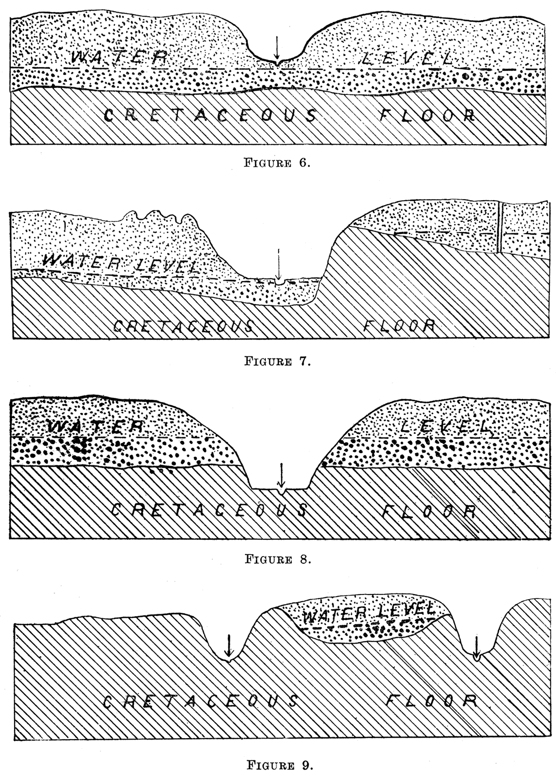
It sometimes happens that a shallow trough in the Cretaceous floor trends east and west. In such instances springs rarely occur along the side of the trough, but at the lower end they are very abundant. Of course it will not matter how high the Tertiary material is piled above the floor of the trough, as this has no bearing on the water question. A good example of this is the long Tertiary ridge between White Rock Creek on the south and the Republican River on the north in Jewell County. Here is a high Tertiary ridge extending nearly all the way along the north side of the county, under which Tertiary water is found in great quantity. At the eastern extremity of the ridge, where it passes down into the Republican River, springs of good, cold, pure water are abundant and strong. The cross-section, figure 9, and the Tertiary as shown on the geologic map, plate I, in connection with the hydrographic map, plate VI, tell the whole story.
In one other case, that shown in figure 9, no spring water can be found. Here a stream cuts into the Cretaceous floor at a place where the floor slants away from the stream, and of course the water drainage would be away from the stream.
Amount of Water in the Tertiary
The amount of water available for use throughout the Tertiary area varies greatly with the location. Broadly speaking, it is safe to say that it is unlimited, meaning thereby that there is no danger of the supply becoming exhausted through its use by man. This is quiet a different matter, however, from stating how much may be obtained from one individual well, or a group of wells. The wells supplying water for Newton are really the same as wells within the Tertiary, although lying beyond the extreme eastern border. Here it seems that the limit of water supply can not be found. If the wells now in use should prove to be insufficient for the demands, all that is necessary is to add other wells to the group. The same is true along the Arkansas River at various places where extensive pumping has been carried on.
It is generally believed that more water exists in the Arkansas River valley than can b~ found upon the uplands either north or south, yet it is probable that this belief is erroneous, at least in part. Going back to our fundamental conception of conditions governing ground-water, it will be remembered that the Cretaceous floor is more or less corrugated, the channels in general draining east and west, but locally in detail quite often varying from this. It will also be remembered that the source of the ground water is the rainfall on the eastern side of the Rocky Mountains and throughout the Great Plains area. Add to this the further fact, well established, that the ground-water moves eastward upon an average only a few feet per day, and we are forced to conclude that local rainfall is one of the main factors in replenishing the supply of water where large pumps are in operation. Local rainfall plus the eastward movement maintains the supply. Slichter found for Garden City that the water table sloped toward the river on the north from 10 to 14 miles, and that beyond this distance the water table slopes to the north and northeast, and the direction of flow is substantially the same (Dr. Charles Slichter, Water Supply and Irrigation Paper No. 153, page 7). In the Republican River in Cheyenne County, Wolff found that the direction of flow is substantially parallel with the general direction of the Republican River valley, which is to the northeast (Henry C. Wolff, Water Supply Paper No. 258, page 100). He also found that the underlying gravel is much coarser and cleaner along the middle of the valley than it is along the borders, which gives a maximum velocity of 56 feet per day through the coarser gravel and only about 4 feet per day along the borders of the valley where the sand is much finer and carries so much more fine silt.
With so many wells here and there more or less all over the uplands we are now able to report upon conditions in some places outside river valleys. At Scott City, where Mr. Lough has installed his large pumping plants, the coarse gravel is by no means universal. While sounding the water-bearing sand and gravel, in order to determine the best locations for his big wells, he found a number of places where the sand was so fine grained a well would scarcely be able to produce enough water to justify the installation of a large plant. Elsewhere within the water-bearing horizon he found beds of coarse gravel through which water could percolate rapidly and thus supply a well from which water was being pumped at a rapid rate.
These several illustrations I trust will be sufficient to convey a correct general idea. All over the plains area this Tertiary material rests directly upon an impervious Cretaceous floor. The floor is irregular in shape, with mild valleys and ridges. The material itself is quite variable in character, ranging from the finest silt and sand to coarse sand and gravel. Water in general is abundant, and so far as is known is liable to be just about as abundant in one part of the plains area as in another. In order to obtain the largest amount of water by pumping from wells proper soundings should be made in advance and wells should be located where the water table is farthest from the Cretaceous floor, that is, where the water-bearing material is thickest and coarsest. If one wishes a well for general farm use the character of material is of less importance because water will flow through fine sand into a well fast enough to supply an ordinary windmill pump and hundreds of head of live stock.
These are the broad general conditions, easily understood and easily tested. They are applicable over the entire plains area wherever the Tertiary material exists. Water is found practically everywhere, excepting in the few small areas where wrinkles lift the Cretaceous floor above the general level of the water table.
A great deal has been said and much concern manifested about the total amount of water this western area is capable of producing. From the foregoing we may draw the conclusion that for all practical purposes the amount is unlimited. This bulletin is written principally to help citizens all over the state to find water for domestic demands and for the livestock industry. It is not intended to be a treatise on irrigation.
It may be proper, however, to give a few figures on the amount of water which has been pumped from a few of the largest wells. It is reported that the Beet Sugar Company at Garden City have wells in the Arkansas river valley, and also on the uplands, which have maintained a flow of 2000 gallons per minute. The writer assisted in measuring the flow of two of the large wells belonging to Mr. Lough, near Scott City. These tests lasted for a period of 50 hours at each well and were very severe. The two results were practically identical, each well produced an average of 1090 gallons per minute for the entire 50 hours. In each case the sum total time the pumps were idle was carefully recorded. The stops made were short and not very frequent. In one case they totaled a little under 2 hours and in the other a few minutes over 2 hours. These are large quantities of water, so large in fact that one must figure a little to appreciate how large they are. If a well produces continuously 2000 gallons per minute, it will produce 2,880,000 gallons per day, an amount sufficient to supply the wants of an average city of 50,000 population, on the basis of 50 gallons of water per day for every man, woman and child. A well producing 1090 gallons per minute will produce 1,589,600 gallons per day, or enough to supply a city of between 31,000 and 32,000 population. If we assume that the average animal on the farm—cattle, horses, sheep, and hogs—will drink 20 gallons of water per day, then a well producing 2000 gallons per minute will supply water sufficient for 143,750 head of live stock, and one of Mr. Lough's wells would supply water enough to support 79,475 head of live stock. Of course these amounts are so great that they seem absurd, and yet they are results of actual tests. Still further, the writer knows that the Lough wells would have produced a much larger quantity of water had the machinery been sufficient to pump it. In each case the water in the well was lowered only ten feet, a condition assumed within about a half hour after the pump was started. The machinery was unable to force the water in the well any lower, although the water-bearing gravel was very much thicker. It has been shown in pumping tests that the rapidity with which water comes into a well from the surrounding sand and gravel is greatly increased by lowering the water in the well. The surface of the water becomes depressed, cone shaped, called the cone of depression. The more rapid the rate of pumping the sharper this depression becomes, and therefore the more nearly vertical the walls of the cone, all of which helps the water to flow into the well with ever-increasing velocity. It is quite probable, it seems to me, that the capacity of Mr. Lough's wells actually is double the capacity obtained when the tests were made.
In order to comprehend a little better what such a well means to the stock raiser we may look at it in another way. Under present conditions in the western part of the state a farmer rarely would keep more than 100 head of live stock on a square mile, with perhaps 200 head being the very maximum. This would give 20,000 head of live stock for an area 10 miles square. In order to consume all the water produced by such a well with 200 head of live stock per square mile we should have to use an area almost 25 miles square, while if we assume that one square mile of land will support 100 head of live stock, the area required to support enough live stock to drink all the water coming from one such well will be almost 34 miles square.
Prev Page--Glacial Debris || Next Page--Prospecting
Kansas Geological Survey, Geology
Placed on web June 9, 2017; originally published 1913.
Comments to webadmin@kgs.ku.edu
The URL for this page is http://www.kgs.ku.edu/Publications/Bulletins/1/04_tert.html