![]()
Prev Page--River Valleys || Next Page--Tertiary Area
Chapter III—Areas Covered with Glacial Debris
Geographical Extent
The northeastern corner of Kansas is covered with a mass of debris brought southward by glacial processes. In general the area is that portion of the state lying north of the Kansas River and east of the Blue River, although here and there glacial material has extended beyond these boundaries. Also, in portions of the area outlined, particularly along the southern and western boundaries, the debris is so thin that it has little, if any, effect upon ground-water conditions. Along the scarps and faces of steep bluffs it may be entirely wanting, and throughout practically all of Pottawatomie and Marshall counties it is so limited that it may be neglected in this discussion.
Character of Material
Materals composing the glacial debris are quite variable in character, but are principally sand and fine silt and loam producing the rich soil of the area. Here and there boulders or crystalline rocks abound, of various sizes. One lying about eight miles north of Topeka is 40 by 25 feet on the surface. Many of them may be found from 4 to 6 feet in diameter. From these large sizes they grade down to pebbles and gravel, with the smaller sizes being by far the most abundant.
Immediately preceding the glacial period the surface of this part of Kansas was covered with soil and local debris, as the surface is now outside the glacial area. Ice masses brought similar soil and debris southward from the north and to a very great extent scraped up the local soil and debris and mingled them with like materials from the north. It is hard to conceive of a more irregularly mixed mass of material than was thus produced.
These several materials in places are mixed together in a general way, producing the "till" of the geologist. Elsewhere they are more or less separated, with sand layers here, and clay layers there, etc. Sometimes the layers are approximately horizontal in position, having accumulated on the floors of temporary lakes produced by the melting of ice. Elsewhere they are inclined at various angles or curved in position as irregularly as one could well imagine. Frequently sand masses exist at the surface with clay beds underneath; or sand beds lie within different layers of clay. In general these conditions are the same throughout the entire glaciated area, but in detail they are so varied that it is hard to find any two quarter sections throughout which they are closely alike.
The glacial debris rests upon a floor of the stratified carboniferous rocks composed principally of shales and limestones. Finally, when the ice melted and an excess of surface water was produced many temporary lakes and river channels formed which long ago have gone out of existence. The finer grained and lighter materials were carried here and there to a varied extent and were deposited wherever they happened to be, the bedding planes of such materials conforming more or less with the surface of the ground.
Many of the old river channels were entirely filled with this glacial debris, and all the smaller, ones were, Subsequent erosion has produced a new drainage system. The lesser streams are located entirely independently of preglacial streams. The larger ones, the Missouri River and Kansas River, in most places are in their old channels, but have not yet succeeded in carrying away quite all the glacial material which filled them, so that along the bluff lines glacial deposits, variable in extent, are yet to be found.
The floor of stratified rock which underlies the glacial material, therefore, is exceedingly uneven, and consequently a set of conditions is established irregular in character, differing in detail within very narrow limits, thereby making a complete exposition of such conditions very difficult.
Water Conditions
The general principles of water accumulation already explained are here applicable just the same as with river alluvial material. The rainfall is copious and the run-off no larger, perhaps, than elsewhere. A portion of every rainfall sinks down into the ground and is drawn by gravity farther and farther until some obstacle to its downflow is encountered. The floor of stratified rock constitutes such an obstacle, because in most places it is limestone or shales. A few sandstone beds reaching the ancient surface and now covered by glacial debris, of course, will absorb all the water they can, and hold it or pass it on, depending upon whether or not a sufficient outlet exists. Naturally the upper surface of this floor will be as irregular as the surface of the country was at the beginning of glacial times. As already stated, numerous small streams have had their channels filled and not yet reopened. Valleys varying in width and depth were more than filled with glacial material and recent erosion has not rediscovered them. One can not predict where such old channels are excepting as they are discovered by soundings. To make a complete survey of the area so that all the irregularities of the shale floor could be pictured would require such an outlay of time and money that no one would ever recommend it. However, citizens of this part of the state should have correct ideas of actual conditions, so that in their search for water each one might for himself explore his own domains in an intelligent and economical way.
The amount of water accumulated in anyone place depends upon the amount of rainfall, thickness of surface materials, and the rate of migration or underflow. With so irregular an upper surface of the floor as we have in the glacial area the rate of travel or underflow of ground water will be exceedingly variable. In some places this floor is substantially level and but little water will be able to flow away and escape. Elsewhere, the floor may have a steep inclination and the flow of ground water may be relatively rapid, so that the accumulation of large quantities of ground water would be impossible. Again, glacial debris is so exceedingly heterogeneous we should not expect to find a broad continuous mass of water, sheet water, similar to that found beneath river flood plains. Here, a mass of impervious clay may rest immediately upon the floor, and there, a mass of similar clay may be immediately at the surface so as to greatly interfere with absorption of rain water. On the whole, however, glacial debris material is as thoroughly saturated with water as is river alluvium, so that here and there all over the uplands of the glaciated area water in great abundance can be found.
It is desirable again to emphasize the great irregularity in the character of the glacial debris. It is entirely possible that at one place a well might be put down to the shale floor and find no water, while within a hundred yards, or even a hundred feet, a well might strike a bed of sand lying below the general water table and therefore produce all the water desired. This utter irregularity of material makes a corresponding irregularity of ground-water conditions. It is strongly recommended that those in search of water be not discouraged by the first, second or third failure, should such failures come, but, with proper instruments, continue prospecting with a firm belief that sooner or later they will be rewarded. It is my best estimate that scarcely a quarter section of land can be found in the glaciated area of Kansas where the glacial debris is sufficiently heavy which does not have at least one place on it where water in abundance may be obtained.
A good illustration of this condition exists here at Lawrence. The glacial material reaches across the river southward into the Wakarusa valley and beyond. Just south of Lawrence the Southern Kansas Railway line, the Santa Fe, years ago had large wells to furnish a supply of water for the road. I was not here at the time the wells were dug and have not been able to learn details of the materials passed through. Water was found in abundance, which usually stood within a few feet of the surface. Bordering the right of way, Mr. L. Bullene owns a piece of pasture land. A well in the pasture close to the right of way now has water in it standing within a few feet of the surface. A windmill and pump supply water in abundance to a water tank for the live stock in the pasture. This well is only about 12 feet deep. It was dug so long ago that inquiry has failed to reveal the kind of material passed through, but quite probably the water is found in a bed of sand which rises to the east through a considerable catchment area. A number of other wells within a fourth of a mile of the Bullene well are only moderately satisfactory, and during the present dry summer have either failed entirely or almost so. Could we determine all subsurface conditions in this immediate vicinity, without doubt apparent anomalies could be explained quite readily.
It is not at all unusual in glaciated areas to find sand beds inclined to such an extent that good artesian flows are obtained, which are permanent or intermittent, depending on extent of catchment areas. Such wells are abundant in eastern Dakotas, Minnesota, and Iowa. Perhaps the most famous of these is an artesian well obtained at Belle Plaine, Iowa, in 1884. This particular well was a little farther down the hillside than others which had been drilled before it. In some way the water began flowing outside the well casing and in a short time had rifled a hole in the ground 3 or 4 feet in diameter from which a solid stream of water was flowing with sufficient force to lift the water column 3 feet above the surface. It brought out great quantities of sand, which threatened to cover up valuable town property in that vicinity. After a few months rampage it was brought into subjection by throwing into the opening hundred of carloads of rock. Prof. T. C. Chamberlain of Chicago University visited it and reported upon it (Prof. T. C. Chamberlain, The Belle Plaine Artesian Well, Science (I), vol. VIII. pp. 276-277, 1886). According to his estimation the entire source of water was rainfall upon a catchment area lying to the west and north not exceeding a mile square.
We have no specially famous or notorious wells in the glaciated areas of Kansas, but in general the area is well watered for domestic supply, and all natural conditions indicate that with proper and intelligent prospecting, based upon the general conditions above outlined, water in sufficient abundance may be had to supply all the needs of farmers and stock raisers and municipalities, no matter how protracted the drouth may be.
Additional Areas
Here and there all over the eastern half of Kansas may be found lesser areas throughout which general geologic conditions are substantially the same as those already described, either for river flood plains or for the glaciated areas. The fundamental principles controlling water conditions are the same in each of these two cases. If, now, we have a lesser stream than those mentioned in chapter II, such as the Wakarusa, or Grouse Creek, or many others, an examination will reveal conditions the same in quality as those described for the larger streams. With an encyclopedic article being written on the subject everyone of these lesser streams, even to the ravines not more than half a mile in length, would be listed. Of course this would be unnecessary work and expense. The intelligent citizens of Kansas having once understood the fundamental principles of the geology of ground water can apply them for themselves in whatever parts of the state they chance to live.
During the present summer farmers along the Wakarusa, a stream only about 40 miles long, did not suffer at all for want of water. Many wells have been examined and diligent inquiry made; with the same results; water in abundance. The Wakarusa did not go entirely dry, although there was a period of about 3 months throughout which not a drop of water entered it from surface flows. Pools of abundant stock water were found here and there throughout its course which were maintained by seeps from the ground water. This shows conclusively that the water table throughout the flood plain material of the valley was not reduced to a level below the surface of the water in the pools. Therefore, whenever the bottom of the pool was not below the water table, water in abundance could be had from such pools.
It should be remembered that it is impossible for all of the ground water of a valley two or more miles in width to seep into the river channel within three months' time, no matter how dry the weather may be. If we take the maximum average speed for any place yet mentioned in Kansas, the 17 feet per day of the Republican River valley at St. Francis, a simple computation will show that more than 300 days would be required for water a mile back from the river to seep into the river channel. Instead of the 17 feet per day probably the maximum speed would be only 3 or 4 feet per day, since the inclination of the water table throughout the valley towards the stream channel rarely is more than 2 feet per mile, and frequently not more than one foot per mile. With a water table so nearly level the seepage would be correspondingly slow. With a river valley flood plain 2 miles wide thoroughly saturated with water it is doubtful if all this water would seep into the stream within a period of 2 years continuous drouth. Due to those conditions usually obtaining in the valleys of eastern Kansas, the bottom of the present channel being away above the bottom of the flood plain material, it will be seen that it is impossible for all the water ever to seep into the present river channel. Therefore, as has already been pointed out in discussing river conditions, a stream might go entirely dry during a protracted drouth and yet water might be obtained from wells in many places in the river valleys.
Along the smallest of tributaries it often happens that a large amount of debris or "slip" accumulates in a mass from 10 to 40 or 50 feet thick having slipped down from the escarpment or bluffs on either side. Such places as these are excellent for producing water. A good illustration of this kind may be found at Lawrence in the little ravine leading north from the University campus through Marvin Grove and McCook Athletic Field. A narrow ridge of shale bounds this little valley upon the east, the ridge extending north beyond "North College" a distance of about five-eighths of a mile. On the west likewise is a hill of Coal Measure shale forming an impervious floor. The water shed of this valley is about three-eighths of a mile wide by five-eighths of a mile long, or a total of a little less than 160 acres. This catchment area holds rainfall so that wells situated along the northern end of the valley have an abundance of water, no matter how dry the weather, and in wet weather stand almost full of water.
All eastern Kansas is cut into ridges and valleys, the lesser upper tributaries being like unto the sands of the sea in number. It will not do to say that everyone of them will furnish water in dry weather, but doubtless more than half of them would, were proper search made in the right places. I am acquainted with different parts of the state from which live stock was rushed to market late in August this year on account of a scarcity of stock water, and I have many reasons for believing diligent search would have found a great abundance of water in the very pasture from which stock was shipped. He who would prospect for water should get clearly into his mind that this loose material permits rain water to soak down into it, and if in the years that have passed rains have been sufficiently copious, it has filled underground valleys, large or small, with water, where it now awaits an intelligent search by man.
Assuming that all the foregoing is correct, we are now ready to examine the hillsides and the sides of escarpments to determine whether or not conditions are favorable for supplying ground water. Secular disintegration of rock masses is all the time furnishing debris, or waste material. The more soluble of these pass into solution and ultimately find their way to the ocean through seeps and springs. The less soluble accumulate on the hillside and gradually work their way down hill to the valleys below, although this movement of debris is so slow it is rarely observed by the ordinary citizen. This debris resting on the hillside absorbs rain water the same as loose material will anywhere else. The un decomposed rock beneath constitutes a more or less impervious floor, so that here we have the same conditions already described for all kinds of river valleys and for general surface throughout the glaciated area where water is so abundant. Therefore, according to the principles so proclaimed, we should find water along such hillsides in greater or lesser abundance, depending upon the detailed conditions obtaining. Many hundreds of wells In Kansas obtain their water from just such areas and quite frequently springs of great value burst from the foot of debris-covered hillsides.
In eastern Kansas the hill tops are usually covered with hard rock, most generally limestone. The bluffs, therefore, are steep near the summits, frequently being precipitous. Down below, however, the steeply inclined surface merges into one of milder incline, the lower portion gradually joining the level floor below. Abundance of water along such places must depend upon the rainfall, the thickness of the water-bearing debris and the shape of the shale floor beneath. When all these conditions are favorable large and permanent supplies of water may be found.
In 1896 the writer made an investigation of certain portions of the state for the U. S. Geological Survey, report upon which was published and constitutes Bulletin No. 6 of Water Supply and Irrigation Papers [1897, available online]. In that report, after giving a general discussion of conditions favorable for ground water, an illustration was taken from Lawrence, from the account of which a short quotation is here made:
"A good illustration of this latter condition is found near the University of Kansas, at Lawrence. In 1893 the University authorities decided to own their own water supply. An investigation was therefore made to ascertain whether a sufficient supply could be had within a reasonable distance of the buildings. It was found that on the south side of the hill a large amount of debris produced by the decomposition of the limestone and shales of the hill had accumulated on the hillside, and that it was well charged with water. Figure 5, drawn to scale (figure 5 of this report), shows the conditions. The hill is composed principally of a fine-grained impervious shale, with a limestone mass A on top. At the boiler house, 300 feet south of the brow of the hill, the debris was found to be 40 feet deep. A well dug here B, during the driest part of a dry year, showed the amount of water was not very considerable. At points farther down the hillside the water was more abundant. Finally, a large well was put down at the point C, 1000 feet south of the brow of the hill, and galleries about 6 feet in height were run both east and west just on top of the un decomposed shale, to intercept the water as it moved down the slope and drain it into the well.
Figure 5—showing general geologic and ground-water conditions on the hillsides at the University campus, Lawrence, Kan. The hilltop is covered with a limestone, below which the entire hill is composed of shale. Debris gathers on the hillside to variable thicknesses and absorbs rain water, which gradually creeps down the inclined shale floor. Wells at B and C supply water in dry weather.
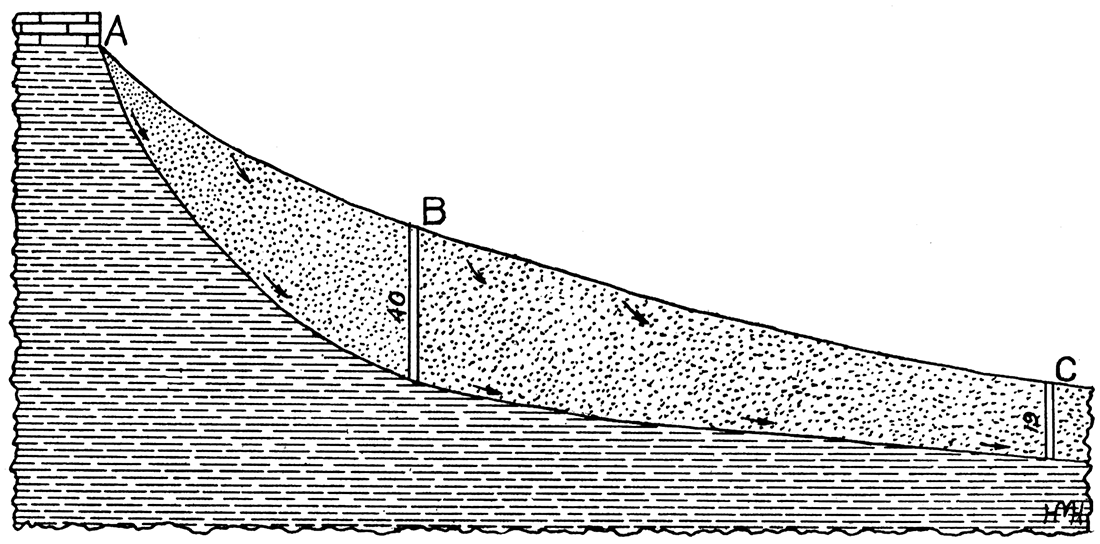
"It was reasoned that this greater distance from the summit of the hill was necessary because the gathering area above the boiler house was so limited that an insufficient amount of water would be obtained at that point, but that with the added distance to where the well was finally located a gathering area of sufficient extent was passed, considering that the average rainfall at Lawrence is a little more than 35 inches annually. Southward the thickness of the debris gradually decreases, so that a mile away it is only an ordinary soil above the undecomposed shale. Were the debris a mass of coarse sand, similar to that so often found in the western part of the state, without doubt the water would soon all run down the hillside and appear as springs in many places; but the debris from a mass of shale is principally clay, which lets the water through it very slowly, and therefore its southward movement is so slow that little reaches the extreme southern limit of the debris. Yet in the vicinity of the well a water supply is found sufficient to produce 5000 gallons a day almost all the year, and 10,000 in wet weather, an amount which could be increased indefinitely by extending the east-west galleries.
"Here we have a good illustration of the underground water plane having a very concave surface facing upward. Instead of the water lying in the form of an underground lake, with a level surface, it is a mass of water held in the clay in such a manner that its upper surface is nearly parallel with the highly inclined surface of the ground. We may speak of the clay within the body of water as being more than saturated, using the term saturated to mean holding a water content just equal to the largest amount the clay can hold without being compelled to give up a part of it whenever an opening is made into it. When the clay is in this condition and more water is added to it, this extra amount will run out into the opening made.
"As the well at the point C was being dug it was noticed that the clay was moist almost from the surface, but that no water came into the well until it had reached to within about 6 feet of the undecomposed shale. Here the point of saturation was reached, and any greater depth passed clay which was more than saturated, that is, had more water within it than it could hold back from running into the well. This extra amount in excess of saturation is the available water in all cases. It is that which has an underground movement, and which is available in so many parts of the world as supply for man."
It might be added that on this particular occasion the narrow valley on the north, in which the ball park of McCook Field is located, was looked upon as a favorable location for a large supply of water because it was hemmed in on all sides, so to speak, and hence the water was concentrated along the shale floor. But fear was expressed by health officers lest the quality of water to the north was not what it should be, while to the south no sources of pollution existed. It might be added that the autumn of 1893, when this volume of 5000 gallons of water per day was obtained, was generally considered a moderately dry time.
Only a few years ago almost every resident along the eastern slope of the ridge to the west of Lawrence, that is, between Massachusetts street and Oread avenue, had a well in his back yard. Water was found in sufficient quantities to supply all demands for domestic use, and dry weather conditions lasting for a few months or half a year had but little effect on such wells. Farther east, away from the slope of the hill, well water was not so easily found. Of course the mere fact that this hillside is now situated within the limits of a corporate city has nothing to do with its abundance of ground water. Therefore, we may use this illustration as a type of water conditions which we have a reasonable right to expect along every similar hillside where climatic conditions are the same. It is the combination of rainfall, absorbing power of the debris, and the shale floor beneath which provides the water.
I have traveled all over Kansas, and in general, particularly throughout the eastern half of the state, I know from personal observation that a large proportional part of the land lying outside the river valleys and south of the glaciated areas has many similar conditions to those described in and around Lawrence. Therefore I have great confidence in my belief that few areas as large as a mile square can be found which would not produce water in dry weather were wells properly located and dug to a proper depth.
Prev Page--River Valleys || Next Page--Tertiary Area
Kansas Geological Survey, Geology
Placed on web June 9, 2017; originally published 1913.
Comments to webadmin@kgs.ku.edu
The URL for this page is http://www.kgs.ku.edu/Publications/Bulletins/1/03_glac.html