![]()
Prev Page--Contents || Next Page--River Valleys
Chapter I—General Considerations
In order to give an intelligent and understandable discussion of the ground water of Kansas a few fundamental principles should be reviewed. Contrary to popular belief, there is nothing whatever mysterious connected with the entire subject. Ever since the earliest dawn of history we have been dominated, to a greater or less extent, by a belief that there is something mysterious, supernatural, unknowable, about the existence of ground water, and that therefore something more than ordinary intelligence should be called into action when searching for it. Hence the "open sesame" has been more or less everywhere in demand, and is yet, probably, with a majority of people.
I have no doubt that could the question be settled by a vote of the people, as we settle important matters of politics and religion, the vote would be overwhelmingly in favor of the wizard's wand in one form or another. Just last week I visited a well supplying a large amount of good, wholesome water and was told by the owner that he located it with the forked stick, that the well driller did not believe in such a method, but that after the abundant supply of good water was obtained the driller became thoroughly converted to the efficacy of a forked peach-tree limb, and this in face of the fact that almost every neighbor within a radius of three miles, and in some directions from five to ten miles, had an equally good well obtained in the same manner and practically at the same depth, by drilling through the same kinds of rock into the same porous stratum, showing he was in an area underlaid by sheet water substantially everywhere present.
I beg the reader, therefore, to lay aside all his prejudice, If he has any, and ideas of mysteriousness of ground water, and believe with me that there is nothing mysterious connected with the subject; that water underground obeys the same laws that it does above ground; that above ground, in ponds and rivers and lakes and reservoirs and city supply pipes, it is controlled by the power of gravitation, and that likewise water beneath the surface of the ground is controlled by gravitation; that it flows here and there wherever gravity pulls it; that it is held here and there by impervious rock masses, as it is in the bottom of streams and lakes and water tanks; that pressure is set up whenever subsurface conditions are such that a "head" can be produced, as it can in water pipes, water towers, elevated tanks, etc.; and that the wizard's wand, the open sesame, has no more to do with ground-water supply than it has with water supply in lakes, ponds, pipes and other artificial containers on the surface.
It is now desirable to give a brief explanation of the terms "porous" and "impervious," and to show why water may be available from some rocks and not from others. All rocks are porous, and all rocks may contain water. But with some of them the water is entirely unavailable, and with others it is easily obtained. Some rocks may be full of water, but when a hole is drilled into them no water will run into the hole. Other rocks may be full of water and when a hole is drilled into them the water collects in the hole and may be pumped out. Now why this difference? Here is the explanation.
Adhesion is the name by which we express the attraction, or pull, the surface of a solid may have for a liquid in contact with it. Adhesion seems to be the same per unit of surface for all forms of the same solid, regardless of size of the granules. I mean, for example, that adhesion is as great on the surface of a little grain of sand as it is on a big one, so that when a little grain of sand is wet with water it holds the water to its surface as tightly as it does on the surface of a big grain. In this respect it differs from gravity, for gravity varies as the volume of the same kind of materials. Now, whenever water will wet the surface of a solid we have adhesive force greater than gravity. For gravity is all the time pulling at the water which does the wetting in an effort to pull it away from the surface, but adhesion holds onto it and will not let it go.
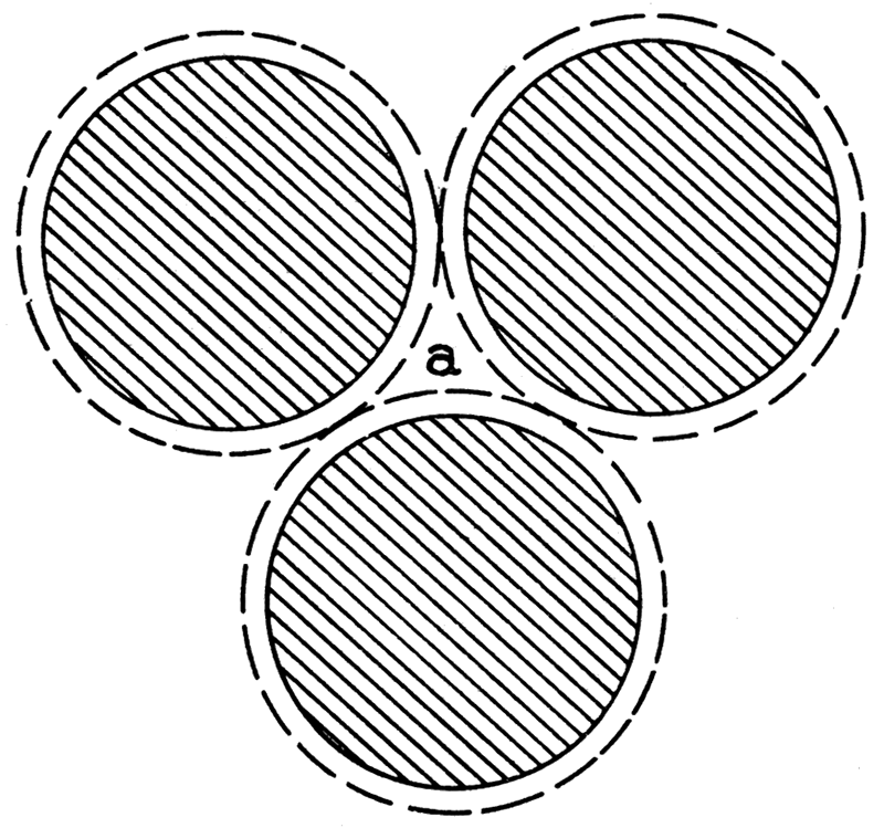
The force of adhesion, like so many other forces, varies as the square of the distance. This means that a particle of water one-millionth of an inch from the surface of the sand grain is held with a certain force, while a similar particle of water two-millionths of an inch away is held with only a fourth the pull. But gravity gives a constant pull on each particle of water, so that it gets all the water that is not too close to the sand grains, as shown in figure 1, placed as sand grains are in a pile of sand or in a sand rock. Let the broken line around each represent the distance from the surface throughout which adhesion is more powerful than gravity. Water will wet the three grains, therefore, and will crawl all over each in spite of gravity. But the water in the center of the void, at a, between the three grains is so far from the surface of each grain that gravity acts on it more powerfully than adhesion does, and therefore will pull it away when opportunity offers, in spite of adhesion, but it will leave a film of water covering the surface of each grain of sand.
Figure 1—representing sand grains wet with water. The broken line around each grain represents the distance from the grain throughout which adhesion surpasses gravity and holds the water to the sand grain in spite of gravity. Beyond the broken line within the area marked "a," gravity surpasses adhesion, and water here may be pulled away by gravity. Rocks of this character are called "pervious."
Now, let us suppose we have a sand rock composed of grains of sand like those just mentioned. We may have two conditions with different results. If the amount of water present is small, adhesion may use all of it in covering each grain of sand with a film shown by the broken lines around each grain in figure 1. In this case there will be no water left to fill the centers of the voids, and therefore none that may be pulled away by gravity. We may drill a hole into such rock, but no water will run into the hole, so of course we can pump none out. And yet we are dealing with a rock that may become very productive. Let us suppose that in a second case water is more abundant, as much as can be forced into the rock. Now, gravity has a chance to control all the water in the voids outside the broken lines in figure 1. It will pull it into a hole, if we drill one into the rock, and we may pump it out. It will pull it down hill if the rock is inclined, and make the water flow through the rock as it would in a river, only slower. It will give the water a pressure or "head" if it is properly held in the porous rock by impervious layers above and below, and we may have an artesian well if we bore a hole down into it.
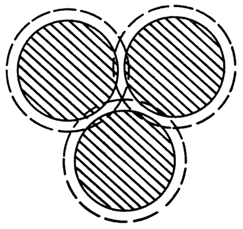
Let us consider another case in which the sand grains are exceedingly small. Figure 2 may be used to help us. Here are three grains of sand so small that the broken lines surrounding them cut each other in the center of the void between the grains, leaving no space whatever where water may exist which may be pulled away by gravity. Suppose this rock is full of water and we drill a hole into it. No water will run into the hole because all of it is held on the surface of the sand grains by adhesion.
Figure 2—representing how granules may be so small that gravity can not pull water away from their surfaces, and thus such granules constitute a rock that can not become a water producer, and therefore it is "impervious" to water.
It is not a question of how much water a rock may have within it, therefore, which interests us, but how much can we get out of it. Fine-grained rocks and coarse-grained rocks have about the same per cent of voids. Some very fine-grained soils carry around 50 per cent of moisture. Coarse-grained rocks yield more water than fine-grained rocks do entirely because the voids between the grains are so big a portion of the water is subject to the influence of gravity. We use the term "impervious" to express the thought that no material may enter and pass through the rock mass talked of. Strictly speaking, as will be seen from the above explanation, no rock can be impervious, because all rocks have voids in them. In everyday use the term impervious means that the rock is so fine grained adhesion holds all the water which gets into it. The conditions are as shown in figure 2. A pervious rock, on the other hand, is a rock sufficiently coarse grained so that water filling the voids is partly outside the controlling influence of adhesion and therefore subject to the pull of gravity, as shown on figure 1.
Rate of Flow of Ground Water
The rate of flow of ground water through porous material is exceedingly variable and depends upon two conditions: First, the inclination of the top surface of the ground water, which is called the "water table"; and, second, the size of pores or voids within the material. It is evident that where more resistance is offered to movement the inclination of the water table may be greater. Water in a lake or river has its surface, or water table, substantially level. If a stream has a fall of a foot to a mile an appreciable current, or velocity, is given the water in the stream through the influence of gravity. If the water lies imbedded within a mass of earthy material, the water will flow down stream with a velocity just as it does in an ordinary river, only the hindrance afforded by the earthy material through which it flows makes it flow slower. The coarser such materials, and the larger the voids within, the more rapidly water will flow through them. A pile of rock boulders averaging six inches in diameter will permit a velocity of water through them somewhat approaching the velocity within ordinary streams, and will also be dependent largely upon the inclination of the water table, i. e. the water surface within the mass of boulders. Should the material gradually grow finer, passing through various grades of coarse and fine pebbles and then to coarse and fine sand and silt, and finally to fine-grained and compact clay, the velocity through the material will vary accordingly and continuously grow less until it becomes practically zero in well-compacted clay.
In 1904, Doctor Slichter made tests to determine the flow of ground water in the river valley at Garden City. Here the surface of the river flood plain slopes down stream about seven feet to the mile, and the water table slopes about the same, as is shown from the fact that water is found at substantially the same depth up and down the valley near Garden City. The summing up of his results gave an average flow down stream of about eight feet in twenty-four hours. In many places in the state where sheet water is found the water table has a much greater inclination, and flow is correspondingly more rapid.
In the summer of 1908, Mr. H. C. Wolff, of the U. S. Geological Survey, made an investigation of the underflow in the south fork of the Republican River, near St. Francis (Mr. Henry C. Wolff, U.S.G.S. Water Supply Papers 258, page 119, Washington, 1911). He found that the flood plain area and the water table had a slope of 10.7 feet per mile, and that the ground water moved down stream at an average rate of 17 feet per day, and a maximum rate of 56 feet per day in the coarsest sand and gravel. Should the inclination of the water table be increased it is evident the velocity of flow would be correspondingly increased.
Porous Surface Materials Resting on an Impervious Floor
According to the foregoing explanations of the action of water within porous material it follows that when rain water falls upon the surface of the ground a portion of it will sink into the ground and will be pulled downward by gravity. We have a right to assume that should nothing intervene to prevent, ultimately this rain water would reach the center of the earth. But the outer portions of the earth are so complex that divers conditions obtain, here and there, which retard or altogether stop, the downward movement, of water.
We have explored the earth down, to a distance of something over 6000 feet, in a few places, to which depth we have sunk drill holes, and to something over 5000 feet by sinking shafts and having men go below and operate mines. Usually, the deeper one goes the more abundant and more troublesome the ground water down to a certain depth, which varies greatly at different places, but which upon the average is from 3000 to 4000 feet deep. Beyond these depths water occurs less in quantity and in some places is not present in sufficient quantity to cause trouble in mining.
A careful study of local conditions in each mining area generally will reveal conditions which control the depth at which water may be found. Not infrequently a shaft will pass through different formations alternating wet and dry, showing that it is not so much a question of depth as it is one of structure or texture of rock masses which control ground-water conditions. For example, in sinking the shaft for the salt mine at Lyons, Kan., water was found near the surface; which increased in abundance to a depth of substantially 300 feet, at which depth water was very abundant. It seems that nearly all the material passed through thus far was porous and would let gravity pull the water downward with ease. Here a mass of fine-grained, compact, impervious shale was reached which served as a floor to the water, so that it could sink no further. Salt is mined here a depth of 1000 to 1030 feet, and no water whatever is found in the mine.
At Kanopolis, about twenty-five miles to the north, shafts are also put down through similar surface materials to the underlying salt beds. Conditions here are quite like those at Lyons, excepting that the overlying fine-grained shales have more fissures and crevices in them through which water can slowly work its way. The result is that salt mines here are somewhat bothered with water, although not badly so. We can well imagine a still further change by assuming that some other place could be found where the shale beds are fissured and broken to such an extent that water would work its way through them very readily.
A Porous Bed Between Two Impervious Beds
We often have a porous rock layer resting on an impervious bed and also covered by an impervious bed. Under such conditions water always deports itself strictly in accordance with the laws of gravity. If nature has supplied no opportunity for water to get into the porous rock, then, of course, it will contain none. Such conditions are exceedingly rare, and yet are met with occasionally in drilling deep wells for oil, and gas or other purposes. In a few instances in the oil fields of western Arkansas and eastern Oklahoma drillers report finding dry sand rock hundreds of feet beneath the surface, with water-tight beds of shale both above and below. Similar conditions occasionally are reported from the California oil fields. Usually, however, deeply lying sand rocks are filled with water wherever found.
Such a mass of sand rock surrounded above and below with water-tight shales may be compared to a surface water-pipe flattened out so as to cover a wide area. Water will comport itself within such sand rock as it would within a water pipe, excepting that velocity of movement will be greatly reduced and will be comparable, to the velocity of movement already discussed for water within surface sand masses. In most cases such sand rocks come to the surface at least along one margin, so that rainfall may supply them with water. The rock itself does not have to come entirely to the surface, and in fact rarely does. If it underlies a mass of porous, material such as soil, sand, or gravel, which in turn is exposed to the surface, then rain water will have an opportunity to work its way down into the porous rock and in between the impervious layers above and below. The areas where rain water enters such rock masses are called "catchment" areas and are important in all considerations of ground water. Catchment areas may be very limited, or very wide. In considering the amount of water which may be furnished by deep-seated porous rocks the extent of the catchment area and the rainfall upon it are of great importance.
We now have the water started downwards in our porous rock which is surrounded above and below by impervious masses. A number of different conditions may obtain. The end or side of the pervious rock, or catchment area, may be exposed to the surface, or it may not. The great Dakota sandstone formation of America has its western area exposed along the foot of the Rocky Mountains from southwards in Mexico far north into Alberta, Canada. This forms a catchment area, therefore, which is a long narrow strip of country crossed by myriads of greater or lesser mountain streams that carry water from rains and melted snows from the entire eastern slope of the Rocky Mountains. A large amount of such water is absorbed by the Dakota sandstone mass along this long ribbon-like catchment area, the elevation of which in the United States averages from five to six thousand feet above sea level. Eastward the sandstones dip faster than the surface and become buried from one to two thousand feet by overlying rocks. Still farther east the dip grows less, so that the surface inclination catches up with it and causes the same Dakota sandstone to outcrop where the elevation is from fifteen hundred to two thousand feet.
Such a condition affords excellent opportunity for the water content from the catchment area to work its way eastward and to escape as spring water where the same rock masses are exposed to the surface. If the escape is sufficiently rapid, it is evident little or no water pressure will be set up within the sandstone because it goes out as fast as it comes in. But if the outflow is checked, or entirely stopped, and the intake is copious, sooner or later the entire rock mass will be full of water and a pressure, or head, will be set up so that when a hole is drilled down into the rock an artesian flow results. Experience shows that all these matters turn out just as we have a right to expect they would, the water being propelled down hill or down stream by gravity just as it is on the surface of the ground.
If our porous rock mass has a sufficient catchment area, but has no outlet lower down, as is often the case, then water can not flow through it. It will flow into it, however, and fill the voids throughout its entire area, and there it will stand. If a stream cuts a channel down into it, seeps and springs result. If a well is drilled into it, artesian water will be obtained. But otherwise the water will remain in the porous rock without having an opportunity to flow out of it.
In many cases substantially the same results are obtained when the rock mass is not very porous, such as ordinary limestone. Limestones invariably are in layers one above another, and more or less space exists between these layers. For convenience we call such spaces bedding planes. They may be filled wholly or partly with clay and therefore the amount of water which could flow down them would vary from place to place in the same rock masses. Limestones generally have vertical fissures, or cracks, in them substantially at right angles to the bedding planes. These cracks, likewise, are variably filled with clay, and hence will have a flow of water through them differing in different places. Suppose we have such a mass of limestone inclined in any given direction, situated so that a catchment area exists in the humid part of the country. Rain water would work its way down from the catchment area into the vertical fissures and from them into the spaces between the rock layers, and would follow the bedding planes downward in the direction of the inclination of the rock masses. Substantially similar conditions would exist here as explained for the more porous sand rock sandwiched between fine-grained, impervious shales.
On Mineral Waters
Nothing mysterious should be expected in attempting to understand mineral waters. Rain water is substantially free from mineral material, although rarely entirely so. Raindrops are formed in the atmosphere and consequently constitute the purest natural water known to man. Such pure water has a wonderfully strong dissolving power. The atmosphere contains a variable amount of soluble mineral material in the form of fine dust, usually of microscopic dimensions. As soon as a little raindrop comes in contact with the dust particles it begins dissolving them, and in that way the purest of rain water contains a trace of mineral material. Of course rain water always contains portions of the atmosphere, for water holds or dissolves portions of the gases constituting the atmosphere. It has been estimated that rain water before lighting upon the earth never has less than two parts to the million of mineral matter dissolved in it and sometimes as high as ten parts (Richards and Woodman, Air, Water and Food, page 197).
When rain water comes in contact with the ground it immediately begins dissolving the ground itself. Naturally, materials easily dissolved will be dissolved in greatest abundance. When rain water falls upon granite rock or pure sandstone it can dissolve but little, and consequently river water and lake water in granitic and sandy areas will have but little material dissolved in them. But if rain water falls on other earth materials more easily dissolved it will dissolve a larger amount. Limestone is quite soluble in water containing carbonic acid gas in solution. Rain water dissolves this gas from the atmosphere and also takes up large quantities of it from decaying vegetation at and near the surface of the ground. As the water travels far beneath the surface it tends to lose its capacity to dissolve limestone because the carbonic acid gas has been used up. Well water, spring water, and river water in limestone countries, therefore, contain a large amount of lime held in solution.
Stratified rocks quite often contain gypsum and salt, each of which is easily soluble in ground water, and therefore such water is salty or gypsiferous as the case may be. Our stratified rocks were formed partly under ocean water and the sediment forming them was saturated with ocean water, just as sand on ocean beaches and mud and other sediments now constituting the delta of the Mississippi and other rivers are at the present time. Ocean salts dissolved in ocean water will remain in such materials until leached out by rain water. If, now, we have a mass of porous rock with a good outlet or subdrainage, as already mentioned in the Dakota sandstone in Kansas, various soluble materials held in them will have been leached long ago so that the water obtained from such sand rocks at the present time will be comparatively pure. Porous rocks which do not have this subdrainage will have had no chance for the ocean salts to be leached out and consequently may produce water which is substantially the same as ocean water, or even more concentrated. It so happens that the most of our sand rocks reached by the drill in our oil and gas fields of southeast Kansas belong to this latter class, namely, rocks which have no subdrainage. That is the reason why water obtained by such drilling invariably is salt water. A chemical analysis of this water shows that it contains not only salt, but practically every other material found in ocean water. Water produced by such wells is largely the same over wide areas of country although differing sightly in detailed properties.
Later in this volume it will be shown that throughout large portions of Kansas the rock masses rise to the east and dip to the west, thus affording a suitable catchment area on the east. However, they have no outlet for drainage to the west and therefore ocean salts originally in them have not been leached and carried away. This gives us salt water in almost all of our deep wells over a large portion of the state. It should be noted that water obtained from rocks near the catchment area usually is relatively pure. This is just as one might expect. Experience has shown that wells drilled into water-bearing rocks near the catchment area produce good water, and that as we migrate down the dip slopes away from the catchment area, and further from the surface the water accordingly becomes more highly mineralized until ultimately it is unfit for use. Some of the best-watered portions of the state are in just such conditions, along slender zones lying parallel with catchment areas throughout which the water is but slightly mineralized.
Application
In applying the general principles above outlined to the conditions of Kansas, in order that they may be used in a prophetic way for the purpose of locating areas throughout which it may be possible to obtain well water, one must know the general geology of the state. This is geology, pure and simple. Searching for ground water is comparable to searching for other mineral materials, and geology is just as applicable as it is in searching for coal, or oil, or gas, or metallic deposits.
We have seen that geologic conditions may be divided into two great classes; first, conditions where the porous material comes immediately to the surface and rests upon an impervious floor; second, where porous material comes to the surface through a part of its existence, producing a catchment area, and elsewhere becomes imbedded between nonporous materials. These two conditions should be kept clearly in mind. While they have some points in common yet they have many points of difference, and in order to discuss them intelligently they should be treated separately.
Water may be found in porous material resting upon an impervious floor in almost all parts of the state. Generally it is present in every river valley and on many hillsides where debris or "slip" of the miner is sufficiently accumulated to hold quantities of water worth consideration. Northeastern Kansas is covered to variable depths by a mass of debris brought southward by glacial processes. It is the glaciated part of the state. This loose material is very heterogeneous in character and contains much soil and silt and rock boulders. It was distributed over the surface of the earth as the surface then existed, so that in places it rests upon the old local porous materials, and in other places upon fine-grained impervious beds of shales, Water conditions therefore are exceedingly variable but always in accordance with the principles above outlined.
Again, in the western part of the state the so-called Tertiary mantle of debris wafted eastward from the Rocky Mountain region forms another area with porous material at the surface resting upon an impervious floor. Here water conditions are a little more regular than throughout the glaciated area. because the upper surface of the floor was not gouged and corroded as excessively as is the floor under the glacial material in northeast Kansas. Generally here and there through the western end of the state water is everywhere abundant, but in some areas no water can be had.
This gives us three general areas in Kansas throughout which well water in large quantities may be found, namely, the river valleys, the glaciated area of northeast Kansas, and the Tertiary area of western Kansas. In other parts of the state many places are available where the soil covering, or the slip of the miner, is sufficient to form a storehouse for water. Consequently these will serve as a catchment area and will produce water wherever it is accumulated in sufficient amount to hold large quantities of water.
The second set of conditions, where porous formations are imbedded with impervious ones above and below, deals with the stratified rocks themselves. Throughout the eastern portion of Kansas the strata dip to the west while the general surface is inclined to the east. This produces north-and-south lines of outcropping of the several formations substantially parallel to each other. The oldest rocks, those lying on the bottom, appear at the surface along the eastern end of the state. Traveling westward one continually passes from the exposed edges of rock masses to those higher up, and hence younger, entirely across the state. Figure 3 is a diagrammatical illustration of this and may be looked upon as a vertical section across the surface geological map, plate 1.
Figure 3—This represents a vertical section across Kansas from east to west, showing the surface, or sky line, where scarps are produced by hard rocks, and dip planes in between, where the rocks are soft and wear away easily.
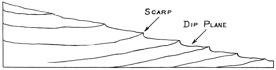
As these rock masses vary in hardness it follows that the surface is worn quite irregularly. A hard limestone will resist erosion more than a soft shale beneath it. Therefore, erosion processes will wear shale away up to the foot of the limestone and thus produce a greater or lesser escarpment, or scarp, along outcropping lines. Such scarps in most instances reach clear across the state and are a permanent feature in the landscape. For example, the Oread limestone forms a scarp which extends from Leavenworth southwest by way of Lawrence and Ottawa and Burlington and Sedan to the Oklahoma state line. Immediately underneath it throughout this distance we find a soft shale bed, the Lawrence shales, two hundred feet in thickness, which on account of their softness wear away as fast as the overlying Oread limestone will permit. This produces a face of a hill, or bluff, or scarp looking eastward which is easily traced as above named entirely across the state. Beneath these shales is another mass of limestone, with shales beneath it, and a scarp facing eastward along their line of outcropping, and so on till the entire state is covered. Figure 3 represents a vertical section across this kind of surface features produced by erosion of this kind of rock masses, alternating hard and soft rocks gently dipping away from the dip of the surface. The surface of such limestone masses dips gently to the west, and if the overlying shales are principally worn away we find a zone or strip of almost level country trending parallel with the outcropping lines, but which slopes gently to the west. The width of such a zone varies from place to place, sometimes being from ten to twenty miles wide. We call such an area a "dip plane," because it is a plane dipping with the rock strata in whatever direction that chances to be.
These dip planes are good catchment areas. The soil covering absorbs the rain and allows it to work downward through the vertical fissures in the limestone below so that it can follow the bedding planes westward, while our rivers flow eastward. Dip plane catchment areas are serviceable for storing water in the fissures and bedding planes of the underlying formations. Such ground waters gradually work their way westward throughout the eastern part of the state and may be had here and there farther to the west in the form of well waters.
Prev Page--Contents || Next Page--River Valleys
Kansas Geological Survey, Geology
Placed on web June 9, 2017; originally published 1913.
Comments to webadmin@kgs.ku.edu
The URL for this page is http://www.kgs.ku.edu/Publications/Bulletins/1/01_gene.html