Unit Using New 3-D Seismic Attributes
Identifying Subtle Fracture Trends in the Mississippian Saline
Aquifer Unit Using New 3-D Seismic Attributes |
KGS Open-file ##-## |
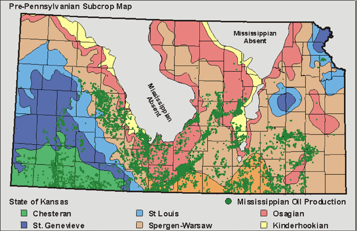
The Mississippian aquifer unit is present over most of Kansas, except where removed by subsequent erosion on the Central Kansas Uplift and Nemaha Uplift (Figure 4).

Figure 4. Mississippian Subcrop Map of Kansas
As can be seen by the green dots on Figure 4, the Mississippian aquifer unit in Kansas is associated with oil and gas reservoirs throughout the state. Approximately 1 billion barrels of oil have been produced from the Mississippian in Kansas, accounting for approximately 19% of total Kansas oil production and 33% of Kansas production for the past 10 years. Most of the Mississippian reservoirs are super-mature, but considerable amounts of petroleum remain to be produced using enhanced recovery techniques, such as CO2 flooding. Depleted petroleum reservoirs are expected to be good candidates for CO2 sequestration because of their proven seal integrity.
Wells drilled into the Mississippian for hydrocarbon exploration and production have provided a large amount of data on the thickness, porosity, temperature, pressure, and salinity of the Mississippian aquifer unit. All of these measurements are parameters that can be used in estimating CO2 sequestration potential. These data can be mapped regionally, as is exemplified by the total dissolved solids (TDS) map for the state of Kansas (Figure 5), constructed from 782 brine samples. Various parameters can be combined to estimate the regional CO2 sequestration potential. Preliminary calculations suggest that hundreds of millions of metric tons of CO2 could be stored in the Mississippian aquifer unit in Kansas.

Figure 5. Total Dissolved Solids in Mississippian Brines
Numerous 3-D seismic surveys have been acquired over petroleum-producing areas of the Mississippian aquifer. The seismic data provide local information which can help evaluate potential CO2 sequestration sites. An example of the value-added information provided by 3-D seismic data will be shown for a study area in Ness County, KS.
Previous Page |
|
Next Page |