Identifying Subtle Fracture Trends in the Mississippian Saline
Aquifer
Unit Using New 3-D Seismic Attributes
Unit Using New 3-D Seismic Attributes
Identifying Subtle Fracture Trends in the Mississippian Saline
Aquifer Unit Using New 3-D Seismic Attributes |
KGS Open-file ##-## |
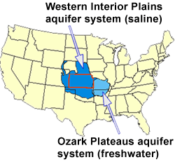
The Lower Paleozoic Ozark Plateau aquifer system is a widespread regional-scale aquifer system which extends over portions of 9 states (Figure 1). The freshwater component of the system, located primarily in Missouri and Arkansas, is known as the Ozark Plateaus (OP) aquifer system, while the saline component is referred to as the Western Interior Plains (WIP) aquifer system. The saline WIP aquifer system is a potential site for sequestration of large quantities of CO2.
 |
|
A generalized stratigraphic section for Kansas (Figure 2) shows that the Ozark Plateau aquifer system is divided into a lower unit of Cambrian sandstone and Cambro-Ordovician carbonates and an upper unit of Mississippian carbonates, separated by a confining unit of low permeability carbonates and shales.
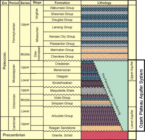
Figure 2. Generalized stratigraphy of Kansas, modified from Merriam (1963), Jorgensen et al. (1993), Cansler and Carr (2001).
The present study focuses on the upper (Mississippian) aquifer unit. In Kansas, this unit is composed primarily of naturally fractured, multi-layered shallow shelf carbonates of Chesterian, Meramecian, and Osagian age. The aquifer is unconformably overlain by Pennsylvanian shales of the Cherokee Group, which serve as a confining unit for the aquifer. The top of the Mississippian aquifer unit was subaerially exposed prior to the Pennsylvanian and has been modified by extensive karst, which resulted in solution-enhancement of the fractures. Fluid flow in the aquifer is strongly influenced by fracturing. The Mississippian aquifer unit is immediately underlain by low porosity and permeability Kinderhookian carbonates.
An example seismic section from Dickman Field, Ness County, KS (Figure 3), shows that the top and base of the Mississippian aquifer can be imaged seismically. The top of the aquifer is a positive seismic reflection (black), corresponding to the boundary between Cherokee shales and Mississippian dolomite seen on the gamma ray log. The base of the aquifer is also a positive seismic reflection, corresponding to the boundary between porous (18% porosity) Mississippian dolomite and tight (5% porosity) limestone of the Kinderhook Fm.

Figure 3. Seismic Section over Mississippian Aquifer
Previous Page |
|
Next Page |