Identifying Subtle Fracture Trends in the Mississippian Saline
Aquifer
Unit Using New 3-D Seismic Attributes
Unit Using New 3-D Seismic Attributes
Identifying Subtle Fracture Trends in the Mississippian Saline
Aquifer Unit Using New 3-D Seismic Attributes |
KGS Open-file ##-## |
Figure 6 show an enlargement of Figure 5 for Ness County, with the structure of the top of Mississippian superimposed. Blue lineaments have been interpreted from a dip map of the top of Mississippian structure (Figure 7). These blue lineaments show a regional structural fabric dominated by northeasterly and northwesterly trends. At several locations, the lineaments correspond to boundaries between regions of higher and lower salinity on the TDS map, suggesting that the structural lineaments can serve as boundaries to fluid flow in the aquifer.
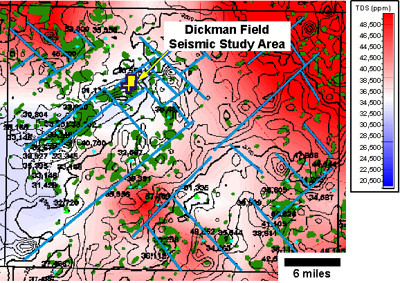
Figure 6. Total Dissolved Solids in Mississippian Brines, Ness County, Kansas. TDS data points are shown by blue diamonds and green triangles. Oil fields are shown in dark green.
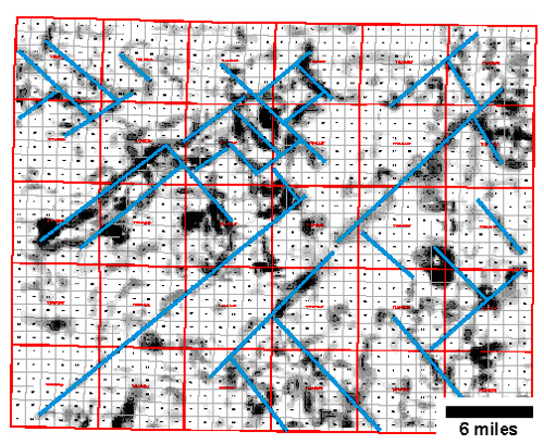
Figure 7. Dip map of the top of Mississippian surface for Ness County. Lineaments with high dip are likely to indicate faults. Interpreted lineaments are shown in blue.
The location of a 2 square mile 3-D seismic survey over Dickman Field, a Mississippian oil reservoir, is shown by the yellow polygon on Figure 6.
Previous Page |
|
Next Page |