Identifying Subtle Fracture Trends in the Mississippian Saline
Aquifer
Unit Using New 3-D Seismic Attributes
Unit Using New 3-D Seismic Attributes
Identifying Subtle Fracture Trends in the Mississippian Saline
Aquifer Unit Using New 3-D Seismic Attributes |
KGS Open-file ##-## |
Approximately 1.7 million barrels of oil have been produced from Dickman Field. Preliminary calculations predict that this reservoir has the potential to sequester approximately 190,000 metric tons of CO2 (based on the assumption that CO2 remains as a separate fluid phase and is stored by displacement of fluids) to 350,000 metric tons of CO2 (based on the assumption that CO2 dissolves in the brine). The calculators used to estimate CO2 sequestration are found at http://www.midcarb.org/calculators.shtml.
The seismic reflector corresponding to the top of the Mississippian aquifer has been interpreted across the Dickman 3-D seismic survey and has been used to construct a detailed map of the depth to the top of the Mississippian (Figure 8). This seismic depth map shows topographic detail that is not possible with well data alone and can be used to help refine estimates of the reservoir volume, and thus revise estimates of CO2 sequestration potential. The areas where the top of the Mississippian is beneath the oil-water contact are covered by the shaded overlay in Figure 8.
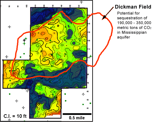
Figure 8. Seismic Depth Map of Top of Mississippian for Dickman Field
The northwest edge of Dickman Field corresponds to a down-to-the-north northeast-trending normal fault, which was seen as a lineament on the top of Mississippian dip map for Ness county (Figure 7). The Ness County map, constructed from well data alone, did not show any other structural lineaments in Dickman Field. The Dickman 3-D seismic data, however, has the potential to provide more structural detail. Effectively locating fractures is of particular interest, since fluid flow in the Mississippian aquifer is strongly influenced by fracturing.
The volumetric reflector curvature attribute shown in Figure 9 can reveal lineaments related to subtle faulting and fracturing (Sullivan et al., 2004). Maps of volumetric curvature extracted from the top and base of the Mississippian aquifer are superimposed to identify the vertical continuity of lineaments, as well as highlight any lineament offset with depth, which would indicate dip. Most of the lineaments appear to persist from the top to the base of the aquifer and are near vertical, although there does appears to be a consistent 65-70 degree northeasterly dip to the northwest-trending features in the northern portion of the survey.
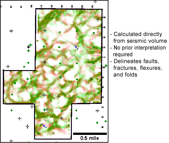
Figure 9. Volumetric reflector curvature attribute (maximum negative curvature) extracted along top of Mississippian Aquifer (green) and Base of Mississippian Aquifer (red).
Lineaments have been interpreted on a volumetric curvature map extracted along the seismic horizon corresponding to the base of the Mississippian aquifer (Figure 10). Rose diagrams of the interpreted lineaments show that there are two main directions of lineaments -- northeast and northwest, similar to regional lineament directions defined for Ness County.
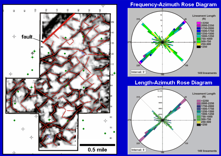
Figure 10. Left: Volumetric curvature extracted at the base of the Mississippian aquifer with interpreted lineaments in red. Right: Rose diagrams of the interpreted lineaments.
Although the number of lineaments interpreted with northeasterly and northwesterly trends is approximately equal (Figure 10, top right), northeast-trending lineaments have greater length and continuity than the northwest-trending lineaments (Figure 10, bottom right). The northeasterly lineament trend parallels the fault at the northwest corner of the seismic survey.
The next step in analyzing this data is to determine if any of the lineaments represent open fractures, which could serve as water conduits, or shale-filled fractures, which could be barriers to fluid flow.
Evidence for the presence of shale-filled fractures at the top of the Mississippian is found in a horizontal well from central Ness County, approximately 8 miles from the Dickman Field study area. In this well, numerous near-vertical shale intervals have been identified along the lateral length of the well (Figure 11). These intervals have been interpreted as solution-enhanced fractures extending down from the karst surface at the top of Mississippian that have been filled by Pennsylvanian Cherokee Shale (Carr et al., 2000).
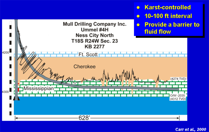
Figure 11. Shale-filled fractures intersected by a horizontal well in Ness County, Kansas
Since there are no horizontal wells in Dickman Field, indirect evidence must be used to infer the presence of shale-filled fractures. Since these fractures were solution-enhanced by karsting and are likely filled by both Pennsylvanian shale and weathered Mississippian debris, it is assumed that locations with evidence of a thicker section of weathered Mississippian material at the base of the Pennsylvanian (subsequently referred to as the “karsted zone”) are related to shale-filled fractures. For the purposes of this study, the karsted zone in each well was defined as the interval between the highest occurrence of the basal chert conglomerate in the Pennsylvanian section (chert weathered from the Mississippian) to the top of the Mississippian.
In order to determine whether the shale-filled fractures are preferentially related to either the northeast- or northwest-trending lineaments (i.e., was one particular fracture direction open and preferentially solution-enhanced during karsting?), crossplots were created of the thickness of the karsted zone versus the distance to the nearest northeast- and northwest-trending lineaments (Figure 12). These crossplots show that there is no apparent relationship between the thickness of the karsted zone and the northwest-trending lineaments; however, there is an increase in the thickness of the karsted zone within approximately 50 ft of the northeast-trending lineaments. The relationship between the thickness of the karsted zone and distance to the northeast-trending lineament suggests that interpreted northeast-trending lineaments are likely to represent fractures which were preferentially solution-enhanced during karsting and are filled with Pennsylvanian shale. Since some of the northeast trending lineaments have interpreted lengths in excess of 0.5 mile, they may provide significant barriers to fluid flow in the northwest-southeast direction.
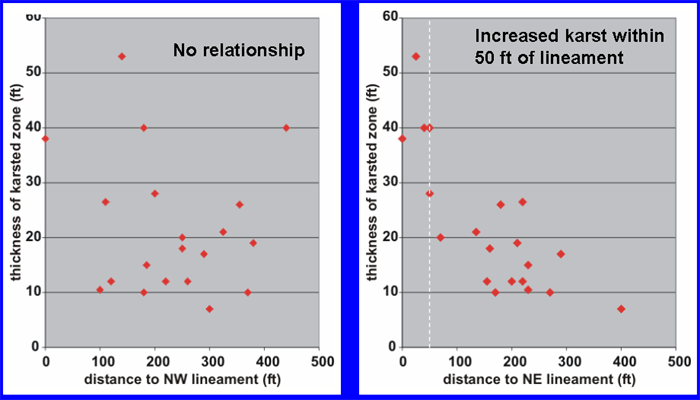
Figure 12. Thickness of karsted zone in well versus distance to nearest NW and NE lineaments
The relationship between the interpreted lineaments and fluid flow can be investigated by examining the spatial variability of fluid production from the wells in Dickman Field and by comparing fluid production to lineament proximity.
The map on the left of Figure 13 shows with light green circles the amount of oil produced from the Mississippian during the first 12 months of production for each well in Dickman Field. The largest circle corresponds to approximately 25,000 Bbl. The interpreted lineaments are shown in red and the areas where the top of Mississippian is below the oil-water contact are shown in dark blue. There is no obvious spatial link between wells with high oil production, as compared to wells with low oil production.
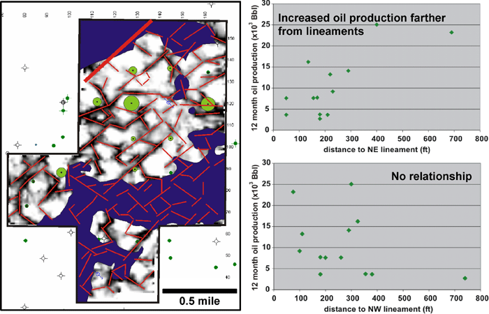
Figure 13. Left: Bubble map of oill production from the Mississippian. Right: Oil production versus distance to nearest NW and NE lineaments
In order to evaluate whether there is a link between oil production and either northeast- or northwest-trending lineaments, oil production is crossplotted against the distance to the nearest northeast- and northwest-trending lineaments (Figure 13, right). The crossplots indicate that there is no identifiable relationship between oil production and the northwest-trending lineaments but there does appear to be an overall increase in oil production away from the northeast-trending lineaments. This suggests that in proximity to the northeast-trending lineaments there may be a higher concentration of shale-filled fractures that inhibit oil production.
Water production from the wells in Dickman Field may be related to open fractures that extend into the underlying Mississippian aquifer. The blue circles on the lineament map at the left on Figure 14 show the amount of water produced from each well during the first 12 months of oil production. The largest circle corresponds to approximately 86,500 Bbl.
In order to evaluate whether open fractures are linked to either the northeast- or northwest-trending lineaments, water production is crossplotted against the distance to the nearest northeast- and northwest-trending lineaments. (Figure 14, right). The crossplots indicate that there is no relationship between water production and the northeast-trending lineaments but there is increased water production within 180 ft of the northwest-trending lineaments. This indicates that the northwest-trending lineaments represent fractures which serve as conduits to the aquifer.
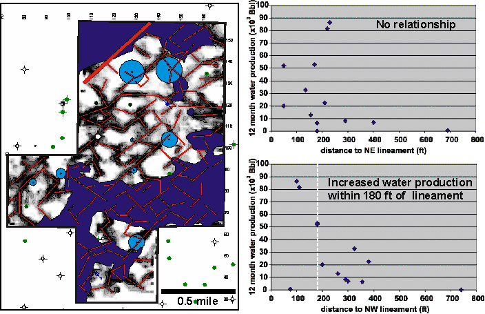
Figure 14. Left: Bubble map of water production from the Mississippian. Right: Water production versus distance to nearest NW and NE lineaments
Previous Page |
|
Next Page |