
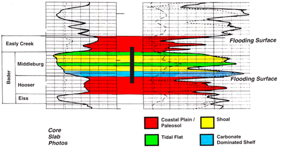
Lithofacies and Depositional Environments
In the Panoma field of southwest Kansas, the Council Grove Group comprises seven fourth-order marine-nonmarine sequences. Through the detailed study of ten widely distributed and lengthy cores, ten major lithofacies were identified and characterized.
During the period of Council Grove deposition, the Panoma field area was
situated on a broad shallow shelf that dipped gently to the south towards
the shelf edge of the Anadarko basin in Oklahoma. The geometry of the shelf
was conducive for broad, parallel depositional environments and associated
lithofacies belts. In response to cyclical sea-level fluctuations,
lithofacies belts migrated across the shelf resulting in a predictable vertical
succession of the ten major lithofacies. Thin, shallow water carbonates
with grain-supported textures (fine-medium and medium-coarse grained packstones
and grainstones typically are found at the base of each sequence during
the initial, shallow water portion of the flooding event.
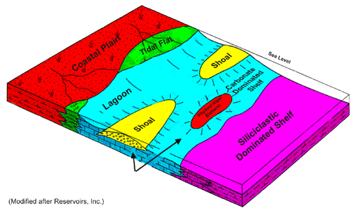
A typical upward vertical succession comprises deeper water
dark marine siltstones and silty carbonate mud- and wackestones. These are
overlain by “cleaner” mud- and wackestones deposited in shallower
water. With progressive shallowing these are overlain by either packstones
and grainstones, interpreted to indicate increased wave or tidal agitation;
quiet water, lagoonal, mudstones and wackestones; or silty dolomites and
dolomites where there was little or no wave agitation. With further regression
and exposure the carbonate flats
were blanketed with wind-blown silts, very fine sands and clay-rich silts
resulting in coastal
plain deposits of red nonmarine siltstones and shaly siltstones. All lithofacies,
except localized phylloid algal bafflestone, were identified in each of
the seven sequences, though not necessarily in each of the cores.
 |
 |
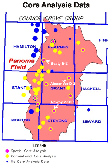
Core Analysis Data
Core analysis data utilized in this on-going study have been derived from measurements performed at the KGS as well as commercial laboratory data contributed by companies. Data represent analyses from over 30 wells and an attempt has been made to sample the complete range in porosity, permeability, geographic distribution, and formation for each of the major lithofacies.
Last updated June 2004
http://www.kgs.ku.edu/PRS/publication/2001-33/P1-06.html