


Wyandotte County--Oil and Gas Production
Production
| Year
| Oil
| Gas
|
Production
(bbls) |
Wells |
Cumulative
(bbls) |
Production
(mcf) |
Wells |
Cumulative
(mcf) |
Updated through 6-1992.
Note: bbls is barrels; mcf is 1000 cubic feet.
County Map
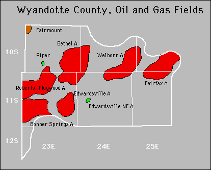

Fields
Also available is a text file containing field summary data for all fields in this county.
Abandoned
Bethel
Edwardsville
Fairfax
Welborn
Kansas Geological Survey
Comments to webadmin@kgs.ku.edu
URL=http://www.kgs.ku.edu/PRS/County/tw/wyandotte.html
Data from Kansas Dept. of Revenue files monthly.