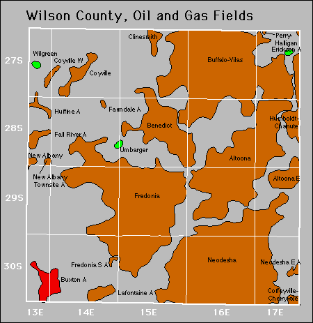
| Year | Oil | Gas | ||||
|---|---|---|---|---|---|---|
| Production (bbls) |
Wells | Cumulative (bbls) |
Production (mcf) |
Wells | Cumulative (mcf) |
|
| 1995 | 149,087 | 562 | 15,322,435 | 304,150 | 65 | 10,071,133 |
| 1996 | 175,482 | 1022 | 15,497,917 | 322,826 | 104 | 10,393,959 |
| 1997 | 173,475 | 976 | 15,671,392 | 470,963 | 104 | 10,864,922 |
| 1998 | 131,315 | 939 | 15,802,707 | 701,654 | 115 | 11,566,576 |
| 1999 | 106,649 | 866 | 15,909,356 | 679,231 | 124 | 12,245,807 |
| 2000 | 112,497 | 955 | 16,021,853 | 635,502 | 124 | 12,881,309 |
| 2001 | 113,678 | 977 | 16,135,531 | 913,563 | 152 | 13,794,872 |
| 2002 | 100,700 | 947 | 16,236,231 | 1,411,679 | 211 | 15,206,551 |
| 2003 | 103,642 | 944 | 16,339,873 | 2,455,366 | 257 | 17,661,917 |
| 2004 | 97,876 | 940 | 16,437,749 | 3,857,000 | 379 | 21,518,917 |
| 2005 | 104,133 | 1023 | 16,541,882 | 5,327,100 | 658 | 26,846,017 |
| 2006 | 102,241 | 1048 | 16,644,123 | 8,786,249 | 1585 | 35,632,266 |
| 2007 | 84,580 | 1017 | 16,728,703 | 15,411,982 | 2249 | 51,044,248 |
| 2008 | 102,919 | 1079 | 16,831,622 | 17,134,397 | 2351 | 68,178,645 |
| 2009 | 107,862 | 1119 | 16,939,484 | 15,362,449 | 2429 | 83,541,094 |
| 2010 | 120,440 | 1146 | 17,059,924 | 12,520,366 | 2278 | 96,061,460 |
| 2011 | 148,631 | 1195 | 17,208,555 | 11,497,175 | 2240 | 107,558,635 |
| 2012 | 138,676 | 1251 | 17,347,231 | 10,237,183 | 2138 | 117,795,818 |
| 2013 | 169,435 | 1276 | 17,516,666 | 8,980,286 | 2071 | 126,776,104 |
| 2014 | 153,609 | 1338 | 17,670,275 | 8,092,734 | 2073 | 134,868,838 |
| 2015 | 127,261 | 1209 | 17,797,536 | 7,616,001 | 2050 | 142,484,839 |
| 2016 | 103,801 | 1232 | 17,901,337 | 6,764,431 | 1950 | 149,249,270 |
| 2017 | 98,118 | 1166 | 17,999,455 | 6,075,011 | 1892 | 155,324,281 |
| 2018 | 97,261 | 1215 | 18,096,716 | 5,328,084 | 1620 | 160,652,365 |
| 2019 | 96,266 | 1129 | 18,192,982 | 4,600,647 | 1420 | 165,253,012 |
| 2020 | 77,122 | 1091 | 18,270,104 | 4,052,783 | 1306 | 169,305,795 |
| 2021 | 72,261 | 850 | 18,342,365 | 3,485,509 | 1378 | 172,791,304 |
| 2022 | 88,535 | 1027 | 18,430,900 | 3,321,332 | 1256 | 176,112,636 |
| 2023 | 81,249 | 1022 | 18,512,149 | 3,125,981 | 1218 | 179,238,617 |
| 2024 | 76,396 | 1016 | 18,588,545 | 2,654,281 | 1158 | 181,892,898 |
| 2025 | 63,305 | 932 | 18,651,850 | 1,650,896 | 964 | 183,543,794 |


Abandoned
Gas Storage Fields