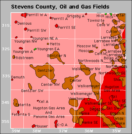
| Year | Oil | Gas | ||||
|---|---|---|---|---|---|---|
| Production (bbls) |
Wells | Cumulative (bbls) |
Production (mcf) |
Wells | Cumulative (mcf) |
|
| 1995 | 671,349 | 178 | 16,774,651 | 171,370,778 | 1993 | 7,328,538,321 |
| 1996 | 553,022 | 188 | 17,327,673 | 173,349,354 | 2096 | 7,501,887,675 |
| 1997 | 439,556 | 167 | 17,767,229 | 157,462,935 | 2135 | 7,659,350,610 |
| 1998 | 403,812 | 129 | 18,171,041 | 138,317,488 | 2138 | 7,797,668,098 |
| 1999 | 538,790 | 128 | 18,709,831 | 126,079,864 | 2118 | 7,923,747,962 |
| 2000 | 659,681 | 150 | 19,369,512 | 122,069,522 | 2126 | 8,045,817,484 |
| 2001 | 826,918 | 157 | 20,196,430 | 101,402,851 | 2141 | 8,147,220,335 |
| 2002 | 640,510 | 133 | 20,836,940 | 91,982,429 | 2141 | 8,239,202,764 |
| 2003 | 744,148 | 151 | 21,581,088 | 80,372,617 | 2133 | 8,319,575,381 |
| 2004 | 548,160 | 140 | 22,129,248 | 72,021,615 | 2132 | 8,391,596,996 |
| 2005 | 431,361 | 139 | 22,560,609 | 64,534,259 | 2137 | 8,456,131,255 |
| 2006 | 399,899 | 118 | 22,960,508 | 61,828,382 | 2171 | 8,517,959,637 |
| 2007 | 1,063,310 | 142 | 24,023,818 | 62,905,269 | 2177 | 8,580,864,906 |
| 2008 | 1,298,297 | 163 | 25,322,115 | 62,114,633 | 2192 | 8,642,979,539 |
| 2009 | 954,585 | 150 | 26,276,700 | 53,903,404 | 2192 | 8,696,882,943 |
| 2010 | 678,782 | 140 | 26,955,482 | 48,739,074 | 2191 | 8,745,622,017 |
| 2011 | 659,705 | 150 | 27,615,187 | 44,344,103 | 2190 | 8,789,966,120 |
| 2012 | 511,980 | 144 | 28,127,167 | 40,379,327 | 2189 | 8,830,345,447 |
| 2013 | 517,755 | 149 | 28,644,922 | 36,986,379 | 2181 | 8,867,331,826 |
| 2014 | 403,973 | 153 | 29,048,895 | 33,861,853 | 2199 | 8,901,193,679 |
| 2015 | 325,565 | 154 | 29,374,460 | 33,971,692 | 2159 | 8,935,165,371 |
| 2016 | 279,314 | 135 | 29,653,774 | 30,726,564 | 2159 | 8,965,891,935 |
| 2017 | 265,228 | 137 | 29,919,002 | 28,784,920 | 2117 | 8,994,676,855 |
| 2018 | 269,081 | 130 | 30,188,083 | 27,267,914 | 2111 | 9,021,944,769 |
| 2019 | 267,793 | 124 | 30,455,876 | 25,861,296 | 2106 | 9,047,806,065 |
| 2020 | 229,860 | 108 | 30,685,736 | 24,305,997 | 2084 | 9,072,112,062 |
| 2021 | 220,848 | 100 | 30,906,584 | 22,807,015 | 2059 | 9,094,919,077 |
| 2022 | 223,497 | 119 | 31,130,081 | 21,612,150 | 2058 | 9,116,531,227 |
| 2023 | 210,178 | 112 | 31,340,259 | 20,378,592 | 2041 | 9,136,909,819 |
| 2024 | 245,120 | 100 | 31,585,379 | 18,929,480 | 2010 | 9,155,839,299 |
| 2025 | 161,933 | 101 | 31,747,312 | 13,520,715 | 1988 | 9,169,360,014 |


Abandoned