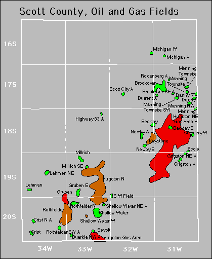
| Year | Oil | Gas | ||||
|---|---|---|---|---|---|---|
| Production (bbls) |
Wells | Cumulative (bbls) |
Production (mcf) |
Wells | Cumulative (mcf) |
|
| 1995 | 369,483 | 89 | 7,294,741 | 310,411 | 20 | 7,138,126 |
| 1996 | 284,959 | 85 | 7,579,700 | 287,635 | 19 | 7,425,761 |
| 1997 | 255,905 | 88 | 7,835,605 | 300,678 | 23 | 7,726,439 |
| 1998 | 253,968 | 89 | 8,089,573 | 339,931 | 22 | 8,066,370 |
| 1999 | 271,882 | 84 | 8,361,455 | 337,446 | 21 | 8,403,816 |
| 2000 | 361,349 | 92 | 8,722,804 | 317,998 | 22 | 8,721,814 |
| 2001 | 278,553 | 87 | 9,001,357 | 307,499 | 20 | 9,029,313 |
| 2002 | 269,023 | 91 | 9,270,380 | 259,002 | 21 | 9,288,315 |
| 2003 | 264,985 | 94 | 9,535,365 | 275,241 | 21 | 9,563,556 |
| 2004 | 272,077 | 98 | 9,807,442 | 271,927 | 19 | 9,835,483 |
| 2005 | 261,843 | 102 | 10,069,285 | 244,796 | 19 | 10,080,279 |
| 2006 | 410,714 | 111 | 10,479,999 | 246,198 | 20 | 10,326,477 |
| 2007 | 405,683 | 130 | 10,885,682 | 213,533 | 21 | 10,540,010 |
| 2008 | 551,018 | 138 | 11,436,700 | 337,605 | 21 | 10,877,615 |
| 2009 | 558,202 | 145 | 11,994,902 | 346,788 | 19 | 11,224,403 |
| 2010 | 662,699 | 167 | 12,657,601 | 375,415 | 23 | 11,599,818 |
| 2011 | 705,731 | 189 | 13,363,332 | 432,586 | 23 | 12,032,404 |
| 2012 | 649,963 | 214 | 14,013,295 | 356,144 | 23 | 12,388,548 |
| 2013 | 826,623 | 247 | 14,839,918 | 337,120 | 22 | 12,725,668 |
| 2014 | 1,321,337 | 304 | 16,161,255 | 254,462 | 22 | 12,980,130 |
| 2015 | 1,011,235 | 315 | 17,172,490 | 249,303 | 19 | 13,229,433 |
| 2016 | 786,594 | 319 | 17,959,084 | 219,632 | 18 | 13,449,065 |
| 2017 | 708,967 | 324 | 18,668,051 | 200,307 | 16 | 13,649,372 |
| 2018 | 589,447 | 321 | 19,257,498 | 190,709 | 12 | 13,840,081 |
| 2019 | 547,461 | 329 | 19,804,959 | 166,402 | 10 | 14,006,483 |
| 2020 | 435,916 | 298 | 20,240,875 | 67,945 | 10 | 14,074,428 |
| 2021 | 462,354 | 288 | 20,703,229 | 82,683 | 10 | 14,157,111 |
| 2022 | 514,784 | 352 | 21,218,013 | 179,382 | 9 | 14,336,493 |
| 2023 | 519,504 | 302 | 21,737,517 | 145,200 | 11 | 14,481,693 |
| 2024 | 451,015 | 296 | 22,188,532 | 102,511 | 11 | 14,584,204 |
| 2025 | 301,286 | 290 | 22,489,818 | 46,510 | 7 | 14,630,714 |


Abandoned
Durrant
Grigston
Rodenberg
Shallow Water Northeast