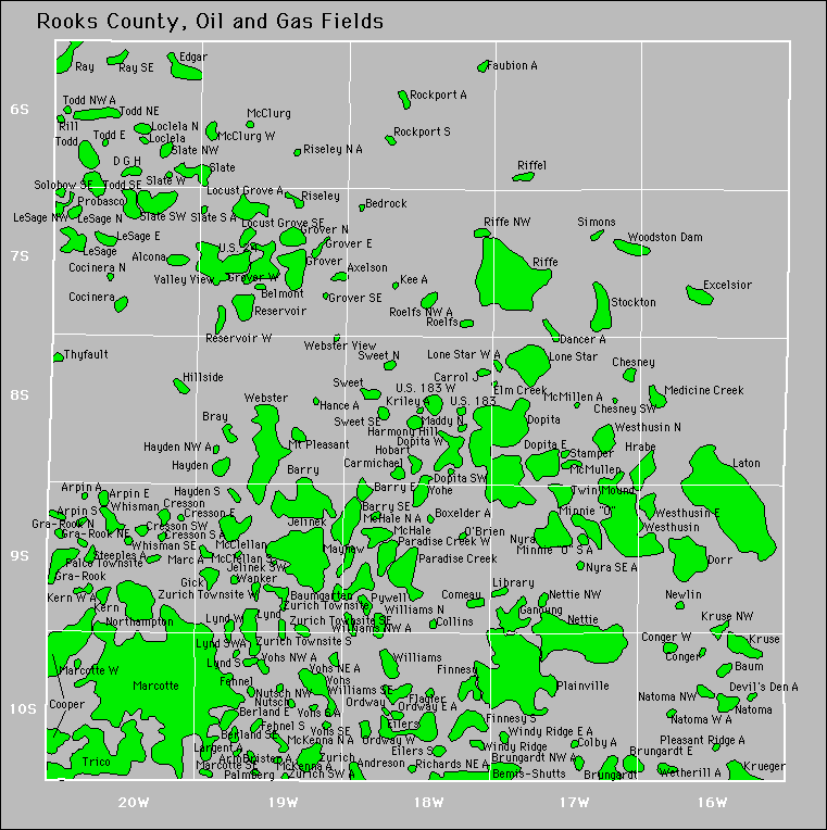
Air Park
Alcona
Alcona North
Alcona South
Alcona West
Andreson
Armbrister
Armbrister East
Arpin East
Arpin Northeast
Arpin South
Arpin Southwest
Axelson
Axelson Northeast
Barry
Barry East
Barry Southeast
Baum
Baumgarten
Bedrock
Bedrock Southeast
Bemis-Shutts
Bentz
Berland East
Boxelder
Boxelder Northwest
Bray
Brungardt
Brungardt East
Carmichael
Carrol J
Cedar Links
Chesney
Chesney Southwest
Cocinera
Cocinera East
Cocinera North
Cocinera Northeast
Cocinera Northwest
Cocinera Southwest
Cocinera West
Codell
Codell East
Colby
Colby West
Collins
Comeau
Conger
Conger West
Cooper
Cresson
Cresson East
|
Cresson South
Cresson Southwest
Crl
D G H
Damar
Damar Townsite
Devils Den
Dopita
Dopita East
Dopita Southwest
Dopita West
Dorr
Edgar
Edgar East
Edgar North
Edgar Southwest
Edgar West
Eilers
Eilers South
Elm Creek
Et
Eugene
Excelsior
Farmington Township
Faubion
Faubion South
Fehnel
Fehnel South
Finnesy
Finnesy South
Flagler
Ganoung
Gick
Gosser
Gra-Rook
Gra-Rook North
Gra-Rook Northeast
Grover
Grover East
Grover North
Grover South
Grover Southeast
Grover West
Harmony Hill
Harmony Hill Northwest
Hayden
Hayden South
Hillside
Hobart
Hobart Northwest
Hrabe
Jelinek
|
Jelinek Southwest
Kee
Keiswetter
Kern
Kern West
Kollman
Krueger
Kruse
Kruse Northwest
Largent South
Laton
Lesage
Lesage East
Lesage North
Lesage Northeast
Lesage Northwest
Lesage South
Library
Loclela
Loclela North
Locust Grove
Locust Grove North
Locust Grove Southeast
Logan Township
Lone Star
Lynd
Lynd South
Lynd Southwest
Lynd West
Maddy
Maddy North
Marcotte
Marcotte Southeast
Marcotte West
Mayhew
Mcclellan
Mcclellan South
Mcclurg
Mcclurg West
Mchale
Mchale North
Mckenna
Mckenna North
Mcmillen
Mcmullen
Medicine Creek
Medicine Creek East
Minnie 'O'
Mt. Pleasant
Natoma
Natoma Northwest
Natoma West
|
Nettie
Nettie Northwest
Newlin
Nicodemus East
Nicodemus Southeast
Northampton
Nutsch
Nutsch Northwest
Nutsch South
Nyra
Nyra Southeast
O'Brien
Ordway East
Ordway West
P-Ville
Palco Townsite
Palmberg
Paradise Creek
Paradise Creek East
Paradise Creek West
Pebbles
Plainville
Probasco
Pywell
Ray
Ray Southeast
Reservoir
Reservoir Northwest
Reservoir West
Richards Northeast
Riffe
Riffe Northwest
Riffel
Rill
Riseley
Riseley North
Rocken 3
Rockport South
Rocky Hill
Roelfs
Roelfs Northwest
Simons
Simons West
Simosh
Slate
Slate East
Slate Northwest
Slate South
Slate Southwest
Slate West
Solobow Southeast
Sst
|
Stamper
Steeples
Stockton
Sweet
Sweet North
Sweet Southeast
Thyfault
Thyfault East
Todd
Todd East
Todd Northeast
Todd Northwest
Todd Southeast
Trico
Twin Mound
U. S. 183
U. S. 183 West
U. S. 24
Valley View
Valley View North
Vohs
Vohs East
Vohs North
Vohs Northeast
Wanker
Webster
Webster View
Webster View Southeast
Westhusin
Westhusin East
Westhusin North
Wetherill
Whisman
Whisman Southeast
Williams
Williams North
Williams Northwest
Williams Southeast
Windy Ridge
Windy Ridge East
Woodston Dam
Yohe
Zurich
Zurich Townsite
Zurich Townsite South
Zurich Townsite Southeast
Zurich Townsite West
|

