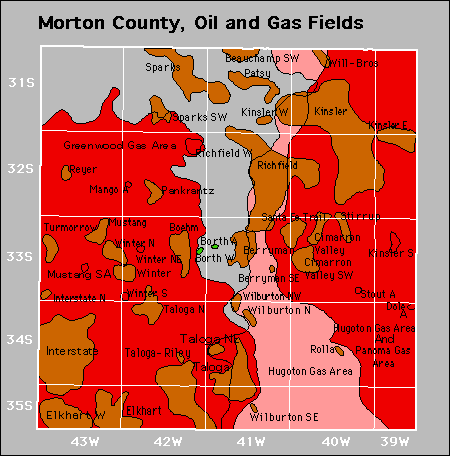
| Year | Oil | Gas | ||||
|---|---|---|---|---|---|---|
| Production (bbls) |
Wells | Cumulative (bbls) |
Production (mcf) |
Wells | Cumulative (mcf) |
|
| 1995 | 1,135,262 | 328 | 70,436,395 | 65,411,979 | 1266 | 3,055,146,265 |
| 1996 | 860,530 | 224 | 71,296,925 | 64,241,331 | 1350 | 3,119,387,596 |
| 1997 | 720,802 | 208 | 72,017,727 | 59,987,957 | 1383 | 3,179,375,553 |
| 1998 | 682,556 | 202 | 72,700,283 | 52,779,035 | 1384 | 3,232,154,588 |
| 1999 | 573,872 | 202 | 73,274,155 | 47,395,991 | 1308 | 3,279,550,579 |
| 2000 | 512,544 | 201 | 73,786,699 | 43,398,711 | 1298 | 3,322,949,290 |
| 2001 | 508,216 | 198 | 74,294,915 | 41,311,225 | 1308 | 3,364,260,515 |
| 2002 | 492,794 | 207 | 74,787,709 | 43,346,936 | 1312 | 3,407,607,451 |
| 2003 | 454,030 | 212 | 75,241,739 | 33,826,986 | 1323 | 3,441,434,437 |
| 2004 | 470,776 | 294 | 75,712,515 | 30,243,021 | 1304 | 3,471,677,458 |
| 2005 | 694,401 | 295 | 76,406,916 | 27,713,022 | 1296 | 3,499,390,480 |
| 2006 | 933,461 | 273 | 77,340,377 | 25,477,000 | 1291 | 3,524,867,480 |
| 2007 | 722,161 | 175 | 78,062,538 | 23,146,253 | 1278 | 3,548,013,733 |
| 2008 | 760,636 | 182 | 78,823,174 | 23,835,399 | 1274 | 3,571,849,132 |
| 2009 | 694,370 | 181 | 79,517,544 | 25,397,839 | 1265 | 3,597,246,971 |
| 2010 | 567,385 | 186 | 80,084,929 | 23,790,080 | 1255 | 3,621,037,051 |
| 2011 | 513,381 | 178 | 80,598,310 | 19,928,619 | 1227 | 3,640,965,670 |
| 2012 | 548,867 | 160 | 81,147,177 | 17,862,438 | 1217 | 3,658,828,108 |
| 2013 | 475,792 | 148 | 81,622,969 | 16,028,076 | 1184 | 3,674,856,184 |
| 2014 | 445,537 | 152 | 82,068,506 | 14,931,593 | 1180 | 3,689,787,777 |
| 2015 | 404,397 | 153 | 82,472,903 | 13,841,808 | 1174 | 3,703,629,585 |
| 2016 | 373,321 | 140 | 82,846,224 | 12,795,632 | 1157 | 3,716,425,217 |
| 2017 | 317,010 | 149 | 83,163,234 | 12,495,824 | 1134 | 3,728,921,041 |
| 2018 | 290,522 | 126 | 83,453,756 | 11,873,666 | 1130 | 3,740,794,707 |
| 2019 | 277,688 | 129 | 83,731,444 | 10,740,244 | 1118 | 3,751,534,951 |
| 2020 | 264,327 | 119 | 83,995,771 | 10,014,525 | 1089 | 3,761,549,476 |
| 2021 | 248,629 | 117 | 84,244,400 | 9,290,355 | 1064 | 3,770,839,831 |
| 2022 | 230,658 | 112 | 84,475,058 | 8,667,418 | 1050 | 3,779,507,249 |
| 2023 | 206,680 | 119 | 84,681,738 | 8,097,236 | 1048 | 3,787,604,485 |
| 2024 | 209,831 | 107 | 84,891,569 | 7,581,522 | 1009 | 3,795,186,007 |
| 2025 | 154,933 | 109 | 85,046,502 | 5,785,670 | 993 | 3,800,971,677 |


Abandoned
Gas Storage Fields