| Year | Oil | Gas | ||||
|---|---|---|---|---|---|---|
| Production (bbls) |
Wells | Cumulative (bbls) |
Production (mcf) |
Wells | Cumulative (mcf) |
|
| 1995 | 26,956 | 45 | 2,591,780 | 144,562 | 44 | 2,519,862 |
| 1996 | 20,156 | 119 | 2,611,936 | 149,795 | 58 | 2,669,657 |
| 1997 | 16,012 | 117 | 2,627,948 | 185,531 | 63 | 2,855,188 |
| 1998 | 16,760 | 103 | 2,644,708 | 154,473 | 68 | 3,009,661 |
| 1999 | 13,791 | 112 | 2,658,499 | 80,316 | 68 | 3,089,977 |
| 2000 | 10,867 | 87 | 2,669,366 | 101,765 | 50 | 3,191,742 |
| 2001 | 14,234 | 84 | 2,683,600 | 138,254 | 86 | 3,329,996 |
| 2002 | 11,317 | 109 | 2,694,917 | 204,365 | 100 | 3,534,361 |
| 2003 | 10,801 | 91 | 2,705,718 | 336,792 | 123 | 3,871,153 |
| 2004 | 12,616 | 108 | 2,718,334 | 692,446 | 135 | 4,563,599 |
| 2005 | 11,870 | 162 | 2,730,204 | 1,401,094 | 197 | 5,964,693 |
| 2006 | 10,341 | 141 | 2,740,545 | 2,017,587 | 291 | 7,982,280 |
| 2007 | 18,999 | 123 | 2,759,544 | 2,794,027 | 437 | 10,776,307 |
| 2008 | 16,328 | 116 | 2,775,872 | 3,851,529 | 516 | 14,627,836 |
| 2009 | 10,131 | 134 | 2,786,003 | 3,938,460 | 593 | 18,566,296 |
| 2010 | 8,253 | 108 | 2,794,256 | 4,239,060 | 671 | 22,805,356 |
| 2011 | 6,808 | 88 | 2,801,064 | 4,568,417 | 689 | 27,373,773 |
| 2012 | 7,271 | 125 | 2,808,335 | 4,038,998 | 675 | 31,412,771 |
| 2013 | 6,316 | 140 | 2,814,651 | 3,533,561 | 648 | 34,946,332 |
| 2014 | 7,214 | 105 | 2,821,865 | 3,290,661 | 642 | 38,236,993 |
| 2015 | 6,083 | 81 | 2,827,948 | 3,061,922 | 629 | 41,298,915 |
| 2016 | 5,746 | 92 | 2,833,694 | 2,835,052 | 600 | 44,133,967 |
| 2017 | 6,645 | 103 | 2,840,339 | 2,646,774 | 571 | 46,780,741 |
| 2018 | 6,086 | 95 | 2,846,425 | 2,355,845 | 554 | 49,136,586 |
| 2019 | 7,313 | 106 | 2,853,738 | 2,150,808 | 517 | 51,287,394 |
| 2020 | 4,338 | 81 | 2,858,076 | 1,812,798 | 502 | 53,100,192 |
| 2021 | 3,133 | 92 | 2,861,209 | 1,687,058 | 489 | 54,787,250 |
| 2022 | 4,261 | 76 | 2,865,470 | 1,722,138 | 500 | 56,509,388 |
| 2023 | 6,523 | 101 | 2,871,993 | 1,689,058 | 510 | 58,198,446 |
| 2024 | 4,582 | 105 | 2,876,575 | 1,427,956 | 497 | 59,626,402 |
| 2025 | 2,561 | 70 | 2,879,136 | 1,023,862 | 456 | 60,650,264 |


Abandoned
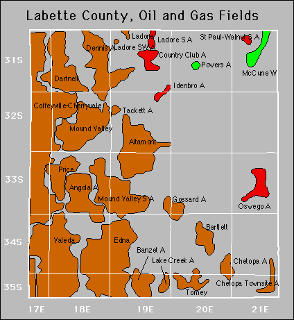
Chetopa
Chetopa Townsite
Gossard
Idenbro
Powers
Price