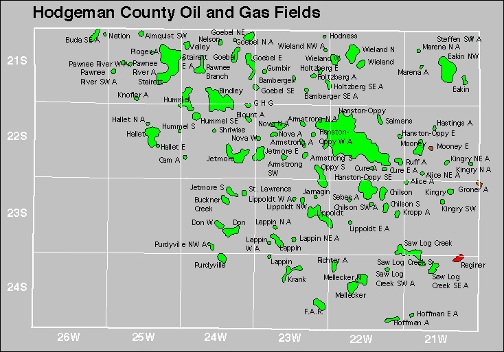
| Year | Oil | Gas | ||||
|---|---|---|---|---|---|---|
| Production (bbls) |
Wells | Cumulative (bbls) |
Production (mcf) |
Wells | Cumulative (mcf) |
|
| 1995 | 494,972 | 283 | 38,673,982 | 16,215 | 2 | 955,553 |
| 1996 | 473,245 | 233 | 39,147,227 | - | - | 955,553 |
| 1997 | 462,131 | 241 | 39,609,358 | - | - | 955,553 |
| 1998 | 460,420 | 212 | 40,069,778 | - | - | 955,553 |
| 1999 | 370,751 | 203 | 40,440,529 | - | - | 955,553 |
| 2000 | 398,987 | 210 | 40,839,516 | 37,098 | 1 | 992,651 |
| 2001 | 380,564 | 208 | 41,220,080 | 8,075 | 1 | 1,000,726 |
| 2002 | 364,664 | 216 | 41,584,744 | - | - | 1,000,726 |
| 2003 | 354,200 | 210 | 41,938,944 | - | - | 1,000,726 |
| 2004 | 345,186 | 212 | 42,284,130 | - | - | 1,000,726 |
| 2005 | 336,284 | 211 | 42,620,414 | 91,770 | 8 | 1,092,496 |
| 2006 | 323,927 | 216 | 42,944,341 | 731,043 | 17 | 1,823,539 |
| 2007 | 303,644 | 216 | 43,247,985 | 588,905 | 19 | 2,412,444 |
| 2008 | 341,951 | 215 | 43,589,936 | 551,195 | 23 | 2,963,639 |
| 2009 | 437,291 | 221 | 44,027,227 | 114,859 | 22 | 3,078,498 |
| 2010 | 428,675 | 235 | 44,455,902 | - | - | 3,078,498 |
| 2011 | 476,736 | 257 | 44,932,638 | - | - | 3,078,498 |
| 2012 | 601,514 | 285 | 45,534,152 | - | - | 3,078,498 |
| 2013 | 760,686 | 297 | 46,294,838 | 46,676 | 12 | 3,125,174 |
| 2014 | 651,227 | 303 | 46,946,065 | 264,938 | 16 | 3,390,112 |
| 2015 | 527,331 | 277 | 47,473,396 | 363,703 | 20 | 3,753,815 |
| 2016 | 432,372 | 273 | 47,905,768 | 291,310 | 16 | 4,045,125 |
| 2017 | 410,835 | 271 | 48,316,603 | 255,420 | 19 | 4,300,545 |
| 2018 | 409,390 | 264 | 48,725,993 | 505,415 | 18 | 4,805,960 |
| 2019 | 428,369 | 275 | 49,154,362 | 574,678 | 18 | 5,380,638 |
| 2020 | 425,697 | 264 | 49,580,059 | 596,951 | 19 | 5,977,589 |
| 2021 | 410,880 | 253 | 49,990,939 | 513,351 | 19 | 6,490,940 |
| 2022 | 404,623 | 260 | 50,395,562 | 490,763 | 19 | 6,981,703 |
| 2023 | 418,615 | 270 | 50,814,177 | 478,602 | 19 | 7,460,305 |
| 2024 | 432,292 | 279 | 51,246,469 | 498,202 | 20 | 7,958,507 |
| 2025 | 275,875 | 265 | 51,522,344 | 343,174 | 19 | 8,301,681 |


| Abandoned | ||
|---|---|---|
| Alice Armstrong Cam Hastings Hoffman Holtzberg |
Holtzberg Southeast Kingry Northeast Marena Nova North Pawnee River Ploger |
Ruff Salmans Wieland |