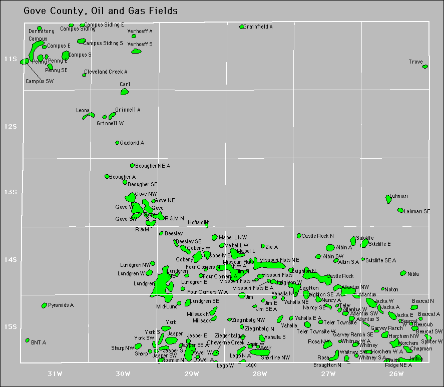
Aesir
Aesir West
Albin
Albin South
Albin Southwest
Albin West
Antelope Ridge
Antelope Ridge East
Antelope Ridge Northeast
Antelope Ridge Northwest
Atlantus
Atlantus Northwest
Atlantus South
Atlantus Southwest
Atlantus West
Bearcat
Bearcat North
Bearcat Southwest
Bearcat West
Bearcub
Bearcub North
Beesley
Beesley Northeast
Beesley Southeast
Beougher Northeast
Beougher Southeast
Bnt
Bridges Northeast
Briggs
Brownie
Brownie Southeast
Butterfield-Overland
Butterfield-Overland North
Butterfield-Overland Northeast
Butterfield-Overland South
Butterfield-Overland Southeast
Cale
Cale North
Campus
Campus East
Campus Siding
Campus Siding East
Campus Siding South
Campus South
Campus Southwest
Carl
Castle Bluff
|
Castle Rock
Castle Rock North
Chapman
Cheyenne Creek
Cheyenne Creek Northeast
Cleveland Creek
Cleveland Creek South
Cleveland Creek Southwest
Cleveland Creek West
Coberly
Coberly East
Coberly West
Doll Northwest
Dormitory
Dowell
Dowell North
Dowell West
Eagle Ridge
Flora Creek Land
Four Corners
Four Corners North
Four Corners Southeast
Four Corners West
Gaeland
Gaeland Township
Gaeland Township East
Gaeland West
Garvey Ranch
Garvey Ranch East
Garvey Ranch North
Garvey Ranch Southeast
Goherl
Gove
Gove Northeast
Gove Northwest
Gove South
Gove Southwest
Gove Townsite
Gove Townsite South
Gove West
Grainfield
Grainfield West
Grinnell West
Heier
Hoffsmith
Hoffsmith East
Horchem
|
Horchem Northwest
Horchem West
Jacka
Jacka East
Jacka West
Jasper
Jasper East
Jasper South
Jasper Southeast
Jasper Southwest
Jim
Jim East
Jim North
Jim South
Jim Southeast
Judica
Juggernaut
Kearns
Krw
Lago
Lago North
Lahman
Lahman Northwest
Lahman Southeast
Leighton
Leighton North
Leighton South
Leighton Southeast
Leighton Southwest
Leighton West
Leona
Leona South
Lo-Ri
Lo-Ri Northeast
Lodestar
Logo
Logo East
Logo North
Logo Southeast
Lundgren
Lundgren East
Lundgren Northeast
Lundgren Northwest
Lundgren Southeast
Lundgren Southwest
Lundgren West
Mabel L
|
Mabel L Northwest
Mabel L West
Maurice East
Maurice Northeast
Mid-Lund
Millsack
Millsack North
Missouri Flats
Missouri Flats East
Missouri Flats Northeast
Missouri Flats Northwest
Missouri Flats South
Missouri Flats West
Morning Glory
Nancy
Nancy Southeast
Nibla
Nibla East
Nibla South
Nibla Southeast
Nibla West
Noton
Noton Southeast
Overland
Overland Northwest
Overland Peak
Penny
Penny East
Penny South
Penny Southeast
Priefert
Pyramids North
Q-B
Q-B West
R & M
R & M North
Roemer North
Rosa
Rosa Northwest
Rrl
Rudzik
Rudzik South
Shanline
Shanline Northeast
Shanline Northwest
Sharp
Sharp Northwest
|
Smoky Hill River
Splitter
Splitter West
Spotted Pony
Steep Cliff
Sutcliffe
Sutcliffe East
Sutcliffe North
Sutcliffe Southeast
Swift Fox
Swift Fox North
Swift Fox Southeast
Teler
Teler Townsite
Teler Townsite West
Thies Ranch
Thies Ranch East
Thies Ranch North
Tnt
Trove
Tustin
Tustin Northwest
Twilight
Valhalla
Valhalla East
Valhalla Northeast
Valhalla South
Verhoeff
Verhoeff South
Whitney
Whitney South
Whitney Southwest
Whitney West
X36
York
York Northwest
York South
York Southwest
Zeigenbalg West
Zie
Ziegenbalg
Ziegenbalg North
Ziegenbalg Northeast
Ziegenbalg Northwest
Ziegenbalg Southwest
|

