| Year | Oil | Gas | ||||
|---|---|---|---|---|---|---|
| Production (bbls) |
Wells | Cumulative (bbls) |
Production (mcf) |
Wells | Cumulative (mcf) |
|
| 1995 | 106,191 | 65 | 2,120,553 | 924,122 | 28 | 35,862,808 |
| 1996 | 96,232 | 40 | 2,216,785 | 905,630 | 26 | 36,768,438 |
| 1997 | 86,880 | 44 | 2,303,665 | 740,946 | 24 | 37,509,384 |
| 1998 | 76,751 | 38 | 2,380,416 | 700,418 | 26 | 38,209,802 |
| 1999 | 74,338 | 43 | 2,454,754 | 648,381 | 27 | 38,858,183 |
| 2000 | 75,802 | 41 | 2,530,556 | 526,040 | 25 | 39,384,223 |
| 2001 | 70,398 | 37 | 2,600,954 | 413,285 | 24 | 39,797,508 |
| 2002 | 65,829 | 38 | 2,666,783 | 481,562 | 25 | 40,279,070 |
| 2003 | 63,024 | 33 | 2,729,807 | 608,626 | 24 | 40,887,696 |
| 2004 | 60,568 | 39 | 2,790,375 | 333,652 | 24 | 41,221,348 |
| 2005 | 55,430 | 29 | 2,845,805 | 286,691 | 23 | 41,508,039 |
| 2006 | 73,235 | 33 | 2,919,040 | 225,273 | 24 | 41,733,312 |
| 2007 | 121,857 | 37 | 3,040,897 | 215,823 | 24 | 41,949,135 |
| 2008 | 185,263 | 50 | 3,226,160 | 275,068 | 27 | 42,224,203 |
| 2009 | 281,588 | 57 | 3,507,748 | 665,990 | 31 | 42,890,193 |
| 2010 | 362,909 | 78 | 3,870,657 | 1,854,377 | 40 | 44,744,570 |
| 2011 | 456,200 | 92 | 4,326,857 | 2,603,900 | 47 | 47,348,470 |
| 2012 | 742,673 | 119 | 5,069,530 | 2,525,283 | 57 | 49,873,753 |
| 2013 | 767,951 | 139 | 5,837,481 | 3,050,213 | 67 | 52,923,966 |
| 2014 | 626,808 | 142 | 6,464,289 | 2,726,291 | 76 | 55,650,257 |
| 2015 | 543,753 | 138 | 7,008,042 | 2,451,639 | 78 | 58,101,896 |
| 2016 | 453,311 | 128 | 7,461,353 | 1,711,390 | 65 | 59,813,286 |
| 2017 | 409,300 | 128 | 7,870,653 | 1,230,212 | 61 | 61,043,498 |
| 2018 | 371,724 | 129 | 8,242,377 | 1,188,111 | 59 | 62,231,609 |
| 2019 | 380,852 | 123 | 8,623,229 | 1,231,660 | 57 | 63,463,269 |
| 2020 | 383,409 | 115 | 9,006,638 | 984,846 | 51 | 64,448,115 |
| 2021 | 345,322 | 117 | 9,351,960 | 874,995 | 54 | 65,323,110 |
| 2022 | 314,293 | 117 | 9,666,253 | 944,691 | 62 | 66,267,801 |
| 2023 | 287,460 | 127 | 9,953,713 | 660,677 | 61 | 66,928,478 |
| 2024 | 275,236 | 125 | 10,228,949 | 542,058 | 52 | 67,470,536 |
| 2025 | 247,257 | 124 | 10,476,206 | 453,770 | 44 | 67,924,306 |
| 2026 | 19,104 | 77 | 10,495,310 | 34,544 | 38 | 67,958,850 |
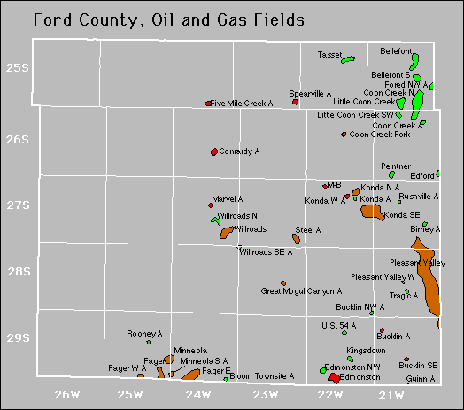

Abandoned
Bucklin Northwest
Coon Creek
Konda
Rushville