| Year | Oil | Gas | ||||
|---|---|---|---|---|---|---|
| Production (bbls) |
Wells | Cumulative (bbls) |
Production (mcf) |
Wells | Cumulative (mcf) |
|
| 1995 | 92,673 | 316 | 22,718,174 | 1,038,334 | 26 | 6,717,113 |
| 1996 | 86,549 | 258 | 22,804,723 | 1,216,815 | 40 | 7,933,928 |
| 1997 | 88,788 | 303 | 22,893,511 | 707,364 | 41 | 8,641,292 |
| 1998 | 76,149 | 307 | 22,969,660 | 216,487 | 37 | 8,857,779 |
| 1999 | 71,355 | 296 | 23,041,015 | 168,072 | 32 | 9,025,851 |
| 2000 | 78,115 | 300 | 23,119,130 | 163,870 | 29 | 9,189,721 |
| 2001 | 79,657 | 285 | 23,198,787 | 135,705 | 31 | 9,325,426 |
| 2002 | 75,490 | 274 | 23,274,277 | 123,376 | 27 | 9,448,802 |
| 2003 | 74,192 | 274 | 23,348,469 | 88,877 | 32 | 9,537,679 |
| 2004 | 71,311 | 262 | 23,419,780 | 55,617 | 29 | 9,593,296 |
| 2005 | 74,877 | 262 | 23,494,657 | 48,068 | 22 | 9,641,364 |
| 2006 | 79,922 | 244 | 23,574,579 | 46,566 | 21 | 9,687,930 |
| 2007 | 72,046 | 270 | 23,646,625 | 36,415 | 20 | 9,724,345 |
| 2008 | 69,856 | 276 | 23,716,481 | 27,009 | 19 | 9,751,354 |
| 2009 | 69,724 | 232 | 23,786,205 | 14,062 | 22 | 9,765,416 |
| 2010 | 65,763 | 242 | 23,851,968 | 16,781 | 3 | 9,782,197 |
| 2011 | 70,402 | 245 | 23,922,370 | 20,030 | 3 | 9,802,227 |
| 2012 | 93,921 | 267 | 24,016,291 | 15,522 | 3 | 9,817,749 |
| 2013 | 81,931 | 255 | 24,098,222 | 12,189 | 3 | 9,829,938 |
| 2014 | 76,814 | 253 | 24,175,036 | 10,380 | 3 | 9,840,318 |
| 2015 | 65,966 | 261 | 24,241,002 | 8,483 | 3 | 9,848,801 |
| 2016 | 56,972 | 271 | 24,297,974 | 7,904 | 1 | 9,856,705 |
| 2017 | 52,346 | 277 | 24,350,320 | 5,422 | 1 | 9,862,127 |
| 2018 | 57,269 | 277 | 24,407,589 | 524 | 1 | 9,862,651 |
| 2019 | 52,572 | 238 | 24,460,161 | - | - | 9,862,651 |
| 2020 | 47,486 | 242 | 24,507,647 | - | - | 9,862,651 |
| 2021 | 48,533 | 232 | 24,556,180 | 1,332 | 1 | 9,863,983 |
| 2022 | 46,226 | 248 | 24,602,406 | 615 | 1 | 9,864,598 |
| 2023 | 52,852 | 227 | 24,655,258 | - | - | 9,864,598 |
| 2024 | 52,850 | 224 | 24,708,108 | - | - | 9,864,598 |
| 2025 | 46,987 | 224 | 24,755,095 | - | - | 9,864,598 |
| 2026 | 6,966 | 160 | 24,762,061 | - | - | 9,864,598 |
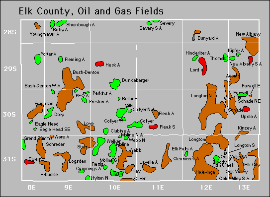

| Abandoned | ||
|---|---|---|
| Bunyard Clear Creek Heck Kinzey Kipfer |
Lavelle Moline South Oak Valley South Perkins Shambaugh |
Upola Youngmeyer |
Gas Storage Fields