| Year | Oil | Gas | ||||
|---|---|---|---|---|---|---|
| Production (bbls) |
Wells | Cumulative (bbls) |
Production (mcf) |
Wells | Cumulative (mcf) |
|
| 1995 | 21,245 | 168 | 2,450,394 | - | - | 0 |
| 1996 | 21,457 | 343 | 2,471,851 | - | - | 0 |
| 1997 | 21,155 | 350 | 2,493,006 | - | - | 0 |
| 1998 | 18,900 | 333 | 2,511,906 | - | - | 0 |
| 1999 | 17,467 | 331 | 2,529,373 | - | - | 0 |
| 2000 | 18,253 | 338 | 2,547,626 | - | - | 0 |
| 2001 | 18,987 | 346 | 2,566,613 | - | - | 0 |
| 2002 | 17,711 | 349 | 2,584,324 | - | - | 0 |
| 2003 | 18,840 | 417 | 2,603,164 | - | - | 0 |
| 2004 | 20,320 | 469 | 2,623,484 | - | - | 0 |
| 2005 | 23,216 | 468 | 2,646,700 | 37,822 | 12 | 37,822 |
| 2006 | 27,341 | 485 | 2,674,041 | 30,203 | 12 | 68,025 |
| 2007 | 27,771 | 488 | 2,701,812 | 17,740 | 12 | 85,765 |
| 2008 | 29,419 | 531 | 2,731,231 | 28,325 | 23 | 114,090 |
| 2009 | 30,790 | 548 | 2,762,021 | 37,895 | 25 | 151,985 |
| 2010 | 28,434 | 549 | 2,790,455 | 25,041 | 22 | 177,026 |
| 2011 | 29,056 | 557 | 2,819,511 | 10,864 | 21 | 187,890 |
| 2012 | 31,695 | 655 | 2,851,206 | 423 | 13 | 188,313 |
| 2013 | 27,616 | 665 | 2,878,822 | - | - | 188,313 |
| 2014 | 27,491 | 631 | 2,906,313 | - | - | 188,313 |
| 2015 | 28,513 | 641 | 2,934,826 | - | - | 188,313 |
| 2016 | 27,222 | 636 | 2,962,048 | - | - | 188,313 |
| 2017 | 27,172 | 654 | 2,989,220 | - | - | 188,313 |
| 2018 | 25,955 | 617 | 3,015,175 | - | - | 188,313 |
| 2019 | 23,884 | 664 | 3,039,059 | - | - | 188,313 |
| 2020 | 18,494 | 596 | 3,057,553 | - | - | 188,313 |
| 2021 | 22,861 | 617 | 3,080,414 | - | - | 188,313 |
| 2022 | 20,123 | 632 | 3,100,537 | - | - | 188,313 |
| 2023 | 21,324 | 657 | 3,121,861 | - | - | 188,313 |
| 2024 | 19,332 | 574 | 3,141,193 | - | - | 188,313 |
| 2025 | 17,171 | 576 | 3,158,364 | - | - | 188,313 |
| 2026 | 3,979 | 444 | 3,162,343 | - | - | 188,313 |
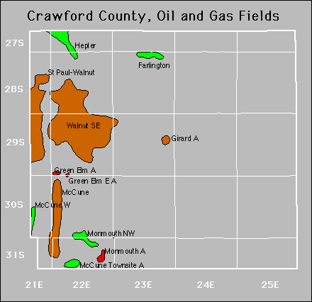

| Active | |||
|---|---|---|---|
| Cherokee Basin Coal Area Farlington Farlington South Girard North |
Girard Northwest Green Elm East Hepler Mccune |
Mccune West Monmouth Northwest Ringo St. Paul-Walnut |
Walnut Southeast |
Abandoned
Girard
Green Elm
Mccune Townsite
Monmouth