| Year | Oil | Gas | ||||
|---|---|---|---|---|---|---|
| Production (bbls) |
Wells | Cumulative (bbls) |
Production (mcf) |
Wells | Cumulative (mcf) |
|
| 1995 | 308,512 | 155 | 8,458,528 | 5,497,043 | 146 | 288,910,854 |
| 1996 | 244,959 | 142 | 8,703,487 | 5,577,803 | 137 | 294,488,657 |
| 1997 | 228,104 | 141 | 8,931,591 | 5,722,981 | 157 | 300,211,638 |
| 1998 | 178,641 | 125 | 9,110,232 | 6,693,323 | 163 | 306,904,961 |
| 1999 | 200,917 | 158 | 9,311,149 | 9,412,469 | 201 | 316,317,430 |
| 2000 | 326,812 | 167 | 9,637,961 | 9,896,846 | 265 | 326,214,276 |
| 2001 | 734,546 | 205 | 10,372,507 | 10,363,288 | 281 | 336,577,564 |
| 2002 | 992,322 | 223 | 11,364,829 | 9,620,239 | 302 | 346,197,803 |
| 2003 | 608,591 | 218 | 11,973,420 | 9,121,021 | 330 | 355,318,824 |
| 2004 | 404,916 | 240 | 12,378,336 | 8,500,539 | 341 | 363,819,363 |
| 2005 | 356,307 | 224 | 12,734,643 | 7,118,167 | 345 | 370,937,530 |
| 2006 | 354,037 | 254 | 13,088,680 | 7,194,943 | 363 | 378,132,473 |
| 2007 | 275,867 | 232 | 13,364,547 | 7,345,746 | 395 | 385,478,219 |
| 2008 | 272,828 | 250 | 13,637,375 | 6,370,102 | 420 | 391,848,321 |
| 2009 | 276,140 | 260 | 13,913,515 | 6,120,940 | 423 | 397,969,261 |
| 2010 | 286,539 | 259 | 14,200,054 | 5,459,025 | 419 | 403,428,286 |
| 2011 | 328,899 | 267 | 14,528,953 | 5,040,263 | 414 | 408,468,549 |
| 2012 | 562,137 | 278 | 15,091,090 | 7,812,291 | 467 | 416,280,840 |
| 2013 | 800,867 | 342 | 15,891,957 | 12,508,579 | 497 | 428,789,419 |
| 2014 | 660,867 | 341 | 16,552,824 | 9,753,243 | 486 | 438,542,662 |
| 2015 | 486,320 | 329 | 17,039,144 | 8,040,637 | 460 | 446,583,299 |
| 2016 | 330,592 | 289 | 17,369,736 | 5,475,051 | 422 | 452,058,350 |
| 2017 | 256,355 | 268 | 17,626,091 | 4,443,874 | 392 | 456,502,224 |
| 2018 | 208,214 | 227 | 17,834,305 | 3,585,874 | 360 | 460,088,098 |
| 2019 | 188,950 | 206 | 18,023,255 | 2,987,192 | 328 | 463,075,290 |
| 2020 | 155,280 | 199 | 18,178,535 | 2,265,673 | 308 | 465,340,963 |
| 2021 | 160,698 | 197 | 18,339,233 | 2,644,010 | 292 | 467,984,973 |
| 2022 | 173,731 | 205 | 18,512,964 | 2,822,044 | 314 | 470,807,017 |
| 2023 | 177,588 | 202 | 18,690,552 | 2,718,337 | 301 | 473,525,354 |
| 2024 | 136,256 | 203 | 18,826,808 | 2,133,079 | 284 | 475,658,433 |
| 2025 | 111,044 | 191 | 18,937,852 | 2,026,046 | 270 | 477,684,479 |
| 2026 | 29,992 | 111 | 18,967,844 | 490,248 | 221 | 478,174,727 |
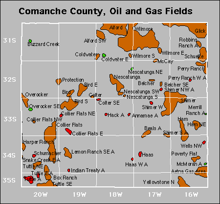

Abandoned
Buzzard Creek Northeast
Mcmoran
Merrill Ranch
Robbins Ranch
Snake Creek East
Tuttle East