News Release, Kansas Geological Survey, December 6, 2022
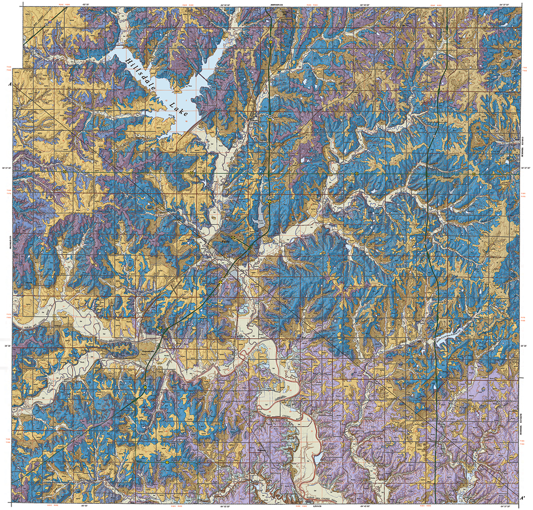
LAWRENCE—The Kansas Geological Survey, based at the University of Kansas, has released a new full-color geologic map of Miami County that highlights the type and age of rock layers found at the surface or immediately below the vegetation and soil in the east-central Kansas county. Shaded relief provides a three-dimensional quality that accentuates the hills and valleys.
Rocks found at the surface in the county, an area of about 590 square miles, formed during the Pennsylvanian Subperiod (299-323 million years ago) when cycles of shallow seas, swamps, and river channels deposited alternating beds of limestone, sandstone, shale, and coal in eastern Kansas. The oldest rocks - the Hertha Limestone - crop out in river valleys in the southeastern part of the county. The youngest rocks - the Stanton Limestone - form the uplands in the northwest.
Miami County lies in the Osage Cuestas region of eastern Kansas, where gently dipping limestones and shales that underlie the entire county have been eroded to create ridges with steep, cliff-like faces on one side and gentle slopes on the other. Agriculture is important to the economy of Miami County, and the county is also home to Hillsdale Lake, a federal public water supply reservoir.
Mapped by KGS geologists Anthony L. Layzell, K. David Newell, Stephan C. Oborny, Rolfe D. Mandel, and John W. Dunham, the new map provides important information about the distribution of limestones used to make aggregate for construction.
Aggregate materials are used to make concrete, mortar, asphalt, and other similar products. Aggregate made from crushed stone is an essential component of the concrete and asphalt used to construct roads. Miami County's limestone aggregate resources are increasingly important to support the transportation infrastructure needs in northeast Kansas, especially in the Kansas City metro about 25 miles north of the county.
The best Miami County limestones for aggregate production are found primarily in rock units that are part of the Upper Pennsylvanian Zarah Subgroup and include the Iola, Argentine, and Lower and Upper Farley limestones.
"The extensive exposures of near-surface Pennsylvanian limestone in Miami County are a major source of construction aggregate material needed to support urban growth in the Kansas City region and transportation infrastructure in the rest of the state," said KGS geologist Jon J. Smith, principal investigator for the KGS STATEMAP geologic mapping project. "Paradoxically, this same growth threatens to envelop potential quarry sites, so it is very important that we identify the location and quality of limestone resources close to Kansas City before they are overtaken by urban sprawl."
STATEMAP is a component of the U.S. Geological Survey's National Cooperative Geologic Mapping Program. A cooperative agreement through this program supported field mapping in Miami County and cartographic work.
In addition to identifying the limestones that are economically important to Miami County and the state, the new map provides vital information to developers as the county's population expands. Much of the new housing in Miami County - one of the fastest growing counties in Kansas - consists of semi-rural developments with septic systems, which require suitable soil conditions to safeguard nearby sources of surface and groundwater.
In septic systems, wastewater filters through soil to remove pathogens, contaminants, and fine particles before it encounters local groundwater or surface water. Sandy or gravel-rich soils may allow wastewater to move too quickly to be properly filtered, but clayey beds may impede wastewater infiltration and saturate the soil until effluent is in contact with the ground surface. Information about the geology of the county found on the new map can be used to assess the suitability of septic system placement.
The geologic mapping in Miami County also provided the impetus for KGS scientists to reexamine the stratigraphic nomenclature (the names of geologic units) of the Pennsylvanian rock layers in the county. The KGS is leading a working group with representatives from Kansas, Nebraska, Iowa, Missouri, and Oklahoma to reconcile the names used for rock units across state lines. New interpretations will be used to rectify miscorrelations among some rock units, which will help identify regionally significant geologic resources.
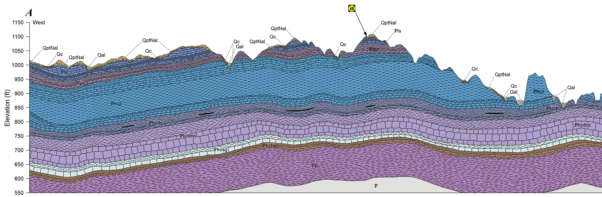
The 68- by 41.5-inch "Surficial Geology of Miami County, Kansas" contains the map as well as a cross section and an illustrated stratigraphic column. The cross section depicts a vertical slice of subsurface rock layers along a line running northwest to southeast across the county. The stratigraphic column shows the order in which rock units were deposited over time and a description of each unit. Towns, roads (from highways to unimproved roadways), elevation contours at 20-foot intervals, and township and range boundaries also appear on the map. The scale is 1:50,000, so that one inch on the map equals about three-quarters of a mile of actual distance. The map can be accessed online.
Paper copies of "Surficial Geology of Miami County, Kansas" may be purchased by contacting the KGS publication sales office at 1930 Constant Ave., Lawrence, KS 66047-3724 (phone 785-864-3965 or email kgs-publications@ku.edu) or the KGS's Kansas Geologic Sample Repository at 4150 W. Monroe St., Wichita, KS 67209-2640 (phone 316-943-2343 ext. 200). The cost is $20 plus shipping and handling and, for Kansas residents, sales tax. More information about county geologic maps and other KGS products is available at the KGS website.
The Kansas Geological Survey is a non-regulatory research and service division of the University of Kansas. KGS researchers study and provide information about the state's geologic resources and hazards, including groundwater, oil and natural gas, rocks and minerals, and earthquakes.